Introduction
Glaciers, moraines and surficial deposits were mapped during field work for a geological map sheet of the Convoy Range (Reference Pocknall, Chinn, Sykes and SkinnerPocknall and others, 1994). The Convoy Range is a north-south-trending mountain range north of the Dry Valleys region of McMurdo Sound, Antarctica (Fig. 1). The range descends eastward from 2000 m at the East Antarctic ice sheet to 800 m at the coastal glaciers. Outlet glaciers of Mawson and Mackay Glaciers bound the area to the north and south. None of the ice from inland sources enters the low eastern areas. The range is arid, with extensive ice-free areas, indicating that ablation exceeds precipitation over most of the area
This study presents information on the present equilibrium of the glaciers of the area as deduced from the disposition and configuration of drifting supraglacial moraine fields, with additional evidence gained from glacier margins and snow cover.
Previous Work
The glaciers of the Convoy Range have been briefly discussed by earlier workers in the region (Reference Gunn and WarrenGunn and Warren, 1962; Reference Mirsky, Treves and CalkinMirsky and others, 1965; Reference Burgess, Palmer and AndersonBurgess and others, 1981). Their reports described the glacial features only in very general terms, interpreting the low-gradient ablation fields of blue ice as “remnants of larger and more active glaciers” and “generally slow moving or stagnant”. No critical assessment of the equilibrium or activity of these glaciers has previously been attempted, although glaciological studies have been made nearby in the Dry Valleys area. These include mass-balance studies made in Wright Valley (Reference Bull and andCarneinBull and Carnein, 1970; Reference ChinnChinn, 1980) and a study of the regimen of the Taylor Glacier trunk (Reference RobinsonRobinson, 1984). A reconnaissance study of the glaciers of the Terra Nova Bay area to the north (Reference Chinn, Whitehouse and HöfleChinn and others, 1989) demonstrated that the present equilibrium of local glaciers could be assessed from elementary, observations. Studies of the margins of polar glaciers have shown that different configurations can provide much information on climate and equilibrium (Reference Holdsworth and BullHoldsworth and Bull, 1970; Reference ChinnChinn, 1986; Reference Chinn and DillonChinn and Dillon, 1987; Reference Chinn, Whitehouse and HöfleChinn and others, 1989) and, in particular, equilibrium can be assessed from ice-cliff heights (Reference ChinnChinn, 1991). A study of a poly thermal debris-covered glacier (Reference Chinn and DillonChinn and Dillon, 1987) demonstrated that much of the glacier's regimen could be deduced from the pattern of debris cover.
Present Glaciers
Westerly katabatic winds dictate the sites of local glaciers by controlling the shapes and locations of snow-accumulation areas. Snow accumulation increases eastward towards the coast, giving an almost complete ice cover which floods the lower ends of the east-facing valleys. The present glaciers are superimposed on a topography inherited from past glacial and climate systems, and many are discordant with the cirques and valleys (Reference Pocknall, Chinn, Sykes and SkinnerPocknall and others, 1994). At lower elevations, ice has flooded into valley systems from the lower ends. Here, ice-flow directions are complex, with diverging and up-valley flows common. There are extensive ablation areas of “blue ice” occurring mainly on Benson and Fry Glaciers.
Glaciers of the region have been subdivided into three types according to ice sources:
-
The East Antarctic ice sheet to the west and associated outlet glaciers.
-
A piedmont-glacier complex between the Convoy Range and the coastal hills
-
Small local glaciers, mainly at mid to high elevations.

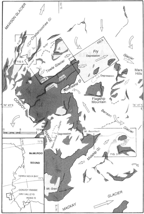
Fig.1 Location map, showing locations of figures and main ice-flow directions
Past Glacial Extents
During the Pleistocene, the ebb and flow of glaciers followed major climatic cycles. Cold glacial episodes reduced inland precipitation, causing the East Antarctic ice sheet and local glaciers to wane while, coincident with world-wide falling sea levels (caused by growth of Northern Hemisphere ice sheets), the marine ice shelves thickened and expanded both inland to invade present coastal areas and outward to near the edge of the continental shelf. These ice-shelf expansions are known as Ross Sea glaciations (Reference Stuiver, Denton, Hughes, Fastook, Denton and HughesStuiver and others, 1981; Reference Denton, Bockheim, Wilson and StuiverDenton and others, 1989).
During interglacial episodes, inland precipitation probably increased (Reference Stuiver, Denton, Hughes, Fastook, Denton and HughesStuiver and others, 1981), and both the ice sheet and local glaciers grew in volume, while the Ross ice sheet shrank. In the present climate, which is interglacial, local glaciers and the East Antarctic ice sheet should be close to their maximum extents and levels, and the marine ice shelves should be withdrawn towards minimum positions.
Westward inundation of the lower valleys by inland incursions of the Pleistocene Ross Sea advances carried tills derived from coastal rocks up to altitudes of 1000 m. Granitoid erratics in these tills serve as ice-movement indicators, because the only known sources of granitoid rocks are east of the Convoy Range.
Methods
Features indicative of glacier balance and glacier-margin fluctuations include the presence or absence of granitoid erratics which allow differentiation between deposits of the last ice-sheet expansion and those of the Ross Sea events. Here, the distribution of specific granitoid erratics may also permit reconstruction of past ice-flow trajectories.
On local glaciers, estimates were made of the accumulation-area ratio- the ratio of the accumulation area to that of the entire glacier. On average, glaciers in equilibrium have ratios of near 0.6 (UNESCO/IAHS. 1970). Recent ice-margin fluctuations were assessed from both recent_ moraines and the morphology of cliffed margins following the method of Reference ChinnChinn (l991).
Evidence From Supraglacial Moraine Fields
Ice flow normally conveys debris completely through a glacier system to be dumped at the terminus. But, on many low-gradient, low-velocity, complex streams of Antarctic glaciers, local ablation may exceed flow and ice flow is then directed laterally towards these local ablation centres. Over long periods of time, accumulation by ablation and converging flow at low-gradient, low-velocity polar glacier systems may form extensive fields of supraglacial moraine, the most spectacular example reported being the 20 km long supraglacial moraine between Beardmore and Law Glaciers (Reference Cassidy, Harvey, Schutt, DeLisle and VanaiCassidy and others, 1992). These drifting moraine fields have a morphology determined by ice flow and ablation, and are located both at glacier margins and at isolated “blue-ice” fields. Those occurring in the middle of ice fields have been the sites of many meteorite finds and have been termed meteorite-stranding surfaces (Reference Cassidy and WhillansCassidy and Whillans, 1990; Reference Cassidy, Harvey, Schutt, DeLisle and VanaiCassidy and others, 1992). Where there is no loss of debris, such supraglacial moraines accumulate for as long as the particular glacial regime continues. Boulder-weathering and meteorite-exposure ages (Reference Cassidy and WhillansCassidy and Whillans, 1990) suggested that many ablation centres may persist for over 0.5 Ma. The antiquity and numerous occurrences of these moraine fields indicate remarkable persistence of stability in Antarctic ice regimes.

Fig.2 Jetsam LineFootnote * and Flotsam Moraines from Mount Razorback. See text for explanation.
When the glacier regime changes sufficiently to deform or to “drain” a moraine field, the patterns within the field will be distorted by the changed ice flow, signalling a change in flow regime. The results may appear superficially similar to moraine configurations on surging glaciers but the perturbations to polar moraines can arise from very minor changes to the glacier regime, operating over very long intervals. The shape and distribution of supraglacial debris areas can give much information on glacier equilibrium and movement. By tracing back along ice-flow vectors heading to a moraine field, the directions from whence the debris came can be determined. (Ice-flow vectors closely follow surface slope and may be approximated by normals to mapped contours.) By this method, distortion and folding of supraglacial moraine fields were unravelled to ascertain the nature of changes to the glacier regime.
Results
Equilibrium of drifting moraine fields
The presence of large “blue-ice” ablation areas on Fry, Towle, Northwind and Benson piedmont glaciers has led to speculation that these low-gradient, low-activity ice masses are wasting remnants of once larger glaciers (Reference Mirsky, Treves and CalkinMirsky and others, 1965). However, when the area of these ice fields is compared with the vast area of their feeder névés, the accumulation and ablation-area ratios are found to be compatible with glaciers in equilibrium. A number of moraine fields, however, showed configurations that could not be expected to persist under equilibrium and hence indicate changes currently occurring within the glacier regime.
Jetsam Line Footnote * and Flotsam Moraines
A clear illustration of glacier disequilibrium is given by the Jetsam Line Footnote * and Flotsam Moraines complex of the Midship/Benson Glacier complex (Reference Burgess, Palmer and AndersonFig. 2). Two sub-parallellines of debris extend down Benson Glacier from these moraines in a very striking, even curve which continues for 12km before terminating where the two lines coalesce on an ablation zone (Reference Cassidy and WhillansFig. 3a). If debris supply to this line had been continuous in the past. The line would continue for the full length of the glacier. The present termination point, “B” (Reference Cassidy and WhillansFig. 3), cannot be stationary as it has to move with ice flow, so its position dates from the time when the two glaciers joined to become confluent.
By back-tracking along present flow lines, it is found that the debris lines originated from a moraine accumulated at the contact between the two glaciers. It is asserted that Jetsam Line moraine originally formed at a terminus of Midship Glacier, separate from the main Benson Glacier ice, at a position somewhere between Mount Razorback and Black Pudding Peak (Λ in Reference Cassidy and WhillansFig. 3). Flotsam Moraines were also part of this complex and accumulated in distributory lobes below Mount Brøgger. With an expansion of Midship Glacier, the frontal, or Jetsam Line moraine, was carried forward to join the Benson Glacier ice, when both the moraine and a ribbon of Midship Glacier ice were extended around Black Pudding Peak to its present position at B in Reference Cassidy and WhillansFigure 3. Meanwhile, an expansion of the snow fields on the slopes of Mount Br∅gger distorted the Flotsam Moraines as they were carried out into Midship Glacier. The end of Jetsam Line moraines at present must be moving downstream at the rate of ice flow. The distance the Jetsam Line moraine has been carried since the two glaciers joined is about 8 km, and with a flow rate estimated at between 1 and 5 m a-1 (Reference RobinsonRobinson, 1984; Reference ChinnChinn, 1986), the time since the glacier expansion commenced is between 8000 and 1600 years.
Hence, this moraine system is interpreted as indicating a significant expansion of Midship Glacier over the last few millennia.

Fig.3 Jetsam Line Footnote * and Flotsam Moraines. a. Present configuration. b. Conjectural configuration for accumulation of supraglacial debris. See text for explanation.
Slackwater and EddyFootnote * Cirques
Arcuate debris bands in Slackwater and Eddy Cirques (Reference Cassidy, Harvey, Schutt, DeLisle and VanaiFig. 4a) were presumably carried into these cirques by distributory lobes of Towle Glacier at a time when ice flow into these cirques from Eastwind Ridge was limited to non-existent (Reference Cassidy, Harvey, Schutt, DeLisle and VanaiFig. 4b). Increased ice input from Eastwind Ridge into the cirques has reversed flow and the moraine fields have distorted as they drifted slowly back out of the cirques towards the main trunk of Towle Glacier. Any debris that may have accumulated in Riptide Cirque has been completely swept away. Being close to the snow line, where net balance at the ice surface is close to zero, these moraines may have been near their present positions for some thousands of years.
The patterns of these moraine fields are interpreted as indicating expansion of the glaciers on the local ranges within the last few millennia.
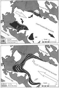
Chattahoochee Glacier
Two moraine fields either side of the “névé” of Chattahoochee Glacier (Reference ChinnFig. 5a) have no obvious source for the debris. Their positions suggest that they are the lateral remnants of a moraine field which accumulated when a distributory glacier flowed north west ward into this valley (Reference ChinnFig. 5b). It is suggested that increased snow accumulation blowing over the head wall saddle has reversed the direction of ice flow but has been insufficient to carry all of the debris away
Moraines of this glacier are interpreted as indicating an expansion of the glaciers on the local ranges within the last few millennia.
Bowsprit Moraine
A feature which supports the idea that at least a part of these ice fields is a remnant of an earlier system is Bowsprit .Moraine, at 800 m above sea level between Towle and Northwind Glaciers. It is discordant with the present glacier regime (Reference ChinnFig. 6). The debris is a medial moraine at the glacier front and presumably is of englacial origin. However, the entire area of debris lies in an ablation area flowing from a broad ice divide on Fry Glacier where there is currently no source of supply to the moraine. The debris includes a pink granite which is known only to the east in the vicinity of Mars Hills, a site which is now “downstream” and at a lower altitude than Bowsprit Moraine. The intervening glacier surfaces are at present so close to being horizontal that present flow directions cannot be accurately assessed, but it is assumed that a reversal of flow has occurred since the last time that ice of Fry Glacier was at an elevation enabling westward now towards Bowsprit Moraine. This could have occurred only at the last high stand of the last Ross Sea glaciation, dated from the nearby Taylor Valley at between 13 000 and 6000 year BP (Reference Denton, Bockheim, Wilson and StuiverDenton and others, 1989). Presuming that ice surrounding the moraine can be no younger than this event begs the question of how could ice have survived a period of perhaps 6000-13 000 years in this ablation zone? With an estimated annual ablation rate of 200 mm a-1 (Reference ChinnChinn, 1980) over this period, about 2 km of ice must have been lost from the glacier surface at the moraine location. The problem may be partially resolved if this ice loss has, until relatively recently, been compressed and replaced by a westward flow of Fry Glacier ice. Alternatively, or in conjunction with this mechanism, the moraine and associated ice may have resided for most of the period beneath an expanded accumulation zone overlying an area of very limited movement by flow.
Whatever its origin, this feature is a relict configuration: one of the few known cases of relict ice within a glacier.

Fig.4 Slackwater and EddFootnote * Cirques. a. Present configuration. b. Conjectural configuration for accumulation of supraglacial debris. See text for explanation.
Equilibrium Of Accumulation Areas
Present mass balance of the smaller local glaciers was estimated from the accumulation-area ratio. The smaller mid-altitude glaciers of the Convoy Range all have very limited or no ablation areas with bare ice showing, their lower margins are commonly entirely covered by snowdrifts. Estimated ratios, in the range of 0-0.4, are well below the equilibrium mean of 0.6, and are very similar to those of the nearby Terra Nova Bay area (Reference Chinn, Whitehouse and HöfleChinn and others, 1989). The disproportionately low area of ablation suggests that the region has recently (in terms of decades) undergone a change of climate to produce more extensive snow cover, with snowfields encroaching over both existing glaciers and bare ground. The change is interpreted as indicating an increase in precipitation over the past century.

Fig.5 Chattahoochee Glacier. a. Present configuration. b. conjectural configuration for accumulation of the supraglacial debris. See text for explanation
Névé Disequilibrium Features
Glacier accumulation areas seldom give hints of their state of balance but large-scale sags, up to 100m in depth and over 1 km in width, were observed in snowfield areas of Fry Glacier, Staten Island Heights and in a snowfield north of Flagship Mountain (Reference Bull and andCarneinFig. 1). Given sufficient time, ice flow will ultimately fill such hollows. These features are interpreted as reflecting underlying topography beneath a “thin” growing snow field where ice flow has yet to reach equilibrium with accumulation.
Lake Levels
Trends in level of lakes and ponds within the region also indicate climate trends. Stranded algae around the margins of ponds show that surface levels have been lowering. Although this trend contrasts with rising lake levels of the nearby Dry Valleys area (Reference ChinnChinn, 1993), both results indicate climate warming. This seemingly paradox stems from the position of the lake with respect to the regional snow line. In the Convoy Range, lakes are close to the regional snow line and warming climate has increased precipitation (snowfall) so that meltwater run-off has diminished (Reference ChinnChinn, 1979), while the same warming has enhanced meltwater run-off into the Dry Valleys lakes, which are well below the snow line.
Equilibrium At The Glacier Margins
Polar glaciers of the McMurdo Sound region terminate in various forms, ranging from gentle ramps through domed fronts to calving ice cliffs. It has been shown that the equilibrium of a glacier margin may be assessed from its morphology and, in particular, ice-cliff equilibrium may be assessed from its geometry (Reference ChinnChinn, 1986,Reference ChinnChinn 1991). Where there is a well-developed apron and the total cliff height is over 30 m then the glacier front is advancing (Reference ChinnChinn, 1986,Reference ChinnChinn 1991 ). Few ice cliffs are well developed in the area but those seen were all below 30 m in height and displayed little to no apron formation. Taken together, these observations indicate that the glaciers are receding.
One glacier on Mount Brøgger had low ice cliffs indicative of a receding front but was completely surrounded by a permanent snowfield. The implication is that this glacier is continuing to withdraw in response to a past climate of lower precipitation, while a relatively recent expansion of snow cover has been superimposed upon this glacier recession.

Fig.6 Bowsprit Moraine, showing present position and ice-movement directions. See text for explanation
Equilibrium From Recent Moraines
Margins of glaciers were examined to see whether the ice was over-riding or withdrawing from recent moraines. Limited exposures of the margin of Mackay Ice Sheet outlet glacier show no evidence of recent recession nor any Holocene moraines. This glacier is likely to be close to its Holocene maximum level.
Margins of smaller local glaciers and piedmont glaciers have Holocene moraines from within a few metres to some hundreds of metres from their margins. These moraine positions indicate general recession but, as these glaciers have response times to climate changes of the order of thousands of years (Reference ChinnChinn, 1986), this trend is an artifact of a period of recession prior to the present positive balance.
Conclusion
Moraine fields in the Convoy Range indicate glacier disequilibrium. Moraine configurations all suggest that local glaciers are expanding in response to a past “warmer” climate of higher local precipitation, estimated from the amount of moraine movement on Benson Glacier to have occurred between 2000 and 8000 year BP. This “warmer” period is most likely coincident with the worldwide “climatic optimum” at about 6000 year BP. The moraine fields all occur on large glaciers which have long response times, so that the expansion which they record has presumably already passed through the smaller steeper glaciers, leaving them in a state of retreat.
Small moraines in front of some local glaciers indicate that these glaciers have been slightly larger at some past time during the Holocene and are currently retreating. However, ice-sheet variations recorded by moraines at the margin of Mackay Glacier show no evidence of Holocene recession, suggesting that this glacier is close to its Holocene maximum level.
Expanding areas of snow cover have given a Recent (decades to hundreds of years) positive balance to the mid-to high-altitude glaciers. This change to positive mass balance, which has yet to affect the fronts of any of the glaciers, has been superimposed on a general state of glacial recession. In this area of continuous sub-zero temperatures, climate warming is indicated by an increase in precipitation and subsequent glacier advance, possibly since the “Little Ice Age” which ended in the last century.
When all features indicating glacier equilibrium are compared, there are two apparently conflicting results; whereas one set of indicators suggests that glaciers are advancing, another set points towards recession. There is no problem with this apparent conflict when one considers the differing response times of polar glaciers. The time taken for a change in mass balance from a climate change to pass through to the glacier front is in the order of thousands of years (Reference ChinnChinn, 1986). The drifting moraine fields and margin fluctuations are responding to glacier thickening from long (thousands of years) in the past, whereas the surface mass-balance changes indicate a change to positive mass balance in the immediate past (tens to hundreds of years).
Acknowledgements
The expedition is grateful for the co-operative support provided by the personnel of Scott Base and logistics support provided by the U.S. Navy. This research was carried out under contract No. CO5232 of the New Zealand Foundation for Research and Technology.