


INTRODUCTION
Ethiopia has the largest livestock population in Africa and it is ranked ninth in the world [1]. The very diverse geography/geology of the country defines several agro-ecological zones. The central part is characterized by a zone of highlands surrounded by a temperate transition zone that plunges into the central Rift Valley towards the south west. To the east, the lowland areas, i.e. zones of pastoral nomadic livestock husbandry are found [2].
The climate is characterized by a long rainy season called meher from June to September representing about 75% of the annual rainfall, and a short rainy season called belg from February/March to April/May. The dry season extends from October to January [Reference Larbodière3]. Heavy rainfall during meher, low temperatures at the beginning of the long dry season and lack of water at the end of this season can be important constraints for agriculture and livestock production [Reference Ayelet4, Reference Gopilo5].
Around half of the small ruminants in Ethiopia are found in the Highlands with a population mainly comprised of sheep. Production systems of goats are not well documented in that region but usually follow the same pattern as those of sheep where they occur. Goats are mainly raised by traditional farmers together with other livestock in combination with agricultural activity. The mixed livestock–agriculture system with small herds present in the Highlands contrasts with the pastoral system found in the lowlands where larger flocks/herds are found [Reference Mukasa-Mugerwa and Lahlou Kassi6, Reference Tibbo7].
Grazing tends to be communal during the dry season and individual during the rest of the year with owners grazing the animals on their own land. A study by Larbodière [Reference Larbodière3] estimated that 90% of farmers mixed their animals with other flocks in the same village but most of them (80%) stop this practice during the long rainy season.
The process of ‘villagization’ during the mid-1980s in Ethiopia pushed farmers away from their plots of land. Moreover, in zones of intense cropping small ruminants shepherded mainly by children graze some distance away from the village [Reference Luling8].
Little is known about the contact structure of the farming population in developing countries, but it is likely to be complex and heterogeneous as a result of the need for continuous adaptation to variable environmental, socioeconomic, and institutional conditions. Management practices that favour contacts between animals from different origins in regions situated between the two parallels of 40° latitude north and south, are often used to explain the persistence of a number of directly transmitted diseases [Reference Bronsvoort BM de9]. Mixing at watering points (WPs) or grazing points (GPs) has been identified as a key factor for transmission of diseases such as rinderpest, peste des petits ruminants (PPR) or foot-and-mouth disease (FMD) [Reference Lefevre, Blancou, Lefevre, Blancou and Chermette10].
Social network analysis allows a description of the topology of the contact structure of livestock populations. The impact of network structures on the potential routes of transmission of infectious diseases can be investigated, provided that the network links are associated with known risk factors for disease transmission. Previous studies have shown the impact of such structures on the efficacy of surveillance and disease control programmes [Reference Woolhouse11–Reference Kao13] using animal movements in intensive farming systems. However, the characterization of networks of animal contacts in settings without registered animal movements and structured animal contacts remains a challenge in terms of field network data collection and knowledge about the husbandry system. The aim of this study was to better understand the contact structure of the small-ruminant population in a selected area of Ethiopia by developing networks that reflect the natural heterogeneous mixing of flocks in a traditional mixed livestock–agriculture sedentary production system. The specific objectives were to describe, analyse and compare the contact networks generated through shared use of small ruminants' WPs and GPs in a region (wereda) of the Highlands in Ethiopia at different administrative levels (kebelle, villages) and to discuss the implications of such structures for the design of disease surveillance and control activities.
METHODS
Study site and sampling method
The study was conducted in the Bassona Werna wereda which covers 1020·35 km2 in the central part of Ethiopia (Fig. 1). This area was selected because of its proximity to Addis Ababa (130 km northeast), and the availability of baseline production information from previous field studies [Reference Larbodière3, Reference Alemayehu and Fletcher14]. The study area represents the two agro-ecological settings usually found in the Highlands: dega from 2300 metres above sea level (m.a.s.l.) to 3500 m.a.s.l. (52%), and woina dega from 1500 to 2300 m.a.s.l. (48%). A stratified multi-stage sampling strategy was used, with the number of kebelles or villages set to a fixed number based on time and resource constraints. Ten out of 29 kebelles of the Bassona Werna wereda were pre-selected for the study according to two accessibility factors: the number of walking days necessary to reach them and the physical ability of the interviewers to reach the kebelles. The two most remote kebelles were included in a pilot study in which study protocol and questionnaires were evaluated, with the remaining eight being involved in the main body of research. In each of the eight kebelles used in the main study, a number of villages were randomly selected as listed in Table 1: 10 villages in five kebelles, 11 in two kebelles and eight in one kebelle. In Gudoberet kebelle, two villages out of the 10 selected were not accessible because of insufficient human resources and were replaced by one in Debele kebelle and one in Bere Ager kebelle, the only two kebelles with 11 villages in the study.

Fig. 1. Study site, location in Ethiopia and topography.
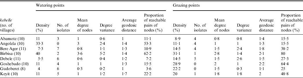
Table 1. Density, isolates, mean degree of nodes, average geodesic distances and proportion of reachable pairs of nodes of common watering/grazing point networks of each selected kebelle from Bassona Werna wereda separately in February/March 2007, where node=villages and link=common watering/grazing point
In each village, 10 small-ruminant owners were selected, using a systematic approach, for individual interviews [Reference Hesterberg15, Reference VanKerkhove16]. Starting from the centre of the village, the interviewer selected every second owner on a straight imaginary line heading north, then moved to the west, south and finally east until 10 small-ruminant owners were identified. Given the average size of the villages this procedure ensured a representative selection of small-ruminant owners. In the evening of the day of the visit a separate questionnaire relating to WP and GP use was administered to a group of children in each of the 80 villages, because the children are usually responsible for taking the animals out for grazing after school and they generally spend time together when possible. In order to increase the reliability and validity of the answers, all available children from the village were assembled to complete one questionnaire per village.
Field data collection
Two questionnaires (one for individual animal owners and another for the group of children) were designed and piloted, using the sampling method described above, in two kebelles selected for this purpose. Double-blind translation was used to validate the questionnaires in Amharic from their original English version. The owner's questionnaire was administered to individual farmers and included questions on flock/herd size and species composition and the possibility of the practice of rebi (keeping animals of other owners in return, e.g. for newborn lambs/kids). The questionnaire for the children focused on the names and time of use of GPs and WPs (long rainy season, short rainy season, long dry season, short dry season).
The questionnaires were administered by three interviewers (two of them being trained by the first one) from February to March 2007. During each visit, global positioning system location of the village was recorded along with the total number of households and the number of households keeping small ruminants.
Data management and analysis
The results of the questionnaires were entered into Microsoft Excel® 2003 (Microsoft Corporation, USA). Descriptive statistics and tests for univariate associations between the variables representing altitude at which the household is located and species composition of the flock/herd were performed using SPSS for Windows version 15.0 (SPSS Inc., USA). For t tests, homogeneity of variance was assessed based on Levene's test for equality of variance and normality was assessed by examination of histograms. Statistical comparisons used α=0·05 (two-sided).
Network data were entered as matrices using Microsoft Excel 2003. Several symmetric (undirected link) binary (presence/absence) networks were built with either kebelles or villages as nodes with the links being ‘sharing WPs’, ‘sharing GPs’. Networks were also built with villages as nodes with ‘sharing WPs’, ‘sharing GPs’ as links for the dry and the rainy seasons. For each individual kebelle (n=8) two symmetric binary networks were created with the nodes being villages and the links ‘sharing WPs’ and ‘sharing GPs’ within the kebelle.
For each network, density (proportion of all possible links that are actually present) and number of isolates (nodes not connected to any other) were calculated. For each node, degree was extracted, defined as the number of alternative sharing villages/kebelles. Average geodesic distances of the different networks defined as the mean number of links in the shortest path (geodesic) between all reachable pairs of nodes were extracted and used as an estimate of the overall power and speed of the network to transmit/diffuse. Whereas density, isolates, and degree primarily deal with adjacencies, the distance between nodes in a network helps to capture how cohesive and connected the network is.
Bootstrap paired-sample t tests were applied to test for differences in density of two networks using 10 000 random permutations per test [Reference Hanneman and Riddle17]. These tests are standard t tests to compare the means of two groups (WPs vs. GPs, rainy vs. dry) but use a permutation test to generate the significance level so that standard assumptions of independence and random sampling are not required. Thus, they take into account that the ‘observations’ in network data are not ‘independent’ samples from a population. Through bootstrapping and permutations, null hypothesis distributions for the test statistics can be generated from the observed networks by using random assignment with thousands of trials [Reference Hanneman and Riddle17].
The quadratic assignment procedure correlation function was used to calculate the correlation between two matrices, using the Jaccard coefficient based on 5000 permutations. Statistical tests of network data were conducted using UCINET 6.182 (www.analytic-tech.com/) and visualization of the networks with Pajek 1.21 (http://vlado.fmf.uni-lj.si/pub/networks/pajek/).
RESULTS
Questionnaire results
Data from 80 villages ranging in altitude from 2655 to 3336 m.a.s.l. were collected. On average 82% of the households investigated had small ruminants. Locations of the investigated kebelles and villages are shown in Figure 2.

Fig. 2. Map of Bassona Werna wereda showing the administrative boundaries of all kebelles and the locations of the interviewed villages.
The kebelles had a median of 1284 small ruminants [interquartile range (IQR) 1192–1313]. The villages had a median of 27 households with small ruminants (IQR 22–34) and the median flock had 10 sheep (IQR 6–15) and no goats (IQR 0–1). Sixty-nine villages (86%) had households rearing sheep and goats, nine (11%) had only sheep and the information was missing for two villages (2·5%). Villages keeping both species were situated at a significantly higher altitude than villages with only sheep (t test for independent samples: P<0·001). In 27% of the interviewed villages at least one owner declared that they practised rebi.
Two subgroups of villages could be distinguished based on the geographical position in the wereda and altitude: one located west of the wereda including three kebelles (Goshebado, Angolela, Birbisa) with an altitude between 2500 and 2900 m.a.s.l. and the other east of the wereda including five kebelles (Abamote, Keyit, Bere Ager, Gudoberet, Debele) with an altitude between 3000 and 3300 m.a.s.l. During the interviews in the villages, 154 WPs and 208 GPs along with their period of use were identified.
Network analysis
At kebelle level
The networks with kebelle as nodes and links based on ‘sharing GPs’ or ‘sharing WPs’ showed no isolates in their eight nodes and are displayed in Figures 3 and 4, respectively. The average degree of the nodes in the GP network (6, range 5–7), was much higher than the same measure in the WP network (3·2, range 1–5) where there were two nodes linked to a single kebelle. Degree variance was much higher for the WP network (2·31) compared to the GP network (0·5) underlining a higher diversity of kebelles when comparing their number of links to other kebelles with WPs. The average geodesic distance of the 28 possible reachable pairs in a symmetric network of eight nodes without loops was higher for the WP network (1·7) than for the GP network (1·1) with 100% of the pairs of nodes reachable in both networks. The density of the GP network (93%) was also significantly higher than the density of the WP network (46%) (bootstrap paired-sample t test: P<0·001). The Jaccard coefficient (0·467, P=0·013) indicates that the shared use of GPs by kebelles is highly correlated with the shared use of WPs.
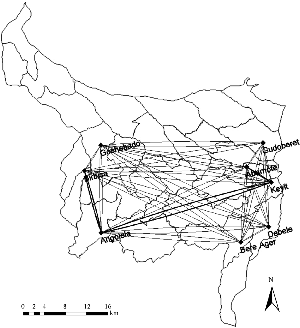
Fig. 3. Grazing points network with nodes being kebelles.
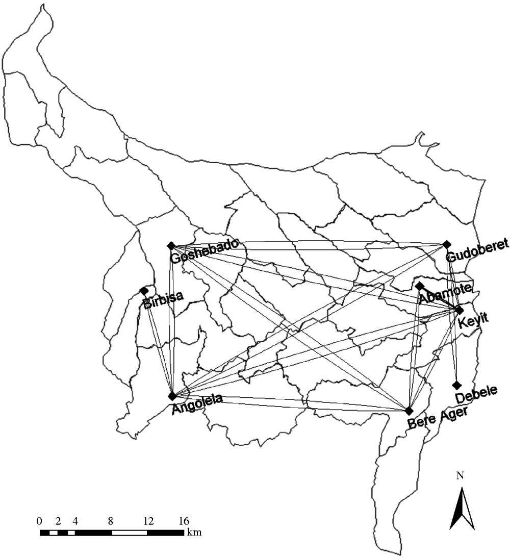
Fig. 4. Watering points network with nodes being kebelles.
At village level
Separate networks for each kebelle
The WP and GP networks for each kebelle (n=8) with villages as nodes present a very variable structure between and within kebelles. Table 1 presents a summary of the extracted parameters for each of the 16 networks that were built. The isolates were more abundant in the WP networks compared to the GP networks.
The mean degree of the villages within kebelles was very variable in each of the networks, being more variable in the WP networks. The highest average degree of the nodes was found in Birbisa kebelle where villages were on average linked to 3·6 other villages of the same kebelle through WPs although with an important variability (degree variance 5·2). Birbisa was also the kebelle where villages had the largest average degree (2·8) in the GP network.
In general, density was higher in the GP networks compared to the WP networks with the highest values found in the Birbisa kebelle networks with 31·1% and 40% of all possible links present, respectively.
The average geodesic distance was higher for each of the GP networks except in the case of Angolela, which was the opposite. As the proportion of reachable pairs used in the calculus of this parameter was larger for all GP networks (except for Angolela) the cohesion of the GP networks in general are higher than the WP networks confirmed by the density and the number of isolates (Table 1).
Network including all villages
The WP and GP networks using villages had 80 nodes each. Table 2 shows the number of isolates, the density, the degree (range, average, variance), the average geodesic distance and the proportion of reachable pairs for the two networks considered.
Table 2. Isolates, density, degree (including average and variance), average geodesic distance and proportion of reachable pairs of common grazing/watering point networks in the Bassona Werna wereda of Ethiopia in February/March 2007, where node=village (n=80) interviewed and link=sharing watering/grazing point, taking into account seasonality
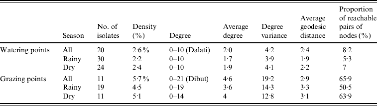
Both networks showed low connectivity, with a density of 2·6% in the WP network and 5·7% in the GP network. The number of isolates when the links were based on shared WP use was almost double the number of isolates based on shared GP use.
On average villages were directly linked to two other villages by means of shared WP use (variance 4·2, range 0–11) and 4·6 other villages via shared GP use (variance 19·2, range 0–22).
The significant difference in density observed at kebelle level was confirmed at village level (P<0·001) with the density of the GP network being higher than the density of the WP network. The Jaccard coefficient (0·259, P<0·001) also confirmed that villages with contacts through shared GP use were more likely to also share WPs.
The average geodesic distance was higher in GP (2·9) compared to WP (2·4) networks. Yet again the proportion of reachable pairs is on average eight times higher in GP networks than in WP networks.
Each of the two networks with villages as nodes (considering ‘sharing GPs’ and ‘sharing WPs’) were then split into two networks in order to take into account the seasonality of the links between villages (rainy season and/or dry season). Table 2 reports the same extracted parameters for the networks of links during the rainy and dry seasons for the GP and WP networks.
In general rainy and dry GP networks have less isolates, higher average degree, larger degree variance, larger average geodesic distance, and larger proportion of reachable pairs than the corresponding WP networks. The density of the WP network during dry season was significantly higher than during rainy season (difference in density 0·003, bootstrap t test two-tailed: P=0·04), which was not the case for the GP networks (P=0·22). The rainy and dry season networks were significantly correlated for WP and GP cases (Jaccard coefficient 0·906, P<0·001 and Jaccard coefficient 0·77, P<0·001, respectively), indicating that villages sharing WPs and GPs during the rainy season are more likely to also share them during the dry season.
DISCUSSION
The aim of this study was to describe and compare the networks for small-ruminant flocks generated by shared use of WPs and GPs at different administrative levels in the Highlands of Ethiopia. To our knowledge it is the first time a field study of this kind has been conducted in Sub-Saharan Africa.
It should be noted that the purposive selection of kebelles within the wereda based on accessibility criteria may have resulted in some degree of bias limiting the ability to generalize the results. Thus our results should be interpreted as representative of the shared use of WPs and GPs in the studied kebelles. Since the proximity and adjacency of the kebelle and village boundaries have not been taken into account, some parameters describing the networks and the nodes may have been affected, but they still allow comparisons across the constructed networks. Although the questionnaires were administered once at the beginning of the rainy season, patterns of seasonal variation could also be addressed by using retrospective information. Given the impossibility of validating responses, the potential for recall bias, a weakness common to any questionnaire-based survey, was minimized by conducting group interviews of children and allowing the participants to reach an agreement upon the answers given [Reference Bronsvoort BM de9]. Results obtained regarding small-ruminant population structure and management practices were similar to those reported 15 years ago [Reference Larbodière3, Reference Mukasa-Mugerwa and Lahlou Kassi6]. The relatively homogenous structure of the small-ruminant farms across the kebelles and villages interviewed suggest that the GPs and WPs frequented would not be dependent on the herd size parameter in our study.
Despite GPs being more abundant than WPs, individual GPs appeared to provide more contact opportunities for animals from different kebelles and villages as shown by the lower number of isolates, higher density, and degree values of the corresponding networks. Expansion of cultivated land forcing farmers to increase mobility when searching for GPs shared by multiple villages could explain this result. This effect was stronger in villages located in the highest altitude areas of the Highlands which tend to be more isolated and rear mixed flocks of sheep and goats. As expected the WP network was denser during the dry season when some of the WPs become unavailable with less isolates, with temporary WPs close to the villages probably disappearing. The increase of average degree could then possibly be explained by villages redirecting their flocks to common WPs and establishing links with other villages.
There was great variability in the contact structure of the networks of villages within kebelles for both networks, in terms of number of isolates, degree and degree variance. Some villages did not share any WPs or GPs with other neighbouring villages suggesting that these villages would be naturally at much lower risk of introducing disease with geographical boundaries such as mountains or waterways or both possibly preventing contacts. The size of the areas (WP or GP) could also partly explain the number of flocks/herds sharing them although the spatio-temporal boundaries of the GPs and WPs could not be fully addressed in this study given the logistical difficulties in locating and measuring them. The average geodesic distances were in general larger in GP networks, taking more steps to reach a village from any other one. However, given the higher compactness of these networks, the proportion of reachable pairs due to the presence of greater components determines that GPs present a potentially greater ability to transmit/diffuse compared to WPs.
The variability was also observed at kebelle level. Bere Ager, Birbisa, Debele and Abamote appeared to be highly connected via GPs but not so through WPs. Some showed very low connectivity between their villages but were more central when considering the links to other kebelles, e.g. Bere Ager. According to values of the geodesic distance and the proportion of reachable pairs, GPs could be considered again as riskier for disease transmission compared to WPs. In summary and in the light of these results, GPs appear to be more important than WPs as contact points for small ruminants in the Highlands of Ethiopia at village and aggregated kebelle scale. Both scales were explored with no previous knowledge as to whether either the kebelle or the village should be considered a more appropriate epidemiological compartment based on contacts. Contrary to the common assumption that congregation of livestock at WPs is critical for the potential transmission of infectious diseases, the results of the current study suggest that interventions associated with shared grazing areas in the Ethiopian Highlands may be more important for the contact between flocks. Moreover since small ruminants spend more time at pasture than drinking at WPs transmission of infectious diseases could be expected to be more facilitated at GPs, increasing the number of flocks/herds at the same place during the same period of time [Reference Mengistu, Dahlborn and Olsson18]. Rotation of the areas used for common and individual grazing in the Highlands and the relatively small size of the current study compared to the diversity and size of the country warrants cautious interpretation of the findings. Similarly the dynamic aspect of the links in the networks studied could not be totally captured by the questionnaire. Yet it is likely that improved awareness by farmers and veterinary services of the potential for disease transmission associated with shared use of grazing areas as well as promotion of biosecurity-conscious management of the grazing rotation may assist in the control and prevention of infectious diseases in small ruminants in the Highlands of Ethiopia [Reference Macpherson19]. Communal GPs of kebelles are therefore the most appropriate location for health interventions like vaccination campaigns. If marking of vaccinated animals is not well received by farmers, cards attesting the vaccination status of the flocks could be delivered as a compulsory requirement for future access to a particular common GP, for example. However, if limiting access to communal pasture might prove to be a difficult task, alternative use of these critical GPs could be proposed. For instance these points could be selected as sentinels for disease surveillance [Reference Christley20] or critical risk points where ‘human and economic resources should be prioritized in order to confront biological disasters’ [Reference Rushton and Upton21]. It would be interesting to ascertain the disease status of some of the villages that appeared to be at a theoretically lower risk given their contact pattern as revealed by their position in the different networks. If the overall healthier status of these villages was confirmed, the outputs of this type of analyses could inform cost-effective risk-based surveillance and control activities at village level [Reference Green, Gregory and Munro22]. This particularly applies to diseases for which transmission is direct and the agent labile in the environment as PPR virus. When indirect transmission occurs with inanimate or live vectors and the agent is more stable, e.g. FMD virus or sheep pox virus, these results should be reconsidered if other parameters have been included, for example management practices with the sharing of material at contact points or on the biology of the vector. Design of transmission models, useful as decision-making tools when looking at different possible strategies of control, could be improved by taking into account our network study if the transmission probability is low [Reference Smieszek, Fiebig and Scholz23], as well as the frequency of contact, and that the random mixing hypothesis cannot be assumed [Reference Eames, Read and Edmunds24–Reference Shirley and Rushton26].
There are other opportunities for contact between small-ruminant flocks, one being through markets [Reference Gopilo5, Reference Bronsvoort BM de9, Reference Lefevre, Blancou, Lefevre, Blancou and Chermette10, Reference Al Majali27, Reference Robinson and Christley28]. Studies should be conducted to describe other contact networks and compare them with GPs and WPs with respect to their structure and likely impact on transmission of infectious diseases. Applying this method within the frame of a larger scale study could help improve the understanding of the contact opportunities and patterns, especially in transition zones between high-altitude areas where small-scale sedentary systems prevail, and lowland pastoral areas. Thus, further recommendations for the surveillance and control of diseases of economic importance for farmers such as PPR, sheep pox, goat pox, and FMD could be made. In conclusion and contrary to common belief, in the Highlands of Ethiopia GPs may offer more opportunities for flock mixing and contact than WPs. Some villages appear to have a much lower risk of introduction of disease as a result of not sharing WPS or GPs with others. Local patterns of contact through sharing of WPs or GPs should be considered in the design of surveillance and control programmes.
ACKNOWLEDGEMENTS
The authors thank Desta Beyene for assistance in the field. This study was carried out as part of the EU-funded INCO-CT-2004-003670 RP/PPR MARKVAC project.
DECLARATION OF INTEREST
None.


