


Introduction
Glacial deposits near the margin of the Laurentide ice sheet record both local and regional ice behavior. Detailed study of a single till unit, the Tiskilwa Till Member ofthe Wedron Formation, in northern Illinois, USA, has permitted interpretation of the processes that were active prior to and during deposition of the unit as well as some of the controlling factors. The Tiskilwa is a thick, extensive late-Wisconsinan (early Woodfordian) till deposited by ice entering the region no later than 23 14C ka BP. Many of the characteristics of the Tiskilwa are unusual in comparison to those of other till units of the Lake Michigan lobe.
Regional setting
Wisconsinan-age glacial deposits of the midwestern United States were deposited by multiple advances of several major glacial lobes of the Laurentide ice sheet. In Illinois, the majority of these materials were deposited by the Lake Michigan lobe, which is subdivided into several sub-lobes. The study area (Fig. 1) is located innorthern Illinois near the southern end of Lake Michigan and includes an area extending 30 to 50 km behind the western margin of the former Lake Michigan lobe.

Fig. 1. Regional map showing Woodfordian glacial boundary and generalized ice-flow directions, surface exposure of the Tiskilwa Till Member, and the study area.
The late Wisconsinan (Woodfordian) glacial advances formed a series of constructional morainic features which become progressively younger toward the north-east. Tiskilwa Till is present in these outermost moraines in northern Illinois and is mappable as the surface unit in alarge region of Illinois (Fig. 1). To the northand east, constructional features of Tiskilwa deposits are completely buried by younger glacial materials.
The Tiskilwa Till MemberFootnote † is the oldest member of the Wedron Formation (Table I) and is underlain by Farmda1ian deposits or older tills of A1tonian (early Wisconsinan) or Illinoian age.It is overlain by younger Woodfordian tills of the Wedron Formation.
Table I. Time and Rock Stratigraphy for Tillunits in the Study Area

Methods
Data were obtained mainly from water-welland test-boring logs and samples on file at the Illinois State Geological Survey. Approximately 530 borings were used, 200 of which penetrated the entire thickness of the Tiskilwa.
Representative samples from these borings were described for texture, color, structure, and other distinctive features. Selected samples were then analyzed for texture and clay-mineral composition. Textural analysis was by sieve andhydrometer methods, which fractionate and determine the weight percentage of gravel(>2.00 mm) in the whole sample and the weight percentage of sand (0.062 to 2.00 mm), silt(0.004 to 0.062 mm), and clay (<0.004 mm) with respect to the matrix (Reference WickhamWickham, unpublished).
Clay-mineral identification, classification, and interpretation were performed by H.D. Glass of the Illinois State Geological Survey from X-ray diffraction data using oriented aggregatetechniques on the <0.002 mm material. Clay minerals are separated into three groups, and percentages of each are calculated using peak height intensities (counts S−l) from a logarithmic scale. These three groups are defined (Reference Willman, Glass and FryeWillman and others, 1966): (1) expandable clay minerals(all materials that expand to approximately 17 Åwhen treated with ethylene glycol including vermiculite and montmorillonite(smectite)), (2) illite (all clay minerals of 10 Å basal spacing that do not expand when treated withethylene glycol), and (3) kaolinite plus chlorite (clay minerals calculated from the intensity of their 7.2 Å basal spacing).
Several other characteristics of the c1ay-mineral diffraction analyses were noted to helpevaluate the clay-mineral data of samples whichhad been altered by post-depositional processes.
Till characteristics
The Tiskilwa is one of the most extensive till units in the region and is present in an area of more than 20 000 km2 in Illinois alone.In a large portion of this area, the Tiskilwa is buried by younger sediments (Reference Willman and FryeWillman and Frye 1970).
On a regional scale, the unit is wedgeshaped and thins in the up-ice direction. The base of the unit is essentially a smooth surface that slopes eastward toward the Lake Michigan basin. The thick terminal deposits occurring in the western part of the region form topographichighs on the modern land surface and in the subsurface.The till is generally 15 to 30 m thick; terminal deposits are 45 to 60 m thick regionally and 75 to 90 m thick locally (Fig. 2). The Tiskilwa contrasts sharply with younger (overlying) units, which generally are 10 m or lessthick and overlap the eastern portion of the unit(Fig. 3).

Fig. 2. Thickness of the Tiskilwa Till Member and location of line of section for Fig.3.

Fig. 3. Typical cross-section of Tiskilwa Till in northern Illinois. See Fig.2 for line of section.
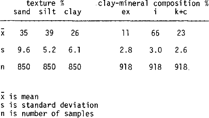
The Tiskilwa has a distinctive red-brown color, sandy texture, and clay-mineral composition. Subjacent and superjacent tills are mainly gray, silty or clayey in texture, and relatively higher in illite content. The composition of the Tiskilwa was intensively analyzed in a part of the study area by using samples from more than 200 individual borings. Grain-size analysis of 850 samples showed an average of 35% sand, 39% silt, and 26% clay (Table II). Clay-mineral composition analysis of 918 unaltered (unoxidized and unleached) samples showed an average of 11% expandable clays, 66% illite, and 23% kaolinite plus chlorite (ex, i, and k+c, respectively, in Table II). The low standard deviation of these data (Table II) emphasize the remarkable, characteristic homogeneity of the matrix of this till unit.
Table II. Summary of Textural and Clay-Mineralanalyses of the Tiskilwa Till Member
The compositional homogeneity, the massive structure, and the lack of substantial amounts of interbedded, sorted material in the Tiskilwa suggest that most of the unit was deposited as basal till. A thin (generally less than 3 m)layer of ablation till, identified by its greater textural and structural variability and its association with stratified deposits, is often found at the top of the unit. Where the Tiskilwa is the surface till in the terminal area, debris flow deposits occur in a pro-glacial position.
A basal zone of a slightly different composition is found locally in the Tiskilwa Till. This basal zone is discontinuous, is variable in thickness (generally 0 to 5 m), and usually is more illitic, finer-grained, and browner than the “typical” Tiskilwa. In many cases, this basal zone truncates the underlying sediments and is gradational upward in most locations.
Sub-tiskilwa surface and geology
The sub-Tiskilwa surface has little relief and slopes regionally to the east and south-east parallel to the dip of the bedrock (about 1.5 m km−1). Pre-glacial bedrock valleys were completely filled prior to the Tiskilwa advance(Fig. 3). Over a significant portion of this relatively flat surface, buried soil profiles and organic silt deposits, mainly Farmdalian in age, are preserved. Where the soil is truncated, the Tiskilwa rests on either older tills or fluvioglacial deposits related to the Tiskilwa orolder tills.
Interpretation of source area
We have primarily used the clay-sizefraction of the till as the basis for determiningits source area. Reference Dreimanis, Vagners and WrightDreimanis and Vagners (1969, Reference Dreimanis, Vagners and Goldthwait1971) observed that the local bedrock usually (butnot always) predominates the coarse, easilynoticedfractions of till. The fine fraction, which contains the terminal grade for the clayminerals and fine-grained sedimentary rocks, isusually the more homogeneous fraction in thetill.
Clay minerals characteristic of the Tiskilwa do not appear to have a source solely in the Lake Michigan basin and must be derived, inpart, from more northern areas. Lake Michigan basin materials are generally high in illite, low in expandable clay minerals, and are derived from the surrounding gray Paleozoic shales. This Lake Michigan source area is reflected in gray Wisconsinan tills in Illinois. Materials from the Lake Superior basin region are derived from Cambrian and Precambrian bedrock that includes extensive formations of red shale, sandstone, and iron. These materials tend to have relativelyhigh percentages of expandable clay minerals, derived from the alteration of chlorite and vermiculite, such as “swelling chlorites”(H.D. Glass, personal communication). These clay minerals so characteristic of the Tiskilwa, are similar to those found in red tills from the Lake Superior region and are likely to have the same source. This implies that some fine-fraction debris of the Tiskilwa was transported at least700 km (Fig. 1).
Another possible source for the red coloration and clay-mineral composition of the Tiskilwa is similar reddish tills of the Winnebago Formation. These Altonian tills underlie the Tiskilwa in the very northern portion of the study area but are much less extensive. Reworking of these tills is probably not a main source for theTiskilwa because the Tiskilwa has a much greater extent and volume of material, and secondly, the composition of the Tiskilwa does not change beyond the Altonian boundary.
Processes of erosion and transport
The composition and character of till are aproduct of source areas and the processes of erosion, transport, and deposition. Erosion and entrainment of debris from both distant and localsource areas is evident in the Tiskilwa. The uniform composition of the thick till indicates amore or less continuous supply of debris from the same source areas and reworking and homogenization (mixing) of entrained materials during transport.
The glacial processes of homogenization that occur within and beneath the ice are not well known and are difficult to interpret, especially for long periods of time in a continental ice sheet. Homogenization processes probably involve differential shear of the debris-rich ice. and repeated deposition and re-entrainment, perhaps by regelation for individual grains as discussed by Reference KemmisKemmis (1981). or by lodgement and plucking or freeze-on for larger aggregates of grains.
Studies of modern glaciers and theoretical considerations show that the temperature of the basal ice, along with ice velocity. ice thickness and bed characteristics. strongly influence many glacial processes. By modeling the basal thermal zones in the ice it may be possible to predict which processes are active in certain parts of the glacier. Reference Boulton, Price and SugdenBoulton (1972) has suggested several possible thermal models that might exist in ice sheets under differing conditions. Some are thermally simple, the entire glacier being eitherwarm-based or cold-based, but most are thermally complex and consist of both cold- and warm-based zones.
We used previous thermal models. such as Reference Boulton, Price and SugdenBoulton's (1972), and interpretations of the source area of the Tiskilwa Till to formulate amodel for a portion of the Laurentide ice sheet during Tiskilwa deposition. We suggest that basal melt waters were produced in an interior zone of basal melting just north of Lake Superior(Fig. 4). The basal water migrated down-ice into the Lake Superior basin region where thermal conditions were such that basal freezing rather than basal melting occurred (Reference WeertmanWeertman 1961).Erosion and entrainment of debris by freeze-on were active. and homogenization of this debris with already entrained debris began. As the basal waters diminished down-ice, the base became cold, and cold-based conditions are inferred for much of the Lake Michigan basin region. In this zone, transport and comminution of debris took place. Near the southern margin of the Lake Michigan basin and toward the glacier terminus, thermal conditions were such that the base was warm and further entrainment, comminution, and homogenization of both local and distant source debris occurred. At the extreme margin, where the study area lies, the base was primarilywarm, but local areas of non-erosion beneath the Tiskilwa suggest the existence initially of eithera thin, cold-based zone or a complex thermal regime with local areas of cold-based ice.

Fig. 4. Model of the ice sheet from the Lake Superior region to northern Illinois showing proposed basal thermal conditions and basal ice processes
This model is in general agreement with amodel of the Laurentide ice sheet developed by Reference SugdenSugden (1977) from calculations and interpretations of ice-surface altitude, ice thickness. Ice surface temperature, mass balance, geothermal heat, and other characteristics of existing icesheets. Sugden's model, although based on a central dome concept for the Laurentide ice sheet, represents a best approximation of the order of occurrence and size relationships of the basal zones.
Depositional processes
In the initial advance, ice in the margin area probably overrode some frozen ground which resulted in cold basal-ice temperatures with little or no erosion (Fig. 5). A complex zoneof melting and freezing existed behind this zone, followed by a warm zone of net basal melting.Eventually geothermal and frictional heat warmed the entire basal ice in the margin area and deposition became the dominant process(Fig. 6).

Fig. 5. Model of the ice-sheet margin showing basal thermal conditions and basal ice processes in the initial phase.

Fig. 6. Model of the ice-sheet margin during the depositional phase.
The morphology (thick. terminal ridges)and compositional homogeneity of, the Tiskilwa Till suggest a model in which debris is stacked during transport at the ice margin (Reference Moran and GoldthwaitMoran 1971).A strong compressive flow regime must have been operative owing to the upward slope of the underlying surface and location in the ablation area. Stacking occurred while either basal or marginal stagnant ice was overridden by active ice. Buried till ridges to the east (Fig. 2) arealso interpreted to be end moraines and indicate fluctuations of the ice margin during deposition.
The dominant process of till deposition was probably melt-out of debris from both active and stagnant basal ice. Although lodgement is the generally accepted term for basal till deposited by active ice (Reference Boulton and GoldthwaitBoulton 1971), the term implies a “plastering on” or mechanical depositional system (Reference Boulton, Wright and MoseleyBoulton 1975). We believe, however, that basal melting is also an integral part of deposition from active ice (Reference DrakeDrake 1977), and melt-out till is used here for basal till deposited from both active and stagnant ice. Evaluation of depositional processes by fabric studies and observations of gross structural characteristics of the lower portions of the till were not possible because of a lack of exposure.
The large thickness of Tiskilwa Till implies that ice was actively transporting homogeneous debris to the margin for a long interval of time. Reference MickelsonMickelson (1971) has estimated that approximately 10 to 30 mm a-1 of till can be deposited as basal melt-out from an active glacier. If we assume that most of the uniform Tiskilwa Till was deposited as basal melt-out atan average rate of 20 mm a−1, 45 m of till would have been deposited in 2.25 ka. The thickest portion of the till (90 m) would have taken approximately 4.5 ka to be deposited at this rate.
The Tiskilwa is thought to have been deposited between about 23 to 25 and 17.5 14C ka BP.This suggests an interval of at least 6 14C ka for active ice transport of debris toward the margin and basal deposition, which is longer than adequate to account for the thickness of till. This interval represents about half of the Woodfordian Substage, and the long period of transport and deposition accounts for the contrast in thickness with younger thin tills that were deposited by ice with shorter periods of ice activity.
The models presented are supported by the characteristics of the Tiskilwa Till and sub-Tiskilwa units. Non-eroded areas beneath the Tiskilwa are indicated where the Farmdale Soil is preserved or there is a fairly complete stratigraphic sequence. The numerous subsurface borings that encountered this condition indicate that the non-erosion areas were fairly large and that the basal sediments were largely undisturbed. This observation suggests the probable existence initially of a marginal coldzone (Fig. 5). Some of the glaciofluvial sediments beneath the Tiskilwa are probably related to the Tiskilwa and represent deposits from an englacial and basal water drainage system. This observation and the large amount of basal till deposition support the eventual development of a large zone of warm ice and basal melting.
Implications with respect to other lake michigan lobe tills
Woodfordian tills of the Lake Michigan lobe tend to be (1) similar to the Tiskilwa in color and composition, (2) grayer and more illitic inclay-mineral composition, or (3) intermediate incolor and composition between these two end members (Fig. 7). Although these differing till compositions clearly reflect different source areas (Reference Lineback, Gross and MeyerLineback and others 1974), we do not believe that there was a change of source area inthe classic sense, i.e., that ice flowed across different areas and thus the glacier loads differed. Instead, we believe that the general flow path down the Lake Michigan basin was more or less the same for all of these units, but the location of dominant entrainment changed with time during glaciation. If much of the entrainment took place in the zone of basal freeze-on, as suggested for the Tiskilwa, this zone appears to have migrated southward (down-ice) during the Woodfordian; this explains the gray, highly illitic, younger tills in northern Illinois (Fig.7), which we interpret to reflect erosion of sediment and bedrock in and around the Lake Michigan basin. Another possible interpretation is expansion of the outer warm zone up-ice at the expense of the inner cold zone. Sufficient erosion could therefore take place in the Lake Michigan basin to dilute the glacier load to the point where the gray, illitic Lake Michigan basin materials dominate the matrix-size fractions.Evaluation of these interpretations will require modeling of basal thermal regimes with time during a glaciation.

Fig. 7. Model of the ice-sheet margin during the depositional phase.
The Piatt Till, in central Illinois (Fig.7), has compositional characteristics intermediate between the gray and reddish tills and may represent material eroded during the transitional time when the source was changing from domination by Lake Superior basin materials to domination by Lake Michigan basin materials.
The composition of the Delavan and Fairgrange Tills appears to have a some what different explanation. These tills occur at the surface in the southern most area of Woodfordian glaciation in Illinois (Fig. 7). They are gray-brown to violet in color, and have textures and claymineral compositions that resemble the Tiskilwa more than the gray, highly illitic end members.As such, these tills also resemble the basal zoneof the Tiskilwa in northern Illinois, and we believe that their origins are related. These tills appear to reflect a basic Tiskilwa composition that has been modified by incorporation of material down-ice after the glacier flowed out of the Lake Michigan basin. In the center of the lobe, the ice was more active and had a longer flow path than the ice on the west flank where the study area was located. As a result there was more opportunity for incorporation of older glacial deposits and Pennsylvanian bedrock south of the Silurian bedrock around the southern margin of Lake Michigan. This greaterdistance of transport apparently also allowed enough homogenization of the newly entrained debris with the load derived up-ice so that the resulting till would have sufficient character, continuity, and thickness to be recognizable as a separate till unit. The Tiskilwa is recognized as a rock unit stratigraphically above the Delavan and Fairgrange Tills to the north (Fig.7) where the distance of transport was less and not enough material was incorporated to alter its composition significantly.
In contrast, only a thin, discontinuous basal zone is recognized in the Tiskilwa in the study area. This zone of till with a slightly different composition is interpreted to be the result of incorporation of local material that remained in the basal zone of the ice. Thus, the basal zone of the Tiskilwa is thought to be genetically similar to the Delavan and Fairgrange Tills. Slightly irregular sub-ice topography and geology, complex basal thermal conditions, and arelatively short flow path may explain the discontinuity and irregularity of this zone.
Summary
The Tiskilwa Till Member of the Wedron Formation represents deposition by basal melt-out at the margin of the Laurentide ice sheet. The Tiskilwa is one of the thickest and most extensive till units in the midwest. Distinctive characteristics include: a very thick, homogeneous till; relatively little ablation till; red color; sandy texture; relatively low illite content;and the presence of discontinuous basal zones of differing composition.
The distinctive characteristics of the Tiskilwa Till are the product of the processes of erosion, entrainment, transport, and deposition of the ice sheet. We suggest that the major erosion and entrainment zone was near the Lake Superior basin during the late Wisconsinan and that the zone migrated into the Lake Michigan basin during succeeding ice advances (pulses).The changing amounts of material entrained from these two basic source areas are indicated by the change in compositions of till units found in Illinois. The basal thermal regime is suggested as a major controlling factor on the location of the zones of entrainment.
Other till compositions, including the basal zone of the Tiskilwa, are interpreted torepresent modification of the up-ice load by local entrainment south of the Lake Michigan basin. The magnitude and extent of this modification appear to depend on the sub-ice conditions and length of the flow path.
The large Tiskilwa Till thickness indicates an ice sheet actively transporting debris to the margin where stacking of debris-rich ice occurred.The homogeneity in the till is in part due to processes that homogenized the debris en route tothe margin (Reference KemmisKemmis 1981) and to processes of basal deposition near the margin. Deposition occurred within an interval of 6 ka or more during the first half of the Woodfordian Substage.
Acknowledgments
The writers gratefully acknowledge the assistance of the Illinois State Geological Survey staff, particularly the following personnel: H.D. Glass, clay-mineral analysis and interpretation; L.R. Follmer, J.P. Kempton, and D.L. Gross, critical reading of the manuscript; F. Graszer, drafting; E. Yeargin and C. Fitzgerald, typing; and I. Nielsen of the editorial staff. Wealso acknowledge early helpful comments and discussions with T.J. Kemmis of the Iowa State Geological Survey, and J.A. Lineback, H.J.H.Harris, and J.T. Wickham of the Illinois State Geological Survey. N.K. Bleuer and R.P. Goldthwait reviewed the paper and offered helpful suggestions.


