


INTRODUCTION
Progressive convergence between the India and Eurasia plates since early Cenozoic has resulted in ~2000–3000 km shortening of crustal material (Molnar et al., Reference Molnar, England and Martinod1993). Crustal thickening beneath the Tibetan Plateau has absorbed the material to a large extent. Part of the material was accommodated by lateral movement (Fig. 1A), such as along the Ailao Shan-Red River shear zone 35–17 Ma ago (Leloup et al., Reference Leloup, Lacassin, Tapponnier, Schärer, Zhong, Liu, Zhang and Ji1995). The dynamic flow model proposes an additional way to accommodate the material: either the high-temperature lower crustal material (Clark and Royden, Reference Clark and Royden2000) or asthenospheric flow (Shi et al., Reference Shi, Wang, Sieh, Weldon, Feng, Chan and Liu-Zeng2017) enabled the material to be highly mobile southeastward around the eastern Himalaya Syntaxis. Fluvial incision and rearrangement in response to regional uplift are probably among the few useful avenues to date and quantify these geodynamic models, which are important to understand their roles in crustal deformation (Clark et al., Reference Clark, Schoenbohm, Royden, Whipple, Burchfiel, Zhang, Tang, Wang and Chen2004; Yang et al., Reference Yang, Suhail, Gourbet, Willett, Fellin, Lin and Gong2020; Zhao et al., Reference Zhao, Zhang, Tao, Wang, Pang, Ma, Zhang, Ma and Xiong2021).

Figure 1. Tectonic and geological setting of southeast Tibet. (A) Topography and major faults of the central and eastern Tibetan Plateau. (B) Topography, major rivers, and active faults in southeastern Tibet. The 5/9/2022 Mw 6.8 Luding earthquake is based on China Earthquake Networks Center. XSH F. = Xianshuihe fault; DLS F. = Daliangshan fault; ANH F. = Anninghe fault; XJ F. = Xiaojiang fault; LMS F. = Longmenshan fault; LT F. = Litang fault; RR F. = Red River fault. (C) Geological map showing the main catchments of the Dadu and Anning rivers, and the sampling locations of this study. The Dadu River originates from the Bayan Har Mountains, drains southward to Shimian on the low-relief southeastern Tibetan Plateau. At Shimian the river abruptly makes a 90° turn, flowing eastward into the Sichuan Basin. South of Shimian, a wide valley appears in the headwaters region of the Anning River.
In the southeast Tibet, fluvial/lacustrine sediments, hundreds of meters thick, are widely distributed along the trunk of the upper course of the Yangtze River and its tributaries: the Yalung River, Dadu River, and Anning River, described as the Xigeda layer in Chinese literature. The occurrence of these sediments suggests large-scale blocking of paleo-rivers associated with locally tectonic activities (Clark et al., Reference Clark, Schoenbohm, Royden, Whipple, Burchfiel, Zhang, Tang, Wang and Chen2004; Clift et al., Reference Clift, Carter, Campbell, Pringle, Lap, Allen, Hodges and Tan2006; Deng et al., Reference Deng, Chew, Mark, Liu, Cogné, Jiang, Sullivan, Li and Li2020; Zhao et al., Reference Zhao, Zhang, Tao, Wang, Pang, Ma, Zhang, Ma and Xiong2021). However, owing to their depositional discontinuity and lack of fossils and isotopic dating, how and when these sediments were deposited are still up for debate. The nature of the relationship between these sediments and late Cenozoic development of the regional river system in southeastern Tibet remains an open question.
The mechanisms that drove deposition of the Xigeda Formation are greatly debated. As early as the 1950s, large-scale glacial development was considered as the main factor for the occurrence of these sediments during the Pliocene (Yuan, Reference Yuan1957). The hypothesis indicated that glaciations resulted in the valley geomorphology that is present along the modern Anning River; thus, the broad valley accommodated deposition of the Xigeda Formation. Thereafter, based on sedimentary and tectonogeomorphic characteristics, previous studies inferred that the late Cenozoic planation was disintegrated by neotectonics, resulting in linear distribution of the Xigeda paleo-lakes (Chen and Zhao, Reference Chen and Zhao1989; Zhang, Reference Zhang1994). Wang and Burchfiel (Reference Wang and Burchfiel2000) further suggested that those Xigeda paleo-lakes, which primarily developed at the bending of large strike-slip faults, are generally related to strike-slip extension. In contrast, Kong et al. (Reference Kong, Granger, Wu, Caffee, Wang, Zhao and Zheng2009), Xu (Reference Xu2011), and Z.J. Zhang et al. (Reference Zhang, Daly, Li, Tyrrell, Sun and Yan2017) provided direct evidence for the landslide-dammed genesis of the Xigeda Formation along the upper course of the paleo-Yangtze River, suggesting a large-scale river blocking.
Paleomagnetic dating of the Xigeda Formation initially suggested a depositional age ranging between 3.29–1.78 Ma (Qian et al., Reference Qian, Xu, Chen and Zhao1984). This method subsequently was widely applied in the dating of the Xigeda sediments in different locations, with results ranging from 4.3 Ma to 2.6 Ma (Luo and Liu, Reference Luo and Liu1998; Jiang et al., Reference Jiang, Wu and Xiao1999; Wang et al., Reference Wang, Zhao, Qiao and Jiang2006; Yao et al., Reference Yao, Zhao, Qiao, Li, Wang, Wang, Chen and Jiang2007). However, determination of an absolute age was difficult, considering that most sections only record normal-polarity paleomagnetic signals.
Given the large differences within the same strata, electron spin resonance (ESR) dating of the Xigeda Formation has been used only to test the paleomagnetic results (Yao et al., Reference Yao, Zhao, Qiao, Li, Wang, Wang, Chen and Jiang2007; Wang et al., Reference Wang, Li, Liu, Han, Gao and Wang2011). Kong et al. (Reference Kong, Granger, Wu, Caffee, Wang, Zhao and Zheng2009) obtained 1.58–1.34 Ma for these fluvial/lacustrine sediments using cosmogenic nuclide burial dating, and thus, proposed a rearrangement of the middle Yangtze River during this period. Based on provenance and thermochronological studies, initial fluvial incision of the dammed lake and formation of the modern river system were inferred similarly before the early Pleistocene (Zhao et al., Reference Zhao, Zhang, Tao, Wang, Pang, Ma, Zhang, Ma and Xiong2021). Clearly, constraint on the depositional age of the Xigeda sediments is a fundamental step toward understanding their origin and relationship to regional drainage changes in southeastern Tibet.
Although many studies have addressed the relationship between the deposition of these sediments and development of the fluvial system along the main trunk of the Yangtze River (Clift et al., Reference Clift, Carter, Campbell, Pringle, Lap, Allen, Hodges and Tan2006; Kong et al., Reference Kong, Granger, Wu, Caffee, Wang, Zhao and Zheng2009; Wei et al., Reference Wei, Wang, Wu and Meng2016; Gourbet et al., Reference Gourbet, Leloup, Paquette, Sorrel, Maheo, Wang and Xu2017; Z.J. Zhang et al., Reference Zhang, Daly, Li, Tyrrell, Sun and Yan2017), little attention has been paid to the main tributaries. In particular, the Dadu River, originating from the Songpan-Ganzi terrane separated from the upstream part of the Yellow River by the Bayan Har Mountains, first flows south along its upper course, then abruptly east, forming a ~90° bend at Shimian County (Fig. 1B). From here, it is separated from the headwaters of the ~N-S Anning River by a low, wide pass (Yang et al., Reference Yang, Suhail, Gourbet, Willett, Fellin, Lin and Gong2020). Therefore, the occurrence of river capture near Shimian from the paleo-Dadu-Anning River has been suggested (Clark et al., Reference Clark, Schoenbohm, Royden, Whipple, Burchfiel, Zhang, Tang, Wang and Chen2004; Deng et al., Reference Deng, Chew, Mark, Liu, Cogné, Jiang, Sullivan, Li and Li2020; Yang et al., Reference Yang, Suhail, Gourbet, Willett, Fellin, Lin and Gong2020; Zhao et al., Reference Zhao, Zhang, Tao, Wang, Pang, Ma, Zhang, Ma and Xiong2021). Available low-temperature thermochronology data have suggested that the middle and upper courses of the Yangtze River widely experienced a rapid incision prior to or coeval with the middle–late Miocene, which corresponds to plateau uplift (Clark et al., Reference Clark, Schoenbohm, Royden, Whipple, Burchfiel, Zhang, Tang, Wang and Chen2004, Reference Clark, House, Royden, Whipple, Burchfiel, Zhang and Chen2005; Ouimet et al., Reference Ouimet, Whipple, Royden, Reiners, Hodges and Pringle2010; Wang et al., Reference Wang, Kirby, Furlong, van Soest, Shi, Kamp and Hodges2012; Zhang et al., Reference Zhang, Oskin, Liu-Zeng, Zhang, Reiners and Xiao2016; Cao et al., Reference Cao, Wang, Leloup, Mahéo, Xu, van der Beek, Replumaz and Zhang2019). In contrast, a study on the Gongga batholith revealed a rapid exhumation since ca. 4 Ma based on thermokinematic modeling, corresponding to activity of the Xianshuihe fault (Y.Z. Zhang et al., Reference Zhang, Replumaz, Leloup, Wang, Bernet, van der Beek, Paquette and Chevalier2017). Combining thermochronometric data with topographic analysis, Yang et al. (Reference Yang, Suhail, Gourbet, Willett, Fellin, Lin and Gong2020) suggested that capture of the paleo-Dadu–Anning River caused possible enhanced cooling since ca. 2 Ma. Such a rapid cooling since the early Quaternary also was discovered along the adjacent Anning River and Three River region (Liu-Zeng et al., Reference Liu-Zeng, Zhang, McPhillips, Reiners, Wang, Pik and Zeng2018; Replumaz et al., Reference Replumaz, San José, Margirier, van der Beek, Gautheron, Leloup and Ou2020; Wang et al., Reference Wang, Liu, Zheng, Zhang, Yu, Pang, Li and Hao2021; Shen et al., Reference Shen, Braun and Yuan2022), which resulted from locally focused uplift and faulting activities.
In this study, we utilize cosmogenic nuclide burial dating to constrain the time of rearrangement of the Dadu River by dating the Xigeda fluvial/lacustrine sediments that occur along the modern Dadu and Anning River valleys. Via the analyses of detrital zircon U-Pb age distributions, the provenance and origin of the Xigeda Formation is further discussed. Synthesizing this information, we hope to explore their implications in regional neotectonic movement and geodynamic models in southeastern Tibet.
GEOLOGICAL SETTING AND SAMPLING
The southeastern margin of Tibet is characterized by a uniquely continuous and low gradient compared with the other margins of the Tibetan Plateau (Figs. 1A, B). Within this area, both the Anning and Dadu rivers are the major tributaries of the Yangtze River. Their drainage areas mainly consist of two geological units (Fig. 1C). The eastern unit belongs to the Yangtze Block, and its basement is constituted by Neoproterozoic flysch, sodic volcanic rocks, and carbonates (Li et al., Reference Li, Li, Kinny, Wang, Zhang and Zhou2003). The sedimentary cover is thin with weak magmatism and varies from clastic rocks, carbonates, basic volcanic rocks, and coal-bearing layers of the marine-terrigenous environment of the Sinian–Late Triassic to continental sedimentation dominated by the coal-bearing molasse and red clastic rocks of the Late Triassic–Cenozoic. The Songpan-Ganzi flysch belt constitutes the western unit and was developed from a large foreland basin during the Triassic orogeny (Xu, Reference Xu1992), which was accompanied by extensive magmatism (Roger et al., Reference Roger, Malavieille, Leloup and Xu2004; de Sigoyer et al., Reference de Sigoyer, Vanderhaeghe, Duchêne and Billerot2014). Flysch sediments, as represented by deep-marine siliciclastic turbidites (Xu, Reference Xu1992; Meng et al., Reference Meng, Wang and Hu2005), constitute the main sedimentary cover.
Deformation in southeastern Tibet was characterized by frequent strike-slip faulting with different magnitudes during the late Cenozoic (Bai et al., Reference Bai, Chevalier, Pan, Replumaz, Leloup, Métois and Li2018). Among them, the Xianshuihe-Anninghe-Xiaojiang fault constitutes the eastern boundary of the Chuandian Block that extends southeastward, corresponding to the convergence between Eurasia and India (Fig. 1B). The Xianshuihe fault constitutes the northern segment, and splits into two ~N-S left-lateral strike-slip branches near Shimian County: the Anninghe fault and the Daliangshan fault (Fig. 1B). The 5/9/2022 Mw 6.8 Luding earthquake occurred exactly within this transition zone. The Anning River flows southward along the ~N-S trending Anninghe fault.
The Xigeda fluvial/lacustrine sediments, which are widely found along the present-day Dadu and Anning river valleys (Fig. 1C), mainly consist of interbedded unconsolidated fine-grained sands, silts, and silty clays (Fig. 2A), with different elevations. Along the Dadu River, the fluvial/lacustrine sediments only occur upstream of Luding at 1800–2200 m asl, and downstream of Shimian at Hanyuan with elevations of 900–1100 m asl. Conglomerates lie unconformably beneath the lacustrine sediments in Luding (Fig. 2B). They are poorly sorted and sub-rounded with a maximum size of >1 m. Poorly sorted angular debris and conglomerates also occur as intercalated layers within the lower part of the lacustrine sediment section (Fig. 2C), suggesting dynamic conditions of lake formation during the early stage. Fluvial cobbles and sands are preserved overlying the lacustrine sediments as high terraces over the Dadu River (Fig. 2D).

Figure 2. Sedimentary sequence at Haiziping, Luding. (A) Lacustrine sediments in the Haiziping section. (B) Unconformable contact between lacustrine sediments and the underlying poorly sorted and sub-rounded conglomerates. (C) Poorly sorted angular debris and conglomerates occur as intercalated layers within the lower part of the lacustrine sediments in the Haiziping section. (D) Fluvial cobbles and sands overlie the lacustrine sediments at Haiziping.
Diamictites occur as high terraces on both sides of the Dadu River downstream of Luding (Fig. 3). The diamictites are largely composed of acidic igneous and metamorphic rocks. We found ultrabasic rocks within the diamictites at Daban, located at 1650–1800 m asl along national road 318. Opposite Daban, basic and ultrabasic rocks also appear in the diamictites at the village of Shangsong at similar elevations. According to local geological maps, ultrabasic rocks only lie on the west side of the Dadu River, opposite Luding town (Fig. 1C).

Figure 3. Relic dam related to lake formation around Luding. (A) The relic dam is preserved ~10 km downstream of Luding at the villages of Daban and Shangsong (based on picture derived from Google Earth). (B) Flat-topped surface of the relic dam on both sides of the Dadu River measures ~1800 m asl. (C, D) Ultrabasic rocks occur within the diamictites from upstream, west of Luding.
South of Shimian in Tuowu Village, fluvial sands crop out at the drainage divide of the Dadu and Anning rivers at ~2600 m asl along national road 108 (Fig. 4), ~1500 m higher than the current elevation of the Dadu River at Shimian. Away from the divide, the gradient of the headwater region of the Anning River decreases in steepness (from steep to more gentle gradients), suggesting regional uplift of the divide area (Yang et al., Reference Yang, Suhail, Gourbet, Willett, Fellin, Lin and Gong2020).

Figure 4. Fluvial sands collected at the drainage divide of the Dadu and Anning rivers in the village of Tuowu, south of Shimian. The fluvial sands outcrop at ~2600 m asl along national road 108.
South of Tuowu in Mianning County along the Anning River, fluvial sediments (~300 m thick) occur with a top elevation of 1972 m asl (Fig. 5A). This section shows a gray color in general and mainly consists of medium–fine sand layers with interbedded silty clays (Fig. 5B). The sediments unconformably overlie the pre-Sinian metamorphic rocks.

Figure 5. Lacustrine sand samples collected at Zhoujiadagou, Mianning, and around Qionghai Lake, Xichang. (A, B) The Mianning section along an incised terrace is dark gray, which suggests reducing conditions. (C, D) Light-yellow silt and clay layers with development of horizontal laminations in the Xichang section, revealed by a construction slope.
Southward around Qionghai Lake near Xichang, most sediments occur at elevations between 1600–1650 m asl, with thicknesses ranging from 140–200 m (Fig. 5C). The sediments are mainly composed of silt and clay layers with development of horizontal laminations (Fig. 5D). The Xigeda layers also occur continuously downstream of the Anning River between heights of 970–1500 m asl at Panzhihua (Kong et al., Reference Kong, Granger, Wu, Caffee, Wang, Zhao and Zheng2009).
Along the spiral road cut, we have collected five samples from the Haiziping section in Luding—from high to low: a fluvial sand sample overlying the lacustrine sediments, three lacustrine sediment samples, and a sample of lenticular sands embedded within the underlying conglomerates (Figs. 6, 7). We also collected a modern sand sample (YN14) from the lowest terrace of the Dadu River and two sand samples (YN17 and YN18) from the water divide that separates the Dadu and Anning rivers at the base of a road-cut (Fig. 4). Along the Anning River (Fig. 7), we collected two lacustrine sediment samples from the Zhoujiadagou section along an incised terrace in Mianning (YN05 and YN06), and one lacustrine sediment sample from the Xichang section at the base of a construction slope (YN01). Through statistical studies of detrital zircon U-Pb ages, together with cosmogenic nuclide burial dating of these samples, our goal is to decipher the mechanism of reorganization of the paleo-Dadu-Anning River and its relationship with the deformation mechanism of southeastern Tibet.

Figure 6. Cross section of the Dadu River in Luding. Lacustrine sediments occur continuously from ~1800 m and to ~2200 m at Haiziping, which is 500–900 m higher than the current water level of the Dadu River in Luding. Fluvial sands and cobbles are preserved overlying the lacustrine sediments as high terraces above the Dadu River. We studied five samples (YN07, YN09–YN12) collected from the Haiziping section.

Figure 7. Xigeda fluvial/lacustrine sediment sections along the Dadu and Anning Rivers showing lithologies and samples collected during this study. This chart compiled paleomagnetic stratigraphies of the Luding, Mianning, and Xichang sections from Wang et al. (Reference Wang, Zhao, Qiao and Jiang2006), Yao et al. (Reference Yao, Zhao, Qiao, Li, Wang, Wang, Chen and Jiang2007), and Zhang et al. (Reference Zhang2013). Locations of samples collected for dating are marked with red arrows along with the age results; locations of samples collected for provenance analyses are marked with black arrows.
ANALYTICAL METHODS
Cosmogenic nuclide 26Al/10Be burial dating
Underlying methodology
Granger et al. (Reference Granger, Kirchner and Finkel1997) first proposed an iterative solution for cosmogenic burial dating, and Granger and Smith (Reference Granger and Smith2000) elaborated this technique. The assumption behind the method is that, for a period of time, certain amounts of 10Be and 26Al are produced in quartz by cosmic rays near the ground surface (Lal and Arnold, Reference Lal and Arnold1985). The pre-burial 26Al/10Be ratio N Al(0)/N Be(0) can be written as Equation (1), if the sample is collected from a steady-state eroding outcrop with a rate of ɛ:

In Equation (1), P Al and P Be are the production rates of 26Al and 10Be, respectively; λAl and λBe are the decay constants, respectively. Λ refers to the attenuation length of neutrons.
After quartz is shielded from nuclide production and buried, the concentrations of 10Be and 26Al are then dominantly affected by decay. The concentrations of 10Be and 26Al after burial for time t become:

In equation (2), λBe and λAl are the decay constants of 10Be and 26Al, respectively; N Be(depth) and N Al(depth) are concentrations of 10Be and 26Al produced after burial, respectively. Because 26Al has a shorter half-life than 10Be, the ratio N Al(t)/N Be(t) decreases exponentially over time. In this case, assuming that the sediments are buried rapidly enough and deeply enough to have no cosmogenic nuclide production, the measured N Be(t)/N Al(t) can be expressed as:

In equation (3), N Al(0) and N Be(0) are pre-burial amounts of 26Al and 10Be, respectively, with a pre-burial erosion rate of ɛ. The concentrations of N Al(t) and N Be(t) are calculated from 26Al/27Al and 10Be/9Be ratios, respectively, determined by accelerator mass spectrometry (AMS). The convergence of burial time t, ɛ, and N Al(0)/N Be(0) can be reached easily after a few iterations through Equations (1)–(3).
However, if quartz is buried at a limited depth and post-burial production of 10Be and 26Al needs to be taken into accounted, achieving an accurate burial age requires subtraction of the 10Be and 26Al produced since burial from N Be(t) and N Al(t) (Granger, Reference Granger, Turekian and Holland2014). N Be(depth) and N Al(depth) mainly consist of three components produced by nucleons, by fast muons, and by negative muons. Considering a landform with a constant post-burial erosion rate E (cm/yr), then those post-burial production of 10Be and 26Al can be modeled as a function of depth, as demonstrated by the following equations (Granger and Smith, Reference Granger and Smith2000; Granger, Reference Granger, Turekian and Holland2014):


AND


In equations (4), z is the burial depth of the sample. The adopted values for A 1, A 2, A 3, B 1, B 2, B 3, Λ 1, Λ 2, and Λ 3 in this study are summarized in Table 1. These parameters are described in detail in Granger (Reference Granger, Turekian and Holland2014). Through assigning values for N Be(depth) and N Al(depth) into equation (2), only three unknowns (t, ɛ, and E) are remain. One of these unknowns—the post-burial erosion rate, E—has to be assumed in order to calculate the burial time t.
Table 1. Adapted parameters for post-burial muonic production. These parameters, relating to equations (4) in the text, are taken from Granger and Muzikar (Reference Granger and Muzikar2001). The column numbers (1, 2, 3) are the subscripts of L, A, and B; ρ is the density of overburden sediments, which is taken as 2.5 g/cm3 in this study.

Additionally, if slow sedimentation with an accumulation rate of s (cm/yr) and post-burial production of cosmogenic nuclides also occur during the sedimentation process, cosmogenic nuclides are predominantly produced by neutron bombardment within a depth of 5 m. In this case, the accumulation of cosmogenic nuclides is basically the same as during the steady-state erosion process. If the accumulation duration (reaching a depth of 5 m) is short relative to the burial time t, then:

AND

To calculate an appropriate burial age, one needs to obtain the sediment accumulation rate via an independent approach and further subtract N Be(depth, t) and N Al(depth, t) from N Be(t) and N Al(t), respectively.
Sample preparation
All physical and chemical preparations were performed at the cosmogenic nuclide laboratory at the Institute of Geology and Geophysics, Chinese Academy of Sciences in Beijing. Samples were first treated in 3N HCl for 6 hours on a hot plate to dissolve carbonate. Repeat-etching at 80°C with 1% HF:HNO3 solution was adopted to remove meteoric 10Be and to purify quartz. The purified quartz was then dissolved and spiked with a ~0.5 mg 9Be carrier. Al concentrations were determined using the aliquots separated from the dissolved samples before HF volatilization and were measured by ICP-OES with a representative error of ±3% assigned to all Al concentrations between 17–185 ppm. 10Be and 26Al were progressively separated by anion exchange, acetyl acetone-CCl4 using methods described in Kong et al. (Reference Kong, Granger, Wu, Caffee, Wang, Zhao and Zheng2009). Al cathodes were prepared by Al-Ag coprecipitation, and BeO was mixed with Nb. Accelerator mass spectrometry (AMS) measurements of 26Al/27Al and 10Be/9Be ratios were performed at the PRIME Lab, Purdue University. Ratios of 10Be/9Be are normalized to the ICN standard Be-01-5-2 with a ratio of 8.558×10⁻¹². All measured 10Be/9Be ratios were corrected for full chemistry procedural blanks prepared from purified solutions of beryl metal resulting in mean blank 10Be/9Be ratios of (4.7 ± 1.1) × 10−15 (1σ). For 26Al/27Al ratios we used chemical blanks prepared from a pure Al solution to show 26Al/27Al ratios around the detection limit of 4×10⁻¹⁵ (1σ). Reported 10Be and 26Al concentrations include in quadrature a 2% reproducibility error of AMS standards. We used half-lives of 1.387 Ma and 0.705 Ma, and high-latitude, sea-level production rates of 4.6 atoms/g/yr and 31.1 atoms/g/yr are used for 10Be and 26Al, respectively, in the calculation.
Detrital zircon U-Pb age
Zircon grains were hand-picked after conventional heavy liquid and magnetic processing. Then, 200 grains were mounted in epoxy and polished to expose surfaces for optical and cathodoluminescence imaging. Zircon U-Pb dating was performed at the Institute of Geology and Geophysics, Chinese Academy of Sciences (IGGCAS), using an Agilent 7500a inductively coupled plasma mass spectrometer (ICP-MS) equipped with a Geolas 193 nm laser source. Detailed analytical and calculation procedures are described in Xie et al. (Reference Xie, Zhang, Zhang, Sun and Wu2008).
Within every ten zircon grains, standards 91500 and GJ-01 were measured twice for data correction and instrument status monitoring. NIST610 was used as an external calibration standard for rare element information. GLITTER 4.0 (Macquarie University) was used to calculate 207Pb/206Pb, 206Pb/238U, 207Pb/235U, and 208Pb/232Th ratios. Common Pb was corrected according to the method proposed by Andersen (Reference Andersen2002).
RESULTS
Cosmogenic nuclide 26Al/10Be burial age
We dated nine lacustrine and fluvial sand samples taken from three sections and the drainage divide (Figs. 1C, 7): four samples from the Haiziping section in Luding (YN09, YN10, YN11, and YN12), two samples from the drainage divide in Tuowu village (YN17 and YN18), two samples from the Zhoujiadagou section in Mianning (YN05 and YN06), and one sample from the Xichang section (YN01). Sample information, 10Be and 26Al concentrations, and burial ages are given in Table 2. Compared with the isochron burial dating method, the simple burial dating method adopted in this study is based on more rigorous assumptions, such as: (1) simple burial history that samples are buried after only once exposure-burial process; (2) steady-state erosion environment; and (3) rapid burial (Granger and Smith, Reference Granger and Smith2000). In particular, either the recycled material with early exposure history or slowly eroded material will result in a low initial 26Al/10Be ratio, which will cause overestimated burial ages if assuming a commonly used reference ratio of 6.75. However, our study areas and objectives still provide a nearly ideal configuration for the simple burial dating, because (1) the upper course of the Dadu River before it passes by Luding is characterized by a deeply incised gorge with a high average exhumation rate of ~0.33 mm/yr since ca. 9 Ma (Ouimet et al., Reference Ouimet, Whipple, Royden, Reiners, Hodges and Pringle2010); (2) neither Neogene basins nor late Cenozoic sediments are widely developed along the upper course (Fig. 1C); (3) the fluvial/lacustrine sediments are mainly located along the middle course of the Dadu River, from Luding to Shimian, and the Anning River valley along the Xianshuihe fault, indicating a clear affinity to the faulting activities; and (4) sediments with low initial 26Al/10Be ratios owing to a previous episode of burial generally show older burial age dates than obtained with geochronological constraints based on other methods, whereas our burial dating data are younger than the magnetostratigraphic dating results (Jiang et al., Reference Jiang, Wu and Xiao1999; Wang et al., Reference Wang, Zhao, Qiao and Jiang2006; Yao et al., Reference Yao, Zhao, Qiao, Li, Wang, Wang, Chen and Jiang2007) and are consistent with the local uplift period of the water divide since ca. 2 Ma (Yang et al., Reference Yang, Suhail, Gourbet, Willett, Fellin, Lin and Gong2020). It is also worth noting that cosmogenic nuclide analyses in sediments from the present-day Dadu River and upper Yangtze River give 26Al/10Be ratios of 7.7 ± 4.8 and 6.2 ± 0.4 (2σ), respectively (McPhillips et al., Reference McPhillips, Hoke, Liu-Zeng, Bierman, Rood and Niedermann2016; Wittmann et al., Reference Wittmann, Oelze, Gaillardet, Garzanti and von Blanckenburg2020). The 26Al/10Be ratios of the Yangtze River sediments kept in the abandoned caves near the First Bend were measured at 6.3−7.1 (McPhillips et al., Reference McPhillips, Hoke, Liu-Zeng, Bierman, Rood and Niedermann2016), yielding burial ages between 18–9 Ma. As suggested by Kong et al. (Reference Kong, Granger, Wu, Caffee, Wang, Zhao and Zheng2009), the paleo-Dadu drainage is one of the most important material sources for the Yangtze River near the First Bend before Pleistocene. Therefore, the pre-burial 26Al/10Be ratio adopted in this study that is equivalent to their production ratio of 6.75 is appropriate.
Table 2. Sample information and burial ages of the Xigeda samples associated with the Dadu and Anning Rivers. Density of sediments (ρ) is taken as 2.5 g/cm3; penetration length of neutrons (Λ) is taken as 160 g/cm2; half-lives of 1.387 Ma and 0.705 Ma, and high-latitude, sea-level production rates of 4.6 atoms/g/yr and 31.1 atoms/g/yr are used for 10Be and 26Al, respectively, in the calculations.

a Minimum ages were obtained by assuming that the samples were completely shielded from cosmic rays after burial.
b Burial ages were obtained by assuming post-burial erosion rate of 300 m/Myr for samples. The higher erosion rate we assumed, the closer the burial ages to the minimum burial ages.
c Burial ages were obtained by assuming both post-burial erosion rate of 300 m/Myr and sedimentation rate of 180 m/Myr.
Minimum burial ages are simply calculated using equation (3). Because these samples were collected from sections with limited burial depths, 10Be and 26Al produced by muons and nucleons after burial need to be corrected (Granger, Reference Granger, Turekian and Holland2014). For buried samples that are within the range of muon production, the 10Be and 26Al concentrations are functions of the initial concentrations at the time of burial, the burial time, and the burial depth as a function of time. Thus, to calculate the burial time t, one unknown (e.g., E) has to be assumed. For longer timescales (>Ma), Yang et al. (Reference Yang, Suhail, Gourbet, Willett, Fellin, Lin and Gong2020) obtained an exhumation rate of 300−900 mm/kyr for the middle course of the Dadu River since ca. 2 Ma. Wang et al. (Reference Wang, Liu, Zheng, Zhang, Yu, Pang, Li and Hao2021) reported a Quaternary change in erosion rates along the Anning River, with an average value of 300−400 mm/kyr. For shorter timescales, Chappel et al. (Reference Chappel, Zheng and Fifield2006) estimated a 10Be-based average catchment erosion rate of 300–500 mm/kyr for the Minjiang River, and Goddard et al. (Reference Godard, Lavé, Carcaillet, Cattin, Bourlès and Zhu2010) obtained similar erosion rates of 350–970 mm/kyr. Since 10Be concentrations in modern sands taken from the Minjiang and the Dadu Rivers are similar (Chappel et al., Reference Chappel, Zheng and Fifield2006), and the hypsometric curves for the two catchments also are similar, the erosion rates for the two catchments should be similar. Additionally, based on the relationship between the mean basin slope and erosion rate, erosion rates of 330–1130 mm/kyr were directly estimated for the Dadu and Anning rivers (Ouimet et al., Reference Ouimet, Whipple and Granger2009). Assuming an erosion rate of 300 mm/kyr for locations where we collected the samples and taking into consideration post-burial production of 10Be and 26Al by negative and fast muons, we obtained burial ages for these samples, as shown in the Table 2. Given that these erosion rates are mainly based on basin-scale relief and the erosion rates increase toward the main channel below ~2000 m (Ouimet et al., Reference Ouimet, Whipple and Granger2009; Yang et al., Reference Yang, Suhail, Gourbet, Willett, Fellin, Lin and Gong2020), the 300 mm/kyr is a conservative estimate. The higher the erosion rate we assumed, the closer the burial ages were to the minimum burial ages (Fig. 8A; Supplementary Table S1). The simpler calculations have somewhat lower values than those with post-burial production, however the similarities (Fig. 8A) likely indicate that initial fast burial with certain pre-burial amounts of 10Be and 26Al is far more important than post-burial production and erosion in determining the inventory of cosmogenic nuclides.

Figure 8. Calculation of burial ages of the Xigeda lacustrine sediments with various post-burial erosion rates and sedimentation rates. (A) Calculation of burial ages assuming post-burial erosion rates of 0, 300, 600, and 900 m/Myr. (B) Calculation of burial ages assuming a post-burial erosion rate of 300 mm/yr with sedimentation rates of very fast, 50, 100, 180, 250, 300 m/Myr.
Typically, if sediment accumulation rates are <30–100 mm/kyr, the post-burial production of 10Be and 26Al owing to slow sedimentation is a concern and should be taken into account (Zhang et al., Reference Zhang, Zhang, Champagnac, Molnar, Anderson, Kirby, Craddock and Liu2014). We can estimate the accumulation rates of lacustrine sediments overlying the analyzed samples from the paleomagnetic results. A lacustrine sediment accumulation rate of ~220 mm/kyr was suggested for the Luding Xigeda section (Wang et al., Reference Wang, Zhao, Qiao and Jiang2006), and an accumulation rate of ~180 mm/kyr was suggested for the Mianning section (Yao et al., Reference Yao, Zhao, Qiao, Li, Wang, Wang, Chen and Jiang2007). These results indicate widely rapid accumulation conditions for the Xigeda fluvial/lacustrine sediments along the Dadu and Anning drainages. Thus, 180 mm/kyr is an appropriate estimate.
Using accumulation rates from 50–300 mm/kyr and equations (5), we recalculated all the burial ages. The results are almost identical to those only considering post-burial erosion rate (Table 2; Supplementary Table S2) once an accumulation rate >100 mm/kyr (Fig. 8B) is reached, indicating that the post-burial production of 10Be and 26Al during sedimentation is negligible. However, for samples YN17 and YN18, which were collected from the divide, it might not be correct to assume rapid sedimentation rates since they are fluvial deposits (Fig. 4). We recalculate the burial ages for these samples, and the results increased to 0.89−1.31 Ma (Supplementary Table S2), if assuming a sedimentation rate of 50 mm/kyr (Fig. 8B). Therefore, the data in Table 2 are minimum values.
Most samples for cosmogenic nuclide burial dating were collected near the bottom of the fluvial/lacustrine sections (Fig. 7), thus, the burial ages most likely represent the initial formation of the Xigeda paleo-lake. Additionally, for the Luding section, three lacustrine sediments are taken from different elevations: YN09 at 2060 m, YN10 at 1890 m, and YN11 at 1810 m (Figs. 6, 7). The burial ages of the three lacustrine samples coincide within 1σ errors, indicating rapid accumulation; the two samples having smaller errors, YN09 and YN10, show identical ages, 1.2 ± 0.3 Ma and 1.2 ± 0.7 Ma, respectively. Taken as a weighted mean, the lake related to the lacustrine sediments in Luding formed 1.2 ± 0.3 Ma ago. The lenticular sand sample YN12 has a minimum burial age of 2.3 ± 0.7 Ma, and a burial age of 3.4 ± 1.0 Ma. Thus, the conglomerates underlying the lacustrine sediments were deposited on bedrock as an alluvial phase in the early Quaternary or Late Pliocene.
The limited variances of the 26Al/10Be ratios resulted in large errors of the burial ages for the Anning River drainage. However, all three samples were collected from burial sections with relatively deep depth to reduce the post-burial production effects; and both samples YN05 and YN06 were collected from different elevations in the Mianning section (Fig. 7)—YN05 at 1730 m and YN06 at 1810 m have 26Al/10Be ratios consistent with each other. Thus, the burial ages of these samples should be still usable. The burial age of the Mianning section is constrained at ca. 0.6 Ma ago and that of the Xichang section is constrained at ca. 0.9 Ma ago.
Detrital zircon U-Pb age distribution
Grains with Th/U ratios >1.0 represent an igneous origin, and 207Pb/235U versus 206Pb/238U ages concordant within 10% were used to infer the provenance information (Supplementary Table S3). For concordant analyses, 207Pb/206Pb ages were chosen for zircons older than 1 Ga (Compston et al., Reference Compston, Williams, Kirschvink, Zhang and Ma1992), and for zircons younger than 1 Ga, 206Pb/238U ages were used in the statistical plots.
Seven samples were analyzed for their zircon U-Pb age distributions. Three were taken from the Haiziping section in Luding (Figs. 6, 7): the lacustrine sediment sample YN09, the fluvial sand sample overlying the lacustrine sediment (YN07), and the lenticular sand sample embedded within the conglomerates underlying the lacustrine sediment (YN12). One sample is from the modern sands of the Dadu River (Fig. 1C; YN14) and one sample is from the fluvial sands at the drainage divide (Fig. 4; YN18). Two samples were taken from along the Anning River drainage in lacustrine sediments at the Mianning section (Figs. 1C, 7; YN06) and the Xichang section (YN01), respectively. As shown in Figure 9, YN01, YN07, YN09, and YN18 display similar histogram patterns, showing main age populations between 160–320 Ma peaking at ca. 250 Ma, 720–880 Ma peaking at ca. 800 Ma, 1760–1920 Ma peaking at ca. 1800 Ma, and 2240–2560 Ma peaking at ca. 2500 Ma. The modern sand sample (YN14) and the young lacustrine sample (YN06) taken from the Mianning section display similar spectra with ages mainly peaking at 250 Ma and 800 Ma. Compared with the modern sand sample (YN14), the lenticular sand sample (YN12) shows a distinct spectrum with a single peak at 750 Ma, suggesting that the conglomerates underlying the lacustrine sediments at Haiziping are totally derived from the local Mount Tianhaizi (Lamo-She, 6070 m asl, Figs. 1C, 3A), with U-Pb ages of 755−796 Ma (Zhou et al., Reference Zhou, Yan, Kennedy, Li and Ding2002; Li et al., Reference Li, Li, Kinny, Wang, Zhang and Zhou2003).
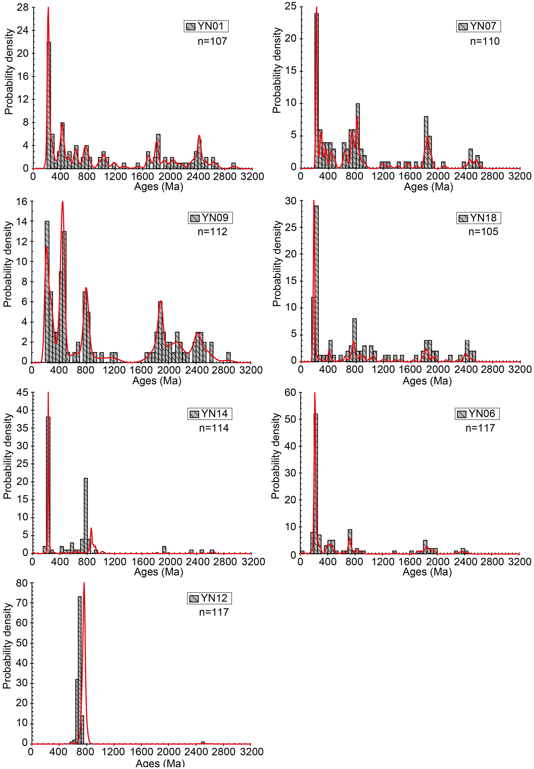
Figure 9. Distribution of detrital zircon U-Pb ages. Samples YN09, YN12, and YN07 were collected from the lacustrine layer, the lenticular sand within the conglomerates, and the fluvial sand overlying the lacustrine sediments at Haiziping, Luding, respectively; samples YN01 and YN06 were collected from the lacustrine sediments at Xichang and Mianning, respectively; sample YN14 is sand from the modern Dadu River; and sample YN18 is fluvial sand at the drainage divide in the village of Tuowu. Parameter n represents the number of analyzed concordant zircon grains used for the plots. The spectra of YN07, YN09, YN18, and YN01 are similar, with ages peaking at 250 Ma, 800 Ma, 1800 Ma, and 2500 Ma. The modern sand sample YN14 and sample YN06 lack paleo-Proterozoic zircons. YN12 displays a single peak at ca. 750 Ma, suggesting derivation from Mount Tianhaizi.
DISCUSSION
Formations of separate dammed lakes along the paleo-Dadu-Anning drainage
Cosmogenic nuclide burial dating shows that the lacustrine sediments in Luding were deposited 1.2 ± 0.3 Ma ago and the lacustrine sediments in Mianning were deposited ca. 0.6 Ma ago. These ages differ significantly from 2.6–4.2 Ma reported by Jiang et al. (Reference Jiang, Wu and Xiao1999), Wang et al. (Reference Wang, Zhao, Qiao and Jiang2006), and Yao et al. (Reference Yao, Zhao, Qiao, Li, Wang, Wang, Chen and Jiang2007) based on the magnetostratigraphic method. Two sets of paleomagnetic data were obtained for the Haiziping section, both show primarily normal polarity paleomagnetic signal with four layers of negative signal (Jiang et al., Reference Jiang, Wu and Xiao1999; Wang et al., Reference Wang, Zhao, Qiao and Jiang2006). For the Zhoujiadagou section in Mianning, only three layers of negative signal have been discovered (Yao et al., Reference Yao, Zhao, Qiao, Li, Wang, Wang, Chen and Jiang2007). However, there are problems with these sets of data: (1) samples with negative signal are of very limited numbers; (2) negative signals only occur in coarse-grained layers; (3) negative signals appear at different positions, or depths, in the same section from the two sets of data; (4) no paleontological constraints were obtained to confine the time interval of the paleomagnetic data. Thus, the paleomagnetic age for the Haiziping and Zhoujiadagou sections needs to be seriously reconsidered.
Based on the distribution of the Xigeda fluvial/lacustrine sediments, Kong et al. (Reference Kong, Granger, Wu, Caffee, Wang, Zhao and Zheng2009) suggested a large paleo-lake stretching 110 km from north to south and 160 km from east to west, formed as a result of a large landslide blocking the middle Yangtze River. Deng et al. (Reference Deng, Chew, Mark, Liu, Cogné, Jiang, Sullivan, Li and Li2020) argued for the existence of at least two large paleo-lakes at Panzhihua and Xichang. Although the detrital zircon U-Pb age distributions exhibit a similar material source for these fluvial/lacustrine sediments, the similar provenances are also consistent with the scenario that independent transient paleo-dammed lakes were filled with material carried by the integrated paleo-Dadu-Anning River.
In this study, three lacustrine samples for cosmogenic nuclide burial dating were collected from different elevations at the Luding section (Figs. 6, 7), and two samples were collected from the Mianning section with elevations at 1730 m and 1810 m. However, burial ages of the samples for each section overlap within 1σ errors. In addition, several fluvial/lacustrine samples of the Panzhihua section were dated previously with a large range of elevations (from 1058–1333 m; Kong et al., Reference Kong, Granger, Wu, Caffee, Wang, Zhao and Zheng2009). The burial ages also show a consistent result within errors. These results suggest that the Xigeda fluvial/lacustrine sediments formed from rapid accumulation. Some of these samples were collected near the bottoms of the sections (Fig. 7). Thus, the burial ages most likely represent the initial formation of the Xigeda paleo-lake, but not a continuous time-transgressive deposition. We propose that these fluvial/lacustrine sediments discontinuously occur at different regions deposited from separate transient paleo-dammed lakes, because: (1) the depositional ages differ significantly among these sediments—1.2 ± 0.3 Ma ago at Luding, ca. 0.6 Ma ago at Mianning, ca. 0.9 Ma ago at Xichang, and 1.6–1.3 Ma ago at Panzhihua (Kong et al., Reference Kong, Granger, Wu, Caffee, Wang, Zhao and Zheng2009); (2) the lacustrine sediments lie at different elevations—1800–2200 m near Luding, 1700–2000 m near Mianning, 1600–1650 m near Qionghai Lake, Xichang, and 970–1500 m continuously near Panzhihua; and (3) the redox states of the lacustrine sediments differ: the entire section of lacustrine sediments in Luding is khaki-colored visually (Fig. 2), both the Xichang and Panzhihua sections are light-yellow visually (Figs. 5C, D; Kong et al., Reference Kong, Granger, Wu, Caffee, Wang, Zhao and Zheng2009), whereas the Mianning section is dark-gray visually (Figs. 5A, B), suggesting reducing conditions. Therefore, considering that the Xigeda fluvial/lacustrine sediments were deposited during different periods, at different localities, and under different redox conditions, they should have formed in individual dammed lakes and were neither an isochronous nor a continuous stratigraphic unit.
The thickest section of the Xigeda fluvial/lacustrine sediments is located at Haiziping near Luding, with a thickness of ~441 m, which thins out markedly toward the south, indicating a heterogeneous distribution. In addition, landslide masses underneath the Xigeda lacustrine sediments have been identified on both sides of the modern Dadu River south of Luding County (Fig. 3). Therefore, the Xigeda sediments around Luding most likely originated from a dammed lake associated with a paleo-landslide, with the dam located near the villages of Daban and Shangsong (Fig. 3). Similarly, river blocking caused by the landslide was also widely discovered along the upper course of the Yangtze River (Xu, Reference Xu2011) and probably resulted in the formation of the Xigeda sediments around Panzhihua (Kong et al., Reference Kong, Granger, Wu, Caffee, Wang, Zhao and Zheng2009). In contrast, the deeply incised valley of the Anning River was considered to be a result of extensional deformation corresponding to post-orogenic collapse of the eastern margin of the Tibetan Plateau (Wang et al., Reference Wang, Burchfiel, Royden, Chen, Chen, Li and Chen1998; He et al., Reference He and Oguchi2008; Zhang et al., Reference Zhang, Li and Li2010). The extensional deformation, which caused the formation of the Anning graben, is defined by normal-fault boundaries. Therefore, the fluvial/lacustrine sediments at the Mianning and Xichang with a considerable number of interbedded layers associated with local landslides (Xu, Reference Xu2011) were most likely related to paleo-dammed lakes associated with the background of regional depressions.
The elevation of the modern Dadu River in Luding is ~1300 m. From the burial age and the elevation difference we obtained an incision rate of ~420 mm/kyr for the Dadu River. This value is within the range of 250–500 mm/kyr obtained for the Dadu and Yalong rivers based on U-Th/He dates, apatite fission track (Clark et al., Reference Clark, House, Royden, Whipple, Burchfiel, Zhang and Chen2005; Yang et al., Reference Yang, Suhail, Gourbet, Willett, Fellin, Lin and Gong2020), and 10Be concentrations in modern sands (Quimet et al., 2009). This value also is comparable with the regional uplift rate of 330 ± 30 mm/kyr for the entire Dadu River drainage since 12–15 Ma based on the stream-power incision model (Ma et al., Reference Ma, Zhang, Wang, Tao and Li2020). The similarity of incision rates for the Dadu and Yalong rivers lying on southeastern Tibet most likely suggests a unified river incision response to regional uplift.
Reorganization of the Dadu River
For comparison, the zircon U-Pb age distributions of the sands collected from the present-day Dadu and Anning rivers, and the fluvial/lacustrine sediments collected from the Luding, Mianning, Xichang, and Panzhihua sections representing the paleo-drainages, are shown in Figure 10. Previous studies of detrital zircons show that U-Pb ages of ca. 2500 Ma and ca. 1800 Ma are mainly derived from the Songpan-Ganzi flysch belt along the headwaters region of the modern Dadu River (Bruguier et al., Reference Bruguier, Lancelot and Malavieille1997; Weislogel, Reference Weislogel2008; Ding et al., Reference Ding, Yang, Cai, Pullen, Kapp, Gehrels and Zhang2013; He et al., Reference He, Zheng, Bookhagen and Clift2014), which are considered to be related to the amalgamation and breakup of a pre-Rodinian supercontinent, respectively (Zhai and Liu, Reference Zhai and Liu2003). Abundant zircons derived from widespread emplacement of volcanic rocks during the late Permian–Triassic are also found in upper reaches of the Dadu River (Fig. 1C). Additionally, as one of the major juvenile crustal additions and reconstructions, Neoproterozoic pre-rifting magmatism is widely developed along the western margin of the Yangtze Block, which currently is along the Anning River and downstream of the Dadu River (Fig. 1C). The breakup of the Rodinia supercontinent is regarded as the mechanism for the late stage (820–750 Ma) (Li et al., Reference Li, Li, Kinny, Wang, Zhang and Zhou2003), whereas the early stage (950–820 Ma) is related to an island arc setting. Along the modern Dadu and Anning drainages, the Neoproterozoic magmatic rocks are primarily composed of granulites, amphibolites, felsic gneisses, and gneiss granites with zircon ages of 721–864 Ma (Zhou et al., Reference Zhou, Yan, Kennedy, Li and Ding2002). Therefore, the zircon age spectra of YN07, YN09, YN18, YN06, YN01, and PAN07 indicate provenances from the Songpan-Ganzi flysch belt, Neoproterozoic complexes, and late Permian and Triassic granite plutons. The similarity in zircon age spectra among YN07, YN09, and YN18 (Figs. 9, 10) indicates that the fluvial sand sample YN18, taken from the drainage divide in Tuowu (Fig. 4), is indeed a remnant of the paleo-Dadu River.

Figure 10. Diagram showing the distribution of detrital zircon ages from the Xigeda lacustrine sediments at different sections (PAN07, YN09, YN07, YN01, and YN06), the sands of the modern Dadu and Anning rivers (YN14 and AN), and the fluvial sands of the drainage divide between them (YN18). The sequence of lines in Figure 10 is based on the sedimentation age. Each curve contains all analyses from a single sample. Parameter n represents the number of analyzed concordant zircon grains used in each plot. The age distribution of the fluvial/lacustrine sediments in the Panzhihua section refers to Kong et al. (Reference Kong, Granger, Wu, Caffee, Wang, Zhao and Zheng2009) and that of the modern Anning River refers to Yang et al. (Reference Yang, Suhail, Gourbet, Willett, Fellin, Lin and Gong2020). Vertical shaded bars show the main ages of zircons that would have been shed from various potential source regions. These age ranges have been compiled primarily from Bruguier et al. (Reference Bruguier, Lancelot and Malavieille1997), Zhou et al. (Reference Zhou, Yan, Kennedy, Li and Ding2002), Li et al. (Reference Li, Li, Kinny, Wang, Zhang and Zhou2003), Weislogel (Reference Weislogel2008), Ding et al. (Reference Ding, Yang, Cai, Pullen, Kapp, Gehrels and Zhang2013), He et al. (Reference He, Zheng, Bookhagen and Clift2014), and Xia et al. (Reference Xia, Xu, Niu and Liu2018).
The presence of relic sands of the Dadu River in Tuowu suggests that the paleo-Dadu River originally flowed southward through Tuowu into the Anning River. Compared with the sands of the modern Anning River with a major Neoproterozoic peak (AN in Fig. 10), the zircon age spectra of the Xigeda sediments along the Anning River exhibit a prominent peak at ca. 250 Ma (YN06 and YN01 in Fig. 10). This is different from the source signal of the Anning drainage, but similar to the sands taken from the modern Dadu River and the sediments of the Luding section. The multidimensional scaling (MDS) plots for comparison of detrital zircon signatures between the Xigeda lacustrine/fluvial sediments and selected provenances (Fig. 11) also suggest that the detrital zircon signatures of the relic sands in Tuowu and along the Anning River are similar to those of the modern Dadu River, further confirming that the paleo-Dadu River once flowed south and integrated with the Anning River so that the two rivers once shared similar provenances. Currently, the sands collected at the divide lie at ~2600 m. Uplift of the terrain in Tuowu (Clark et al., Reference Clark, Schoenbohm, Royden, Whipple, Burchfiel, Zhang, Tang, Wang and Chen2004; Yang et al., Reference Yang, Suhail, Gourbet, Willett, Fellin, Lin and Gong2020) forced the Dadu River to change its flow direction and flow eastward from Shimian. Compared with the lowest elevation of the lacustrine sediments in Luding, the terrain in Tuowu rose at least 800 m in the last 0.6 Ma. This gives an uplift rate of ≥1300 mm/kyr.
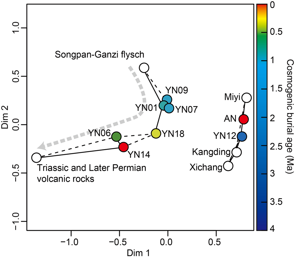
Figure 11. Two-dimensional multidimensional scaling plot of the fluvial/lacustrine sediments (color circles) along the Dadu and Anning rivers, and potential bedrock source units (hollow circles) (Bruguier et al., Reference Bruguier, Lancelot and Malavieille1997; Zhou et al., Reference Zhou, Yan, Kennedy, Li and Ding2002; Li et al., Reference Li, Li, Kinny, Wang, Zhang and Zhou2003; Weislogel, Reference Weislogel2008; Ding et al., Reference Ding, Yang, Cai, Pullen, Kapp, Gehrels and Zhang2013; He et al., Reference He, Zheng, Bookhagen and Clift2014; Xia et al., Reference Xia, Xu, Niu and Liu2018). Samples are colored according to cosmogenic nuclide burial age. Dissimilarity is based on the K-S statistic D value. The gray arrow shows the general trend with time.
With depositional ages decreasing, both zircon age peaks of ca. 2500 Ma and ca. 1800 Ma weaken gradually (Fig. 10). The samples indicate migration away from the provenance position of the Songpan-Ganzi flysch belt and closer to that of the Triassic and late Permian volcanic rocks (Fig. 11). The modern sand sample (YN14) in particular has the only ages peaking at 250 Ma and 800 Ma (Figs. 9, 10), and the absence of Paleoproterozoic zircons thus suggests that the modern Dadu River lost its headwaters stretching to the north of the Songpan-Ganzi Basin. Sample YN14 was collected from the lowest terrace of the Dadu River, which is 10 m above the current water level. Such a sampling strategy should eliminate any possible bias in zircon selection due to hydropower station construction since 1966 along the Dadu River. Because the U-Pb age spectra of YN06 and YN18 still show the signals of 1800 Ma and 2500 Ma, the modern Dadu River must have lost its headwaters within the last 0.6 Ma. Therefore, reorganization of the Dadu drainage at Shimian and progressive loss of the headwaters of the Dadu River should have occurred almost simultaneously within the last 0.6 Ma.
Tectonic implications
Both the elevated drainage divide and over-steepened gradients of the headstream of the Anning River suggest that capture of the paleo-Dadu-Anning River near Shimian (Figs. 12A−D) resulted from regional surface uplift since ca. 2.0 Ma (Clark et al., Reference Clark, Schoenbohm, Royden, Whipple, Burchfiel, Zhang, Tang, Wang and Chen2004; Yang et al., Reference Yang, Suhail, Gourbet, Willett, Fellin, Lin and Gong2020; Wang et al., Reference Wang, Liu, Zheng, Zhang, Yu, Pang, Li and Hao2021), which was completed within the last ca. 0.6 Ma, as determined by this study. Also, near Shimian, the Xianshuihe-Xiaojiang fault system turns from ~SE trending into ~N-S trending and splits into two major fault branches near the drainage divide—the Anninghe and Daliangshan faults (Fig. 12D). Both faults are characterized by a left-lateral slip with a dip-slip component (Wang et al., Reference Wang, Burchfiel, Royden, Chen, Chen, Li and Chen1998), complexly sharing an ~60 km left-lateral displacement to accommodate movement of the Xianshuihe-Xiaojiang fault system. Therefore, the drainage divide is located at the transition/bending zone along a large strike-slip fault, where it is apt to form a local surface uplift owing to the transpressional stress fields. With the regional surface uplift at the drainage divide associated with continuous strike-slip faulting, the southward flow of the paleo-Dadu-Anning River was gradually blocked (Figs. 12A, C) and subsequently was captured and redirected toward the east near Shimian (Figs. 12B, D).

Figure 12. Summary of stream captures for the paleo-Dadu-Anning River. (A) Suggested recovered paleo-Dadu-Anning River pattern before reversal and capture, ca. 0.6 Ma ago. (B) Present-day river pattern after suggested capture events. (C) Recovered paleo-Dadu River once flowed directly south into the paleo-Anning River, constituting a ~N-S integrated paleo-Dadu-Anning River before ca. 0.6 Ma. (D) After the suggested capture due to locally focused uplift, the paleo-Anning River had its headwaters cut off, and the Dadu River was redirected toward the east.
From the burial age and the elevation of the lacustrine sediments in Luding, we obtained an incision rate of 420 mm/kyr for the local area of the Dadu River. This value is similar to those previously obtained for the Dadu and Yalong rivers at ~30°N (Clark et al., Reference Clark, House, Royden, Whipple, Burchfiel, Zhang and Chen2005; Ouimet et al., Reference Ouimet, Whipple and Granger2009; Ma et al., Reference Ma, Zhang, Wang, Tao and Li2020; Yang et al., Reference Yang, Suhail, Gourbet, Willett, Fellin, Lin and Gong2020; Wang et al., Reference Wang, Liu, Zheng, Zhang, Yu, Pang, Li and Hao2021). Based on vertical profiles of low-temperature thermochronology, an exhumation rate or incision rate of ~100‒600 mm/kyr was derived for the Three Rivers region (Liu-Zeng et al., Reference Liu-Zeng, Zhang, McPhillips, Reiners, Wang, Pik and Zeng2018; Shen et al., Reference Shen, Braun and Yuan2022). For the low reaches of the Salween River, Gu et al. (Reference Gu, Xu, Lü, Aldahan and Lal2006) obtained incision rates of ~600 mm/kyr based on 10Be exposure dating of fluvial terraces. These results suggest that uplift of the middle segment of the Chuandian Block (26‒28°N latitude) occurred at rates similar to regions where the Dadu and Yalong rivers flow at ~30°N. The consistent surface-uplift rates for southeastern Tibet reflect regional uplift associated with crustal thickening. If we assume that the river-incision rate equals the surface-uplift rate, we can estimate the rate of crustal thickening as well as net crustal material inflow based on Airy isostatic equilibrium. Calculation shows the crustal thickening in areas of 26‒30°N at a rate of 2‒3 km/Myr.
The Xianhuihe-Xiaojiang fault is the most active fault in southeastern Tibet, with the Chuandian Rhombic Block exhibiting an increase southward in left-lateral strike-slip rate. Calculations based on GPS results and neotectonic deformation show that the left-slip rate is 12‒15 mm/yr for the Anninghe-Xiaojiang fault system (Y.Z. Wang et al., Reference Wang, Wang, Shen, Wang, Gan, Qiao and Meng2008), 10‒16 mm/yr for the segment from Kanding to Shimian (Y.Z. Wang et al., Reference Wang, Wang, Shen, Wang, Gan, Qiao and Meng2008; Bai et al., Reference Bai, Chevalier, Leloup, Li, Pan, Replumaz and Wang2021), ~10 mm/yr for the middle segment (Bai et al., Reference Bai, Chevalier, Pan, Replumaz, Leloup, Métois and Li2018), and 6‒8 mm/yr for the Ganzi and northern segments (Chevalier et al., Reference Chevalier, Leloup, Replumaz, Pan, Metois and Li2017). The land surface at altitude at ~30°N, from Batang, Litang, to Luding, measures ~4000 m asl, and the underlying crustal thickness is ~57 km (C.Y. Wang et al., Reference Wang, Lou, Lü, Wu, Chang, Dai, You, Tang, Zhu and Silver2008; Dong et al., Reference Dong, Shen and Qian2020). If the entire crust behaves coherently, the maximum net gain of crustal material from Kangding to the Xiaojiang fault, a distance of 400 km, will be (16–10) mm/yr × 57 km × 500 km = 0.17 km3/yr, considering a latitudinal width of 500 km. This value is much smaller than the material inflow calculated from the increase of crustal thickness, which is (2‒3) km/Myr × 400 km × 500 km = 0.4‒0.6 km3/yr. Such a mismatch suggests that the crust in southeast Tibet does not behave coherently so that the upper crust deformation is decoupled from the underlying weaker middle/lower crust in southeastern Tibet (Clark et al., Reference Clark, House, Royden, Whipple, Burchfiel, Zhang and Chen2005).
The tectonic uplift and rapid denudation since the late Miocene (5–12 Ma) were widely suggested by low-temperature thermochronology in eastern and southeastern Tibet (Clark et al., Reference Clark, Schoenbohm, Royden, Whipple, Burchfiel, Zhang, Tang, Wang and Chen2004; Wang et al., Reference Wang, Kirby, Furlong, van Soest, Shi, Kamp and Hodges2012; Zhang et al., Reference Zhang, Oskin, Liu-Zeng, Zhang, Reiners and Xiao2016; Ma et al., Reference Ma, Zhang, Wang, Tao and Li2020; Wang et al., Reference Wang, Liu, Zheng, Zhang, Yu, Pang, Li and Hao2021). Compared with the incision rate related to a longer history since the late Miocene, the millennial incision rates obtained by Ouimet et al. (Reference Ouimet, Whipple and Granger2009) and this study and are consistent, implying that such a mechanical decoupling passing through the region of ~30°N likely occurred since 12–5 Ma.
Several models previously have been proposed to explain the geodynamics of the stream network reorganization that occurred in southeastern Tibet, including lateral extrusion of the Chuandian Block along large crustal-shearing faults (Leloup et al., Reference Leloup, Arnaud, Lacassin, Kienast, Harrison, Phan Trong, Replumaz and Tapponnier2001), gravitational spreading of the elevated crustal material (Copley, Reference Copley2008), and dynamic channel flow within the lithosphere or asthenosphere (Clark and Royden, Reference Clark and Royden2000; Shi et al., Reference Shi, Wang, Sieh, Weldon, Feng, Chan and Liu-Zeng2017). Based on the results in this study, these driving forces are not mutually exclusive and probably together resulted in a regional river network rearrangement associated with locally focused uplift. Particularly in southeastern Tibet, lateral rotation around the eastern Himalaya Syntaxis and extrusion of the Chuandian Block were largely decoupled from the kinematics of the middle/lower crust, causing formation of several large strike-slip fault systems, such as the Dali fault system, Xiaojiang fault system, and Xianshuihe fault system. As a result, these large-scale fault systems, which once transected the elevated planation into locally focused uplifts and depressions, consequently caused frequent paleo-drainage changes during the Pleistocene.
CONCLUSIONS
The geometry and evolution of fluvial systems are commonly found to be good proxies for crustal deformation processes and their related geodynamic mechanisms. Fluvial/lacustrine sediments with thicknesses of hundreds of meters are widely distributed along and above the present-day Dadu and Anning drainages in southeastern Tibet, providing sedimentary records of regional river network reorganization associated with late Cenozoic tectonic activities. Based on provenance analysis and cosmogenic nuclide burial dating, we reached three major conclusions.
First, based on cosmogenic nuclide burial dating, lacustrine sediments at the Luding, Mianning, and Xichang sections were deposited ca. 1.2 Ma ago, ca. 0.6 Ma ago, and ca. 0.9 Ma ago from north to south, respectively. The distinct ages and depositional environments of these sediments along the Dadu, Anning, and Yangtze rivers argue against the existence of a single contemporaneous lake in this area.
Second, detrital zircon U-Pb age distributions confirm that the fluvial sands at the drainage divide and the Xigeda sediments along the Anning River are the remnants of the paleo-Dadu River. Thus, the paleo-Dadu River originally flowed southward into the Anning River. Compared with the paleo-Dadu River, the modern sands of the Dadu River lack zircons with U-Pb ages of 1800 Ma and 2500 Ma, which are derived from north of the Songpan-Ganzi Basin. Reorganization of the Dadu drainage and progressive loss of the headwaters of the Dadu River must have occurred within the last 0.6 Ma.
Third, over a million-year time scale, matching of material gain calculated from crustal thickening and slip-rates of surface faulting implies mechanical decoupling of the upper and middle/lower parts of the crust. The locally focused uplift driving rearrangement of the paleo-Dadu River also appears to be related to the compressional bending associated with Xianshuihe-Xiaojiang sinistral strike-slip faulting. Therefore, we propose that drainage reorganization in southeastern Tibet is related to a combination of several geodynamic processes, corresponding to the progressive convergence between the India and Eurasian plates.
Supplementary Material
The supplementary material for this article can be found at https://doi.org/10.1017/qua.2022.71
Financial Support
This work was financially supported by the Natural Science Foundation of China (41941016; 42072240; 41830217), the Key Special Project for Introduced Talents Team of the Southern Marine Science and Engineering Guangdong Laboratory (GML2019ZD0201), the Second Tibetan Plateau Scientific Expedition and Research Program (2019QZKK0901), the Special Fund of the Institute of Geophysics, China Earthquake Administration (DQJB20B21), and China Geological Survey (DD20221630).


