


Impact statement
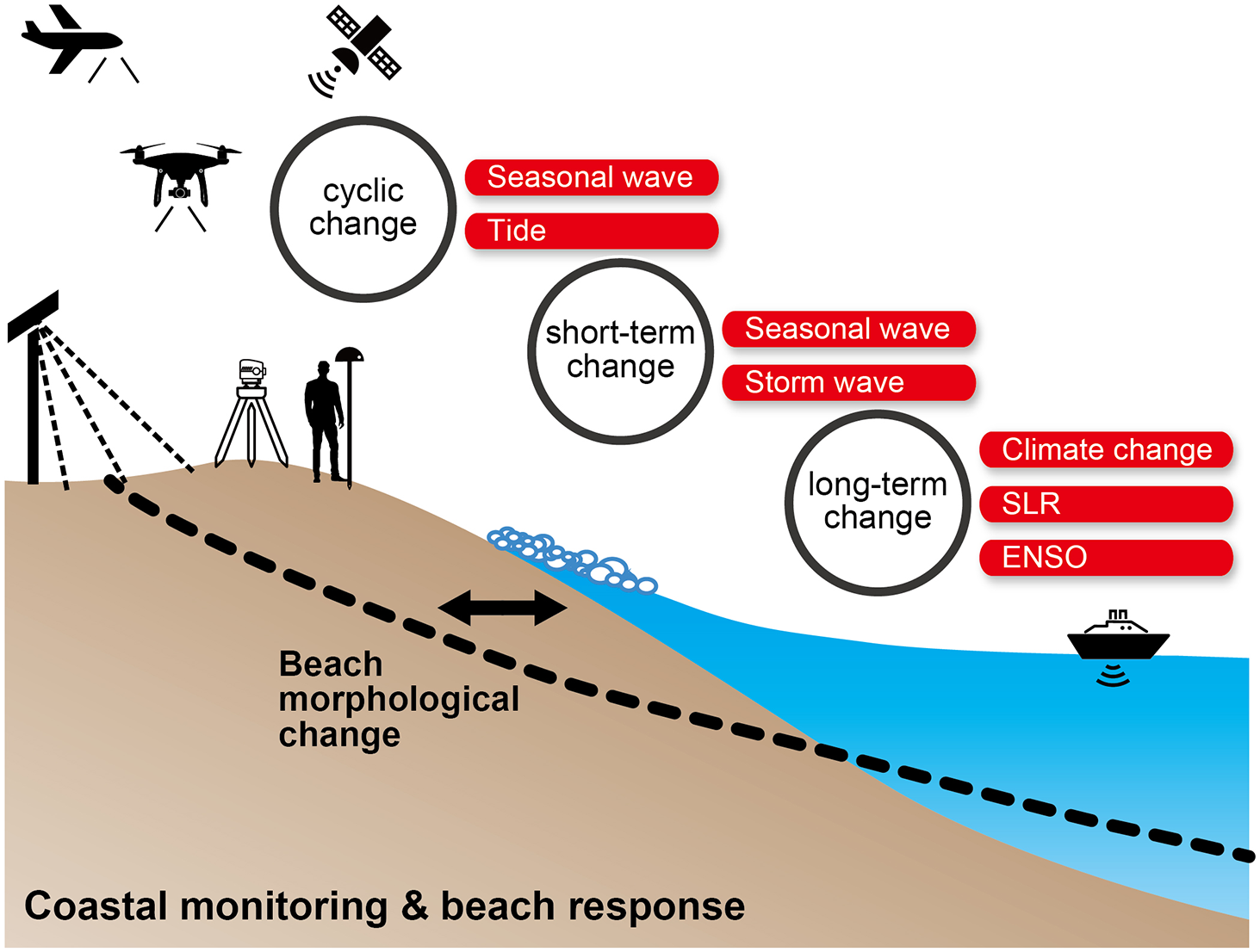
Beaches play an important role in disaster prevention by reducing the wave energy reaching land and protecting hinterlands from wave overtopping and other hazards. Using various methods, scientists have monitored beach morphology to investigate how and by what mechanism beach morphology changes. For example, long-term in situ monitoring data of beach morphology, obtained using methods such as leveling and satellite-based positioning, have provided insight into beach morphological processes on various time scales. Temporary erosion caused by storms and cyclic morphological changes caused by seasonal wave fluctuations have been well studied; however, certain processes, such as the effects of tidal and wave interactions on beach morphological change and the response to sea level rise, remain unresolved. High-quality multisite monitoring data acquired by new surveying methods, such as drones and LiDAR (light detection and ranging), will provide clues that will help elucidate these processes.
Introduction
Sandy beach morphology is changed continuously by waves, currents, and winds. The variability of beach morphology is one of the important processes in geophysics, and knowledge of the underlying processes is important for coastal disaster prevention. The foreshore, that is, the swash zone, is the area that changes most dynamically in response to the wave regime. Erosion of the foreshore can lead to large-scale shoreline retreat; therefore, foreshore morphology should be monitored carefully from the perspective of coastal management. To capture the processes underlying foreshore morphological change, in situ monitoring data of beach morphology are indispensable, and thus many beach monitoring campaigns have been performed worldwide.
Monitoring of beach morphology, including not only the foreshore but also the upper shoreface (i.e., the surf zone and shallower than the wave base), is mandatory in investigating foreshore morphological changes. Especially for long-term beach processes such as shoreline change due to sea level rise (SLR) and sediment transport caused by extreme storms once every few decades, the sediment transport and deposition processes between the lower and upper shoreface cannot be ignored (Anthony and Aagaard, Reference Anthony and Aagaard2020; Harley et al., Reference Harley, Masselink, Ruiz de Alegría-Arzaburu, Valiente and Scott2022). Most beach monitoring campaigns focus on the backshore to upper shoreface zone, while the lower shoreface is rarely monitored adequately.
Campaigns for monitoring beach morphology can be divided broadly into two categories. The first is short-term and high-frequency or high-resolution monitoring, which mainly focuses on the morphological changes caused by cross-shore sediment transport. We call such campaigns concentrated monitoring. The monitoring usually involves a single or a limited number of cross-shore transects, and the beach profile is measured to reveal the changes that occur over a period of a few days to a few weeks during storm and calm wave conditions. Short-term monitoring campaigns often target foreshore morphological changes that are substantial even over short periods. Generally, in such monitoring campaigns, beach profiles are measured using leveling, RTK-GNSS (real-time kinematic global navigation satellite system) (Harley et al., Reference Harley, Turner, Short and Ranasinghe2011a), and more recently, LiDAR techniques (Almeida et al., Reference Almeida, Masselink, Russell, Davidson, Poate, McCall, Blenkinsopp and Turner2013; O’Dea et al., Reference O’Dea, Brodie and Hartzell2019; Phillips et al., Reference Phillips, Blenkinsopp, Splinter, Harley and Turner2019).
The second category is long-term and low-frequency or low-resolution monitoring, which focuses on morphological changes caused by both cross-shore and longshore sediment transport. The monitoring usually involves obtaining a shoreline position of the entire coast and extensive three-dimensional bathymetry. Morphological changes due to beach rotation (Klein et al., Reference Klein, Benedet and Schumacher2002) and quantitative imbalance of longshore sediment transport around jetties, which can occur coastwide on monthly–multiyear scales, can be obtained. In a situation where external factors such as the wave regime or the sediment supply from a river could change on annual–decadal scales (Warrick et al., Reference Warrick, Bountry, East, Magirl, Randle, Gelfenbaum, Ritchie, Pess, Leung and Duda2015; Nguyen and Takewaka, Reference Nguyen and Takewaka2022), the object of monitoring might be to determine the long-term morphological changes due to cross-shore and longshore sediment transport. In some cases, such as in the Netherlands, a national strategy has promoted continued long-term annual monitoring of beach profiles on the national scale (i.e., the Jarkus program; e.g., Southgate, Reference Southgate2011). Satellite imagery and aerial photos are often used to observe long-term shoreline changes (Crowell et al., Reference Crowell, Leatherman and Buckley1991; Luijendijk et al., Reference Luijendijk, Hagenaars, Ranasinghe, Baart, Donchyts and Aarninkhof2018), and camera measurements such as Argus are also used to analyze short-term variations (Holman et al., Reference Holman, Sallenger, Lippmann and Haines1993; Harley and Kinsela, Reference Harley and Kinsela2022). Single-beam sonar and more recently narrow multibeam sonar mounted on boats are generally used to produce precise bathymetric maps over large areas (Barnard et al., Reference Barnard, Erikson and Kvitek2011), although the frequency of such monitoring is often as low as once per year.
On the basis of the above, it would be pertinent to ask whether there are any long-term high-frequency observations that could fill the gap between the two types of monitoring campaign. The answer to that question would be yes. Long-term and high-frequency monitoring is also important. Even though wave conditions might not change over long periods of time, beaches often show long-period fluctuations in morphology, suggesting that the nonlinearity of short-period beach responses could drive long-term beach changes. However, the nonlinearity is so small that limited short-term high-frequency observations cannot fully reveal the underlying processes. Here, we summarize the relation between the monitoring cost per unit area, and the accuracy and resolution (or volume of information) of each monitoring method (Figure 1). The latest technologies such as airborne LiDAR and multibeam sonar combined with GNSS can provide large volumes of high-quality data with high accuracy; however, they are unsuitable for long-term high-frequency monitoring campaigns owing to their high operational costs. Conversely, satellite imagery and Argus photos are low cost and are suitable for long-term observations. However, the information obtained from such images is often limited to shoreline position, and the temporal or spatial resolution is not always adequate. Positioned between the two in Figure 1, RTK-GNSS, leveling, and single-beam sonar attached to a jet ski are techniques unsuitable for monitoring of large areas, but they can be used to obtain high-accuracy data over a limited area. These methods can be used for long-term high-frequency observations if certain costs are borne. Recently, automatic observations of the zone from dunes to the foreshore have been obtained by fixed LiDAR and photogrammetry using UAVs (unmanned aerial vehicles) (Turner et al., Reference Turner, Harley, Short, Simmons, Bracs, Phillips and Splinter2016), which represents a recent major development in beach monitoring with reduced costs and improved accuracy, although challenges remain with regard to surveying underwater areas. There is no doubt that long-term, high-frequency, and high-resolution in situ monitoring of beach morphology can be realized only at great cost. Consequently, long-term beach profile monitoring campaigns are very limited worldwide owing to the constraints of human and financial resources.
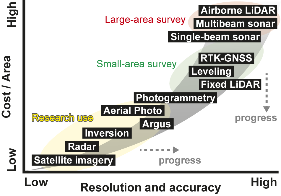
Figure 1. Relationship between cost and information of beach survey methods.
Representative beach monitoring campaigns that have obtained relatively high-frequency (i.e., more than bimonthly) beach profiles for more than 15 years have been conducted at Narrabeen, Australia (Short and Trenbanis, Reference Short and Trenbanis2004; Harley et al., Reference Harley, Turner, Short and Ranasinghe2011a; Turner et al., Reference Turner, Harley and Drummond2016), Moruya, Australia (Thom and Hall, Reference Thom and Hall1991; McLean and Shen, Reference McLean and Shen2006; Tamura et al., Reference Tamura, Oliver, Cunningham and Woodroffe2019), Hasaki, Japan (Banno et al., Reference Banno, Nakamura, Kosako, Nakagawa, Yanagishima and Kuriyama2020), Omotehama, Japan (Kato et al., Reference Kato, Okabe and Sawahara2013), Duck, USA (Lippmann and Holman, Reference Lippmann and Holman1990; Larson and Kraus, Reference Larson and Kraus1994; Nicholls et al., Reference Nicholls, Birkemeier and Lee1998), Torrry Pines, USA (Ludka et al., Reference Ludka, Guza, O’Reilly, Merrifield, Flick, Bak, Hesser, Bucciarelli, Olfe, Woodward, Boyd, Smith, Okihiro, Grenzeback, Parry and Boyd2019), Ocean Beach, USA (Yates et al., Reference Yates, Guza, O’Reilly, Hansen and Barnard2011; Splinter et al., Reference Splinter, Turner, Davidson, Barnard, Castelle and Oltman-Shay2014), Truc Vert, France (Castelle et al., Reference Castelle, Bujan, Marieu and Ferreira2020), and Porsmilin, France (Bertin et al., Reference Bertin, Floc’h, Le Dantec, Jaud, Cancouët, Franzetti, Cuq, Prunier, Ammann, Augereau, Lamarche, Belleney, Rouan, David, Deschamps, Delacourt and Suanez2022). In these long-term in situ monitoring campaigns, beach profiles along one or several limited transects are measured using techniques such as GNSS. Although the depths and elevations of the offshore and landward boundaries vary among campaigns, most of the monitoring campaigns at least cover the foreshore area. Long-term campaigns that have been conducted bimonthly (or more frequently), which include various beach morphological changes such as abrupt large erosion during periods of high waves and gradual accretion during periods of low waves, provide very valuable information. Based on such monitoring data, numerical models have been developed to reproduce the morphological changes of the foreshore, and associated beach morphological change processes have been investigated. In this paper, we review the various foreshore beach processes that operate on multiple time scales due to cross-shore sediment transport that have been elucidated through long-term beach monitoring, and we discuss the scientific knowledge that we can expect to obtain in the future through further development of techniques for monitoring beach morphology and continued long-term monitoring campaigns.
In studies on foreshore morphological changes, cross-shore position with a specific elevation is often used as a proxy for beach morphology (Boak and Turner, Reference Boak and Turner2005). It is called the shoreline position and is defined with a specific elevation, such as the height of mean high-water springs (MHWS), which retreats during erosion and advances during accretion. When the morphological change of an entire foreshore is targeted, multiple reference heights are used for shoreline positions. Thus, shoreline changes and foreshore morphological changes are almost synonymous in terms of the definition.
Cyclic foreshore beach processes revealed by observations
The usefulness of long-term high-frequency monitoring data is highlighted in periodicity analyses of short-term (less than 1 year) foreshore morphological changes. Spectral analysis revealed cyclic shoreline changes with 1-year and 6-month cycles at Hasaki, Japan (Banno and Kuriyama, Reference Banno and Kuriyama2020), which are caused by cross-shore sediment transport related to seasonal fluctuations in waves (Eichentopf et al., Reference Eichentopf, Alsina, Christou, Kuriyama and Karunarathna2020). Conversely, data recorded at Narrabeen, where high-frequency morphological changes have also been monitored, showed no clear seasonal variation in the mean shoreline position (Lazarus et al., Reference Lazarus, Harley, Blenkinsopp and Turner2019). This is probably attributable to the fact that the incident wave energy at Narrabeen does not show clear cyclic variation, such as a 1-year cycle, and because of the relatively large influence of morphological changes induced by longshore sediment transport such as beach rotation (Harley et al., Reference Harley, Turner, Short and Ranasinghe2011b; Harley et al., Reference Harley, Turner and Short2015) associated with seasonal changes in the direction of incoming waves. In the case of substantial impacts such as longshore sediment transport and sediment budget changes, the importance of long-term high-frequency monitoring data increases because large volumes of data are required for statistical extraction of the morphological changes caused by cross-shore sediment transport.
A recent study using a large volume of monitoring data revealed a foreshore beach process previously masked by variations in other factors. The process is affected by tidal fluctuations. The study revealed that a large tidal range during spring tides and king tides (Flick, Reference Flick2016) makes erosion of the upper swash zone more likely, even within the same wave regime (Banno and Kuriyama, Reference Banno and Kuriyama2020). Several monitoring studies showed that beach elevation of a few meters above the mean water level was minimal a few days after the spring tide (LaFond, Reference LaFond1939; Aubrey et al., Reference Aubrey, Inman and Nordstrom1976; Clarke et al., Reference Clarke, Eliot and Frew1984). However, the effect of the primary underlying beach process could not be distinguished from other effects, such as waves, because of limited available data and thus full explanation of the beach process was not proposed. In relation to this process induced by tidal fluctuations, sediment transport and the morphological changes even between a single tide, that is, between rising and falling tides, might be affected by infiltration and exfiltration of water on the beach face (Duncan, Reference Duncan1964; Clarke and Eliot, Reference Clarke and Eliot1987; Butt et al., Reference Butt, Russell and Turner2001; Masselink and Li, Reference Masselink and Li2001; Coco et al., Reference Coco, Burnet, Werner and Elgar2004). However, beach processes on the hourly scale have not yet been clarified because of lack of long-term morphological change data monitored at intervals of less than 1 day, for example, 6 h, which is the time scale of ebb and flood tides.
Daily–annual-scale foreshore beach processes revealed by observations
For time scales of less than 1 year, as shown by the seasonal cycle in the spectra of beach monitoring data, it has long been known that a shoreline will advance and retreat seasonally owing to seasonal wave fluctuations (e.g., Shepard, Reference Shepard1950). When waves are calm, sediment is transported onshore by sheet flow and accreted over a period of days. Conversely, when waves are large during storms, erosion can occur in just a few days (sometimes only a few hours) with sediment transported offshore via suspension. On many beaches, wave characteristics vary seasonally, and the foreshore accretes with a well-developed berm during seasons with frequent periods of calm waves and retreats with a relatively gradual slope during seasons with frequent periods of high waves.
Equilibrium-based shoreline change models are used widely to estimate short–long-term accretion and erosion, such as that over daily–multiyear periods including seasonal variation (Miller and Dean, Reference Miller and Dean2004; Yates et al., Reference Yates, Guza and O’Reilly2009, Reference Yates, Guza, O’Reilly, Hansen and Barnard2011; Davidson et al., Reference Davidson, Splinter and Turner2013; Turki et al., Reference Turki, Medina, Coco and Gonzalez2013; Castelle et al., Reference Castelle, Marieu, Bujan, Ferreira, Parisot, Capo, Sénéchal and Chouzenoux2014; Splinter et al., Reference Splinter, Turner, Davidson, Barnard, Castelle and Oltman-Shay2014; Banno et al., Reference Banno, Kuriyama and Hashimoto2015; Jara et al., Reference Jara, González and Medina2015; Dean and Houston, Reference Dean and Houston2016; Vitousek et al., Reference Vitousek, Barnard, Limber, Erikson and Cole2017; Lemos et al., Reference Lemos, Floc’h, Yates, Le Dantec, Marieu, Hamon, Cuq, Suanez and Delacourt2018; Chataigner et al., Reference Chataigner, Yates, Le Dantec, Suanez, Floch, Bouvard, Leary, Petton and Cailler2020; D’Anna et al., Reference D’Anna, Idier, Castelle, Le Cozannet, Rohmer and Robinet2020, Reference D’Anna, Castelle, Idier, Rohmer, Le Cozannet, Thieblemont and Bricheno2021a,Reference D’Anna, Idier, Castelle, Vitousek and Le Cozannetb; Montaño et al., Reference Montaño, Coco, Antolínez, Beuzen, Bryan, Cagigal, Castelle, Davidson, Goldstein, Ibaceta, Idier, Ludka, Masoud-Ansari, Méndez, Murray, Plant, Ratliff, Robinet, Rueda, Sénéchal, Simmons, Splinter, Stephens, Townend, Vitousek and Vos2020). A beach will approach a theoretical equilibrium profile, on which no further morphological change is caused, when subjected to the same wave regime for an extended period. Equilibrium-based shoreline change models are based on the concept of the equilibrium profile determined by waves. In such numerical models, shoreline change is determined by the imbalance of the actual position of the shoreline relative to the equilibrium shoreline position. The advantage of such models is that beaches where substantial erosion has already occurred will not experience further notable erosion (Eichentopf et al., Reference Eichentopf, Alsina, Christou, Kuriyama and Karunarathna2020). Consequently, the long-term robustness of equilibrium-based shoreline change models is high because simulation results tend not to diverge unrealistically but fluctuate around the equilibrium shoreline position; thus, such models are often used for long-term hindcasts and forecasts.
Equilibrium-based shoreline change models have been used to reproduce shoreline changes over periods of several years relatively well (e.g., Yates et al., Reference Yates, Guza and O’Reilly2009; Splinter et al., Reference Splinter, Turner, Davidson, Barnard, Castelle and Oltman-Shay2014). The temporal resolution of the estimated shoreline changes depends largely on the monitoring data used to calibrate the model; therefore, in many cases, such simulations are limited to reproduction of only seasonal change. When using high-frequency beach monitoring data for calibration, such as the daily data obtained at Hasaki and the biweekly data acquired at Narrabeen, short-term erosion over a period of a few days can be estimated (e.g., Davidson et al., Reference Davidson, Splinter and Turner2013; Splinter et al., Reference Splinter, Turner, Davidson, Barnard, Castelle and Oltman-Shay2014; Banno et al., Reference Banno, Kuriyama and Hashimoto2015).
Even when using high-frequency shoreline change data for calibration, the estimated temporal resolution might not always be high depending on the tuning of the model parameters (Montaño et al., Reference Montaño, Coco, Antolínez, Beuzen, Bryan, Cagigal, Castelle, Davidson, Goldstein, Ibaceta, Idier, Ludka, Masoud-Ansari, Méndez, Murray, Plant, Ratliff, Robinet, Rueda, Sénéchal, Simmons, Splinter, Stephens, Townend, Vitousek and Vos2020). Parameter tuning can be classified into two methods: minimizing the error with respect to the observed shoreline position and minimizing the error with respect to the amount of shoreline change. In most studies, the former method is adopted because it is most likely to reduce the overall error; however, it tends to reproduce trends without reproducing fine-scale high-resolution temporal variation. The latter method is more likely to reproduce short-term variations, but it does not account for shoreline position errors; consequently, the resulting output of estimated shoreline positions might differ substantially from the measured shoreline positions. We have not found any studies that even discuss the above calibration methods, even though selection of the method adopted depends on the purpose for which the model will be used.
Annual–decadal-scale foreshore beach processes revealed by observations
Beach morphological changes over long time scales are often discussed in the context of global climate change. Using long-term beach monitoring data, coastal responses to atmospheric and oceanic variations such as the El Niño–Southern Oscillation (ENSO), which varies on the scale of a few years, have been investigated (Barnard et al., Reference Barnard, Short, Harley, Splinter, Vitousek, Turner, Allan, Banno, Bryan, Doria, Hansen, Kato, Kuriyama, Randall-Goodwin, Ruggiero, Walker and Heathfield2015). Beach morphological monitoring data along 48 coasts of the Pacific Rim revealed different responses to the impact of ENSO in different locations. For example, erosion is greater along the California coast (e.g., Ocean Beach) and Japanese coast (e.g., Hasaki) facing the Pacific Ocean in winter when El Niño events occur, while erosion is greater in Australia (e.g., Narrabeen) in winter when La Niña events occur. It has been suggested that the impact on erosion is caused by waves and sea level variations affected by ENSO. Relationships between atmospheric and oceanic variations and waves have been indicated by the high correlation of atmospheric pressure patterns and climate indices with the variations of waves (Castelle et al., Reference Castelle, Dodet, Masselink and Scott2017; Kishimoto et al., Reference Kishimoto, Shimura, Mori and Mase2017), which consequently also influence shoreline variations (Kuriyama et al., Reference Kuriyama, Banno and Suzuki2012; Robinet et al., Reference Robinet, Castelle, Idier, Cozannet, Déqué and Charles2016). Studies at Hasaki (Kuriyama et al., Reference Kuriyama, Banno and Suzuki2012) and Truc Vert (Robinet et al., Reference Robinet, Castelle, Idier, Cozannet, Déqué and Charles2016) showed that 45% and 70% of long-term shoreline variability can be explained by teleconnections of large-scale atmospheric and oceanic variability, respectively. Another study reported that the 18.6-year nodal tidal cycle causes shoreline retreat (Gratiot et al., Reference Gratiot, Anthony, Gardel, Gaucherel, Proisy and Wells2008); however, the response of beach morphological change to long-term sea level change with such periodicity has not yet been fully investigated using a sufficient volume of long-term monitoring data.
The Bruun rule (Bruun, Reference Bruun1962), which determines the probable amount of future shoreline retreat associated with a shift of the equilibrium beach profile with SLR, is widely used. In terms of the concept, a rising sea level is expected to cause foreshore erosion and offshore sediment transport near the foreshore. It has been highlighted that this method enforces many assumptions (Cooper and Pilkey, Reference Cooper and Pilkey2004) and is susceptible to the setting of parameters such as closure depth (Udo et al., Reference Udo, Ranasinghe and Takeda2020) and that it might not always match actual morphological changes (Ranasinghe et al., Reference Ranasinghe, Callaghan and Stive2012). In historical beach monitoring data, the effect of SLR per unit time on cross-shore sediment transport is very small in comparison with the morphological changes caused by wave variations and longshore sediment transport. Therefore, the validity of the Bruun rule and the details of actual coastal response to SLR remain unknown. The effects of SLR on beach morphological changes are currently being investigated in laboratory experiments that simulate SLR as close as possible to actual scale, while controlling all other external forces (Atkinson et al., Reference Atkinson, Baldock, Birrien, Callaghan, Nielsen, Beuzen, Turner, Blenkinsopp and Ranasinghe2018; Atkinson and Baldock, Reference Atkinson and Baldock2020), and in analysis of shoreline changes exposed to hypothetical SLR where land subsidence is important (Nguyen and Takewaka, Reference Nguyen and Takewaka2020). The current solution is to couple the Bruun rule with an equilibrium-based shoreline change model. Long-term shoreline predictions have been simulated using this approach by incorporating the shoreline retreat predicted by the Bruun rule (Vitousek et al., Reference Vitousek, Barnard, Limber, Erikson and Cole2017; D’Anna et al., Reference D’Anna, Idier, Castelle, Le Cozannet, Rohmer and Robinet2020, Reference D’Anna, Castelle, Idier, Rohmer, Le Cozannet, Thieblemont and Bricheno2021a), and by introducing the Bruun rule directly into the term representing the equilibrium shoreline position in the model (Banno et al., Reference Banno, Kuriyama and Hashimoto2015; D’Anna et al., Reference D’Anna, Idier, Castelle, Vitousek and Le Cozannet2021b).
Long-term shoreline changes are also expected to occur in response to long-term changes in wave climate. Therefore, it is important to determine whether we reproduce long-term shoreline change on annual–decadal scales using equilibrium-based shoreline change models. A recent study using multiple equilibrium-based shoreline change models hindcasted shoreline change over 15 years and predicted blind shoreline change over 3 years for Tairua beach, New Zealand (Montaño et al., Reference Montaño, Coco, Antolínez, Beuzen, Bryan, Cagigal, Castelle, Davidson, Goldstein, Ibaceta, Idier, Ludka, Masoud-Ansari, Méndez, Murray, Plant, Ratliff, Robinet, Rueda, Sénéchal, Simmons, Splinter, Stephens, Townend, Vitousek and Vos2020). Long-term hindcasts (past 22 years) and scenario projections (future 88 years) of shoreline change have been calculated for Hasaki, Japan (Banno and Kuriyama, Reference Banno and Kuriyama2014; Banno et al., Reference Banno, Kuriyama and Hashimoto2015). In both studies, the observed long-term shoreline variability (type of long-term trend) could not be reproduced adequately, leading to deterioration of the overall reproduction accuracy (i.e., R 2 and RMSE (root-mean-square error)). Whether this observed long-term shoreline variation is caused by wave climate change or by other processes remains a matter of debate, but current shoreline change models are limited in terms of their skill in reproducing and predicting long-term shoreline variation. In forecasting applications, equilibrium-based shoreline change models use unique parameters determined from observational data. Thus, the simulated shoreline position tends to be near the mean shoreline position, and reproducibility and prediction skill are diminished when forced with nonstationary wave conditions over time (Ibaceta et al., Reference Ibaceta, Splinter, Harley and Turner2020), such as wave climate changes due to global warming. It has also been suggested that beach response could be affected in the long-term by substantial erosion due to extreme storms (Kuriyama and Yanagishima, Reference Kuriyama and Yanagishima2018). Although foreshore morphological change is also affected by the effects of wave breaking by longshore bars (Kuriyama and Banno, Reference Kuriyama and Banno2016), which move and develop on a multiyear scale (Ruessink et al., Reference Ruessink, Wijnberg, Holman, Kuriyama and van Enckevort2003, Reference Ruessink, Kuriyama, Reniers, Roelvink and Walstra2007), these effects are not introduced into equilibrium-based shoreline change models. In practice, there is a dilemma regarding incorporation of the effects of longshore bars into shoreline change models because prediction of longshore bars has yet to be fully accomplished. Although process-based models such as XBeach (Roelvink et al., Reference Roelvink, Reniers, van Dongeren, van Thiel de Vries, McCall and Lescinski2009) and DELFT3D (Lesser et al., Reference Lesser, Roelvink, van Kester and Stelling2004), which include calculations of wave deformation and dissipation, are effective in simulating detailed coastal processes, producing long-term forecasts over periods of more than a few months remains challenging (Hanson et al., Reference Hanson, Aarninkhof, Capobianco, Jim’enez, Larson, Nicholls, Plant, Southgate, Steetzel, Stive and de Vriend2003). Nevertheless, application of process-based models to long-term forecasting has been studied (Davidson, Reference Davidson2021). An approach to long-term forecasting in response to wave fluctuations and SLR, which combines a process-based model and a probabilistic method, has also been studied (Ranasinghe et al., Reference Ranasinghe, Callaghan and Stive2012; Dastgheib et al., Reference Dastgheib, Martinez, Udo and Ranasinghe2022). Currently, a reasonable simple solution is to account for the uncertainties in hindcasts and forecasts by Monte Carlo simulations (Banno and Kuriyama, Reference Banno and Kuriyama2014) or by ensembles of multiple models (Montaño et al., Reference Montaño, Coco, Antolínez, Beuzen, Bryan, Cagigal, Castelle, Davidson, Goldstein, Ibaceta, Idier, Ludka, Masoud-Ansari, Méndez, Murray, Plant, Ratliff, Robinet, Rueda, Sénéchal, Simmons, Splinter, Stephens, Townend, Vitousek and Vos2020). Original wave monitoring and prediction data also contain uncertainty, and the uncertainty of wave data should be considered, for example, using Monte Carlo simulations (Chataigner et al., Reference Chataigner, Yates, Le Dantec, Harley, Splinter and Goutal2022) or ensembles of wave conditions (Vitousek et al., Reference Vitousek, Cagigal, Montaño, Rueda, Mendez, Coco and Barnard2021).
As described above, reasonably adequate knowledge of foreshore morphological changes on time scales of a few days to a few years has been obtained from long-term beach monitoring data. However, we need further monitoring data to investigate foreshore morphological changes on time scales shorter than a day and longer than several years.
Monitoring future
The development of monitoring methods will provide new insights into beach morphological changes and processes. The cost per surveyed area of state-of-the-art equipment such as LiDAR will gradually decrease through technological innovation and more efficient manufacturing, and the accuracy, resolution, and volume of information obtained from monitoring method using satellite imagery and Argus photos will improve as research progresses. In recent years, miniaturized LiDAR scanners that can be mounted on UAVs have reduced the cost of using large airborne platforms. Efficient collection of beach morphological data by combining sonar with autonomous underwater vehicles and other remotely operated vehicles is also expected to be adopted for long-term monitoring in the future. Additionally, estimation of bathymetry using satellite techniques, such as synthetic aperture radar imagery (Pleskachevsky et al., Reference Pleskachevsky, Lehner, Heege and Mott2011; Capo et al., Reference Capo, Lubac, Marieu, Robinet, Bru and Bonneton2014) and inverse estimation of bathymetry from video recordings of waves (Matsuba and Sato, Reference Matsuba and Sato2018), have recently been investigated, and the resolution and accuracy of such approaches will improve over coming years. It is expected that long-term ultra-high-frequency monitoring data will become more readily available in the future following these developments, and we anticipate that easier acquisition of such data will allow enhanced monitoring of beach morphology.
For example, if beach profiles were observed over a long period at intervals of several hours using automatic instruments such as LiDAR with a green laser (e.g., Pastol, Reference Pastol2011), it might be possible to quantify the effects of tides on beach morphological changes during flood and ebb tides, as suggested by Phillips et al. (Reference Phillips, Blenkinsopp, Splinter, Harley and Turner2019) and Banno and Kuriyama (Reference Banno and Kuriyama2020). Moreover, XBeach (Roelvink et al., Reference Roelvink, Reniers, van Dongeren, van Thiel de Vries, McCall and Lescinski2009), which is used mainly to simulate short-term morphological changes, could be used to consider the effects of wave run-up infiltration and groundwater effluent on the morphological changes of sandy beaches, expanding on previous work that used XBeach to study similar effects on gravel beaches (XBeach-G; McCall et al., Reference McCall, Masselink, Poate, Roelvink and Almeida2015). Elucidation of detailed processes through high-frequency beach monitoring could greatly advance these modeling efforts, potentially improving not only the reproducibility of short-term morphological changes, but also the reproducibility of long-term morphological changes that represent the integration of the former.
Considering the risk of coastal disasters, temporary erosion following a single storm event should also be estimated in addition to estimation of seasonal shoreline variations. Therefore, it is necessary to increase the temporal resolution of shoreline changes estimated by models using monitoring data with the highest possible temporal resolution. Moreover, if long-term observation data with high temporal resolution were available for many beaches, the practicality of research on shoreline prediction would be greatly enhanced. One of the future developments of equilibrium-based shoreline change models, through application with as much beach monitoring data as possible, will be to accumulate knowledge to permit generalization of the model parameters that are currently estimated site-specifically for each beach where monitoring data are available. For example, the relationship between sediment grain size and model parameters might also lead to generalization of model parameters (Yates et al., Reference Yates, Guza, O’Reilly, Hansen and Barnard2011; Splinter et al., Reference Splinter, Turner, Davidson, Barnard, Castelle and Oltman-Shay2014), which would allow prediction of short-term erosion on beaches where monitoring data are not necessarily abundant.
Together with improved data quality (increase in data acquisition frequency, resolution, and volume of information) and quantity (increase in the number of beaches monitored), it is also essential that long-term morphological data continue to be obtained. We need long-term monitoring data of beach morphological change on beaches where SLR is significant to distinguish the effects of SLR on morphological changes from complex beach morphological changes caused by various other factors such as waves. We will experience a clearer and more extreme beach response to ongoing dynamic SLR and changes in wave climate in coming decades. With the monitoring data expected to be obtained in the future, we will be able to rapidly advance verification of the Bruun rule, which has currently been discussed only as a concept, and elucidation of long-term factors and processes of beach fluctuation that are not yet fully understood.
Conclusions
This paper broadly summarized the findings of foreshore morphological change through historical long-term and high-frequency monitoring of beach profiles. Morphological changes on the time scale of a few days to a few years can now be reproduced by equilibrium-based shoreline change models using waves as the driving force, which has been achieved thorough the availability of monitoring data and extensive study in recent years. However, because of lack of beach monitoring, we still do not have sufficient knowledge of the morphological changes that occur over periods shorter than a day, which might be affected by tides, and those that occur over periods of a decade, which are closely related to SLR and wave climate changes. Recently, data acquired during several long-term beach monitoring campaigns, for example, that at Narrabeen (Turner et al., Reference Turner, Harley, Short, Simmons, Bracs, Phillips and Splinter2016), have been released to the public under the concept of open data (Ludka et al., Reference Ludka, Guza, O’Reilly, Merrifield, Flick, Bak, Hesser, Bucciarelli, Olfe, Woodward, Boyd, Smith, Okihiro, Grenzeback, Parry and Boyd2019; Castelle et al., Reference Castelle, Bujan, Marieu and Ferreira2020; Bertin et al., Reference Bertin, Floc’h, Le Dantec, Jaud, Cancouët, Franzetti, Cuq, Prunier, Ammann, Augereau, Lamarche, Belleney, Rouan, David, Deschamps, Delacourt and Suanez2022). It is expected that more and more beach monitoring data will become available in the future, and that the use of open data will greatly advance our understanding of foreshore beach processes. Long-term and high-frequency monitoring of beach morphological changes is also expected to be conducted for more beaches following the development of monitoring methods. As larger volumes of monitoring data become available for use in future studies, we expect not only improvement of physics-based models, but also marked development of statistical models, such as deep neural networks, which have progressed remarkably in recent years (Goldstein et al., Reference Goldstein, Coco and Plant2019). Through various studies using monitoring data, we expect to gain more comprehensive understanding of beach processes on various time scales, resulting in development of prediction technology for beach morphological changes with high accuracy and high certainty that will help in the effort to maintain long-term beach stability and durability.
Open peer review
To view the open peer review materials for this article, please visit http://doi.org/10.1017/cft.2022.9.
Acknowledgments
We are thankful to Dr. Yoshiaki Kuriyama and Dr. Quang Hao Nguyen for their comments on an early version of this work. We thank James Buxton, from Edanz for editing a draft of this manuscript.
Author contributions
M.B. wrote this review article and prepared the figure.
Financial support
This work was supported by JSPS KAKENHI (Grant Numbers 21 K04285, 22F22057, and 22H01595) and the SENTAN Program (Grant Number JPMXD0722678534) of the Ministry of Education, Culture, Sports, Science and Technology (MEXT), Japan.
Competing interest
The author declares none.


 Open access
Comments
No accompanying comment.