


Introduction
There is a strong signal of climatic transition from warm and dry conditions to warm and humid conditions in northwestern China since the late 1980s (Reference ShiShi and others, 2003). From 1987 to 2000, the average air temperature and average annual precipitation of western China increased by 0.7˚C and 23%, respectively, compared to the average values from 1961 to 1986 (Reference Wang and DongWang and Dong, 2002; Reference Song and ZhangSong and Zhang, 2003). In a warming and wetting change-of-climate scenario in western China, there is a widespread increase in glacial meltwater which results in an increase in runoff in Xinjiang and neighboring regions (Reference Hu, Jiang and WangHu and others, 2002; Reference Han, Xue and SuHan and others, 2003). Of the 26 large rivers in Xinjiang, 18 rivers originating in the Altai mountains, the Tien Shan, the Karakoram mountains and the eastern Pamir mountains have experienced a 5–40% increase in runoff in the period 1987–2000 compared to the period 1956–86. This increase is especially evident for the rivers from the south slope of the southwestern Tien Shan (Reference Zhang, Wu and WangZhang and others, 2003).
However, due to the lack of observation data in the mountainous regions of western China, there is little research focused on the impact of increased glacier melt-water and precipitation on runoff. This paper attempts to simulate the meltwater of Keqicar Baqi glacier, southwestern Tien Shan, for the 2003 melt season by applying a degree-day model, and analyzes the influence of glacier meltwater and precipitation on runoff. The results reported here are part of a study to document the response of glacial discharge and precipitation to changes in regional climate in the mountainous regions of northwestern China. The overall objective of this study is to provide a method for analyzing the potential changes in basin runoff due to changes in glacier meltwater and precipitation in mountainous regions.
Study Area
Keqicar Baqi glacier (41 84˚.77’N, 80˚10.20’E; Fig. 1) is a typical Turkistan glacier of the Akesu river basin in the southwestern Tien Shan, China, with a total surface area of 83.56 km2. It is a large glacier formed by the convergence of several glacier tributaries and ranges from 3020 to 6342 m in elevation (Reference Xie and DingXie and Ding, 1987). One of the characteristics of the glacier is a debris layer covering most of the ablation area (Fig. 1). The thickness of the debris layer ranges from 5 to 250 cm. In some places large rocks are piled up to several meters.

Fig. 1. Location of Keqicar Baqi glacier. Automatic weather stations are located at A and B.
From a hydrological perspective, Keqicar Baqi glacier exerts considerable influence on the water resources of the Ateoyinak river which flows into the Akesu river. Additionally, this glacier temporarily stores water as snow and ice over many timescales, especially at the source of the Ateoyinak river. It is evident from Figure 2 that the discharge of the Akesu river has increased significantly. This appears to support the warming and wetting change-of-climate scenario. Compared with the period 1957−86, the annual discharge of the Akesu river during the period 1987−2000 increased by about 15% (Reference Zhang, Wu and WangZhang and others, 2003).

Fig. 2. Temporal variation of annual discharge of the Akesu river.
Data Collection
From June to September 2003 a field program was conducted on Keqicar Baqi glacier, including ablation, meteorological and discharge measurements (Reference Zhang, Liu, Han, Wang, Xie and ShangguanZhang and others, 2004). Meteorological data were obtained from two automatic weather stations (AWSs A and B; Fig. 1) located on the glacier. The instrumentation at these stations collected data on air temperature, precipitation and wind speed. In this paper, the air temperature and precipitation are of the greatest interest.
Discharge was continuously observed approximately 300 m below the glacier terminus (Fig. 1) along the principal stream at 15 min intervals, using mechanical stage recorders, pressure-type hydrological flow-meters, and a hydrometric propeller. Ablation stakes distributed evenly on the glacier were used to monitor glacier melt throughout the 2003 melt season. The stakes were measured from July to September at intervals of 20–25 days. Measured changes in the surface height were converted to water equivalent melt ablation by using densities of 600 kg m–3 for snow and 900 kgm–3 for ice.
Methods
Glacier meltwater
The amount of glacier meltwater was computed using a degree-day model. This model is dependent on a reported relationship between snow or ice melt and air temperature expressed in the form of a ‘positive temperature’ (Reference BraithwaiteBraithwaite, 1995; Reference Liu, Ding, Wang and XieLiu and others, 1998; Reference HockHock, 2003). Despite its simplicity, the degree-day model has proven to be a powerful tool for melt modeling, often outperforming energy-balance models on a catchment scale, especially in remote high-mountain regions (US Army Corps of Engineers, 1971; WMO, 1986). The degree-day modeling approach was first used for an Alpine glacier by Reference Finsterwalder and SchunkFinsterwalder and Schunk (1887) and since then it has been used all over the world for the estimation of snow or ice melt (Reference ClydeClyde, 1931; Reference CollinsCollins, 1934; US Army Corps of Engineers, 1956; Reference Hoinkes and SteinackerHoinkes and Steinacker, 1975; Reference BraithwaiteBraithwaite, 1995; Reference Liu, Ding, Wang and XieLiu and others, 1998; Reference HockHock, 1999; Reference Zhang, Liu, Shangguan, Han, Xie and WangZhang and others, 2005).
For determining runoff contributions, the daily depth of meltwater, m, for elevation band h at time t is obtained using the following equations for snow and ice taken from Reference ZhangZhang (2005). For snow,

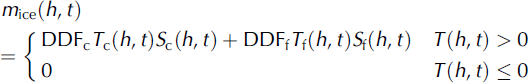
where DDF is the degree-day factor, T and S are daily mean air temperature and surface area of different elevation bands, respectively, and subscripts c and f are debris-covered ice surface and debris-free ice surface, respectively.
The degree-day factor is different for debris-free ice, debris-covered ice and snow, due to the different thermal responses, which are assumed constant in space and time in the corresponding elevation band. These factors were taken from Reference Zhang, Liu, Shangguan, Han, Xie and WangZhang and others (2005). The air temperature recorded at station A (Fig. 1) was used as input. Air temperature of different elevation bands was extrapolated by using a vertical lapse rate of 0.0068Cm–1 as derived from the average temperature data from stations A and B. In addition, we extracted the area of each 100 m elevation band from a 90 m resolution digital elevation model using Geographic Information System technology and obtained the debris-covered, debris-free and snow-covered surface area on the glacier.
Precipitation
On Keqicar Baqi glacier, the precipitation at the glacier terminus was 196.2 mm from July to September 2003. The maximum precipitation in a day was 29.3 mm, and <0.1 mm precipitation in a day was often observed (Reference Zhang, Liu, Han, Wang, Xie and ShangguanZhang and others, 2004).
For our computations, a linear increase in precipitation of 8.8% (100 m)−1 was assumed for Keqicar Baqi glacier (Reference Zhang, Liu, Han, Wang, Xie and ShangguanZhang and others, 2004). Additionally, 26.0% was added to measured precipitation to account for the gauge undercatch error (Reference Yang, Shi, Kang, Zhang and SevrukYang and others, 1989). A threshold temperature of 1.5˚C was used to discriminate liquid from solid precipitation (Reference Ye, Chen and ShiYe and others, 1996).
Model testing
Melt simulations were evaluated using the following equations:

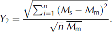
The criteria Y 1 and Y 2 are relative error and relative standard deviation, respectively (Reference HockHock, 1999), based on the differences between simulated melt, M s, and measured melt, M m, at each ablation stake on the glacier. The superscript bar indicates the mean, and n is the number of ablation stakes.
Results
Simulated and observed meltwater equivalents at the ablation stakes are compared in Figure 3. The simulations represent the spatial means of 100 m altitudinal bands, whereas the stake measurements refer to an individual point inside each of these areas. Considering the simplicity of the melt model, there is fair agreement between measured and simulated meltwater equivalents, although some points are not directly on the 1 : 1 line (Fig. 3).

Fig. 3. Measured vs simulated meltwater at the ablation stakes on Keqicar Baqi glacier, July–September 2003.
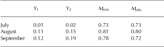
Table 1 lists the results of model evaluations using Equations (3) and (4). The results demonstrate that simulations of meltwater agree well with measurements in the 2003 melt season (Fig. 3a), although the degree-day factors obtained from the July data tend to underestimate the larger meltwater amounts in August and September (Fig. 3c and d). This error may be attributed to the different weather characteristics of different months. Reference Zhang, Liu, Han, Wang, Xie and ShangguanZhang and others (2004) suggest that July 2003 was predominantly rainy with overcast conditions, whereas dry, sunny weather predominated in August and September 2003. The degree-day factor will vary according to the relative contributions of the energy-balance components (Reference Ambach, Thomsen, Søgaard and BraithwaiteAmbach, 1988), and their relative importance varies with weather conditions. Therefore, our results should be interpreted with caution.
Table 1. Results of the meltwater simulations of Keqicar Baqi glacier for 2003 using a degree-day model. Y 1 and Y 2 are relative error and relative standard deviation, respectively, and are defined in Equations (3) and (4). M sim and M obs are average simulated and average observed meltwater equivalent (m)
Based on the estimates of meltwater and precipitation, it is calculated that glacier meltwater and precipitation are approximately 84% and 8%, respectively, of the source of the total discharge in the Ateoyinak river source region. Variation of air temperature, precipitation and the components of discharge in the Ateoyinak river source region is shown in Figure 4. These results suggest that the main source of discharge of the Ateoyinak river is glacier meltwater, and that precipitation is a secondary source under a warmer and wetter climate scenario.

Fig. 4. Variation of air temperature T (8C), precipitation P (mm) and runoff depth (mm) in the source region of the Ateoyinak river.
Conclusions
Our results suggest that with an increase in air temperature and precipitation in northwestern China, glacier meltwater becomes the predominant source for runoff to rivers in this area. We analyzed the impact of precipitation and glacier meltwater on the discharge (runoff) in the source region of the Ateoyinak river, southwestern Tien Shan, using a degree-day model. This type of model is widely used when there is a lack of data for the alternative energy-balance approach. Results show that modeling of the meltwater from Keqicar Baqi glacier during July–September 2003, based on the degree-day model, yielded fair agreement between simulated and measured meltwater. Based on the calculated meltwater and precipitation, it was concluded that glacier meltwater and precipitation were approximately 84% and 8%, respectively, of the total discharge in the source region of the Ateoyinak river.
Acknowledgements
We thank DeW. Cecil, E. Mosley-Thompson and H. Brecher for helpful comments and suggestions that greatly improved the paper. This work was supported by the Chinese National Fundamental Research Program (grant No. 90202013 and 40371026), the Knowledge Innovation Project of the Chinese Academy of Sciences (CAS; grant No. KZCX3-SW-345 and KZCX3-SW-339) and the Cold and Arid Regions Environmental and Engineering Research Institute, CAS (grant No. 2004102).


