


Location
A slide occurred in the upper basin of the Devastation Glacier (lat. 50° 36′ N., long. 123° 32′ W.) 1.2 km north-west of Pylon Peak (2 472 m) in Lillooet River watershed, Coast Mountain Range, British Columbia.
Description and causes of the slide
On 22 July 1975, a substantial mass of rocks, mud and ice, totalling an estimated (27–30) × 106 m3, broke away from the cirque of Devastation Glacier. It covered the entire length of Devastation Creek and blocked the confluence with Meager Creek. The slide originated under the ice of Devastation Glacier's accumulation area, at an elevation of 1980 m, travelled 6.5 km and descended 1150 m.
At present the active ice of Devastation Glacier is confined to the area above the cirque, about 3 800 m up-stream of where it was since the first record (Reference CarterCarter, 1932). The remnant of the tongue is a mass of stagnant ice covered by debris, still prominent in the narrow, sun-exposed valley, but has no visible connection with the active ice above.
From observations of the ice distribution over the catchment basin, it is concluded that the collapsed area in the slide was covered by glacier ice. As the slide went down, it gained momentum over at least one kilometre of dark-coloured stagnant ice in the valley and bounced off the valley walls at each sharp bend until it reached and dammed Meager Creek causing the formation of a small lake.
Geologically, the cirque area is underlain by Quaternary volcanic material, a part of Meager Creek volcanic complex (Reference ReadRead, 1977). At the base of the cirque, altered breccia, tuff, and ash deposits predominate. Poorly consolidated reddish-brown and grey volcanic rocks in the immediate area of the slide's origin form an unstable and apparently crumbly base beneath the ice cover (Fig. 1).
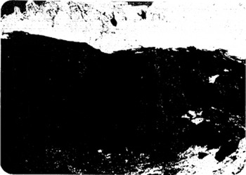
Fig. 1 Upper section of the slide area showing the crumbly base under the glacier ice. Dark vertical streaks are areas wet from melt water. Photograph 18 August 1975.
This poorly consolidated volcanic material incorporated in the main slide broke into comparatively large (2–3 m in diameter) blocks and boulders at the beginning of the descent. Further down, the slide material was broken into progressively smaller fragments. Within a few days, the debris at the terminus was converted into mud as it became saturated with water from Devastation Creek. Blocks of ice, over 10 m in size, mixed with the debris, were strewn over the entire path of the slide. The terminus of the deposited material was about 500 m wide and at the highest parts of the cross-section 30–40 m above the original ground level. This front stopped shortly after covering a sand bar near the confluence of Devastation and Meager Creeks. It was at this sand bar that the four men perished as they awaited the arrival of a helicopter.
Entering Meager Creek Valley, the slide dammed the waters of Meager Creek, a tributary of Lillooet River, forming a lake and flooding the surrounding forest.
As no volcanic activities or tremors were recorded on that day for British Columbia (personal communication from R. J. Wetmiller), the slide is attributed to the first or both of the following causes:
1. The weight of the glacier ice and the action of glacier melt water. Melt water was discharging into the unstable ground material beneath the ice at an increasing rate because of favourable melt conditions. As the material became saturated with water, its decreasing bearing strength failed under the weight of the ice above and resulted in the collapse (Figs 1 and 2).
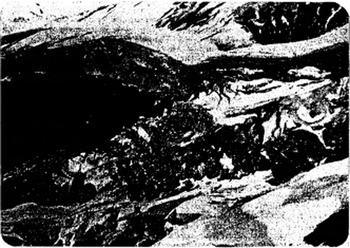
Fig. 2 Easterly part of the slide area. The ice thickness is about 48 m. Photograph 18 August 1975.
2. Some movement of ice in the form of a minor ice fall triggered the collapse of a large wet mass of supporting ground below the ice.
The volume of ice lost by the glacier is estimated at 2.5 × 10⁶ m3, approximately 2.5 × 10⁶ tonnes or 9% of the estimated (27–30) × 106 m3 total volume of rock-ice slide.


