


Introduction
As a part of the continuing U.S. Antarctic Research Program, a traverse party of 8 men left Scott Base (lat. 77° 51′ S., long. 166° 45′ E.) in three “Sno-cats” on 16 October 1959 to carry out a seismic–glaciological reconnaissance of Victoria Land, Antarctica. The traverse retraced the route of a traverse of the previous year across the Ross Ice Shelf, up the Skelton Glacier and out on the ice sheet to lat. 78° 02′ S., long. 154° 06′ E. Along the way movement points and accumulation stakes emplaced by the previous traverse were remeasured. The traverse then went north-west to the end point of a previous French traverse located at lat. 71° 08′ S., Iong. 139° 11′ E. From there an easterly course was taken until, on to February 1960, lat. 79° 37′ S., long. 161 ° 32′ E. was reached. There the vehicles were cached and the party was evacuated by air to NAF McMurdo. The traverse route is shown in Figure 1. Over much of the route the surface was very hard and rough, causing many breakdowns of the vehicles and finally damaging one so badly that it had to be abandoned.Reference Heine 1 At approximately 80 km. intervals full day work stations were made in order to take seismic soundings of ice depth and to dig 3 m. snow pits for observation of the stratigraphy. Nineteen such stops were made. Sastrugi size, form and orientation were observed and firn temperatures below 10 m. were recorded at each full day station. Between stations gravity and magnetometer data were also collected. These geophysical data are being analyzed at the University of Wisconsin and will be reported separately. Elevations were measured with aneroid altimeters by means of a modified “leap-frog” method.Reference Ostenso and Bentley 2 All of the glaciological data of the traverse have been published by the Institute of Polar Studies, The Ohio State University.Reference Stuart and Heine 3
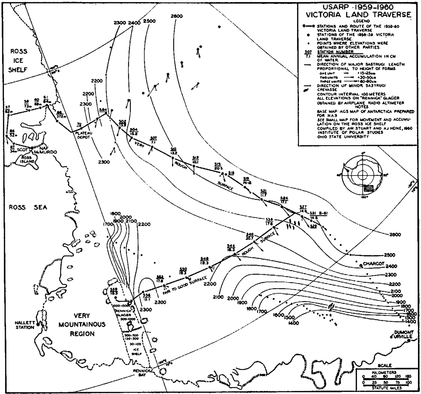
Fig. 1. Map showing the USARP 1959–60 Victoria Land traverse
Accumulation in Victoria Land
The nineteen snow pits indicate an average annual accumulation of 16 cm. of water equivalent, 14 cm, in the southerly half of the route and 18 cm. in the northerly half. The averages of the separate pits listed in Table I vary widely from each other, thus reducing the statistical reliability of these figures. This relatively high variability is caused by excessive development of layers of sublimation crystals and by uneven deposition. The latter conclusion is suggested by the nature of the snow surface in Victoria Land. Frequently, especially along the southerly half of the traverse route, the sastrugi were superimposed on a harder, glazed surface. This glazed surface was commonly intersected with cracks up to 2 cm. in width and over 50 cm. in depth, due apparently to either thermal contraction or differential settling. The suggestive fact about these cracks is that they ran under the sastrugi, but the latter were themselves never cracked. Thus, it seems that the hard surface, glazed through long exposure to wind action, is older than the sastrugi. Further, it can be said that accumulation since the formation of this surface has been in the form of sastrugi. This situation occurred on a considerable part of the trail of the traverse of the previous year. Their vehicle tracks were still visible for long stretches, being part of a typical glazed surface. In all cases where the tracks disappeared they were covered by sastrugi and reappeared on the other side of them. Since these tracks were at least ten months old it seems reasonable to expect that some of these bare areas could remain exposed for periods of a year or so. If such a hiatus, now buried, were encountered in a pit, then it would be impossible to say whether it represented one summer surface or more. Conversely, a buried sastruga would represent an above-average amount of accumulation for a given year. It is impossible to ascertain how often this situation occurred in these pits, but the fact that it may have happened at all makes it necessary to emphasize the approximate value of the interpretations reported in this paper. GiovinettoReference Giovinetto 4 observed bare, glazed patches known to be a year old near the South Pole Station. He also reports seeing bare patches of a glazed surface intersected by cracks. ListerReference Lister and Pratt 5 points out the possibility of an accumulation hiatus occurring at a given point for a period of as much as a year.
Table I. Accumulation, Elevation, Mean Annual Air Temperatures at Stations of the 1959–60 Victoria Land Traverse
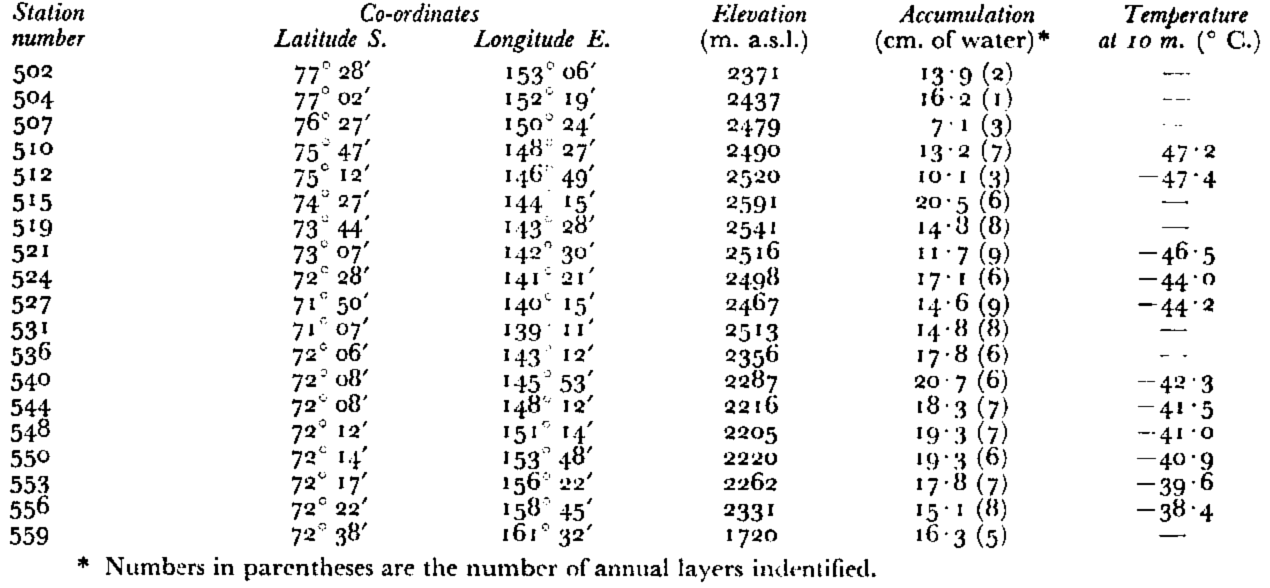
On the other hand, previous measurements of accumulation in Victoria Land tend to confirm the figures reported here. Charcot Station (lat. 69° 29′ S., long. 139° 02′ E.) received 14 cm. of water equivalent/yr. on stakes during the two years 1957–59Reference Cornet 6 In a pit dug at lat. 77° 22′ S., long. 139° 48′ E., VickersReference Vickers 7 reports an average annual accumulation of 15 cm. of water equivalent. LoriusReference Lorius 8 , Reference Lorius 9 took samples for deuterium isotope dating of the stratigraphy and, working independently of the authors, derived identical interpretations for the pits at Stations 507 and 516. The differences between the two interpretations for Station 531 were easily reconciled. His results from the rest of the pits have not yet been reported. It should be pointed out that deuterium isotope dating measures only the relative temperature of the snow at time of formation. Such a technique would also fail to recognize a hiatus in the statigraphy.
VickersReference Vickers 10 is at present analyzing the stratigraphy by means of grain-size data gathered by this and other traverses and his preliminary findings support the values reported in this paper.
Discovery of Glacier
At the end of the traverse route a large glacier was discovered through the joint efforts of the traverse party and Air Development Squadron Six of the U.S. Navy. The vehicles were cached on the glacier and the flight which evacuated the traverse party reconnoitered it before returning to NAF McMurdo. The head of the glacier is at about lat. 73° S., at an elevation of over 1,700 m. and drains northward into Rennick Bay (lat. 70° S., long. 161° E.). It has been provisionally named the “Rennick Glacier”. Its length is about 300 km. and it is over 30 km. broad in some places. In the central part the stream is divided by a group of nunataks. Northward of this point the surface drops rapidly to near sea-level and the glacier is thought to be afloat for the remainder of its length. Evidence of past breakouts was seen more than 30 km. southward of the present seaward limit of the glacier. The glacier is supplied from valley glaciers and ice streams on both flanks and by accumulation of the order of 16 cm. of water equivalent/yr. on its surface. The approximate size and position of the glacier is shown in Figure 1.
Sastrugi and Winds
Sastrugi directions are thought to indicate prevailing wind directionsReference Lister and Pratt 5 , Reference Mellor 11 and are so interpreted by the present authors. The parallelism of all the directions observed in Victoria Land supports this conclusion. Also it is possible to say that the prevailing winds are katabatic inasmuch as their directions vary as the direction of greatest surface slope varies. If these were upper winds, i.e. not katabatic, then it would be expected that their direction would not be so directly related to the surface slope. It is possible that these are indeed upper winds and the close relation between surface slope and wind direction is coincidental. However, there is a case where the direction of slope is counter to that of the major slope and the wind turns to by-pass it. This is the area east of Station 544 which extends to approximately Station 556. In this area the slope rises to the east in direct contrast to the major slope crossed previously. There the slope was down towards the north-east. For convenience the area between Stations 544 and 556 has been designated as the “counter slope area” and the slope covered by the earlier part of the traverse the “major slope area.” If the winds recorded at Stations 507 through 512, for example, were to continue their plotted courses, and even permitting a further swing to the west due to the Coriolis force, they should sweep the counter slope area. But in fact they do not. The winds in the counter slope area are either from due south or from the south-east. Not only are they from a different quadrant, but they display a decidedly greater scatter and the resultant sastrugi are smaller. Instead of sweeping the counter slope area the winds from the major slope area have followed the slope and have consequently acquired a more westerly component, draining into the large indentation in the surface east of Station d’Urvilic. This funneling of the wind off the major slope area down this identation is suggested as an explanation for the very high winds which prevail along the Adélie CoastReference Mawson 12 The winds in the counter slope area are probably in themselves katabatic but are generated over a shorter distance than are those in the major slope area.
Although the winds follow the slope they do not parallel the direction of maximum slope but have been pulled to the west, probably by the Coriolis force. This relation of the wind direction to the surface slope has been observed in the data of Hollin and Cameron,Reference Hollin and Cameron 13 and Dolgushin.Reference Dolgushin 14 In those areas and in Victoria Land the counter-clockwise pull of the Coriolis force has effected variation of as much as 45° west of the direction of maximum slope.Footnote * That is to say, the winds blowing down a surface which slopes down from south to north would blow from the south-east, not the south.
Movement of the Ross Ice Shelf
In January 1959 the Little America-Victoria Land traverse, led by Dr. A. P. Crary, installed a number of movement points on the Ross Ice Shelf between the Skelton Glacier and NAF McMurdo. These points were located by resecting on prominent topographic features on the west coast of the Ross Sea. Difficulty was encountered relocating some of these points in October 1959 when the movement stations were re-occupied, so usable data were obtained from only six of the points. The results are tabulated in Table II. The values obtained at two of the stations are far enough from land (at least 70 km.) to be considered indicative of the rate of flow of the main body of the ice shelf, but the other four are closer to land and exhibit slower rates of movement. The two points well clear of land are at opposite ends of a 1.5 km. line, so their values provide a check on each other and give an idea of the accuracy of the movement points generally. These points yield values of 863 and 824 m./yr., a discrepancy of less than 5 per cent. This error is considered to be very tolerable in view of′ the conditions under which the personnel had to work and the distances to the nearest geographic points on which angles were turned. The mean direction of movement for the two points is oo8° 30′ true.
Table II. Movement of The Ross Ice Shelf
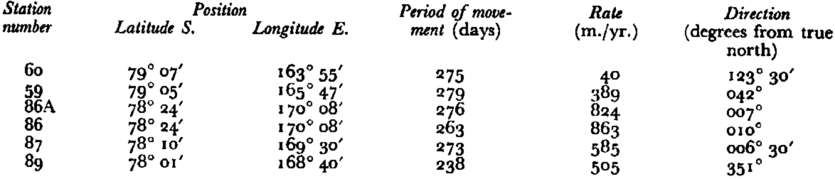
Stations 59 and 60 appear to be caught in a complex situation involving discharge of the Skelton Glacier (maximum value obtained by Wilson was about 110 m./yr.Reference Wilson 15 ) and the damming effect of Minna Bluff. Station 60 moved at the slow rate of 40 m./yr. in a southeasterly direction (123° 30′ true) while Station 59 is moving at 389 m./yr. in a north-easterly direction (042° true). Stations 87 and 89 are moving at 585 and 505 m./yr., respectively, in northerly directions with Station 89 indicating a more westerly component (006° 30′ and 351° true, respectively). This suggests that the influence of the Ross Archipelago and the drainage west of the line between White Island and Cape Crozier is being exerted already. The two points are roughly 40 km. from the nearest land. Wright and PriestleyReference Wright and Priestley 16 reported that Scott’s Depot “A”, about 14 km. east of Minna Bluff in 1909, moved an average of 450 m./yr. in a direction of 030° true between 1902 and 1909. This figure has long been quoted as a representative one for the entire Ross Ice Shelf, being until recently the only one available. This relatively slow velocity and the direction now suggest instead that it is the movement of the ice out of the Moore Embayment and around Minna Bluff into the main stream of the Ross Ice Shelf. These data are therefore from a marginal area and are not representative for the entire ice shelf. The movement data are plotted on the map in Figure 2.
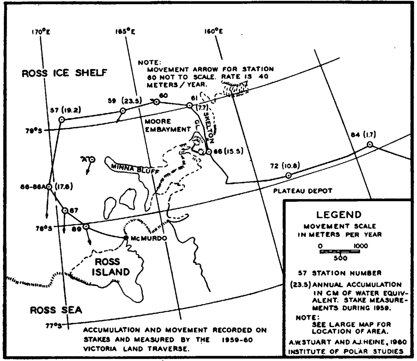
Fig. 2. Accumulation and movement recorded on stakes and measured by the 1959–60 Victoria Land traverse
Stake Measurement of Accumulation
At three of the stations on the Ross Ice Shelf 29 stakes were remeasured after a mean period of 268 days and indicate that snow accumulated at the rate of 20 cm. of water equivalent/yr. These and other stake measurements, covering slightly greater periods of time, are presented on the map in Figure 2.
Acknowledgements
This traverse was made possible by the support of the officers and men of Task Force 43 of the U.S. Navy. Special gratitude is felt for the co-operation given by the air component of the Task Force, Air Development Squadron Six. Mr. Louis Roberts of the U.S. Geological Survey was traverse navigator and supplied the co-ordinates of the traverse stations. Mr. Frans G. Vander Hoeven, traverse leader, supplied the elevations. Sastrugi data from the 1958–59 Victoria Land traverse were taken from the files of the Institute of Polar Studies. M. Claude Lorius, French observer, made the sastrugi observations and measured the deep temperatures on the 1959–60 traverse.


