


1. Introduction
Frost flowers, also referred to as salt flowers, are a very common sea-ice feature in the Arctic and the Antarctic during the cold seasons (Reference Perovich and Richter-MengePerovich and Richter-Menge, 1994). Frost flowers grow on newly formed sea ice from a layer of supersaturated vapour (Reference Martin, Yu and DruckerMartin and others, 1996). The thermo-molecular pressure gradient transports brine from the ice interior towards the surface where it is then drawn onto the crystals due to surface tension causing high salinities of up to 150 psu (Reference Drinkwater and CrockerDrinkwater and Crocker, 1988). Frost flowers are extremely effective collectors of blowing snow and quickly become snow-covered. Thus, layers of saline snow or slush are formed (Reference Ulander, Carlström and AskneUlander and others, 1995). The frost-flower layer is significantly modified within several days (Reference Perovich and Richter-MengePerovich and Richter-Menge, 1994).
There has been considerable interest in tropospheric bromine chemistry due to its role in ozone depletion (Reference McElroy, McLinden and McConnellMcElroy and others, 1999). Severe ozone depletion events which take place in the polar regions during springtime are associated with enhanced BrO occurrence (Reference Wagner and PlattWagner and Platt, 1998). Furthermore, BrO was recently proposed to be a key oxidant converting long-lived gaseous elemental mercury to total particulate-phase mercury and/or reactive gaseous mercury. This oxidative transformation process is believed to greatly enhance the deposition flux of this toxic heavy metal to the fragile polar biosphere (Reference EbinghausEbinghaus and others, 2002).
Satellite observations show that BrO-enriched air masses are always situated close to sea ice (Reference Richter, Wittrock and BurrowsRichter and others, 1997). The high amount of bromine in the boundary layer can be explained by auto-catalytic release from sea salt. A heterogeneous mechanism leads to an exponential increase of reactive gas-phase bromine, the so-called bromine explosion, since every Br atom entering the liquid phase has the potential to release two Br atoms to the gas phase (Reference Hönninger and PlattHonninger and Platt, 2002). Frost flowers provide a high relative surface area similar to fresh snow, i.e. 0.2–2m2 g–1 (Reference Perovich and Richter-MengePerovich and Richter-Menge, 1994). The surface area relative to the area covered gives a factor of about 50–1000. Recently, Reference Rankin, Wolff and MartinRankin and others (2002) found bromide concentrations in frost flowers that were around three times higher than in sea water. The combination of high bromide concentrations present in the liquid phase and the large surface area presented for exchange highlights the frost flowers as a potential source for tropospheric bromine.
Reference Rankin, Wolff and MartinRankin and others (2002) suggested that frost flowers are the source for the majority of sea salt transported inland as aerosol during winter. So far, sodium concentrations in ice cores have been used to deduce changes in the amount of sea-salt aerosol. The sea salt has been assumed to come from open water only. The larger sea-ice extent should cause a decreased entrainment of sea salt during glacial periods due to the larger distance from the open water. In fact the high levels of sea salt from glacial periods have been attributed to a more efficient zonal and meridional atmospheric transport (Reference PetitPetit and others, 1999). This interpretation of high sodium concentrations being due to increased cyclonic activity may be incorrect: it may rather be an indicator of increased sea-ice and frost-flower production.
Frost flowers change the electromagnetic properties of the newly formed sea-ice surface in the microwave as well as in the optical region of the electromagnetic spectrum. As the flowers protude a few centimetres above the surface into the boundary layer, the infrared temperature measured from the satellite is about 4–6 K colder than that of the same ice cleared of flowers (Reference Martin, Yu and DruckerMartin and others, 1996). At C-band (λ ≈ 5.6 cm) the brine-enriched slush layer under the frost flowers dominates the backscatter. The surface of the frost-flower crystals (surface roughness σ ≈ 0.5 cm) appears rough at Ku-band (λ ≈ 2.2 cm), yielding predominant surface scattering (Reference Drinkwater and CrockerDrinkwater and Crocker, 1988). Reference Ulander, Carlström and AskneUlander and others (1995) observed an increase of 5–10 dB for European Remote-sensing Satellite (ERS) backscatter, with the largest increase occurring for snow-infiltrated frost flowers. Using combined ERS synthetic aperture radar (SAR) and Landsat data, two different nilas backscatter classes were found at –17 and –10 dB, with the latter class believed to be affected by frost flowers (Reference Steffen and HeinrichsSteffen and Heinrichs, 1994). Reference Zabel, Jezek, Gogineni and KanagaratnamZabel and others (1996) suggested using the frost-flowers signal to classify ice roughly 5–20cm thick.
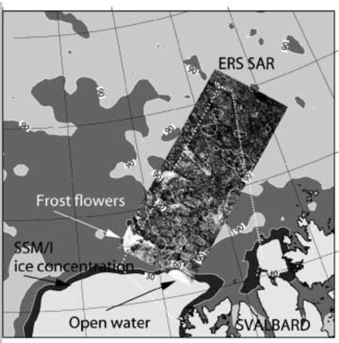
Fig. 1. ASI ice-concentration isolines, ERS SAR images and flight pattern of the Polar 4 on 12 March 1998.
It is difficult to analyze the SAR images recorded with ERS-2 since the ambiguities in the mean normalized radar cross-section σ o in general do not allow unique assignments to surface types. The ambiguity of the open-water and frost-flower backscatter signal can be resolved by using additional sea-ice concentration information derived from the 85 GHz Special Sensor Microwave/Imager (SSM/I) channels. The 19 and 37GHz channels of the SSM/I have been commonly used for sea-ice concentration retrievals (Reference Comiso, Cavalieri, Parkinson and GloersenComiso and others, 1997). The ARTIST Sea Ice (ASI) algorithm is a hybrid algorithm combining the model of Reference Svendsen, Mätzler and GrenfellSvendsen and others (1987) for the 85 GHz channels with a weather filter for the other SSM/I channels (Reference KaleschkeKaleschke and others, 2001). The 85 GHz channels provide higher spatial resolution and sampling rate (12.5 km vs 25 km) than the 19 and 37 GHz channels. There are about 64 measurements from the 85 GHz channels (15×13 km2 resolution), and only 4 independent measurements from the 19GHz channels (69×43km2 resolution), for each 100×100km2 SAR frame. In this paper, we present a feature-level data-fusion sea-ice classification method for ERS SAR and SSM/I. The method was evaluated using satellite underflights during the Arctic Radiation and Turbulence Interaction STudy (ARTIST), which was conducted in the environment of the Svalbard archipelago in March and April 1998 (Reference AugsteinAugstein, 2000).
2. Method
First, the incidence-angle dependence
of the radar backscatter is estimated. The backscatter (in dB) can be described approximately by the linear relation (Reference Ezraty and CavaineEzraty and Cavaine, 1999)
Within the overlap of the ascending and descending branch of the orbit, each SAR pixel is measured at two incidence angles. Thus, two co-registered complementary SAR images can be used to estimate the slope B and linear incidenceangle normalization (Reference Kaleschke and KernKaleschke and Kern, 2002).
Then, statistical, textural and spectral features are derived from ERS-2 SAR images using a sliding calculation window. Fast computational methods have been used for the calculation of the grey-level co-occurrence matrix (GLCM) which contains the conditional joint probabilities of all pairwise combinations of grey levels (Reference Clausi and ZhaoClausi and Zhao, 2002). The normalized extension difference (NED) derived from the spectral moments can be used to distinguish between the ice-free and sea-ice-covered ocean (Reference Schmidt and HeygsterSchmidt and Heygster, 1997). The above procedure requires the presence of swell in the image. However, ice concentrations derived from 85 GHz SSM/I data corresponding to the SAR pixels are independent of the sea state. The gridding and interpolation of the ASI sea-ice concentration C ASI data to the ERS SAR image grid was performed using continuous curvature splines in tension (Reference Smith and WesselSmith and Wessel, 1990). The features fi are scaled to the range [0,1] by using the hyperbolic tangent function
with mean μfi and standard deviation σfi computed only once for all of the data used in order to preserve the class-dependent biases. The resulting features ni reside in an N-dimensional unit-less space. For the results of this paper, we used only N = 2 dimensions, the mean backscatter σ o and the ice concentration C ASI. More features calculated from the SAR image or from other sensors can be added easily using the same formalism.
Kohonen’s Learning Vector Quantization (LVQ), a supervised neural network, was used for classification (Reference KohonenKohonen, 1997). LVQ approximates the Bayesian decision boundaries by a set of optimally placed reference vectors without a priori assumptions about the probability density functions.
The network is trained by learning from examples. Therefore representative examples of all occurring classes have to be selected. The classification result can be evaluated by using test data which were not used for the training.
3. Dataset
During ARTIST several satellite under-flights were carried out with the research aircraft Polar 2 and 4 of the Alfred Wegener Institute for Polar and Marine Research (AWI) while operating microwave radiometers, line scanners, radiation thermometer and a laser altimeter, as well as several sensors for measuring meteorological parameters.
The flight pattern of the Polar 4 aircraft on 12 March 1998 is shown in Figure 1 by the dashed white line. These data have been plotted over the ERS-2 SAR image and the ASI ice concentration as calculated from SSM/I data. The aircraft measurements and observations (600–1600m flight level) were co-located to the ERS-2 SAR image pixels using aircraft position data (global positioning system (GPS), tilt, heading) and assuming uniform ice motion. The minimum air temperature on 11 March 1998 was –40˚C according to the ARTIST buoy 9372 at 81.8˚ N, 10.9˚ E. Such cold temperatures promoted the growth of frost flowers. Backscatter values as high as those from the wind-roughened ocean sea surface (at 80.2˚ N, 11˚ E) caused by the frost flowers (at 80.7˚ N, 8˚ E) can also be seen in Figure 1.
4. Results
An average incidence-angle dependence of B = –0.3± 0.1 dB deg–1 was estimated for sea ice in a compacted marginal ice zone (Reference Kaleschke and KernKaleschke and Kern, 2002). The value B = –0.3 dB deg–1 was used for a linear incidence-angle normalization.
The SAR image was annotated along the flight track with the surveillance logs, making the visual interpretation of the SAR image much easier. About 50 homogeneous areas of five different surface types were manually selected in the SAR image. Open water (OW), first- (FY) and multi-year ice (MY), newly formed ice (NI) and newly formed ice with frost flowers (FR) were discriminated. The latter newly formed ice types are described as dark/light nilas and grey ice in the surveillance logs.
The mean backscatter value σ o was calculated using a sliding calculation window of 31 ×31 pixel size. The sea-ice concentration was calculated using the ASI algorithm (Reference KaleschkeKaleschke and others, 2001). The selected areas were used for training and testing of the neural network, respectively. The number of reference vectors for the LVQ algorithm was 500.
The overall classification accuracy of the training and the independent test data was 95.7% and 81.5%, respectively. The confusion matrix is given in Table 1. A total of 2717 randomly selected OW test data were classified correctly as OW (2662) and incorrectly as NI (51) and FY (34). The resulting classification error for OW is about 3%. The classification errors of NI and FY are about 20–30%. The worst result was achieved for FR which was confused with MY (about 50–100% error). However, there would have been larger errors without the use of ice concentration data. Without such data there would also have been confusion between FR and OW. This example shows that the combined analysis of SSM/I and SAR data can considerably improve the classification accuracy.
Table 1. Confusion matrix of 10 000 test data

The normalized radar cross-section σ o of the newly formed ice covered with frost flowers was about –7 to –2 dB. The frost-flower-covered area was about 15×15 km2, with a mean backscatter of –5 dB.
5. Conclusion
The backscatter value of newly formed ice can be as high as that of wind-roughened open water due to the influence of frost flowers. It is possible to separate the frost-flower and open-water signatures by the simultaneous analysis of SSM/I and SAR data. However, large errors remain due to the confusion of frost flowers with other ice types. To resolve these errors, other features must be considered for an advanced classification. Such features will be evaluated in an ongoing project.
Acknowledgements
The authors would like to thank the two reviewers for making useful suggestions. This research was funded by the German Research Foundation (DFG) under contract HE-1746/5-2 and HE-1746/11-1. The ARTIST project was funded by the Commission of the European Community under contract Nr. ENV4-CT97-0497-0487 (DG12-ESCY).


