


The Tibetan Plateau is the most glacier-concentrated area of the mid- and low latitudes. Climate fluctuations over the past century and climatic warming since the 1980s on the Tibetan Plateau have had a significant influence on these glaciers. Glacier retreat has significant social and environmental impacts in the Tibetan Plateau and surrounding regions. Water-supply variability, frequent glacial lake outburst flooding, glacial debris-flow hazards, unstable river and stream-flow, etc., all impact on the local population.
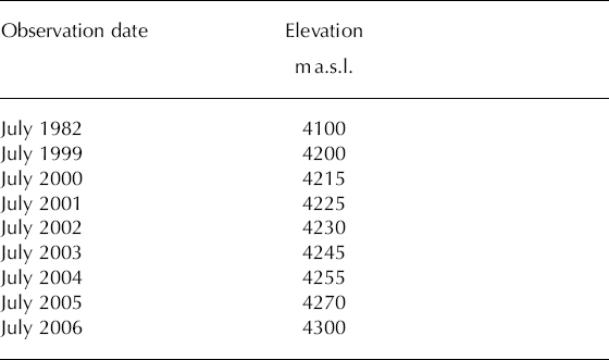
Yulong mountain, located in the Hengduan range (southeastern edge of the Tibetan Plateau), north of Lijiang, Yunnan province, China, is the southernmost glacierized area of mainland Eurasia (Fig. 1). Glaciers on Yulong mountain are typically temperate (maritime) compared with the polar/subpolar glaciers of most of the Tibetan Plateau. Glacier variations in this region have been investigated since 1999. The largest glacier on Yulong mountain, Baishui glacier No. 1 (BG1), which feeds the Baishui river basin, has an area of 1.52 km2 and is 2.7 km long (Reference PuPu, 1994). The elevation of the terminus of BG1 has been monitored since 1999. Results are listed in Table 1. According to Reference PuLi and Su (1996), the elevation of the BG1 terminus was 4100 m in 1982; it was 4300 m in 2006 based on our investigations. On average, it rose by 8.3 m a−1 between 1982 and 2006, and 14.3 m a−1 from 1999 to 2006, i.e. the terminus retreat rate has increased in recent years. The result is in agreement with Reference DyurgerovDyurgerov (2003), who indicated significant loss in glacier area and volume on the global scale, accelerating especially since the end of the 1980s.

Fig. 1. Maps showing the location of Yulong mountain (left) and glaciers distributed on Yulong mountain (right). Baishui glacier No. 1 and Yanggong glacier No. 5 are indicated.
Table 1. Observed variation of the elevation of Baishui Glacier No. 1 terminus, 1999–2006. The elevation of the glacier terminus in 1982 is also given
In recent years, large crevasses have developed in the firn basin of BG1. These formed in the accumulation zone and were not found during investigations in 1982. Figure 2 shows photographs of a new crevasse, formed between August 2005 and April 2006, in the firn basin at 4900 m a.s.l., and an embryonic crevasse developed in June 2006. The recently developed crevasses and ruptures may be linked to more rapid glacier movement over steep and variable bedrock (as a result of higher temperatures) since the 1990s. We suggest that during high-temperature summers, snowmelt enters the crevasses. Refreezing then leads to rupturing and instability of the firn basin and a speed-up of the flow. Thus, glacier stability is seriously impacted by crevasses developing in the firn basin.

Fig. 2. Left photo shows a new crevasse in the firn basin at 4900 m a.s.l., formed between August 2005 and April 2006 (right), and an embryonic crevasse developed in June 2006 (left). The arrow indicates that the crevasse in the left photo and that in the right photo are the same.
Yanggong glacier No. 5 (YG5) feeds the Yanggong river (Fig. 1). YG5 has an area of 0.72 km2, is 1.8 km long and has an equilibrium-line altitude of 4620 m a.s.l. (Reference PuPu, 1994). On 12 March 2004, a glacier-fall event at YG5 was accompanied by a small rockfall. Figure 3 shows the locality of the glacier collapse. On 21 April and 3 May 2006 we reached the collapse spot and investigated the event. The residual (i.e. it had suffered some melt) collapsed ice body was fanshaped (Fig. 3), with an outside (arc) length of about 870 m, based on global positioning system (GPS) measurement, and a height of 15 m. The altitude of the initial glacier disconnection location is about 4480 m, based on our investigation combined with the topography map. The elevation of the collapsed ice body is 3700 m. Therefore the ice body fell about 780 m. The area of the glacier below 4480 m a.s.l. is 0.44 km2, accounting for 61% of the total glacier area. Some glacier terminal fall events prior to the 1980s have been reported from the monsoonal temperate-glacier region of the southeastern Tibetan Plateau (Reference PuLi and others, 1986). These events were thought to be glacier surge phenomena. However, the 2004 YG5 glacier-fall event on Yulong mountain is thought not to be a surge since the collapsed ice body is large (more than half of the glacier).

Fig. 3. Photo showing the locality of the YG5 collapse event on 12 March 2004. Arrow 1 is the profile of the glacier collapse, arrow 2 the profile of the rock collapse, and arrow 3 the collapsed ice body.
Based on temperature data from 1951 to 2005 at Lijiang weather station, 25 km south of Yulong mountain, one factor that triggered the collapse event may be as follows. The mean temperature in March 2004 (13.6°C) was anomalously high, the highest in March since 1951 and 3.2°C higher than the multi-year mean March temperature (1951–2005). Furthermore, the mean temperature of the first 10 days of March 2004 (before the collapse date, 12 March) was 12.6°C, 3.3°C higher than the multi-year mean for the first 10 days of March. The anomalously high temperature would contribute to glacier melting. From Figure 3, we see that the slope of the underlying topography of YG5 is high, providing advantageous conditions for a collapse event. Therefore the unconventionally high temperature during March 2004 is a likely factor contributing to the collapse event.
Analyses of tree rings, ice cores, corals and historical records indicate that the 1990s were the warmest decade of the millennium (Reference HoughtonHoughton and others, 2001). According to our calculation (based on the Lijiang meteorological data), the climate warming around Yulong mountain is significant, especially since the end of the 1980s. The mean temperature during the past 20 years (1986–2005) is 0.4°C higher than the mean value during the 20 years 1951–70. Small temperate glaciers are sensitive to climate change, and the above observed glacier changes are attributable to the significant climate warming since the end of the 1980s in the region of Yulong mountain.
The increase in BG1 terminus elevation, the large crevasse formation in the firn basin and glacier-collapse event characterize the present accelerating glacier retreat in the monsoonal temperate-glacier area in the southeastern Tibetan Plateau. The YG5 collapse event on Yulong mountain in 2004 hints at the fragility of the small glaciers in the southeastern Tibetan Plateau under the present global warming scenario. The water resources, ecosystem and environment of the southeastern Tibetan Plateau will be impacted seriously as these glaciers are further diminished.
Acknowledgements
This research was supported by grants from the orientation project of the Chinese Acadamy of Sciences (kzcx2-yw-317) and funding the National Natural Science Foundation of China (40501014 and 90511007).
16 March 2007


