


Introduction
In an evocative article published in Antiquity in 1936, O.G.S. Crawford described the beauty and variety of the historic field boundaries in Cornwall in south-west Britain: “I had hoped”, he wrote “in the first moments of enthusiasm, to find some criterion by which to distinguish really ancient field walls from later ones, but on the whole I was not successful” (Crawford Reference Crawford1936: 163–64). The problem has proven remarkably intractable: as yet there are few examples of ancient field systems whose boundaries have been dated directly.
The problem arises, in part, from our dependence on unreliable proxies. Earthworks such as banks or terraces occasionally yield so much recognisable material culture that archaeologists feel confident about dating them (e.g. Koborov & Borisov Reference Koborov and Borisov2013). Such cases are rare, particularly in rural contexts, and excavations across earthworks are much more likely to yield either no artefacts, or a few indeterminate finds. Even when artefacts can be dated with certainty, it is rarely possible to know whether they are in primary or secondary contexts. Common strategies for establishing the age of earthworks include dating by association with adjacent archaeological features of known age, or analysis of stratigraphic relationships to features that can be dated independently (Johnston Reference Johnston2005; Roberts et al. Reference Roberts2017). Through careful analysis of relative chronologies, narratives of landscape development can be composed using termini post or ante quem (Herring et al. Reference Herring, Johnson, Jones, Nowakowski, Sharpe and Young2016). Where related features contain fills or other accumulations, such as the growth of peat, it is sometimes possible to date them using laboratory methods (Whitefield Reference Whitefield2017). The challenges of understanding taphonomic processes, however, mean that these proxies can be unreliable. Ditches, for example, were often regularly cleared out, and ditch fills do not necessarily accumulate at predictable or constant rates (Williamson Reference Williamson2016).
Samples from earthworks can be directly dated using radiocarbon or optically stimulated luminescence (OSL) methods (e.g. Beckers et al. Reference Beckers, Schütt, Tsumkamoto and Frechen2013; Porat et al. Reference Porat, Davidovich, Avni, Avni and Gadot2018; Quirós-Castillo & Nicosia Reference Quirós-Castillo and Nicosia2019), although ecofacts, soils and sediments are liable to similar problems to those affecting artefact-based dating. Material within earthworks can be disturbed through post-depositional processes, which may be virtually impossible to recognise using standard archaeological methods—particularly when studies rely on just one (or a few) quantitative age estimates, or dates from an exposed profile. While using bulk samples may mitigate the impact of animal or other disturbance, this tends to yield age overestimates due to the presence in the environment of much older carbon fractions (Puy et al. Reference Puy, Balbo and Bebenzer2016; Ferro-Vázquez et al. Reference Ferro-Vázquez, Kaal, Arévalo and Boado2019).
In this article, we present a method that can provide a reliable chronological profile directly from the sediment used to build earthworks. We use Bosigran in Cornwall as a case study, demonstrating the construction and development of field banks with later prehistoric origins. The method is important, as it is relevant not only to Cornwall's field banks, but also to many types of earthworks around the world. Accurate dating of features such as terraces, boundary banks or cultivation ridges could transform our understanding of the origins and evolution of landscapes, and help us appreciate how these anthropogenic features have contributed to shaping cultural and ecological patterns.
Analytical survey of field systems at Bosigran
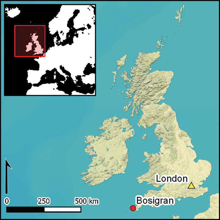
In 1978, the National Trust acquired Bosigran, the westernmost of several ribbon-shaped medieval hamlet-lands in the modern parish of Zennor, west Cornwall. These ribbons provided each hamlet—comprising around half a dozen households—with access to all types of land: upland rough grazing and turbary (areas of peat dug and dried for domestic fuel), valley-side meadows, arable on the coastal plateau and cliff grazing above the sea shore. Acquisition by the Trust was part of a campaign to protect key parts of an agricultural landscape that had long been regarded as especially beautiful and unusually ancient, with granite-and-earth boundaries forming small fields, dubbed the ‘work of giants’ (Crawford Reference Crawford1936; Balchin Reference Balchin1954; Herring et al. Reference Herring, Johnson, Jones, Nowakowski, Sharpe and Young2016: 58–64). These were vulnerable, as government grants encouraged farmers to amalgamate fields into larger units by grubbing up boundaries. Bosigran is situated on the gently sloping coastal plateau to the north of two tor-topped hills, Carn Galva and Hannibal's Carn. The fields are currently used as permanent pasture, except where a broad strip of particularly stony, rough land called Halldrine Croft crosses the western part (Figures 1–2).

Figure 1. Bosigran, Zennor from the north-west, showing current forms of the three principal prehistoric field patterns on the coastal plateau: irregular, regular and coaxial (Cornwall and Scilly Historic Environment Record, F88/036, 2008; © Cornwall Council).

Figure 2. Map of case-study area with six types of field systems identified by the West Penwith Survey (derived from Herring et al. Reference Herring, Johnson, Jones, Nowakowski, Sharpe and Young2016: figs 4.11, 4.12, 4.21, 4.30), and five field boundary sites studied using OSL-PD (figure by S. Vervust).
To understand their significance better, the West Penwith Survey, supported by Historic England and the National Trust, recorded the peninsula's field patterns in detail between 1981 and 1983, and developed methods to establish relative chronologies through analysis of the physical, functional and systemic relationships between boundaries and other features. These local relative chronologies enabled the different types of field patterns to be arranged sequentially. Periods of origin for the field types were suggested based on their association with independently dated features, such as houses (Herring et al. Reference Herring, Johnson, Jones, Nowakowski, Sharpe and Young2016). Bosigran was also surveyed at 1:1250 scale between 1981 and 1983 by a team from the National Trust and the Cornwall Committee for Rescue Archaeology using plane tables and alidades. For each feature, the morphology and any functional or chronological relationships with other features were recorded. Subsequent analysis enabled preparation of a landscape development narrative for an archaeological management plan (Herring Reference Herring1987a).
The six distinct types of fields at Bosigran, covering 125 acres (50ha), are introduced here in the sequence established by the survey analysis (Figure 2).
Type 1
There is a fragment of a coaxial field system in Halldrine Croft, with slightly sinuous, parallel, principal long boundaries and cross boundaries creating roughly rectangular fields delineated by stony banks with slight lynchets. These boundaries are overlain to their east by smaller fields with substantial lynchets. A second-millennium BC origin was proposed for the coaxial fields, based on Dartmoor comparators and through association with four roundhouses (Johnston Reference Johnston2005; Fleming Reference Fleming2007; Fyfe et al. Reference Fyfe, Brück, Johnston, Lewis, Roland and Wickstead2008; Herring et al. Reference Herring, Johnson, Jones, Nowakowski, Sharpe and Young2016: fig. 4.10). Other fragments of coaxial fields recorded on Zennor Head and Treveal Cliff, and above the plateau in eastern Zennor, suggest that much of West Penwith's coastal plateau was also covered by Bronze Age coaxial fields (Herring Reference Herring1986a & Reference Herringb, Reference Herring1987b; Herring et al. Reference Herring, Johnson, Jones, Nowakowski, Sharpe and Young2016: 155–57, fig. 6.15).
As with those found on Dartmoor and Bodmin Moor, the coaxial fields were probably worked by communities containing several hamlets of farming households. High population levels, considerable agricultural productivity and a complex society can be modelled (Fleming Reference Fleming2007; Herring Reference Herring and Chadwick2008). The cliffs and downs surrounding these fields were presumably used for rough grazing.
Type 2
The Bosigran farming landscape may have been reorganised early in the first millennium BC (Herring Reference Herring and Chadwick2008)—a phenomenon seen elsewhere in Cornwall. Upland commons were extended while the coastal plateau was covered by dense, regular patterns of smaller fields. The main regular field system at Bosigran has long, curving boundaries, whose concentric pattern follows the contour; field survey indicates that the northernmost two lines were attached successively. Cross-boundaries subdivided the land into segmental fields.
Substantial lynchets, both positive and negative, appear to have developed along the fields’ boundaries; some, on the steep northern clifftops, survive to 3.20m in height. Most are within the still functioning field system and, where not reduced and ploughed over, they continue to serve as field boundaries; they are usually revetted on their downhill sides, and have livestock-proof walls or fences along their tops. The removal of such massive works was difficult before the era of mechanised farming.
Regular field systems in West Penwith were associated with hamlets comprising later prehistoric stone-built roundhouses (typically five or six households), some of which were transformed into groups of Romano-British courtyard houses (Herring et al. Reference Herring, Johnson, Jones, Nowakowski, Sharpe and Young2016: 168–78). At Bosigran, closely spaced roundhouses were linked by banks to create five courtyard houses (Herring et al. Reference Herring, Johnson, Jones, Nowakowski, Sharpe and Young2016: fig 4.15). Land in the fields in West Penwith was probably shared among the several households there and intermixed, the lands held and worked by each household being scattered across the field system rather than being all in one consolidated block—a scenario that would explain why settlement was nucleated into hamlets placed roughly central to the field systems. The fields’ regular shape would have helped people to assess and demonstrate equitable division of land, using lengths or widths as guides (Herring Reference Herring and Chadwick2008: fig. 17).
Type 3
In eastern Bosigran, a field system broadly contemporaneous with type 2 was irregular and accretive; fields were added one at a time, their kinking boundaries influenced by the incorporation of large boulders. These irregular fields appear to have been laid out by inhabitants of single farmsteads, who did not need to incorporate shareholding into their designs (Herring Reference Herring and Chadwick2008). The lack of straight sides also suggests that the mode of cultivation (spade or plough) had little influence on field shape, and hints that the regularity seen in most of West Penwith's later prehistoric fields was indeed due to the needs of land division and shareholding (Herring et al. Reference Herring, Johnson, Jones, Nowakowski, Sharpe and Young2016: 88).
Type 4
Attached to the regular field system are small irregular fields, similar to those of type 3 in eastern Bosigran. Seemingly associated with the prehistoric hamlet, their form suggests piecemeal enclosure, presumably undertaken by individuals with the agreement of the hamlet's other farmers. Field shapes and sizes responded to local topography, with tiny clifftop fields created between carns (local term for tors) and earthfast boulders.
The later prehistoric field systems were surrounded by open ground on cliffs, uplands and valley sides, where farmers probably turned out their livestock in the summer (freeing fields for crops and hay), obtained fuel (e.g. turf, gorse) and animal bedding (e.g. bracken), and collected, trapped, hunted and fished for wild food.
Type 5
The medieval hamlet of Bosigran was not established on top of an earlier prehistoric or Romano-British one. Instead, it was placed where the lands of the two courtyard-house settlements met. Nevertheless, the inherited field systems at Bosigran appear to have been reused, largely unaltered, in terms of their physical boundaries. Some newly created (type 5) medieval strip fields survive as low banks subdividing a southward extension of the main prehistoric field system. Individual shareholdings, including these strips, would have been intermixed throughout the field system.
Type 6
Although post-medieval farmers at Bosigran largely reused inherited prehistoric, Romano-British and medieval fields, many kilometres of boundaries were rebuilt, refurbished, refaced and heightened. Boundary widenings consumed small ‘leazing’ stones taken from cultivated land. Some boundary types are exclusively post-medieval, including stone-faced stone walls, dry-stone walls and single-stone walls. Cornish hedges and revetted lynchets also continued to be constructed (Herring et al. Reference Herring, Johnson, Jones, Nowakowski, Sharpe and Young2016: 58–64). Changes in the nineteenth century included the removal of 246m of field boundary between 1841 (Kresen Kernow, TM/255, Zennor Parish Tithe Map) and 1908 (Ordnance Survey 1:2500, LXVII.4, second edition), and the building of 610m of new boundaries, mainly as dry-stone and stone-faced stone walls, creating crofts, or privately held enclosures of rough ground, on the northern fringe of the Bosigran field system. In the later twentieth century, 33 field boundaries totalling 2290m were mechanically removed to enlarge fields for modern farming (Herring et al. Reference Herring, Johnson, Jones, Nowakowski, Sharpe and Young2016: 100).
Dating methods: OSL-PD in the field and the laboratory
OSL profiling and dating (OSL-PD) were used to obtain sediment chronologies for five key field boundaries at Bosigran, representing different types of enclosure. By establishing detailed chronologies, it was possible to investigate the sequence(s) of construction, modification and use of these features. The results can be extrapolated from the individual features to the wider network of fields, with reference to the relative chronologies established through field survey, thereby significantly improving our knowledge of landscape development in West Penwith from the Bronze Age onwards.
Fieldwork was undertaken in June 2018, comprising the hand-cutting of small trenches into each of the earthworks investigated, exploiting previously eroded areas in the earthworks to minimise the damage. This article focuses on results from sites 1 and 3, at which our trenches cut through the boundary banks to investigate the creation and development of the earthworks. At sites 2, 4 and 5, separate trenches were dug on the north and south sides of each earthwork, but as these yielded no data relating to the complete history of each feature, they are not discussed in detail here. All trenches were cut to the depth of the natural substrate beneath the banks, a weathered granite bedrock locally known as ‘rab’. As the trenches were opened, they were immediately covered under opaque black tarpaulins, to prevent exposing the samples to sunlight and zeroing their luminescence signal. Further cleaning of the exposed sections was undertaken under this dark cover. Small quantities of sediment (5–10g) were collected at regular intervals (normally <100mm) throughout the sediment stratigraphies for immediate analysis using portable OSL equipment (see Figure 3 and the online supplementary material (OSM)). This information was used to construct luminescence-depth profiles for the sections investigated. These were interpreted in the context of the archaeology and sedimentology, and used to identify key horizons for dating. Additional quantities of sediment were recovered from each of the profile positions for preliminary laboratory characterisation. These were collected in small copper tubes, measuring 25 × 30mm in length, to ensure that the samples remained light-safe. Sediment samples for dating purposes were collected by driving 40mm diameter stainless steel tubes, measuring 0.12m in length, into the exposed section face. The trenches and their associated stratigraphies were recorded as small archaeological excavations using single-context recording sheets, photographs and section drawings, and their exact locations were mapped using a total station and differential GPS.

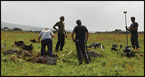
Figure 3. Site 1 being protected from light under a dark cover (A), and analysis of soil samples using the portable OSL reader (B) (photographs by S. Vervust).
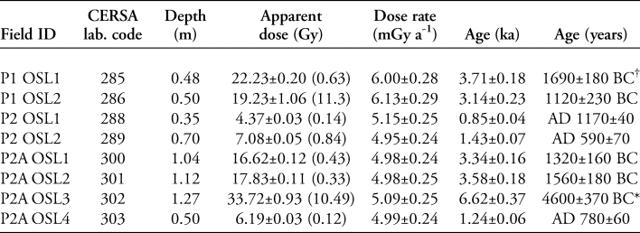
Laboratory analyses were undertaken at the luminescence laboratories in the School of Earth and Environmental Sciences at the University of St Andrews, following established protocols (full details in the OSM). Our initial laboratory investigations examined the luminescence behaviour of the Bosigran quartz, and explored apparent dose (absorbed dose, Gy) and sensitivity (luminescence per unit dose, counts per Gy) distributions throughout the investigated sediment stratigraphies. This analysis provided the first indication that the agricultural and archaeological soils in the fields immediately adjacent to the banks were relatively shallow. From approximately 0.50–0.60m depth in the sedimentary stratigraphies, the profiles encompass sediments relating to early soil formation before agricultural exploitation of the area. All dating samples selected on the basis of the field profiles and their potential archaeological significance were subjected to a quartz OSL single aliquot regenerative dose protocol, coupled with dose-rate determinations by high-resolution gamma spectrometry (see the OSM). Table 1 lists the apparent doses, the estimate of the environmental dose rate at each dating position and the corresponding depositional age for all samples. The significance of these sediment ages are discussed below.
Table 1. OSL depositional ages. A luminescence age is the quotient of the apparent dose (Gy) over the environmental dose rate (mGy a-1). Analytical methods are described in the online supplementary material (OSM).

† Low-dose tail to approximately 20 Gy, corresponding to sediment age of c. 1300–1400 BC.
* Large De distributions; age calculated from low-dose population.
Our interpretation of the constructional sequences of the earthworks was informed by the juxtaposition of the proxy luminescence data obtained in the field, with the apparent dose and sensitivity distributions generated in the laboratory. This is illustrated in Figures 4–6, which show OSL signal intensities, sensitivities and apparent doses plotted and overlain on the section drawing (the interpolation in Figures 4c & 6 is based on the apparent dose values of the profiling and dating samples). This led to a re-appraisal of our luminescence stratigraphy-based field interpretations. We originally assumed that the lower signal intensities observed at the base of the profiles were an indication that the lower strata were better bleached (i.e. exposed to sufficient light before burial to reset a previously acquired luminescence signal), and that the higher signal intensities for the sediments above indicate that these were re-deposited after construction (Figures 4a & 5a). The lower signal intensities returned for the rab, however, instead reflect the lower sensitivities of these sediments (Figures 4b & 5b). The depositional histories of these sediments are therefore less complicated than we originally assumed, and are characterised by normal age-depth progressions (Figures 4c & 6). At site 3, our strategy of sampling at a high resolution for OSL-PD allowed us to appraise in detail—both spatially and temporally—the construction and ‘growth’ of the lynchet and bank. This is discussed in more detail below.

Figure 4. Section drawing of site 1 showing OSL signal intensities (a), sensitivities (b) and an interpolation of apparent dose (c) (figure by S. Vervust). All values are tabulated in the online supplementary material (OSM).

Figure 5. Section drawing of site 3 showing OSL signal intensities (a) and sensitivities (b) (figure by S. Vervust). All values are tabulated in the online supplementary material (OSM).

Figure 6. Section drawing of site 3 showing an interpolation of apparent dose (figure by S. Vervust). All values are tabulated in the online supplementary material (OSM).
The case studies: prehistoric and later boundaries at Bosigran
The first site to be investigated was located in Halldrine Croft, the rough ground in the western part of Bosigran (site 1). The targeted field boundary forms the northern main axis of the surviving coaxial field system. According to the West Penwith Survey, these fields probably originated in the second millennium BC (Middle Bronze Age). They do not appear to have been reused as boundaries in later field systems, and they are not particularly prominent in the modern landscape. The feature we examined survives as a low stony bank, around 0.40m in height, oriented approximately west–east (Figure 7). A small 0.80m-wide cutting was excavated across it, reaching the natural rab at approximately 0.70m below the ground level (context 4 on Figure 4). A context comprising granite cobbles and boulders at between 0.20 and 0.50m below the surface, in the centre of the trench, was interpreted as the rubble-built stone core of the bank (context 2 on Figure 4).

Figure 7. Fieldwork on the low stony bank at site 1 (looking south) (photograph by S. Vervust).
Profiling and dating samples were collected from both the east and west sections of the trench. Their luminescence profiles revealed a condensed sequence of agricultural soils in use over the last 2000 years, spanning only the top 0.30m of the stratigraphy. Soils below that appear not to have been reworked since the Bronze Age. Dating samples taken from the bottom of the bank's stone core provided a terminus post quem for its construction of 1690±180 BC (CERSA 285) and a terminus ante quem of 1120±230 BC (CERSA 286), thus confirming the Middle Bronze Age date suggested by the West Penwith Survey (Figure 4c). The final 0.10m of the profile overlying the rab is characterised by very early (pre-Neolithic) soil formation.
Next, fieldwork moved to a series of substantial stone-faced lynchets belonging to the regular western (sites 2, 3 and 4) or irregular eastern (site 5) field systems of Bosigran, all of which were considered to be of late prehistoric origin based on the results of the analytical field survey. Site 3 was investigated in the most detail. A narrow trench was excavated through the boundary to expose and sample the entire stratigraphic sequence. This lynchet is one of several curving primary lines that delimit boundaries in the regular field system (Figure 8). These fields were dated relatively by their association with a small hamlet of stone-built Iron Age roundhouses, later transformed into Romano-British courtyard houses, which are located along the lynchet to the west of the sampling site. The earthwork seems to have acted as a field boundary since its construction, as it forms a prominent feature in the present landscape, with a drop of approximately 1.75m between the dry-stone wall on top and the ground surface downhill to the north.

Figure 8. The stone-faced lynchet at site 3 (looking west) (photograph by S. Vervust).
The excavated section revealed a feature with large granite boulders at its centre, which we interpret as the remains of a stony bank (contexts 24 and 26 on Figures 5–6). To provide detailed insights into the lynchet's construction and diachronic development, a total of 40 profiling samples and six dating samples were collected from across the earthwork. The West Penwith Survey suggested that the Bosigran lynchets would already have been quite substantial by c. AD 500, as it was assumed that they had been accumulating eroded soil on their southern (uphill) sides for almost 1500 years (Herring et al. Reference Herring, Johnson, Jones, Nowakowski, Sharpe and Young2016: 88). The OSL-PD, however, suggests that the stony bank at the core of the lynchet was constructed in the Middle Iron Age by cutting down into older Bronze Age soils (after c. 1320±160 BC (CERSA 300)) and underlying rab (Figure 6). This boundary appears to have remained fairly low until early medieval times, when the top and sides of the stony bank were progressively augmented by repeated additions of soil and smaller stones. This suggests that the landscape was exploited in much the same way from the Middle Iron Age until the Early Middle Ages (c. AD 590±70 (CERSA 289)), when management practices appear to have changed. This is notable because it probably coincides with the abandonment of the adjacent courtyard house settlement and the foundation of the new hamlet of Bosigran. The profiling data show that the process of earthwork enlargement continued throughout this period, and on into the Late Middle Ages and post-medieval periods, resulting in the substantial earthen bank that now stands on the lynchet. During the later Middle Ages, a new stone facing was added to the lynchet's northern side, and in the post-medieval period, a dry-stone wall of granite boulders was built along the top of the bank. On the southern side, the gradual accumulation of soil against the developing bank from the Early Middle Ages to the present day accounts for no more than 0.40m of the sediment stratigraphy. Figure 6 illustrates this developmental sequence.
The creation and evolution of the stone-faced lynchets at the other three sites (2, 4 and 5) were found to adhere to a very similar pattern to that revealed at site 3. As sections were not cut through these features, no direct dates for their construction are available. They too, however, seem to have been constructed by taking advantage of the sloping topography and by cutting into Bronze Age and earlier soils that probably pre-dated construction of these boundaries by at least a thousand years.
Conclusions
This article reports two main conclusions. First, we have demonstrated the use of OSL-PD to date the origins of archaeological earthworks directly, and to understand subsequent stages in their development and growth. Dating earthworks is a long-standing problem in archaeology, as the traditional proxies can be unreliable for various taphonomic and stratigraphic reasons. OSL-PD helps to address these issues by generating chronologies directly from sediments and soils, and because the use of profiling enables us to identify inverted, redeposited or intrusive material. The method is cost-effective: profiling can reduce significantly the number of dating samples that are required to generate reliable results. Although the minerals in some soils are unresponsive to luminescence methods (Bateman Reference Bateman2019), the OSL-PD technique provides a new way to date and analyse the development of many types of earthworks around the world.
Secondly, the study provides the first direct dates for prehistoric and medieval field boundaries in Cornwall. The long tradition of analytical field survey in West Penwith, on Bodmin Moor (Johnson & Rose Reference Johnson and Rose1994) and elsewhere has produced detailed records of extensive landscapes, relying on relative chronologies to assign field boundaries to broad historical periods. Although the early field systems of south-west Britain are widely recognised for their great historic significance—as well as their beauty and ecological value—their absolute dating is currently based on a few isolated and contested radiocarbon dates (Caseldine Reference Caseldine1999; Amesbury et al. Reference Amesbury, Charman, Fyfe, Langdon and West2008). Our work at Bosigran confirms the arguments of the archaeological surveyors, who suggested that the origins of its field systems lie in the Bronze and Iron Ages. Results from OSL-PD, however, allow us to present a nuanced picture of their development, which shows that their character changed in important ways during the Early Middle Ages and later. Future applications of the method, combined with a full range of soil-science techniques, should allow us to create detailed and securely dated accounts of land-use history. In doing so, we will make significant progress in dating the ‘work of giants’, which so vexed Crawford in the 1930s and many others since.
Acknowledgements
This work has received funding from the FWO (Research Foundation—Flanders) and the European Union's Horizon 2020 research and innovation programme under the Marie Skłodowska-Curie grant agreement (665501). The authors are very grateful to the National Trust for their support, in particular to Ian Marsh, James Parry, Ash Pearson, Shaun Boyns and the volunteers who helped with the fieldwork. We would also like to thank Bosigran farmers Bob and Liz Scambler for allowing us to investigate their field boundaries and for their keen interest in our research. We were assisted in the field by Francesco Carrer, Niels Dabaut and Maria Duggan, and we thank them all for their invaluable help.
Supplementary material
To view supplementary material for this article, please visit https://doi.org/10.15184/aqy.2019.138


 Open access