


Introduction
Carthage, in antiquity one of the most important Mediterranean metropoleis, is today a suburb of Tunis (Figure 1). The city has been extensively studied, mainly in the 1970s–90s when a number of international teams worked in part simultaneously in the city at a time in which ongoing urban development seriously threatened the integrity of the site. Although Carthage has been on the UNESCO list of World Heritage Sites since 1979, the political and social situation specific to the site has left much to be desired concerning its protection, preservation and presentation (Altekamp and Khechen Reference Altekamp and Khechen2013). In 2015, the German Archaeological Institute (DAI) in Rome and the Tunisian Institut National du Patrimoine (INP) started a new joint archaeological project, continuing a tradition of cooperation that had started in 1974 and resulted in the creation of two archaeological parks, the Quartier Magon and the Quartier Didon, and respective publications (monographs: Rakob Reference Rakob1991; Reference Rakob1997; Reference Rakob1999; Dolenz and Flügel Reference Dolenz and Flügel2012). For the new project, one of the most promising and still most endangered regions of Carthage was chosen: the circus region in the southwestern city quarter.
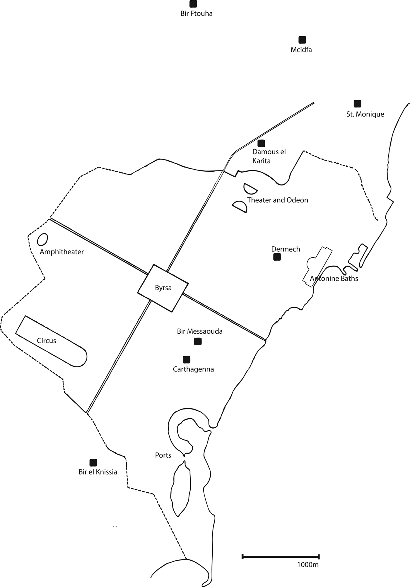
Figure 1. Schematic plan of Carthage with main Roman buildings, decumanus maximus, cardo maximus, Late Antique city wall and position of main ecclesiastical buildings indicated (R. Bockmann, based on Ennabli Reference Ennabli1997, 6, fig. 1).
The circus, the biggest building of the Roman city, is only very fragmentarily known – in general, this part of the city has not been extensively studied. At the same time, being on the border of a number of – in the strict sense – originally illegal but today well-established settlements, its territory is still today in danger of being overbuilt by their expansion. One of the aims of the project is to support the Department of Antiquities in its effort to stop the encroachment onto the territory of what is (in theory, at least) a non aedificandi zone of the UNESCO World Heritage Site. Our project intends not least to visibly show the existence of one of the most important buildings of the Roman city and to hopefully protect it better by making its position and importance known to local inhabitants and decision makers. The project is co-directed by Ralf Bockmann for the German Archaeological Institute's Rome department and Hamden Ben Romdhane for the Institut National du Patrimoine in Tunis. According to the magnitude of the monument and region studied, an international team of specialists was put together, in which Bockmann concentrates on the Roman, Late Antique and Byzantine periods, Ben Romdhane on the Roman period and epigraphy (whilst coordinating all relations with the Tunisian authorities), Frerich Schön of Tübingen University on the Roman period (with an additional function as coordinator of scientific probing and analysis) and Iván Fumadó Ortega of Valencia University on the Punic period, while at the same time being responsible for surveying. Trenches were directed by Stefano Cespa (Tübingen University), Boutheina Maraoui Telmini (Tunis University) and Yamen Sghaier (INP). Nicole Röring from Bamberg is the specialist for architecture on the project. The finds department is organised by Elyssa Jerray (Paris), who also heads the study of the Roman pottery, whereas the study of the Punic pottery is headed by Hanni Töpfer (Tübingen University). A geophysical survey was carried out by a team from Cologne University led by Manuela Broisch. Colleagues from the INP and students of Tunis University have helped in the excavations as interns and have contributed considerably to the project.
There are two main areas of study for our investigation. The first concerns the circus itself: we want to understand when it was built, how it was built, what it looked like and how it worked, how it changed over time in design and function and when it ceased to exist, and what happened afterwards with the building and site. The second study area concerns the topographical development of this part of the urban site in a broader sense: what did the Punic and early Roman settlements look like, and how did the building of the circus change the urban fabric, how was it integrated into and how did it influence its surroundings?
The collaborative project started in 2015 and so far has seen three seasons of fieldwork of three weeks in each year up to 2017. In preparation, a geophysical survey had already been carried out in 2013. Currently, the results from these interventions are being prepared for detailed publications. A second three-year project phase is planned to start in 2019. The aim of this paper is to present the project to a wider audience and give a first short summary of the work achieved so far, and of the most important results. For detailed discussions, interpretations and wider contexts, readers are asked to consult more detailed papers we intend to publish subsequently.
History of research at the circus and southwestern quarter
Roman Carthage, founded as Colonia Iulia Concordia Karthago in 29 BC on the remains of the Punic city that had been destroyed more than 100 years previously at the end of the last Roman–Punic war, was the capital and by far the largest city of the African provinces and was adorned with the full set of public buildings, many of them only superseded in size and decoration by their counterparts in Rome itself. The circus was no exception. Its remains had been identified as such on the ground in the 1830s and described several times thereafter in different travellers’ notes (Falbe Reference Falbe1833, 40, pl. 1, no. 64; Dureau de la Malle Reference Dureau de la Malle1835; Barth Reference Barth1849; Sainte-Marie Reference Sainte-Marie1884). It is situated in the southwestern quadrant of the city, on the southern edge of the city in a quarter where the amphitheatre was also located (see Figure 1). Ch. Saumagne, who reconstructed the Roman street grid of Carthage from the groma on Byrsa hill, excavated in the area, where he found a porticus with exedra and a large marine-themed mosaic that was not – fieldwork can be so ironic – orientated to the street grid he had reconstructed and confirmed in many other parts of Carthage (Saumagne Reference Saumagne1928–29). These findings open up a set of questions about the layout of this part of the city and about urban–suburban relations that we also aim to address in our project.
The circus itself was the subject of a systematic though superficial study no earlier than 1972 when a geo-electrical survey was undertaken in the area by a Polish team as part of UNESCO's international ‘Save Carthage’ campaign (Iciek et al. Reference Iciek, Jagodziński and Kolendo1974). The Polish team proposed a first plan of the circus on the basis of their survey, which was problematic in many respects (Humphrey Reference Humphrey1990, 24). A larger project involving trenches was carried out by an American team in the 1980s, originally co-directed by J. H. Humphrey and N. Norman but continued by Norman alone. Unfortunately, the results of only the 1982–83 season have been fully published so far (Humphrey Reference Humphrey1988; see also the articles summarising the results: Humphrey Reference Humphrey1990; Norman Reference Norman1986; Reference Norman and Ennabli1992). Although the area studied by the American team was very limited considering the size of the monument, important information had been obtained that gave a clearer image of the building (and made the flaws in the earlier plan visible). The American team excavated in the southwestern corner of the building where one box of the starting gates and a section through the spectator ranks in that part of the monument were documented and studied (the results from that trench have been published in Humphrey Reference Humphrey1988). The discovery of the starting gates was an important one – although the semicircular end of the arena on the other, opposing, side has never been located, this discovery allowed reconstruction of the length of the arena, at least 496 m calculating a minimum width of the arena from the eastern end of the spina that had been located by the Polish team. This length is only superseded by the imperial arenas in Rome itself, including the Circus Maximus. The seating capacity of the circus of Carthage was projected by the American team to have been around 60–70,000 spectators. This calculation was based on the reconstruction of the architecture of the cavea, the spectator ranks, whose robber trenches were documented. The entire depth of the cavea reached 24 m (Norman Reference Norman and Humphrey1988, 18) in the southwest and was constructed of a succession of parallel walls with a low podium wall towards the arena. Transverse walls apparently served to hold barrel vaults forming the basis for the seating themselves. A large wall formed the back with probably a three-storeyed façade to the outer side (Golvin and Fauquet Reference Golvin, Fauquet, Bost and Roddaz2003). The American excavations were able to show building activities as early as the second century and considerable changes in the Late Antique period. By the early seventh century, at least some of the walls of the cavea had been removed (and probably used as building material elsewhere) and substituted by new, simpler, walls in the same alignment, although probably used for domestic and not public purposes any more (Ellis Reference Ellis and Humphrey1988, 57, 91; Norman Reference Norman1986, 91; Reference Norman and Humphrey1988, 9).
New fieldwork: trenches 2015–17
Our project initiated in 2015 with a cooperative contract between the DAI and INP that picked up on a number of questions left open after the American research project. First of all, the area is still in danger of being overbuilt. This is a slow process and the site is for now only partially affected; however, modern quarters are approaching from three sides in the south, west and east. People who build on the terrain are not aware of the former Roman circus lying underground. There is the question of whether they would care if they knew, however, in general, awareness of the presence of monuments among the local population can help to protect them. Plans for using the terrain in the future formulated in the so-called PPMV (Plan de Protection et Mise en Valeur), which expresses the intentions of the authorities (though so far only debated and not yet implemented), include a strong recreational aspect with sports fields, which would mean a larger benefit for local inhabitants, as well as tourists hopefully passing by one day on visits to Carthage, who could include the circus in a tour from the Byrsa to the amphitheatre and Punic ports, which are not far away. Our project will hopefully be able to contribute to the protection of the area. The DAI has always, with generous support of the German Ministry of Foreign Affairs, been active in the valorisation of the sites of German–Tunisian cooperation after research has ended and is well aware of the commitments rightfully involved in conducting an archaeological project in Tunisia today.
In three trenches that were planned as test trenches to prepare a larger project within the area (planned to start in 2019, funding pending), we were able to obtain a body of information that contributes considerably to the state of knowledge about the monument and shows the complexity of the situation in this part of the city of Carthage, making it clearly a worthwhile area for investigation that can close many gaps in the story of the ancient metropolis. It has to be stressed that the southwestern city quarter is the only one that has not been overbuilt in the modern period and therefore the key to many open questions concerning the urban development of Carthage.
As preparation for the test trenches, a geophysical survey was carried out in 2013 by a team from the University of Cologne (Ben Romdhane et al. Reference Ben Romdhane, Bockmann and Broisch2016). The research strategy for our project foresees on the one hand the study of the architecture, chronology and urban context of the circus itself, on the other hand the diachronic development of the city quarter as a whole, at the foremost in relation to the monument and its emplacement. We therefore carried out the survey in two areas: an area where the topographical situation led us to believe we would be able to detect remains of the northern spectator ranks, and an area inside the arena (not far from the visible remains of the middle barrier), which could supposedly give information on any preexisting structures. The three techniques of geoelectrical resistance measurement, geomagnetometry and georadar were used. Only the latter produced results: inside the arena, a rather massive but isolated rectangular structure was visible (Figure 2). In the cavea area, large straight lines seemed to indicate possible foundations of the spectator ranks. On the basis of these results, the first two test trenches inside the arena (Trench A) and at the northern cavea (Trench B) were planned and started in 2015. A third trench (Trench C) was added in 2016 at the remains of the western end of the spina that were still partly visible above ground.
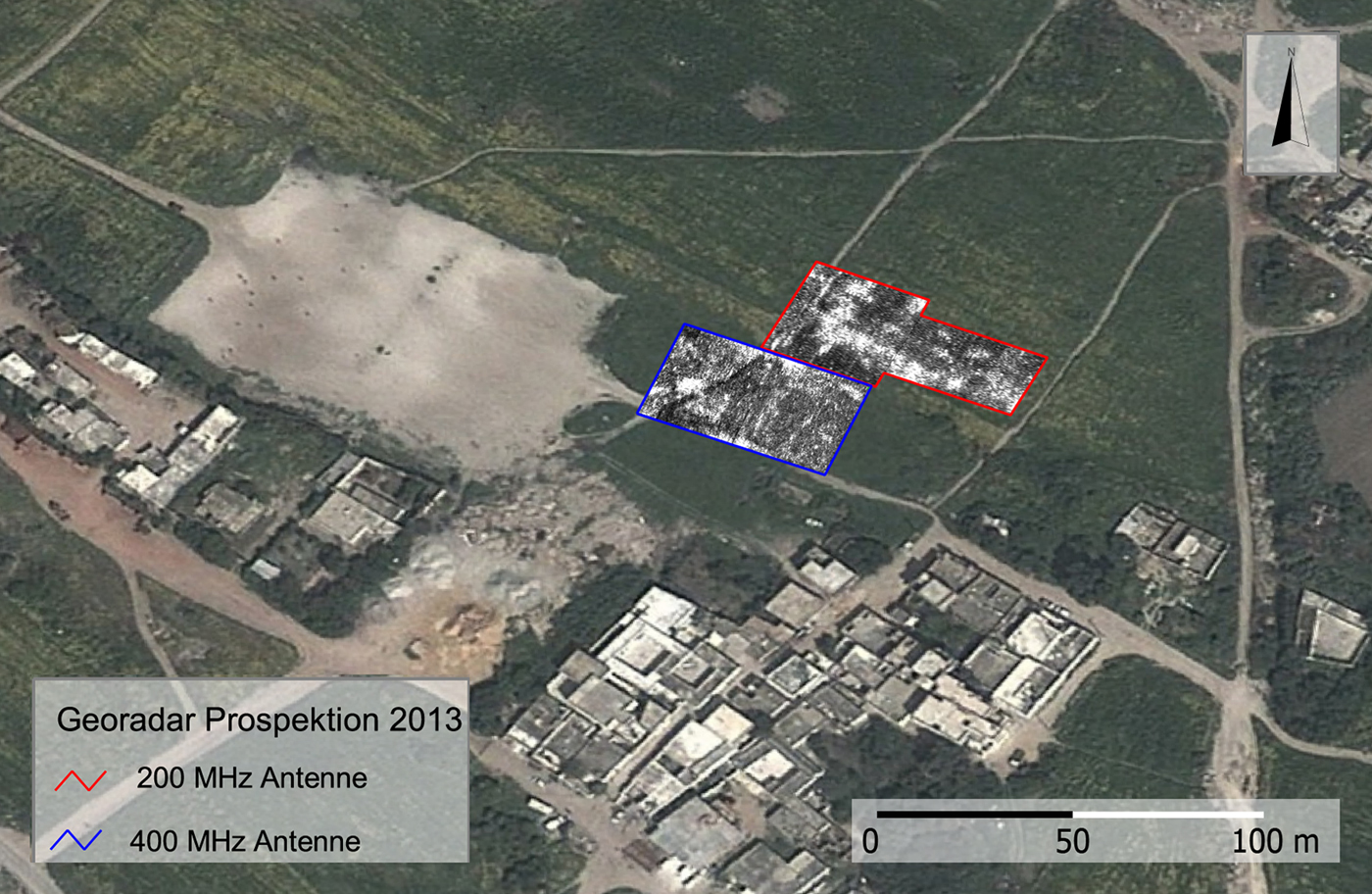
Figure 2. Results of the georadar survey, the upper part using deeper penetrating 200 Mhz antenna in the cavea area, the lower part 400 Mhz antenna in the arena area (M. Broisch).
Several phases predating the erection of the circus are clearly distinguishable in Trench A. Earliest activities, starting in the Middle Punic period, combine cavities worked into the in situ rock and post holes. The system changed several times but continued into the Late Punic period. Stone walls from the latest artisanal/domestic phase were dismantled in the early Roman period. We expect a more detailed distinction between more pre-circus phases in the area in the future with the extension of the existing trenches and the addition of new trenches. The large rectangular structure visible on the georadar image of Trench A turned out to be a block of opus caementicium measuring c. 5.20 × 4.60 m with a height of 1.40 m (Figure 3).
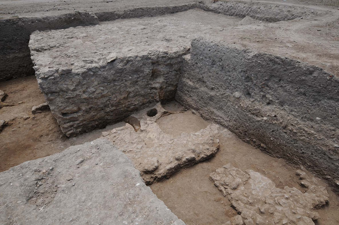
Figure 3. View of the foundation block in Trench A from the northeast, also visible are the predating structures (D-DAI-ROM-KAR-2016.0318, c DAI Rome, R. Bockmann).
It looks very similar to foundation blocks for mausolea in the so-called Yasmina necropolis that had been excavated c. 100 m south of the circus in the 1980s and 1990s by the same American team studying the circus from the University of Georgia. Our foundation block was erected in the second half of the first century AD, dated by pottery from the fill-up layers beneath a levelled thin working surface of yellow sand, into which the pit for the foundation block was dug. With this date, the foundation block in Trench A would be contemporary with the earliest mausolea of the Yasmina necropolis. If our interpretation of a mausoleum is correct for Trench A, it can be supposed that its upper part had originally been constructed of ashlar blocks, like in the mausolea of the Yasmina necropolis. Already about two generations later, in the first half of the second century AD, the mausoleum was carefully dismantled (the foundation block does not show larger destructions but a rather plain and even surface) and the ground filled up to a level above the upper limit of the foundation, coinciding with the upper level of the foundation of the middle barrier of the circus, the spina (Trench C, see below). Apparently, at this point an even surface was created in the whole area as preparation for the arena itself. It has to be pointed out that the deconstruction of a mausoleum and the relocation of a necropolis was unusual. It meant a change in the boundaries of the city and in this case an extension of its limits and a continuation of the necropolis only to the south of the circus beyond the new urban limits.
Trench B was set in the area where the northern spectator ranks were expected. Georadar results here had indicated large straight structures in which an angle was visible, which we thought might have been some kind of passageway. This spot seemed to be the most promising archaeologically and was targeted by the positioning of the trench, which at first was 9 × 10.30 m in dimension. Although these dimensions are very modest, it has to be kept in mind that our aim at this point was to get an idea of the archaeology that could be expected in this area, to be better able to design a larger project. Another important point was to see how reliable georadar surveys could be to target specific crucial points of the monument. The information we obtained exceeded our expectations (Figure 4).

Figure 4. Trench B before the excavation of the large robber trench in the lower part of the trench in 2016; in the upper part preserved late features can be seen (D-DAI-ROM-KAR-2016.0107, c DAI Rome, R. Bockmann).
Only centimetres below the modern surface, late layers predominantly from the seventh century, as far as we can tell at this point, were found intact. The northern and southern half of the trench showed considerable differences in structure. Whereas in the northern part of the trench, a number of features could be distinguished, the southern part basically consisted of a 4.45 m large robber trench extending through the whole length of the trench of 10.30 m, cutting across all earlier features.
The pottery found in the filling of the robber trench predominantly dated to the seventh century with some Islamic sherds (that have not been dated more specifically yet) also present. The robber trench is orientated in an east–west direction, parallel to the arena. Its orientation, largeness and the fact that a cavea seat has also been found in its filling leads us to interpret it as robber trench for one of the foundation walls of the northern cavea. We excavated the robber trench to a depth of 2 m, reaching a level of compacted yellow sand (probably the early Roman preparation layer). A test cut into this layer revealed a stone construction underneath. It is probable that the Roman architects positioned the foundation wall onto a Punic wall (a common practice in early Roman Carthage) to give it more strength whilst avoiding extraction of all of the predating Punic structures. This hypothesis needs testing in further field missions. Abutting the northern front of the robbed out wall, a clear-cut cavity that once contained large ashlar blocks, of which 1.40 m of mortar preserved in the northern profile wall was documented (Figure 5). Charcoal from the preserved mortar has been dated using radiocarbon to the late second/early third century AD (Curt-Engelhorn-Zentrum für Archäometrie, Mannheim, sample 1 1782 BP +/− 34, cal 1-sigma AD 174–326, cal 2-sigma AD 134–338, sample 2 1845 BP +/− 26, cal 1-sigma AD 131–213, cal 2-sigma AD 86–238). As it seems unlikely that the northern cavea as a whole was erected more than 100 years after the arena had been prepared (see above), it seems credible that this part of the foundation had either been restored or enlarged at this point.

Figure 5. Northern section of the ashlar block trench in Trench B, with preserved mortar in the lower part (D-DAI-ROM-KAR-2016.0213, c DAI Rome, R. Bockmann).
The northern half of Trench B showed in its eastern part a paving of large grey slabs in situ, onto which walls had been placed directly that were constructed using mainly spolia. The western of two walls forming a right angle cuts through a number of simple floors/work surfaces conserved in the western part of the northern half of the trench. The upper layers of the floorings were dated to the sixth century AD on the basis of the pottery found in their built-up layers. The walls therefore are rather late interventions dividing up the space of the originally stone slab paving into smaller compartments (Figure 6).
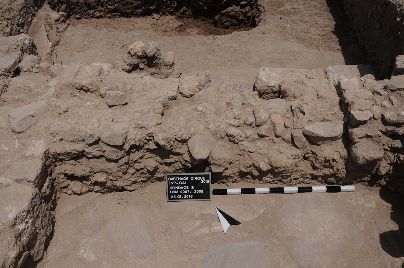
Figure 6. Late walls superposed on the paving slab surface in the northern half of Trench B (D-DAI-ROM-KAR-2016.0050, c DAI Rome, R. Bockmann).
An extension to the north of the western part of the trench established a limit for the stone paving. Beyond the paving, a number of intersecting robber trenches make the situation at this point difficult to interpret with clarity due to the limitations of the excavation so far, however, this part also shows remains of late constructions and a canal, indicating that this part of the trench was already outside of the cavea itself.
A second extension to Trench B was laid out c. 8 m to the south of the original trench where topography indicated the transition from the cavea to the arena (Figure 7). Our goal here was to determine exactly the limits of the spectator ranks to be able to propose a first reconstruction of the extent and ideally a first idea of the architecture of the northern cavea. We were able to define this transition in the form of a conserved part of the arena surface, cut by a robber trench that contained a large amount of architectural spolia. Behind this robber trench was another, shallower but more regular, robber trench with a compact sandy yellow layer as lower limit, similar to early Roman work surfaces we had encountered in other trenches (see above). This feature was interpreted as a trench for the podium wall. The irregular robber trench next to it cutting the arena surface might have removed a drainage canal. At the northern end of the trench, a partly preserved wall of 1 m in thickness seems to constitute the beginning of the cavea substructure.
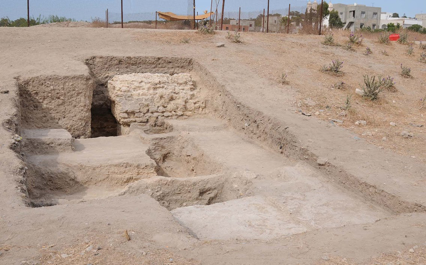
Figure 7. Trench B south. An extension of Trench B at the transition of the cavea and arena (D-DAI-ROM-KAR-2017.0818, c DAI Rome, R. Bockmann).
Between those two, several levels of simple flooring were documented probably constituting the passageway between the podium wall and the lower part of the cavea, from which presumably access to the ranks was possible. These layers give an important indication of the dates in which the circus had been actively curated. Whereas the lower of two flooring levels superposed directly onto each other dated to the first century AD and contained no late pottery fragments at all, the flooring level directly on top of it dated to the late fifth/sixth century AD. This striking chronological gap can be explained only through regular thorough cleaning of the passage down to the original floor, up to the early sixth century. Only then, without further curation of the passage, did the next layer accumulate on top of the old one. An amphora burial had been inserted right next to the inner part of the podium wall apparently at a late date (not yet specified). The burial seems to have been discovered when the podium wall was robbed (at an unspecified point probably in the Medieval period): the top of the amphora was cut away and its contents have apparently been extracted with few remains being left.
Based on the findings described above in Trench B, we can already present some possibilities for the design and extension of the cavea, although clearly further research is needed before we can propose a reconstruction. The arena end of the cavea seems relatively firmly established in the shallow and regular robber trench up to which the arena floor originally ran, which must have contained the podium wall. The second, partly preserved, wall probably served as lower carrier of the cavea itself. In addition, the large robber trench with the protruding ashlar pillar must have contained a cavea wall of considerable size. The cavea seems to have extended to the ashlar paving in its first phase. In a second phase, the ashlar surface was cut to insert the pillar, extending the original cavea in the late second/early third century. It now reached c. 17 m in width. Calculations based on blocks of cavea seats found in the robber trench allow a reconstruction of 20 rows of seats in the cavea, based on the space these would have taken up in the cavea. Architectural fragments from robber trenches further indicate the existence of a porticus on top of the cavea. Further work in the field, including an extension of the trenches, is needed to present a more firmly based reconstruction of the cavea.
Trench C was added in 2016 without a preceding geophysical survey, which was not necessary in this case as it is centred around the remaining part of the western end of the spina, the middle barrier of the arena, still visible protruding from modern surface levels (Figure 8). We cleaned the remains of the spina to be able to study its build-up and put a trench to its northern foundation wall to determine its chronology. In front of its western end, we looked for remains of the meta, the turning point, in another cleaning operation. We were able to determine the exact limits of the spina in its north–south extension not far beyond modern surface level in the form of its outer foundation ring. The deeply founded outer wall measures 1.10 m in width.
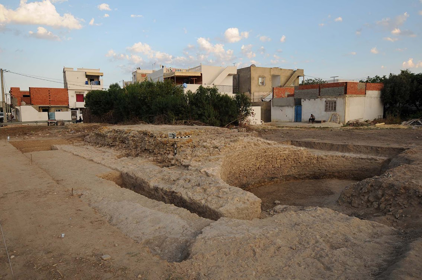
Figure 8. View of Trench C from the northwest: the remains of the middle barrier, the spina (D-DAI-ROM-KAR-2016.0271, c DAI Rome, R. Bockmann).
Pottery from the layers in correspondence with the erection of the outer spina foundation date the building to the late first century AD. The circus therefore was among the earliest Roman public buildings constructed in Carthage. The lower limit of the outer foundation wall has not been reached yet in the trench set to the north of the spina and must exceed a depth of 1.80 m, the current depth of the trench. Built-up layers to support the surface usage of the arena, consisting of very compacted almost mortar-like soil, contained pottery from the first to fifth centuries AD, thereby indicating the active usage period of the arena for chariot racing, in which it needed constant care reflected in the pottery sherds contained. The inner part of the spina is made up of blocks of caementicium positioned inside the surrounding foundation wall. Three layers of caementicium build-up are clearly distinguishable. They do not reach deep into the ground. Remains of hydraulic mortar on the upper parts of the spina’s caementicium core indicate the presence of water basins. The outer foundation ring seems to have held ashlar blocks. In front of the western, crescent-shaped end of the main body of the spina, we were able to identify the remains of the meta. Further work in this area is necessary, though, to determine exact limits and details of its design. In a fill-up layer between the spina and the meta, a number of fragments of architectural decoration were discovered of a relatively small size (Figure 9). These seem to have originally belonged to a structure posed on the middle barrier, maybe a little temple, as was common in this place and is also attested at other circuses.
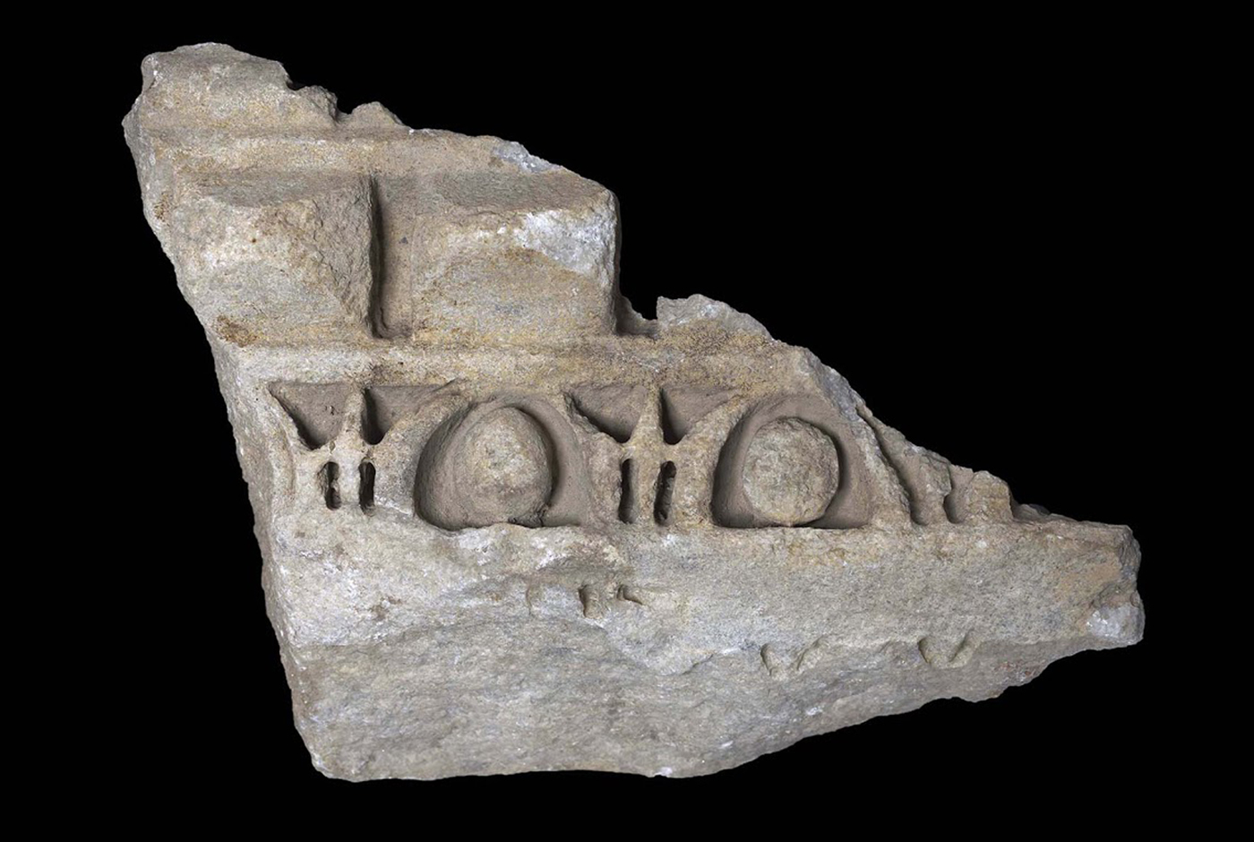
Figure 9. Fragment of architectural decoration originating from the spina, found in the fill-up layer between spina and meta (D-DAI-ROM-2017.0123, c DAI Rome, D. Gauss).
Summary
The three trenches in which we worked so far have already produced results on the evolution and design of the monument that exceed the level of knowledge gained after the Polish and American interventions of the 1970s and 1980s, complementing them for a broader picture of the circus of Carthage (Figure 10). We have established a Punic and early Roman usage of the area before the erection of the monument. The first step in the building of the circus of Carthage was the construction of the outer foundation wall of the middle barrier in the late first century AD, which must have defined the layout of the rest of the monument. The spina was then filled with opus caementicium, containing water basins and architectural decorations, probably small monuments, on top of it. A mausoleum to the northwest of the spina was dismantled and the surrounding terrain filled up to level the arena in the first half of the second century AD. The spectator ranks to the north of the arena consisted – as far as we can say at this point – of a podium wall, a lower foundation wall and at least one other larger foundation wall with pillars. The pillars were an extension of the original cavea in the late second/early third century AD. Either a vaulted corridor or a paved open-air street lined the northern end of the cavea. The cavea reached a width of c. 17 m after its extension. Data in Trenches B and C show a continued usage of the arena and curation of the spectator ranks until the later fifth and early sixth centuries AD. In the sixth century, floor levels kept piling up in the northern cavea, which saw a reorganisation of its space in the seventh century by the insertion of a number of spolia walls. At some point later in its history, many of the walls of the monument were apparently robbed for building material, though these interventions cannot be chronologically specified at this point.
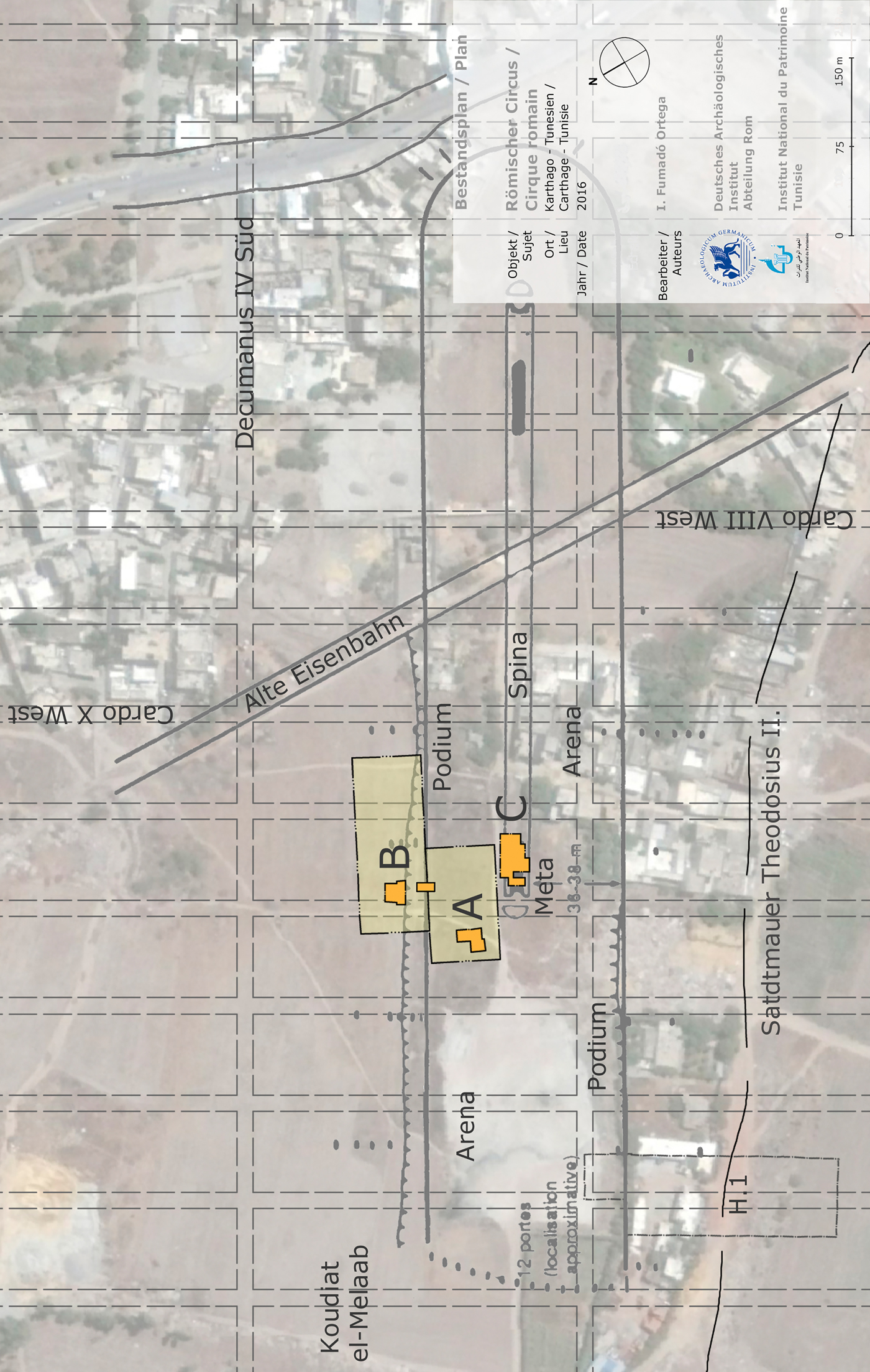
Figure 10. Emplacement of trenches in the terrain; larger boxes around A and B indicate the areas of georadar survey (c DAI Rome, I. Fumadó Ortega).
Further activities
The first results of the project are promising. In fact, the amount of data that could be obtained and the preservation especially of the late layers has exceeded our expectations. The combination of geophysical survey – or, more specifically, georadar – and trenches, even when reduced in size, produces data that allow detailed reconstructions of chronological developments and usage of the terrain that will shed light on the development of this part of Carthage, while at the same time allowing us to limit the trenches to feasible sizes.
The southwestern city quarter is still understudied. Considering that the rest of Carthage has today been practically built up and its ancient urban patterns are in many places only partially known makes the project area even more important for a larger study of urban topography. No early excavations have disturbed the archaeology of the southwestern city quarter, at least not to an extent like in the eastern half of Carthage. By putting the chronology of the circus and other buildings in this area on a sounder footing by systematic radiocarbon dating, we will furthermore be able to re-evaluate the chronology of some of the pottery typologies of Carthage that are basic to North African datings in general.
We have already produced a first stratigraphically secured date for the beginning of the construction of the circus in the late first century AD, that dates the circus earlier than had previously been believed. We were able to show that its construction must have taken place over a longer period of time, with the arena being prepared only in the first half of the second century AD. Considerable work in the northern cavea was carried out in the late second/early third century AD. Usage horizons in two trenches similarly span from the first to the late fifth/early sixth century AD, suggesting that the circus had probably no longer been in use in the Byzantine period, or that at least curation of the monument had stopped at this point. In this era, though, the restructuring of the monument and possible alteration of its functions were well underway.
To complement and extend our first results, we plan a complete georadar study of the wider area, including the arena itself, a second intervention in another part of the northern cavea, a trench to establish the rounded eastern end of the circus and the eastern end of the spina, and another trench to establish the northern connection of the cavea and the starting gates. With these interventions, the circus will be studied in its development and build-up as a whole.
Interventions by F. Chelbi to the north of the circus in the 2000s (Chelbi, Reference Chelbiin press) have already shown that here a diachronic development from middle Punic to Byzantine times can also be studied. Research within the project, especially with its cooperation partners, shall be extended beyond the monument itself. The aim is to achieve a diachronic cross section of the urban history and topography of the southwestern quarter of Carthage. How the erection of the monumental circus was altered and determined its urban context will be studied. Carthage is one of the few places in the Mediterranean where this kind of study is possible. Here, not only can the circus itself be examined, but also the depending infrastructure around it and its connection with the city by roads and water supply. Questions of accessibility and functionality on a broader scale can be answered. The project will thereby considerably extend our knowledge of Carthage and, using the city as a model, further our understanding of ancient urban processes in general. After more detailed publications of our results and their context, it is planned to enter the second stage of the project in 2019 with more substantial funding.
Ultimately, it is also one of the goals of the project to contribute to the preservation and promotion of the area as part of the archaeological zone of Carthage. It is our intention to work with the INP and other Tunisian government institutions to realise a protection and usage plan. The direction taken so far, though only in theoretical considerations, in developing the area into a park and recreational zone including non-intrusive sporting facilities and better connecting the area to the city and other archaeological sites in Carthage seems worthy of support. One can only hope that this important monument receives the scientific and conservational attention it deserves.


