


Introduction
Global warming has significantly impacted the cryosphere in recent decades. According to the fourth Intergovernmental Panel on Climate Change assessment report (Reference SolomonSolomon and others, 2007), there has been considerable mass loss of glaciers and ice caps across the planet since the 1960s. Globally averaged mass balance from glaciers and ice caps from 1960 to 2004 is about -12.2 × 10³ kg m-2 a-1, equivalent to about -14 m of ice. Owing to rising temperatures, glacier mass loss rates from 1990 to 2004 were roughly double those from 1960 to 1990. The global mass loss of glaciers and ice caps is estimated to be 0.50 mm a-1 in sea-level equivalent (SLE) from 1961 to 2004, and 0.77 mm a-1 SLE from 1991 to 2004.
Encompassing the source regions of many large rivers, the cryosphere on the Tibetan Plateau (TP) plays an important role in the water cycle of Southeast Asia (Reference ShiShi, 2001;Reference Yao, Wang, Liu, Pu, Shen and LuYao and others, 2004). Global warming has influenced the environment on the TP significantly over recent decades, causing glacier retreat (Reference Racoviteanu, Williams and BarryRacoviteanu and others, 2008;Reference Kang, Liu, Xie, Li and ShenKang and others, 2009;Reference Schmidt and NusserSchmidt and Nusser, 2009), permafrost degradation (Reference LiLi and others, 2008;Reference Liu, Wang, Yu, Yang and ZhangLiu and others, 2009), snow-cover decrease (Reference Qin, Liu and LiQin and others, 2006; Reference SolomonSolomon and others, 2007), etc. It is estimated that glaciers in western China underwent a 5.5% area loss (Reference Kang, Liu, Xie, Li and ShenKang and others, 2009), and their mean thickness decreased by 6.8 m from 1960 to 2000 (Reference Yao, Wang, Liu, Pu, Shen and LuYao and others, 2004). Consequently, the glacial mass loss since the 1990s has caused an increase of 5.5% in river runoff and a change in hydrological processes in northwestern China, particularly on the TP (Reference Yao, Wang, Liu, Pu, Shen and LuYao and others, 2004, 2007).
Negative mass balance of glaciers and ice caps can lead to the growth of inland lakes (Reference YaoYao and others, 2010). However, it is difficult to evaluate the impact of glacier mass loss on lake-level rise since not all the glacier meltwater is transferred into lakes. Glacier meltwater experiences evaporation and catchment infiltration before reaching lakes. In studies of sea-level rise, glacier mass loss and sea-level rise are usually directly compared, assuming that the mass loss of glaciers and ice caps is entirely transferred to the ocean (Reference SolomonSolomon and others, 2007).
The TP encompasses the world’s largest group of high- altitude lakes, with a total lake area of ˜40 000km2, accounting for nearly half of the total lake area in China (Reference GuanGuan and others, 1984). Many studies show that lakes on the central TP expanded slightly between 1970 and 2000, but expanded dramatically after 2000 (Reference Kang, Liu, Xie, Li and ShenLiu and others, 2009; Reference Bian, Bian, La, Wang and ChenBian and others, 2010;Reference Wan, Xiao, Feng, Li, Ma and DuanWan and others, 2010;Reference Zhu, Xie and WuZhu and others, 2010). The increase in lake area over the past 10 years is much larger than that between 1970 and 2000, the causes of which remain unclear.
In this study, we evaluated the impact of glacier mass loss on the growth of Linggo Co (‘Co’, pronounced ‘tso’, is the Tibetan word for lake), an inland glacier-fed lake on the central TP, by comparing the variations of this lake with the surrounding non-glacier-fed lakes between the 1970s and 2010. Lake volume variations were estimated from lake boundaries at different stages and bathymetric data from field investigations. Glacier volume variations were obtained by calculating glacier surface elevation differences between the 1970s and 2000. This study provides insight into the influence of glacier mass loss on lake growth on the TP over the past four decades.
Study Sites
Linggo Co lies within an 1830 km2 closed basin west of the Tanggula Mountains on the central TP (Fig. 1). Meltwater from the Puruogangri ice field, 40 km to the east, is its primary water source. In 1974, the lake had a surface area of ˜95 km2 at ˜5060 m a.s.l. The Puruogangri ice field has an area of ˜422.6km2 (Reference Pu, Yao, Wang, Ding and ZhangPu and others, 2002;Reference Yi, Li and QuYi and others, 2002), of which 135 km2 lies in the catchment of Linggo Co. Owing to harsh natural conditions, the region is virtually uninhabited. Tuotuohe meteorological station, the closest station to Linggo Co, is located about 330 km to the northeast. According to a regional map (Reference Sun, Liao and Pan Yand WangSun and others, 1990), the mean annual temperature around Linggo Co is about -6°C, and the mean summer temperature is close to 0°C. Total annual precipitation is estimated to be 150— 200 mm, with 70-80% of snowfall occurring in the summer (Reference Li, Yi, Chen, Yao and LiLi and others, 2006).

Fig. 1. Location of the study area. Yellow lines are the lake catchment boundaries.
Other lakes in the vicinity of Linggo Co include Longwei Co, Amur Co and Darngo Co Ngion (Fig. 1). Longwei Co, about 20-30 km west of Linggo Co (Fig. 1), had a surface area of ˜44 km2 in 1973 and an elevation of ˜4924 m. This lake has a catchment area of 1200 km2, with gentle slopes to the east and a large alluvial fan to the west. There is no glacier in the catchment of Longwei Co. South of Linggo Co, a low bank several meters in height separated Darngo Co Ngion from Amur Co before 1999, but satellite imagery in 2006 shows that they became a single lake due to lake-level rise. Darngo Co Ngion and Amur Co share a catchment area of 2740 km2 and in 1971 had surface areas of ˜41 and ˜34km2 respectively. Several small glaciers, with a total area of about 8 km2, are distributed in the catchment of Amur Co and Darngo Co Ngion.
Data and Methods
Remote-sensing data
Satellite images were used to monitor lake and glacier changes. We acquired six scenes of Landsat images, including one Multispectral Scanner (MSS) image on 2 December 1976, one Thematic Mapper (TM) image on 30 September 1992 and four Enhanced Thematic Mapper Plus (ETM+) images on 25 August 1999, 21 September 2003, 29 September 2006 and 7 August 2010. All satellite images were co-registered to 1:100000 topographic maps produced from early 1970s aerial photography. The coregistration errors to the maps were within one image pixel. All map and image data were projected into the UTM (Universal Transverse Mercator) coordinate system zone 45 using the WGS84 geodetic datum. Glaciers and lakes on the 1 : 100 000 scale topographic maps and sequential Landsat images were extracted in the false-color image by on-screen digitizing with manual delineation using ArcGIS 9.2 software. The accuracy of manual digitization was controlled within one pixel.
It is more challenging to extract glacier boundaries than lake boundaries because glaciers are often covered by snow at high elevations (Reference Ye, Yao and NaruseYe and others, 2008). In 1999 and 2007 images, a ˜10 km long section of the southwest Puruogangri ice field was covered by snow, which made it difficult to differentiate the glacier boundary. For this study, we assumed that the glacier boundary remained unchanged, and used the same data at different stages for the snow-covered portions to calculate the glacier area. The boundaries of glacier tongues that are covered by debris are usually difficult to detect. However, field investigation shows that debris does not cover the glacier snouts on the western side of the Puruogangri ice field (Reference Pu, Yao, Wang, Ding and ZhangPu and others, 2002).
We used digital elevation model (DEM) data from 1974 and 2000 to evaluate the glacier mass loss. The DEM of 1974 (hereafter DEM10) was created by digitizing 40 m equidistant contour lines on 1 : 100000 topographic maps. The DEM from 2000 was Shuttle Radar Topography Mission (SRTM) version 4.1, obtained from the Consortium for Spatial Information of the Consultative Group for International Agricultural Research (CGIAR-CSI) SRTM 90 m database (http://srtm.csi.cgiar.org/). The voids in SRTM in this version were filled prior to download using methods described by Reference Reuter, Nelson and JarvisReuter and others (2007). The Puruogangri ice field study area was free of voids in comparison with the original data of the SRTM DEM. In order to eliminate the possible impact of geometric errors between the two DEMs, the SRTM was coregistered to DEM10 (Reference Wang, Yang and YaoWang and others, 2012). The elevation change of the ice field from 1974 to 2000 was obtained by subtracting the DEM10 from the SRTM.
It is important to note that there is some uncertainty in deriving glacier elevation change using DEM comparisons. The standard deviation, SD, in non-glacial areas can be used as a first estimate of the uncertainty, but will probably overestimate it (Reference Berthier, Arnaud, Kumar, Ahmad and Wagnon Pand ChevallierBerthier and others, 2007). Here we use the standard error, SE, and the mean elevation difference, MED, in non-glacier areas as an estimate of the uncertainty, e, according to the law of error propagation (Reference KobletKoblet and others, 2010;Reference Nuth and KaabNuth and Kaab, 2011)
SE is defined as the SD of non-glacial areas divided by the square root of the degree of freedom (sometimes called ‘effective sample size’). MED can be considered to be the systematic uncertainty of volume changes for the corresponding time period, while SE is the corresponding stochastic uncertainty. In calculating MED we took all the non-glaciated DEM gridcells into consideration, and while calculating SE we assumed an autocorrelation distance of 1.8 km (20 pixels) (Reference KobletKoblet and others, 2010). The error in elevation differences for the glaciated areas was estimated to be ±1.91 m. Volume change was calculated according to the glacier area in 1974, assuming that the density profile remained unchanged. To convert volume change into mass change, we assumed an ice density of 900 kg m-3.
Field investigations
Field campaigns to the lakes were conducted in November of 2009 and 2010. Three bathymetric transects in Linggo Co were surveyed at intervals of 50-100 m perpendicular to the shoreline, where the slope of the lake bed is relatively gentle (Fig. 2). The water depth was determined using an ultrasonic instrument (MD-100) with an uncertainty of less than 0.3%. Lake-level variations were determined according to the lake boundary at different stages and the bathymetric profile survey in 2010/2009, with the lake level in 2010/2009 as the reference. The lake boundaries were determined with an uncertainty of one pixel for TM and ETM+ images (28.5 m). The error range of these measurements suggests that the accuracy of our calculated lake-level variation is adequate for evaluating the lake evolution along three long transects.

Fig. 2. The growth of Linggo Co between 1974 and 2010, and three bathymetric profiles perpendicular to the shoreline (a, b, c). The gray area shows the lake water in 2010. The lake boundaries in 1974, 1992, 1999 and 2006 are also marked. The red dots indicate the sites for water depth measurement.
Results and Discussion
Lake changes
The area of Linggo Co increased by a total of 20.26 km2 (21.34%), with the rate of growth accelerating between 1974 and 2010 (Table 1; Fig. 3). The lake area was 94.95 km2 in 1974 and increased by 2.64 km2 (2.78%) from 1974 to 1992. It continued to increase, by 3.76 km2 (3.96%), from 1992 to 1999. Between 1999 and 2010, the lake area increased significantly by 13.86 km2 (14.60%), at a much higher rate than during previous observational periods.
Table 1. Lake area (km2) of Linggo Co, Longwei Co, Amur Co and Darngo Co Ngion at different stages


Fig. 3. The lake area ratios of the four studied lakes at different stages, compared with the early 1970s (see Table 1).
Lake-level variation was reconstructed according to the lake boundaries at different stages and the corresponding water depth in 2009/2010 (Fig. 4). The water level of Linggo Co rose by 1.5 m (8.3 cm a-1) between 1974 and 1992, by 3.0 m (42.8 cm a-1) between 1992 and 1999, and by 6.70 m (60.9 cm a-1) between 1999 and 2010. Thus, Linggo Co rose by 11.2 m between 1974 and 2010, and the most prominent increase in lake level occurred between 1999 and 2010.

Fig. 4. Changes in lake level and volume of Linggo Co between 1974 and 2010, compared with 1974.
By assuming for simplicity that the lake basin is coneshaped, the variation of lake volume can be expressed as
where S1 and S2 are the lake area at two stages and h is the change in water level. Based on the lake area at different stages and lake-level variation, we estimated that the lake volume of Linggo Co increased by 1.44 × 10⁸m3 (8.02 × 10⁶m3a-1) between 1974 and 1992, by 2.98 × 10⁸m3 (42.67 × 10⁶m3a-1) between 1992 and 1999, and by 7.24 × 10⁸ m3 (65.82 × 10⁶ m3 a-1) between 1999 and 2010 (Fig. 4). The rate increase of lake volume between 1999 and 2010 was 1.5 times greater than that between 1992 and 1999, and 8 times greater than that between 1974 and 1992.
Similarvariationsof Longwei Co, AmurCoand DarngoCo Ngion were observed between the 1970s and 2010, but the variations for these three lakes were different from those in Linggo Co (Table 1; Fig. 3). Longwei Co, Amur Co and Darngo Co Ngion had areas of 44.45, 34.57 and 41.41 km2 respectively in 1973/1971, and between 1973/1971 and 1992 the lake areas decreased significantly by 18.06 km2 (40.63%), 16.39 km2 (47.41%) and 11.51km2 (27.80%) respectively. Thus, area changes of the three lakes were opposite in sign to that of Linggo Co before 1992. Between 1992 and 1999, the three lakes expanded dramatically by 18.97 km2 (42.68%), 11.58 km2 (33.50%) and 4.64 km2 (11.20%) respectively. Between 1999 and 2006, they continued to grow by 8.60 km2 (19.35%), 18.21km2 (52.67%) and 13.39km2 (32.33%) respectively. After 2006, the area of Longwei Co increased by 2.28 km2, and the area of Amur Co and Darngo Co increased by a total of 13.30 km2. Owing to the small shoreline gradient, the rates of surface area change for the three lakes were greater than that of Linggo Co.
Glacier changes
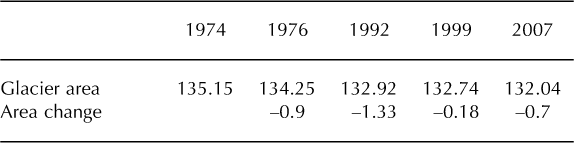
The glaciers in the catchment of Linggo Co cover an area of 135 km2 or 7.4% of the basin area, and provide significant water inflow to Linggo Co. Between 1974 and 2007, the glacier area in the catchment of Linggo Co decreased by 3.22 km2 or 2.4%. The rate of area loss decreased from 0.3 km2 a-1 to 0.026 km2 a-1 between 1974 and 1999, but increased to 0.087 km2 a-1 between 1999 and 2007 (Table 2). As a continental-type glacier, Puruogangri ice field retreated at a much slower rate than the average rate of 5.5% for TP glaciers between 1960 and 2000 (Reference Kang, Liu, Xie, Li and ShenKang and others, 2009).
Table 2. Changes in glacier area (km2) in the catchment of Linggo Co
The surface elevation difference of Puruogangri ice field varied from -212 m to 132 m, with a mean value of -6.19 ± 1.91 m between 1974 and 2000 (Fig. 5). The decline of surface elevation mainly occurred in glacier tongue regions, and the increase in surface elevation mainly occurred in glacier interiors. The center of Puruogangri ice field is a wide and flat plateau with an area of over 150 km2 and an elevation exceeding 5800ma.s.l. Despite climate warming, it is still an accumulation zone, while ablation has greatly increased in the lower glacier regions. Total glacier mass loss in the catchment of Linggo Co is calculated to be (7.52 ±2.32)x108m3w.e. between 1974 and 2000.

Fig. 5. The surface elevation difference of Puruogangri ice field between 1974 and 2000. The inset is the histogram of the SRTM DEM (2000) minus DEM10 (1974). Positive values indicate glacier thickening, and negative values indicate glacier thinning.
There are only limited records of continuous glacier mass- balance measurement on the TP due to its remote location and high elevation. On the central TP, the mass balance of Xiao Dongkemadi glacier (33°04’ N, 92°05’ E) in the Tanggula Mountains has been monitored since 1989, and the results reveal that the average ice thickness increased by 1.8m between 1989 and 1994, but decreased by 3.5 m between 1994 and 2002 (Reference PuPu and others, 2008). Long-term observations of Orumqi glacier No. 1 (43°050 N, 86°50’ E) at the headwaters of the Orumqi river show that glacier thickness decreased by about 8 m between 1958 and 2000 (Reference Li, Han, Jing, Yang and JiaoLi and others, 2003). Based on the field surveys of glacier boundary utilizing differential GPS and glacier depth by ground penetrating radar, Reference Ma, Tian, Pu and WangMa and others (2010) calculated the mass balance of Kangwure glacier (28°270 N, 85°45’ E) in the central Himalaya to be -7.5 m between 1974 and 2008. Although Puruogangri ice field is an extremely continental- type glacier (Reference Shi and LiuShi and Liu, 2000), the mass loss was only slightly less than that of other glaciers on the TP during the past few decades, which indicates that continental-type glaciers also experienced significant mass loss, although the area change was much smaller than for maritime glaciers.
Causes of lake growth
For closed lakes, the main factors influencing the water balance include precipitation, evaporation and runoff. The annual precipitation at Tuotuohe station, located about 330 km northeast of Linggo Co, decreased significantly from 1970 to 1984, reached a mimimum between 1984 and 1995 and has increased considerably since 1997 (Fig. 6). The 20cm pan evaporation showed high values between 1987 and 1996, and low values between 1997 and 2005. For the non-glacier-fed lakes, the lake area (Fig. 3) varied in the same pattern as the precipitation. The shrinking stage between the 1970s and 1992 corresponded to the decrease in precipitation, while the expanding stage corresponded to the increase in precipitation between 1998 and 2005.

Fig. 6. Time series of annual temperature, precipitation and 20cm pan evaporation between 1970 and 2005 at Tuotuohe meteorological station, which is located about 330 km to the northeast of Linggo Co (Fig. 1).
Despite being in the same climate region, Linggo Co evolved differently from the other three lakes. The area of the three non-glacier-fed lakes in 2000 was close to that in the early 1970s, but shrank significantly between the 1970s and 1992, indicating that the lake water experienced a considerable deficit. The water level of Linggo Co rose by 5.1m and the lake volume increased by 5.0 × 10⁸m3 between 1974 and 2000. Assuming similar climate changes occurred in Linggo Co, the lake growth was mainly attributed to the increased influx of glacier meltwater between 1974 and 2000. As we have shown, the glacier mass loss in the catchment of Linggo Co is calculated to be (7.52 ± 2.32) × 108m3w.e. between 1974 and 2000. The increase in lake volume of Linggo Co corresponded to ˜66% of the glacier mass loss during this period. This suggests about one-third of glacier meltwater was consumed by evaporation and recharged to groundwater, which is not a small portion of the water budget in the catchment of Linggo Co. We attribute this consumption to the significantly negative water balance between 1974 and 1992, which has been indicated by the significant shrinkage of the nonglacier-fed lakes.
Linggo Co and the other three lakes all expanded significantly between 2000 and 2010, which indicates that not only glacier mass loss but also climate change (i.e. an increase in precipitation and/or decrease in evaporation) contributed to the growth of Linggo Co. Many studies show that glacier mass loss accelerated during the past 10 years (Reference Yao, Wang, Liu, Pu, Shen and LuYao and others, 2004; Reference Bamber and RiveraBamber and Rivera, 2007; Reference Paul, Kaab and HaeberliPaul and others, 2007; Reference Yang, Yao, Xu, Wu, Ma and XinYang and others, 2008; Reference Kang, Liu, Xie, Li and ShenKang and others, 2009). Globally averaged ice mass loss between 1990 and 2004 was double that between 1960 and 1990 (Reference SolomonSolomon and others, 2007). Here we assume that the glacier mass loss of the Puruogangri ice field between 2000 and 2010 was also double the loss between 1974 and 2000, and 70% of the glacier mass loss was transferred into Linggo Co. Based on these assumptions, we calculate the contribution of glacier mass loss to the lake-level rise of Linggo Co to be 3.6 m, or about 60% of the total lake-level rise, between 2000 and 2010.
Comparing the contribution of glacier mass loss to lake- level rise, we find that the glacier mass loss has a great impact on the rapid growth of Linggo Co. During the drier period of 1974-99, glacier mass loss was larger than the increase in lake volume because it not only increased the lake level of Linggo Co significantly, but offset the negative water balance (the decrease in precipitation and the increase in evaporation). Meanwhile, during the wetter period of 1999-2010, although the increase in precipitation and decrease in evaporation could have contributed considerably to the lake-level rise, glacier mass loss contributed more than half of the lake-level rise.
Conclusions
Based on water depth measurements in conjunction with remote-sensing and GIS techniques, we reconstructed the lake-level variations of Linggo Co, a glacier-fed lake on the central TP. Results show that the lake level increased by 1.5 m between 1974 and 1992, by 3.0 m between 1992 and 1999, and by 6.7 m between 1999 and 2010. Three other lakes in the surrounding region (i.e. Longwei Co, Amur Co and Darngo Co Ngion), which are mainly fed by precipitation, shrank between the early 1970s and 1992 and expanded significantly between 1992 and 2010. Despite being in the same climate region, Linggo Co evolved differently from the other three lakes.
As a lake supplied predominantly by glacier meltwater, the growth of Linggo Co was mainly due to the negative mass balance of the Puruogangri ice field. The glaciers in the catchment of Linggo Co decreased in area by 2.4% from 1974 to 2007, and their mean thickness decreased by 6.19 ± 1.91m between 1974 and 2000. These changes were associated with (7.52 ± 2.32) × 108m3 of glacier meltwater runoff. This study indicates that glacier mass loss not only compensated for the negative balance of the lake water under a relatively drier climate, but also contributed significantly to the lake-level rise between 1974 and 2010.
Acknowledgements
This research was supported by the External Cooperation Program of the Chinese Academy of Sciences (CAS; GJHZ0960), the CAS/SAFEA (State Administration of Foreign Experts Affairs) International Partnership Program for Creative Research Teams (KZCX2-YW-T11), The National Natural Science Foundation of China (NSFC) project (40810019001, 40730101 and 41101062) and the NASA New Investigator Program (NNX06AE58G). We thank Pan Baolin, Dong Guocheng and Ma Qingfeng for conducting the fieldwork. We are also grateful to Graham Cogley and an anonymous reviewer for constructive comments on the manuscript.


