


Introduction
Located in Victoria Land, at the limit between a more glaciated icefield region with valley glaciers to the north and a less glaciated area (leading to the Dry Valleys) with outlet glaciers to the south, upper Rennick Glacier basin is considered of particular interest for the glacial history of the East Antarctic ice sheet (Reference Denton, Bockheim, Wilson, Schluchter and StumpDenton and others, 1986). Rennick Glacier (Fig. 1) flows from the Transantarctic Mountains in a north-northwesterly direction into the Southern Pacific Ocean. The western upper section of the glacier receives ice from Rennick Neve and from Talos Dome. In this upper section of the glacier several nunataks emerge from the ice, where geomorphic observations can help to trace the history of the glacier (Fig. 2). In this paper we discuss mainly a geomorphological survey of the nunataks of the Lichen Hills. Ice-surface levels higher than at present were reconstructed from the evidence of erosional trimline, glacial striae, erratics and glacial deposits in the ice-free areas. A crucial and not yet resolved problem is the age of the upper limit of glaciation, and of the polished and striated surfaces, as well as the history of the glacial shrinkage from the Last Glacial Maximum (LGM).
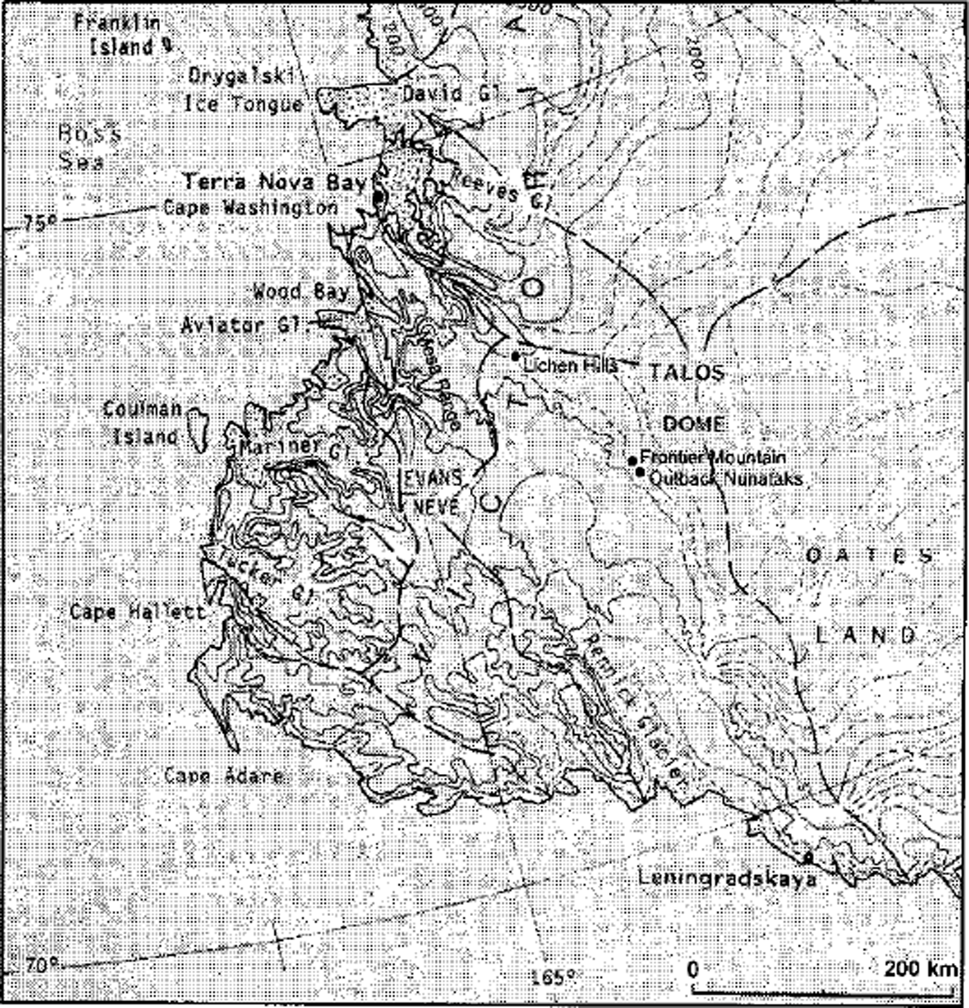
Fig. 1. Rennick Glacier and northern Victoria Land.
At the foot of the outcropping hills, where blue ice is present, supraglacial drift often shows bands of different lithology, with light-coloured granitic rocks alternating with dark-coloured volcanic rocks. We inferred that the formation of the strips was due to the progressive reduction of the ice from its last maximum level to the present, in conjunction with the exposure of different rock units. The lowering of the glacier surface is shown by scattered, slightly weathered, erratic blocks on the top of the hills and by glacial deposits found at various levels. Polished and striated rocks with crescentic gouges are frequent on the granitic surfaces (Fig. 2).
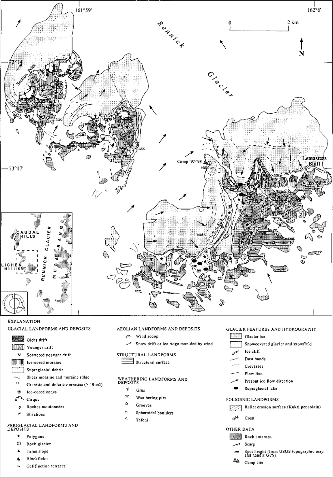
Fig. 2. Geomorphological sketch map of the Lichen Hills, upper Rennick Glacier.
The glacial reduction model proposed in this paper is derived from the investigations carried out by the authors during field expeditions in 1993-94, 1995-96 and 1997-98, with camps in upper Rennick Glacier region. Meteorite research was carried out at Frontier Mountain, along with investigations on the blue-ice areas of the Outback Nunataks and detailed geomorphological and glaciological surveys of the Lichen Hills and Section Peak.
Geologic and Geomorphologic Framework
The bedrock geology of the upper Rennick Glacier area has been investigated during numerous expeditions; in this paper we refer to the geological map published by Reference CarmignaniCarmignani and others (1988). The glacial history has been studied by many researchers, including Reference MayewskiMayewski (1975, Reference Mayewski1982), Reference Mayewski, Attig and DrewryMayewski and others (1979), Reference Denton and HughesDenton and Hughes (1981), Reference DentonDenton (1982), Reference Denton, Bockheim, Wilson, Schluchter and StumpDenton and others (1986), Reference HofleHofle (1989), Reference Orombelli, Baroni and DentonOrombelli and others (1990), Reference Van der Wateren, Verbers, Yoshida, Kaminuma and ShiraishiVan der Wateren and Verbers (1992a,Reference Van der Wateren and Verbersb) and Reference DelisleDelisle (1993). From the literature one can deduce that in the past some of the mountains in the upper Rennick Glacier area were overridden by ice. For example, glacial striae were found by Reference HofleHofle (1989) at the top of Frontier Mountain at 2804ma.s.l. and by Reference Denton, Bockheim, Wilson, Schluchter and StumpDenton and others (1986) on the upper surface of Miller Butte at 2600ma.s.L, while erratics were observed on the top surfaces of the Lichen Hills. However, the age at which the overriding by ice took place has not been satisfactorily established (Reference Denton, Bockheim, Wilson, Schluchter and StumpDenton and others, 1986; Reference Orombelli, Baroni and DentonOrombelli and others, 1990).
Rennick Glacier is a large glacier at the western margin of northern Victoria Land and it flows in a north-northwesterly direction into the Southern Pacific Ocean along an extensional graben structure of the Transantarctic Mountains. It is > 300 km long, up to 35 km wide in its trough sector and drains a basin of about 54 000 km2. In its upper section, Rennick Glacier drains from the east the ice coming from Evans Névé and the Mesa Range. From the west the ice comes from Rennick Neve and from Talos Dome, a culmination of the East Antarctic ice sheet. In the upper section of the glacier, isolated nunataks outcrop from the ice, whilst other buried mountains can be inferred from bulges, crevasses and other features on the ice surface. The rocks of the nunataks belong to two main complexes. The lower complex is composed of granitic rocks of the Granite Harbour Intrusives (Ordovician) and of high-grade metamorphics of the Wilson Terrane, possibly pre-Cambrian, which are cut by a horizontal erosional surface known as the Kukri Peneplain. The second complex of rocks, the Ferrar Supergroup volcanics and the Beacon Supergroup sandstones, was deposited over this erosional surface. The Ferrar Supergroup includes the Kirkpatrick Basalt, generally interpreted as lava flows, and the Ferrar Dolerite sills. The Beacon Supergroup outcrops close to the bottom of the Ferrar Supergroup as the Section Peak Formation, and it is a thin layer of sandstone, locally fossiliferous, deposited by braided streams. The volcanics are dark-coloured, whilst the sandstone, granitic and metamorphic rocks are light-coloured, so the debris coming from each can be clearly identified by the strong contrast in colours.
The nunataks of the west side of the uppermost Rennick Glacier are aligned in a south-southeasterly-north-northwesterly direction and decrease in altitude from about 3000 m to the south to 2400 m to the north. The nunataks are separated by glacial flows coming from the ice divide between the Rennick Glacier and Priestley Glacier basins, and from Rennick Neve.
The nunataks have a uniform morphology, with the volcanic layers creating a flat-topped, cuesta-like form, partially covered by ice. The eastern slope of the front of each cuesta is steep in its upper part, mainly where columnar basalts outcrop. The slope is interrupted where the erosion exhumed the Kukri Peneplain and formed structural terraces. Where the erosion has sculptured the granitic and metamorphic rocks, an Alpine morphology with peaks and saddles is present. In plan view a complex morphology can be observed, with deep cirque-shaped gulfs on the northeast side whose bottoms are filled by blue-ice tongues flowing back from Rennick Glacier.
The Lichen Hills
The Lichen Hills are composed of two distinct nunataks, divided by a glacial flow. To the north there is Section Peak, which is itself divided into two parts by a small glacier flowing north-northeast. To the south of the Lichen Hills proper is an arch-shaped hill (in plan view) with the concavity to northwest, whilst a slope with three spurs faces Rennick Glacier. The eastern spur is called Lemasters Bluff. The spurs embrace two gulfs, with the western one more deeply developed. Blue ice enters these two gulfs from Rennick Glacier where it is strongly ablated by katabatic wind, blowing mainly in a northerly direction. This can be clearly seen in the western gulf, where the blue-ice lobe slopes to the south and forms a closed depression with a small frozen lake at its snout. The location and extent of the blue-ice areas are directly related to the prevailing wind direction and the topography; on the lee side of the nunataks the strong atmospheric turbulence enhances ablation, forcing the ice to converge and to flow back.
The morphology is strongly influenced by the structural conditions. The top of the hills comprises wide tabular flats following the attitude of the volcanic layers. Here, where the surface is ice-free and covered by debris, a net of periglacial polygons and block fields has developed. On bare rocks, weathering pits are present, and near to the terrace border there are locally brittle chiselled forms a few tens of cm high. On the top surface of the Lichen Hills scattered, little-weathered granitic erratics were found (Fig. 3). Towards Rennick Glacier the layers of the Ferrar Supergroup form very steep slopes that become vertical where columnar joints are present. Scree cones and talus cover the lower part of the slope. Near the base of the volcanic rocks, an outcrop of sandstone layers of the Beacon Supergroup is observed (Reference Di Giulio, Casnedi, Ceriani, Ortenzi, Rossi and RicciDi Giulio and others, 1997). Their thickness is small compared to that of the volcanic rocks, although locally the sandstone forms structural walls.
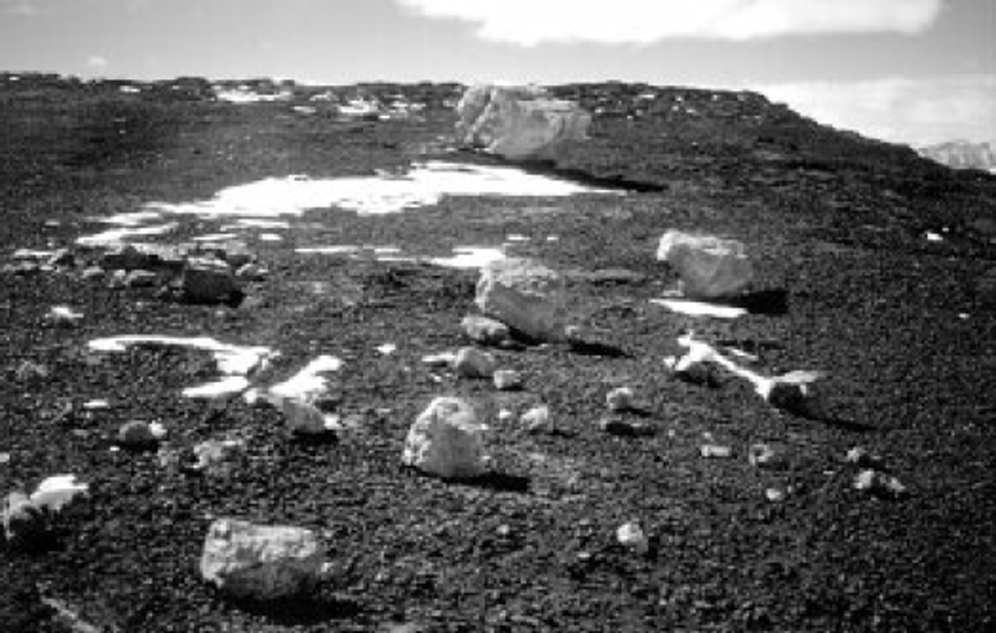
Fig. 3. Slightly weathered, angular to subangular erratic blocks of granite resting on weathered Ferrar Supergroup bedrock, on the tabular summit of the Lichen Hills. The blocks are comparable to the exposed granitic blocks of the Terra Nova drift (Late Wisconsin) in northern Victoria Land due to the absence of staining, oxidation patinae and cavernous weathering.
Locally, under the slope on the volcanic rocks, a terrace has developed on the exhumed Kukri Peneplain. The surface is gently undulating and the rock is deeply weathered, with pits and pseudo-karstic grooves. In some places the surface was moulded by the ice as roches moutonnees with polished surfaces, striae and crescentic gouges, and is covered by scattered glacial drift. A few moraines of volcanic rocks deposited by local glaciers were detected on these terraces. All this evidence suggests an old morphology, deeply affected by weathering and only slightly modified by recent glacial processes.
The terraces on the Kukri Peneplain have steep slopes and rock walls down to the present level of the Rennick Glacier ice. Where the erosion of these slopes was greater, an alpine morphology with peaks and sharp aretes developed, as in the northern part of Section Peak, in the spur near the 1997-98 camp and in the ridges of the Caudal Hills. Thick glacial deposits can be seen on these slopes, and a belt of glacial drift on the spur west of Lemasters Bluff is of particular interest (Fig. 4). It is composed of a clast-supported diamicton with angular and subangular clasts of granite, metamorphic rocks, dolerite and Beacon sandstone. Clasts are fresh and little-stained, and the sandy matrix is olive grey in colour. The surface is unstable and a network of coarse polygons is often present. Perched blocks are common, locally directly resting on weathered and oxidised glaciated granite bedrock. On the basis of both the morphology and the low degree of weathering, the glacial drift near Lemasters Bluff can be correlated with the Terra Nova drift described on the contiguous coastal area by Reference Orombelli, Baroni and DentonOrombelli and others (1990) and attributed to the Late Wisconsin on the basis of radiocarbon dates.
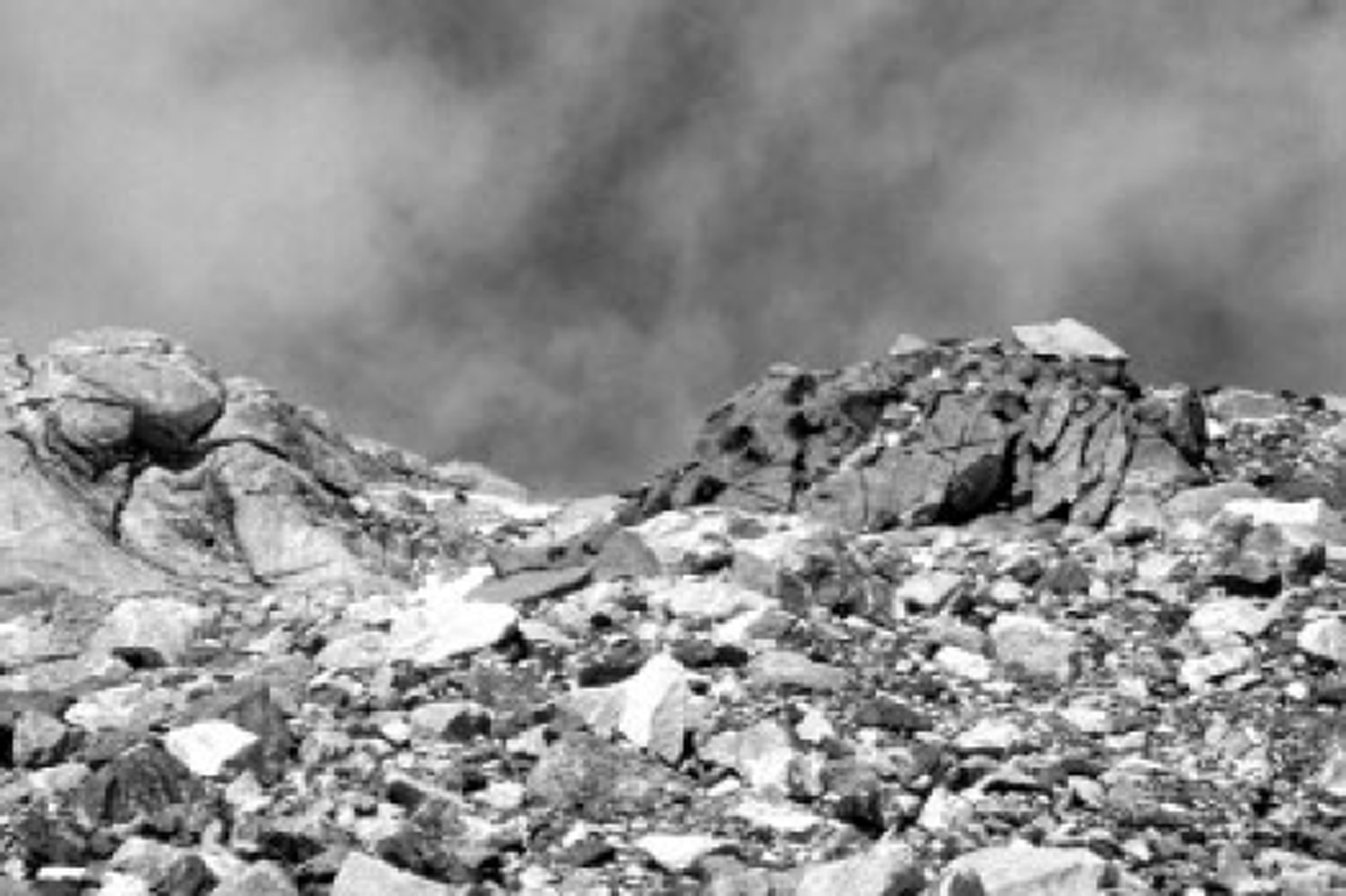
Fig. 4. Late Wisconsin glacial drift deposited by a blue-ice tongue from Rennick Glacier on weathered glaciated granite bedrock, west of Lemasters Bluff Notice the fresh angular clasts of granite and a perched block on a bedrock knob.
We deduced that the belt of glacial drift on the spur west of Lemasters Bluff was deposited by a blue-ice glacial tongue coming from Rennick Glacier and was stranded against the northern slope of the Lichen Hills. The process is similar to that presently acting at a lower elevation. Under the belt of glacial drift, where it forms a thin, discontinuous veneer, an older drift is locally preserved, as can be inferred by the greater oxidation of the clasts and of the sand matrix, and by the presence of salt flecks. The two drifts suggest a complex glacial history, with repeated fluctuations of the ice level.
There are frequent patches of supraglacial debris with parallel ridges resting on blue ice (ice-cored moraines) near the base of the hill slopes. Distinct strips of different lithology can be observed, mostly detectable by the difference in colours (Fig. 5); this can be seen even on aerial photographs. The direction of the ridges is parallel to that of dust bands in the blue ice, both perpendicular to the direction of the ice flow.
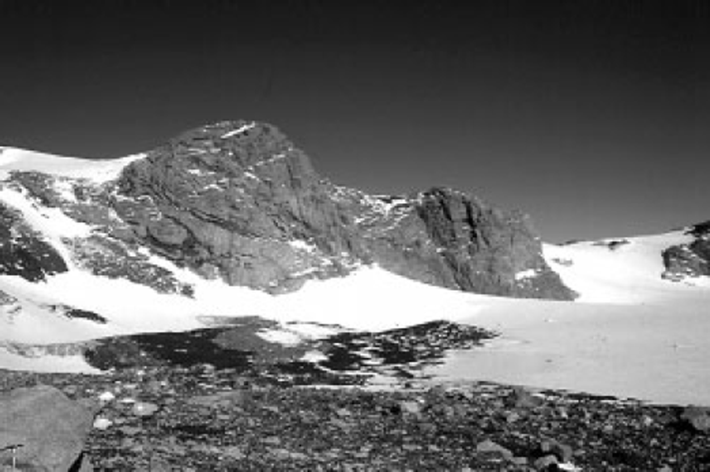
Fig. 5. Holocene ice-cored moraines at the base of the north slope of Section Peak. Dark-coloured volcanic debris and light-coloured granitic debris form parallel bands, suggesting a provenance from progressively exposed bedrock walls of different lithology during Late-glacial and Holocene ice-surface lowering.
Ice-cored moraines are common beside blue-ice glacier margins in the upper Rennick Glacier area and near the margins of outlet glaciers, ice shelves and small local glaciers in the Terra Nova Bay region. They have been attributed to the Holocene on the basis of radiocarbon dates (Reference Denton, Bockheim, Wilson, Schluchter and StumpDenton and others, 1986; Reference Orombelli, Baroni and DentonOrombelli and others, 1990).
A Model of Glacial Reduction
Based on the general morphology and the existence of ice-cored banded moraines, a model is proposed of the glacial reduction since the LGM. Ignoring the problems of the older glacial history related to the upper limit of glaciation (trim-line), the older drifts and the poorly preserved or, locally, perfectly preserved glacial striae, we consider only the glacial changes that have occurred since the Late Wisconsin. The progressive glacial reduction is sketched in Figure 6.
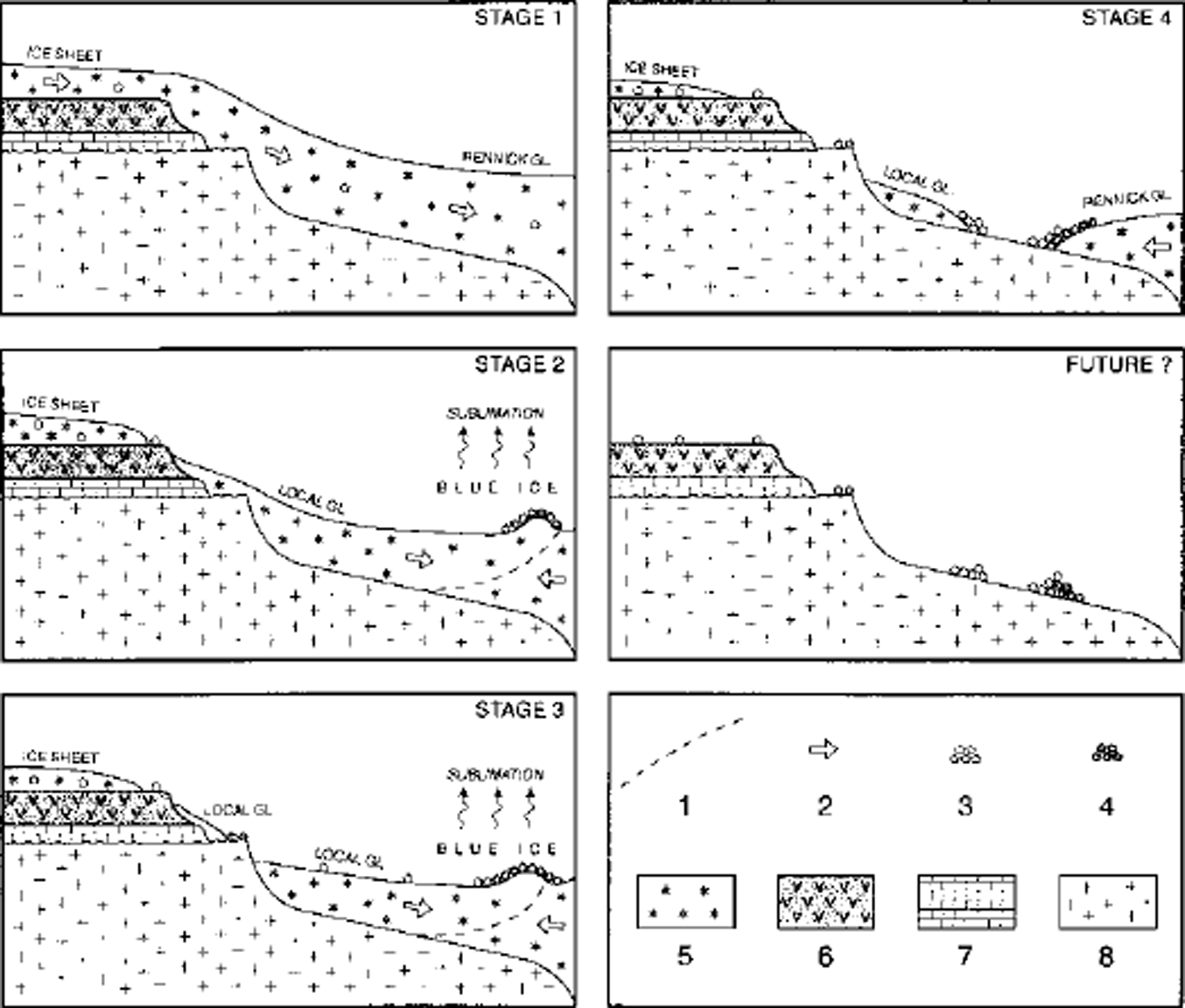
Fig. 6. The proposed model for the glacial reduction since the LGM at the Lichen Hills, leading to the formation of Holocene ice-cored moraines with bands of different rock types. Stage 1 shows the situation during the LGM when the Lichen Hills were covered by ice from the plateau, no blue-ice areas were present and the ice was discharged entirely down-valley. Stages 2 and 3 show the initial phase of glacial reduction with the formation of blue-ice areas, the development of local glaciers still merging into Rennick Glacier and the formation of ice-cored banded moraines. Stage 4 depicts the present situation, with small local glaciers and a blue-ice lobe from Rennick Glacier flowing backward on the lee side of the nunatak. A possible further glacier reduction would lead to the deposition of moraine ridges with bands of different rock types.
Stage 1 shows the situation corresponding to the LGM, with the ice thicker than at present. The presence of slightly weathered granitic erratics on the top surface of the Lichen Hills is evidence of a glacial advance, although we did not find any evidence of a complete overriding of the nunataks. The extent of the glacial advance is difficult to establish, for several reasons: (a) the ice sheet covering the nunataks should have been very poor in sediment load, so it may not have left any erratics; (b) the possible presence of volcanic glacial drift is hard to detect because of the homogeneous lithological composition of the rock; (c) volcanic formations rarely preserve glacial erosional forms, such as striae and roches moutonnees. The presence of fine chiselled rocks along the rim of the top surface reveals a prolonged exposure to weathering. This leads us to believe that these forms were created before the LGM and that during the LGM the Lichen Hills may have been only partially covered by ice from the plateau, with ice-free areas remaining. During the LGM, Rennick Glacier would have been higher than at present and the difference in height between Rennick Glacier and the plateau surface to the west-southwest would have been less. In this situation the turbulence necessary for the creation of blue-ice areas would not have been generated by the katabatic wind, and the ice was entirely discharged down-valley
Stage 2 shows the initial phase of glacial reduction. On top of the higher flat surface, some areas became ice-free and rare erratics were deposited. Glaciers flowing through the summits, or originating from the nunataks, transported downhill mainly volcanic debris falling from the ice-free walls. The increased difference in height between the plateau top and the Rennick Glacier valley resulted in the formation of larger blue-ice areas. In some cases, the ice flowing from local glaciers could have been completely removed by sublimation. In this case, backward-flowing blue-ice lobes from Rennick Glacier with marginal ice-cored moraines developed.
Stage 3 shows a further glacial reduction where a local glacier has divided into two parts: the upper glacier deposited glacial drift composed of volcanic rocks on the exhumed Kukri Peneplain, and the lower glacier generated glacial drift consisting of blocks coming from the exposed walls of granitic and metamorphic rocks. In this way, a new band of the ice-cored moraine formed, which is composed of light-coloured rocks. The disposition of these banded moraines with convexity uphill in some cases, downhill in other cases, was controlled by the interaction between the local glacier and Rennick Glacier, according to the dynamics illustrated by Reference ChinnChinn (1994) for the glaciers of the Convoy Range.
Stage 4 shows a further step in the retreat of the glacier, corresponding to the present. The small upper local glacier on the terrace has disappeared, whilst a gap appears between the lower local glacier, which is forming a frontal moraine composed of granitic drift, and the Rennick Glacier lobe, which has a frontal moraine derived from the ice-cored moraine from stage 3.
A possible future stage showing further glacial reduction could lead to the following situation, from top to bottom (as already partially realised on the slopes west of Lemasters Bluff):
scattered erratics on the summit plateau;
drift of volcanic rocks on the Kukri Peneplain terrace;
moraine ridges, convex in opposing directions, on the lower granitic rocky slope: the most elevated, convex downhill, built up by local glaciers, and the less elevated, convex uphill, deposited by inset tongues of Rennick Glacier due to the katabatic-wind ablation of the base of the rocky slopes (blue-ice areas).
Concluding Remarks
The morphology of the nunataks outcropping in the area of upper Rennick Glacier is strongly controlled by the structure. On the western side, the nunataks have a step-like profile and a tabular aspect, with the top surface corresponding to the volcanic layers. Lower down, terraces correspond to the exhumed surface of the Kukri Peneplain. On the slope of the volcanic rocks, the sandstone layers belonging to the Beacon Supergroup form small walls, and other vertical walls correspond to the Kirkpatrick Basalts, which show typical columnar joints.
The glacial forms are subordinate, with frequent niches resembling glacial cirques, whose origin nevertheless is not necessarily glacial, as suggested by the similar forms of the Dry Valleys (Reference Denton, Sugden, Marchant, Hall and WilchDenton and others, 1993). Roches moutonnees are diffused and well preserved on Granite Harbour Intrusive. During the LGM the ice was at a higher elevation than now. It is likely that some of the top surfaces were ice-free, as delicate weathering forms are locally preserved, which probably required a much longer formation period than the Holocene; these forms would have been destroyed if overridden by the glacier flow.
The presence of glacial drift with different stages of weathering in the northern sector of the Lichen Hills is evidence of repeated fluctuations of the blue-ice lobes produced by Rennick Glacier, with the deposition of a younger drift over an older drift. On the slope to the west of Lemasters Bluff a belt of glacial drift was deposited by a glacial lobe from Rennick Glacier when the glacier was at a higher elevation than now. The presence of such a drift is evidence of the existence of a blue-ice surface similar to the present one. Its elevation (up to about 2100 m) highlights a phase of reduction of Rennick Glacier during the Late Wisconsin to the Holocene, and represents the most elevated record of a blue-ice area in the Lichen Hills.
At the LGM the surface of Rennick Glacier will have been higher than at present, but possibly lower than 2600 m, which is the height of the erratics deposited onto the summit surface of Lichen Hills by the inland ice. Considering the present ice-surface elevation, for there to be at least a partial overriding of the Lichen Hills during the LGM, an increase of about 200 m in the ice surface would have been necessary, while Rennick Glacier in this sector could have been several hundred metres higher than now. This points to larger late Quaternary ice-surface fluctuations in this internal part of northern Victoria Land than previously considered (Reference Orombelli, Baroni and DentonOrombelli and others, 1990; Reference DelisleDelisle, 1993), at least near the nunataks, where reversed slopes of the blue-ice lobes developed.
The presence of banded floating moraines of different lithology is explained by the progressive outcropping, during the lowering of the ice surface, of initially volcanic and later granitic rocks, according to the model shown in Figure 5. The preservation of the ice-cored moraines elongated in bands is linked to the presence of leeward blue-ice areas, affected by intense sublimation. Ablation measurements performed on the Frontier Mountain blue ice show an average value of 0.05 ma−1w.e.
The absence of meteorites in the Lichen Hills blue-ice areas is possibly attributable to the reduction or disappearance of the blue-ice meteorite traps during full glacial times, when all the ice was discharged toward the ocean.
Acknowledgements
This work was carried out within the framework of the Italian Programma Nazionale di Ricerche in Antartide, core project 2a,"Glaciology and Paleoclimate", and was financially supported by Ente per le NuoveTecnologie, l’Energia e lAmbiente through a joint research programme on Antarctic glaciology with the University of Milan.


