

Introduction
The purpose of this chapter is to drill down a level, to illustrate by means of an example some of the detail of the long-term flow structure dynamics that are at work in any interaction that involves humans in profoundly modifying their socioenvironment, with an emphasis on the evolution of information processing. To understand this chapter correctly, it is important to realize that technologies, like institutions and tools for thought and action, are also part of the information-processing apparatus that humans create in their interactions with the outside world. All of these are part of the total knowledge that is acquired in the process, and as such codetermine the path dependency of the processing system. Tools serve to streamline decision-making processes because they mechanize some of the decision-making involved, fixing it in a material substrate that enables certain ways of doing things and constrains others.
Technical systems have a very particular place in our dealings with the environment, and should therefore have a particular position in our research into those dealings. Technical systems do not follow the logic of the societal systems in which they are embedded, nor do they follow the logic of the environmental systems with which they interact. In fact, they have their own logic that will be investigated in Chapters 12 and 13. Moreover, they result in artifacts that are in themselves substantiated tools for specific information processing tasks. As such they are themselves part of the driving dynamics of the evolution of information processing that I summarize in Chapters 8 and 9.
The Pre- and Proto-History of the Rhine Delta
The area presently called Rijnland in the Netherlands is situated just behind the Dutch coastline between two ancient branches of the Rhine, near its mouth. The term is also used for the administrative entity that governs water management in the area. In this chapter, I will try to show that such a conjunction is not accidental.1 Indeed, the management of the environment has not only given rise to new technologies (such as windmills, polders, locks, and dikes), but it has also shaped the institutional development of the Netherlands and many aspects of its societal dynamics. To do so, I will describe the genesis and evolution of the area from around 2000 BCE to the present. In that period, the natural dynamics of the region were completely brought under control of humankind. Tim Ingold (Reference Ingold1987) speaks of “The Appropriation of Nature.”
Like every river, the Rhine has for tens of millennia deposited large amounts of gravel and sand in front of its mouth, in the North Sea. As the sea level rose under the impact of non-anthropogenic climate change, and the deposits built up simultaneously, the river’s flow slowed down and the difference in level between water and land diminished, until in many places it was only a few feet. A true delta emerged, in which the sea and the river continually struggled for dominance. Sometimes above and sometimes underwater, the natural levees (ridges) became areas on which vegetation took root. But as long as the sea regularly inundated them during winter storms, and deposited large amounts of sand on the levees, vegetation could not really establish itself.
Around 2000 BCE, currents in the North Sea shifted and caused the slow buildup of a row of levees that protected the area immediately behind it from the sea (van der Leeuw, Reference van der Leeuw and Manzanilla1987; Brandt & van der Leeuw Reference Brandt, van der Leeuw and Purdy1988). The largest mouth of the Rhine shifted toward the north, fresh water accumulated behind the levees further south, and as the vegetation flourished in this area, which was now protected from the sea, it became a peat marsh.
Eventually, people settled in that marsh, initially on small tufts of peat that were a little higher than the surrounding landscape and on the edges of the creeks that drained it. These early settlements consisted of a very small number of houses (generally one to four). People exploited the land by planting some cereals and other edible plants and by allowing some domesticated cattle and sheep to graze there (Brandt et al. Reference Brandt, van Wijngaarden-Bakker and van der Leeuw1984). But the battle against water dominated their lives. One finds drainage ditches around the individual houses, and with time individual houses were built on small artificial mounds (terpen in Dutch) to ensure that they were not inundated in periods of high water when storms or high tides in the North Sea blocked the Rhine’s mouth and fresh water accumulated behind the dunes (Brandt et al. Reference Brandt, Groenman-van Waateringe and van der Leeuw1987).
To cultivate their crops, people also had to drain the peat. But as soon as the water table was lowered, the (drying) peat either oxidized or blew away, lowering the level of the land. This engendered a positive feedback loop that made drainage more and more difficult, and heightened the danger of inundations. The drainage ditches grew longer and longer, eventually creating a complicated network. These longer ditches are the first sign that people began to collaborate and organize themselves in the battle against the water.
By about 900 CE, the inhabitants’ strategy in dealing with the water changed – rather than building individual mounds for themselves, they began to collaborate in enclosing certain (initially small) surfaces by means of artificial defense systems (dikes, dijken in Dutch, levees in US English) several meters high. We may interpret this as a sign that local societal organization had reached a new level.
The Middle Ages: Keeping the Land Dry Leads to the Hoogheemraadschap Rijnland
Around 1000 CE, another factor came into effect: the political organization of the area (see van Tielhof & van Dam, Reference van Tielhof and van Dam2006, the most recent authoritative work on the history of Rijnland, upon which I have heavily relied for this chapter, including for the illustrations). Feudal lords began to play a role in the western part of what is now the Netherlands. An endless series of skirmishes between small local potentates ultimately created a political hierarchy. Not surprisingly, this process was somewhat more advanced in the drier parts of the delta than in the wetter areas nearest the coast. In particular, the bishopric of Utrecht, situated on higher ground (the sandy moraines left by the last Ice Age), had a longer history as a political entity than the lower areas immediately behind the dunes, collectively called Holtland (the woodland, from which the current Holland derives). Holland and Utrecht remained politically distinct for most of the Middle Ages, and there was a continuous series of political and military conflicts between their official rulers, the Counts of Holland and the Bishops of Utrecht, as well as among their feudal dependents.
During this time, Holland was administratively divided into several entities (so-called baljuwschappen), of which two are particularly important for this story: Rijnland, with Leiden at its center, and Kennemerland, with Haarlem as its focus (Figure 10.1). Both their centers were located at the easternmost edge of the natural levees that protected the landscape from the sea and were therefore themselves relatively safe from inundation.
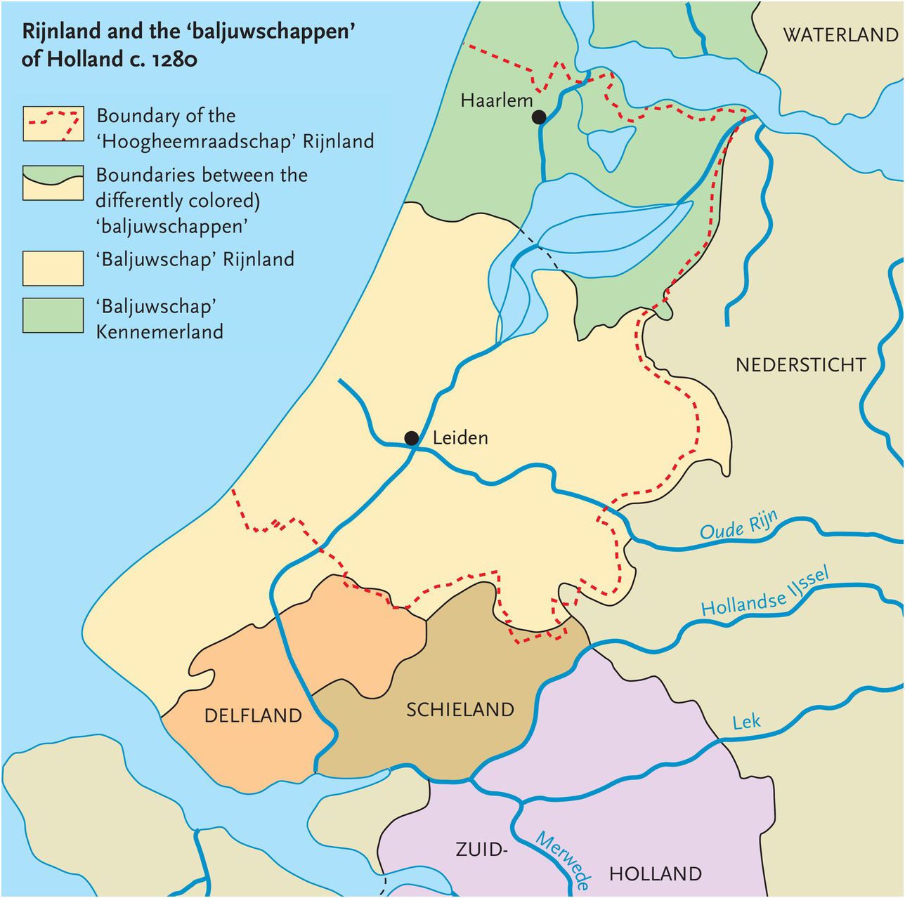
Figure 10.1 Administrative units in western Holland, c. 1280. Kennemerland and Rijnland were later brought under the authority of the Hoogheemraadschap Rijnland for all matters concerning water.
Around 1150, the mouth of the (Old) Rhine to the west of Leiden was definitively closed by the movement of large amounts of sand in the northward current along the coast. This caused the area behind the dunes to suffer more frequently from river inundation, and by 1280 collective action had to be taken on a larger scale. Not surprisingly, the first major collective intervention – the damming of the Rhine upstream to protect the inhabitants of Rijnland from flooding by the river – occurred at the boundary between Utrecht and Holland. Canals were then dug from Leiden to the north and the south, to ensure that the area’s surface water could be evacuated without danger to the population of Rijnland. But canals have the unfortunate property that they can, if the water level inverts, also be sources of flooding. Hence, locks had to be constructed at the mouth of both canals (see Figure 10.2).
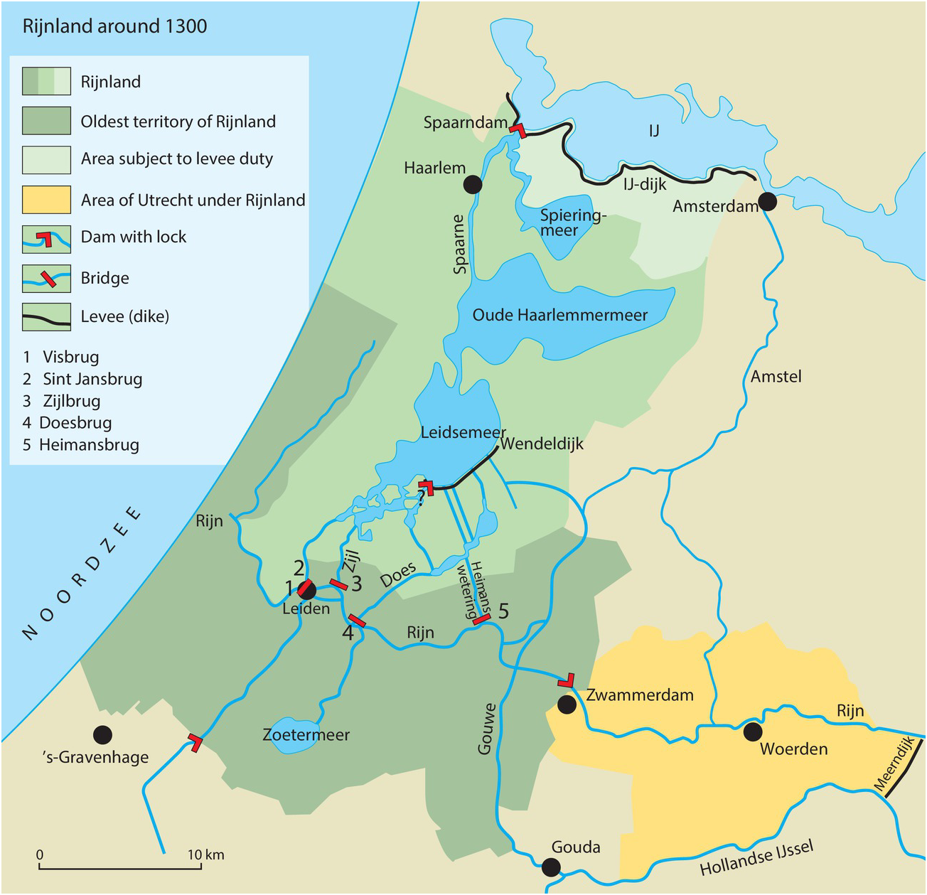
Figure 10.2 The situation in around 1300. Rijnland is in diverse shades of green. Note the civil engineering works (dikes, locks, dams) containing and guiding the water of the Rhine to the north and south of the area.
Notwithstanding these efforts, Rijnland remained very vulnerable to flooding, especially from the two large lakes (Leidse Meer and Haarlemmermeer) to the north of Leiden. It quickly became clear that to protect Rijnland from this danger, cooperation was necessary with the terrestrial authorities of Kennemerland, to the north of Rijnland, so that a dam and a sluice could be built at the hydrologically most propitious location; along the edge of the open mouth of the Rhine to the north of Haarlem. This cooperation is the first tangible sign that water management has its own rules and its own geography, which do not necessarily follow those of politics or administration. One cannot safeguard against flooding if there is no unified management. The risk is so great that differences of opinion lead to disaster. Hence, for the purposes of water management, and water management only, the southern part of Kennemerland soon became part of Rijnland. A typically Dutch solution was found: to create a dedicated “water authority,” the Hoogheemraadschap, which could impose its power on all the other political and administrative authorities within its territory, including the highest, but only in so far as water issues were concerned. From this point forward, there were two Rijnlands, that of the baljuw (the highest civil administrator representing the count), and that of the dijkgraaf (not accidentally called the “count of the dijken.” (The territory of the latter (marked by a dotted line in Figure 10.1) exceeded that of the former.)
The Early Modern Period: Land Is Turned into Water
When drained, peat is incredibly fertile, as it consists entirely of decaying or decayed organic matter. Once the medieval water problems at the regional scale had been solved, therefore, the area very quickly became a rich and intensively cultivated agricultural zone. But maintaining the agricultural intensity depended on the ability to continually drain the land. Between plots of cultivated land, narrow ditches (sloten) were dug to drain them. These drainage ditches ended at larger artificial or natural waterways, evacuating excess water to the main streams or canals crossing the territory of Rijnland.
As a result of the shrinking of the peat inherent in this loss of water and the oxidation of the organic material due to the intensive cultivation, the surface of the peat descended about 1 m per century, coming closer and closer to the subsurface water table. Because the land became wetter, its fertility declined, as did the yields of the farmers cultivating it. A process was set in motion that ultimately resulted in the surface of the land descending below that of the water. Urgent solutions were needed, again requiring major investments.
As a consequence, levees were built on both sides of the draining waterways to prevent the land from flooding. But to remove excess water, it now had to be moved up and away, instead of downward. To solve that problem, horse- or wind-driven watermills were introduced in 1408, which pumped the water up from the drainage ditches into the major waterways. As a result, a huge number of windmills dotted the landscape.
The lowering of the land surface with respect to the water table also changed the economy of the area. The local reduction in the cereal yield occurred at a time when, around the Baltic, grain was cheap and easy to obtain. This stimulated trade in the small towns, which until then had heavily relied on fisheries. Hence, it became more attractive to let the land (now often soggy) revert to pasture for grazing cattle and sheep. Milk and butter, as well as meat, fetched good prices in the growing towns of the area, and required much less labor than cereal cultivation. In turn, this forced many marginal farmers to find other means of subsistence. Some adopted other rural professions, such as fishing, but many of them moved to the towns, where there was demand for cheap labor in such typical urban activities as trade and industry. Others manned the ships that enabled a substantive growth of commerce from the cities.
The fourteenth to sixteenth centuries saw a very important expansion of urbanization in the area, under the impact of rapidly growing long distance trade and the industrial production of trade goods. Continued misery in rural areas maintained the influx of poor peasants into the cities and kept the price of labor low, thus stimulating shipbuilding and other crafts and industries. which, in turn, drove the rapid urban growth. In particular, the Dutch coastal towns of the thirteenth century became involved in trade between the Baltic countries, Great Britain, and the Atlantic coast of France. They brought dried fish, pelts, and other Nordic items to Britain and France, exported British wool to Flanders, and Flemish (woolen) cloth to France and the Baltic, as well as transporting wine from the Garonne area in Aquitaine to both Britain and the Baltic. As that trade intensified, the Dutch coastal towns of Leiden, Haarlem, and especially Amsterdam grew rapidly and increased the production of their own trade goods.
The industries that thus emerged needed fuel, and by this point most of the original Holtland had little forest left. Indeed, the only locally plentiful fuel was the (dried) peat that was sold in the form of turves for heating and industrial production, such as pottery-making. Consequently, the price of turves increased drastically, and more and more farmers reverted to digging away their land and selling it as fuel. Relatively quickly, this created surfaces of open water, which, in turn, became a danger to the remaining land by undermining its stability and subjecting it to flooding in stormy weather (Figure 10.3).
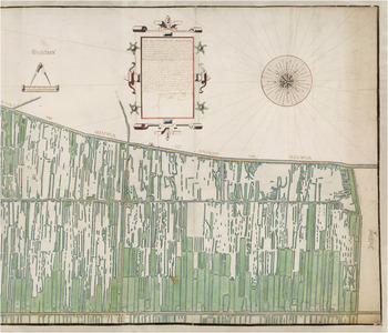
Figure 10.3 Detail of a map of a peat exploitation area in the Zegwaard. Author and date unknown. The map shows how the land surface is exploited, and how in certain areas, larger surfaces of water are emerging.
In the last phase of the early modern period, major collective activities dealing with aspects of water management were made possible by concerned volunteerism, which was subsequently replaced by wage labor paid for by a land tax imposed by the authorities of what was now the Hoogheemraadschap Rijnland.
As land was progressively dug away, of course, this reduced the tax revenue necessary for the maintenance of the dams, canals, and locks that kept the water under control. Hence, the water authorities tried to limit peat extraction and increase their taxation-based income by forcing those who practiced it to buy other tax-liable land, to compensate for the loss of income when land was dug away to become water. In the process, the water authorities gained control over aspects of land management.
This became all the more urgent because the increase in open water required another reorganization of water management. Improved locks were installed along the northern edge of Rijnland, which opened to drain the land during ebb and closed to protect the land at high tide (Figure 10.4). To realize these improvements, the Hoogheemraadschap extended its control to all the dams and related engineering works in the area.
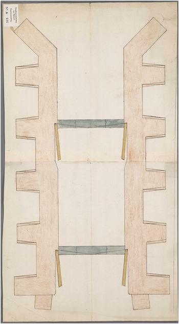
Figure 10.4 Top view of the Western lock in the Spaarndammerdijk at Halfweg by Cornelis Cornelis Frederixzoon (1556). The area to be drained is to the north of the lock (top of the illustration). When it is low tide to the south, the lock opens automatically and allows the water to flow out of the drained area. At high tide, the lock closes automatically, preventing water from flowing in.
The ‘Golden Era’: Water Is Again Transformed into Land
In the Netherlands, the period 1550–1650 is commonly called the Golden Century. It is the era in which the Dutch gained their freedom from Spain through a war that lasted eighty years (1568–1648), while the Dutch merchant fleet vied with the British for control of the oceans and Dutch merchants, particularly from the western part of the country (Holland and Zeeland), founded trading posts and colonies around the world (Dutch East Indies, Southern Africa, Brazil, Eastern North America, etc.). The Dutch coastal cities grew exponentially, and Amsterdam became one of the capitals of the world. Many urbanites profited from the rural poverty by purchasing tracts of agricultural land, grassland, or peat. From this point onwards, the towns had a direct economic interest in the countryside, and they vied with the Hoogheemraadschap for control over it. In the meantime, the Hoogheemraadschap itself ran into financial problems. An agrarian crisis in the first half of the seventeenth century occurred in parallel with a decline in available peat. As peat became the dominant source of income, the next predictable step was to impose a tax on peat rather than on land. Rising urban wealth and the need to feed a rapidly growing urban population in the seventeenth century led to a rapid increase in grain prices in the 1660s, again tipping the balance between agriculture and stockraising. For a period of some thirty years, agriculture once again became profitable. Hence, some of the (artificial) lakes in Rijnland and other parts of Holland were pumped dry, by first digging a canal around them and then installing at their edges batteries of windmills, each of which lifted the water a little higher until it could eventually be dumped into the canal surrounding the drained area (Figures 10.5a, b). After such an area had been laid dry, drainage ditches were dug across it in a rectangular pattern to ensure the maintenance of a low water table. The fertile clays thus laid bare were quickly turned into rich cereal fields.
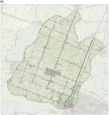
Figure 10.5a Topographic map of the Beemster polder in the Netherlands in 2015. One clearly sees the canal surrounding the polder, which served to drain it (and now keeps it dry), and the rectangular spatial organization of ditches that connect to the surrounding canal. At the time of drainage, the water was removed by windmills, as in Figure 10.5b; now it is removed by modern pumps.
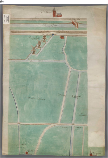
Figure 10.5b Set of three windmills near Reeuwijk. Author and date unknown. Three windmills are required to pump the water from the polder into the drainage canal surrounding it.
The investment needed to do all this, however, was beyond the means of what remained of the impoverished rural population, nor could it be funded by the Hoogheemraadschap as long as its principal source of income was the peat tax. Private investment by rich urban shareholders, associated for this purpose in ad hoc partnerships, took over the financial burden, enabling urban control over rural land.
In 1675, just after a major war (1672–1674) between the Netherlands (or more specifically Holland) on the one hand, and Britain, France, and two German principalities on the other, the main dam protecting the Rijnland against flooding broke on two occasions. Similar events occurred again in the following century. Delayed maintenance may well have been a factor because the Hoogheemraadschap was no longer solvent.
The disaster of 1675 was of such proportions that the towns (led by Amsterdam, Haarlem, and Leiden) loaned the Hoogheemraadschap the necessary funds for repairs and improvements. Subsequently, the Hoogheemraadschap began raising funds for maintenance and investment by issuing bonds against future revenue from the peat tax.
The cities’ inhabitants, many of which already owned land in Rijnland, subscribed to most of these bonds. The loans set in motion a process whereby the cities and their inhabitants ultimately established control over the Hoogheemraadschap and the rural environment that surrounded them.
Regaining Lost Ground
After about 1700, agriculture did not return to profit in a major way until the second half of the eighteenth century. At the same time, underwater peat exploitation neared the limits of what was feasible with the technical means available at the time. Income from peat (and the peat tax) declined, while protecting the banks of the lakes became an increasingly urgent and costly affair. Inhabitants and authorities were therefore faced with the question of whether it was worthwhile to continue exploitation of the area.
Deserting it would have led to major inundations and other problems. The solution chosen was to further transform water into land. The few attempts at draining small man-made lakes in the seventeenth century had demonstrated that the rich soils at the bottom could be profitably used to produce grain, meat, milk, and milk products. Hence, Rijnland and other authorities devised schemes to fund the drainage and reclamation of many of the lakes, borrowing money against future tax freedom or investing some of their own funds. The positive results of this venture initiated a phase of major land reclamation focused on lakes of limited depth and size all across Rijnland and, in effect, all over Holland.
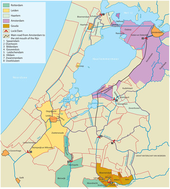
Figure 10.6 Owing to the insolvency of the Hoogheemraadschap it could not repair the dams; the cities Haarlem, Leiden, and Amsterdam took control over the whole area.
During the eighteenth century, plans to drain the (huge) Haarlemmermeer were considered several times. This large surface of open water was an important part of the transportation network, yet its size and shallow depth made it very dangerous to shipping whenever there were high winds or storms, and its edges were regularly inundated. In particular, with strong western winds, its eastern edge became a real cemetery for ships (Figure 10.7); hence the name for Amsterdam’s airport, Schiphol, which literally means “hell for ships.” But the huge costs involved could not be borne by the Hoogheemraadschap or other local or regional authorities, in part because the eighteenth century was a much less wealthy time for the Netherlands than the preceding one. Time and again, the plans were postponed.
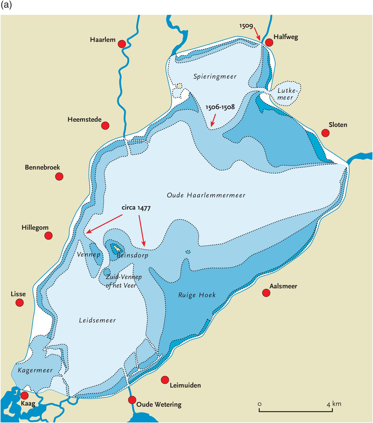
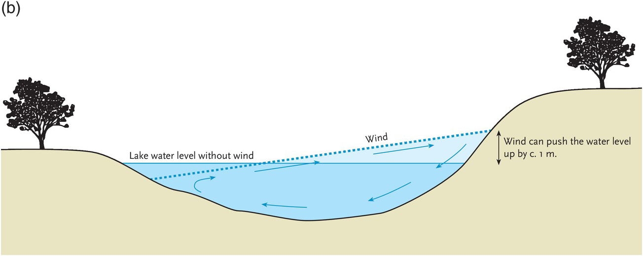
Figure 10.7 Peat excavation weakened the edges of the lake, and open water caused wind and water to batter them (Figure 10.7a). The lake doubled in size between 1250 and 1848, and with a strong wind from one direction the water level on the opposite shore could be driven up a meter or so, inundating the land(Figure 10.7b).
After the French occupation of 1795–1814, the federation of provinces that constituted the Republic of the Seven United Netherlands (Republiek der Zeven Verenigde Nederlanden) was replaced by a kingdom that included Holland, Zeeland, and the five other provinces. Simultaneously, in the East Indies, a novel landholding and exploitation system (in the form of plantations) substantively increased the income of the nation and the state. The state now had the resources needed for the project, and the invention of steam engines to drive the pumps made draining the Haarlemmermeer technically feasible.
But it was not until a furious hurricane in November 1836 drove the waters as far as the gates of Amsterdam, and another on Christmas Day the same year that sent waves in the opposite direction to submerge the streets of Leiden, that the mind of the nation seriously turned to the matter. On August 1, 1837, King William I appointed a royal commission of inquiry, and in the following May the work began. A canal of 61 km was dug around the lake, fittingly called Ringvaart (Ring Canal), to enable water drainage and boat traffic that had previously gone across the lake. The dug-out earth was used to build a dike between 30 and 50 m wide around the lake. The area enclosed was more than 180 km² and the average depth of the lake was 4 m.
As the area had no natural drainage, around 800 million tons of water had to be pumped into the Ringvaart by mechanical means to transform it into land. Unlike the historic practice to drain polders using windmills, steam powered pumping stations were used, a first. Three steam pumps were built: the Leeghwater, the Cruquius, and the Lijnden.
Pumping began in 1848, and the lake was dry by July 1, 1852. Rather than being incorporated into any particular existing administrative organization, it was given the status of an independent municipality within the province of Noord-Holland. The state thus directly assumed control over the newly reclaimed territory.
With the reclamation of the Haarlemmermeer, the history of water and land in Rijnland comes to a provisional end, as no major reversals or new reclamations have subsequently occurred in the area.
The Aftermath
But elsewhere in the Netherlands, well into the twentieth century, this project was followed by other, increasingly ambitious, ones. Initially, these reclamation projects were concerned with large parts of the so-called Zuiderzee, the large open water in the center of the country. In 1929, it was closed off from open sea by a dam connecting the provinces of Noord-Holland and Friesland. Draining the first of the polders in what was now called the IJsselmeer (ex-Zuiderzee), the Wieringermeerpolder, was completed in 1930. During World War II, this was followed by completion of the Noord-Oost Polder (1942). After the war, two huge new polders were also reclaimed, respectively called Oost Flevoland and Zuid Flevoland. In total, 1650 km2 of land were reclaimed in the 1950s to 1980s).
A last major flood occurred in 1953 when large parts of Zeeland and Brabant were inundated by a combination of an extremely high tide and a strong westerly storm. This came at a time when the dams protecting these areas had been weakened by lack of maintenance during World War II and its aftermath.
It led to a major project (the so-called Delta-werken) that now protects the area, but the idea to reclaim more land was abandoned when the Netherlands opened its trade borders more and more to agricultural products from elsewhere in Europe in the context of the emergence of the European Union (EU) (Figure 10.8).
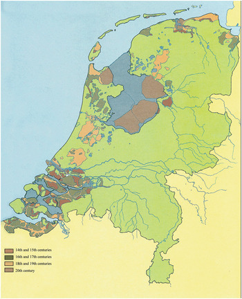
Figure 10.8 Overview of the areas of the Netherlands that were artificially drained in various periods of the country’s history.
Both in the case of the reclamation projects in the IJsselmeer and in that of the Delta-werken, only the national government had the means to undertake them, and it therefore exerted its authority over them. In effect, from its first emergence out of the sea until 1986, the whole of Flevoland and its inhabitants was subjected to the authority of a single person appointed by the government, the Landdrost!
Summary and Conclusion
The outline of the story recounted here is well known; the western Netherlands were created, as well as peopled, by its inhabitants. Water was initially a threat from which to flee and then something to be contained. The point is that not only the land itself, but new technologies, institutions, a new spatial organization, and much of Dutch culture emerged from the interaction between people and water.
The need for drainage and containment first led people to collaborate and to develop new techniques to deal with the dangers of both short-term floods and long-term degradation of terrestrial resources. The dynamics coupling environmental limitations and social initiatives resulted in newly invented management techniques that addressed and frequently solved differences of opinion and created powerful institutions. Thus, the first supraregional authority, the Hoogheemraadschap, under its president, the dijkgraaf, was created in response to the water management issue – an issue that could not be left in the hands of much smaller political principalities.
In the struggle, water was transformed into land for cultivation and grazing, and this land was then transformed into lakes by selling it in the form of turves to fuel hearths and industries. Ultimately, these lakes were drained to recreate agricultural land when the need was felt.
As a result, the surfaces of large parts of the western Netherlands were lowered to between 1 and 6 m below sea level, creating a situation of extreme vulnerability to any sea level rise that might be caused by climate change.
One of the important lessons of this story is that a kind of cyclical “Tragedy of the Commons” is taking place. It evidences the ongoing battle between individuals, institutions creating opportunities for individuals by containing the water, individuals creating new water-related threats, the calls for strengthened institutions, etc.
Individuals first colonized these low-lying parts of the delta. As they drained it for cultivation, or to build small artificial mounds to keep their houses and animals dry during floods, other longer-term threats emerged that could not be dealt with individually. Large-scale drainage systems were dug, and instead of building individual artificial mounds, people began collectively to protect land against floods by building dikes. In the process, they created institutions such as the Hoogheemraadschap to guard their collective interests. Once that was done, and cultivation enabled people to make a good living, land degraded and the economy arose and the economy shifted to grazing. Grazing is less demanding of the land and the drainage infrastructure than agriculture. When land became unsuitable for even that form of exploitation, the same individual interests transformed land into fuel. Thus, it created open water and undermined collective safety as well as the institutions that had been put in place to protect against the water.
From another perspective, it is all about spatial and temporal scales. Ultimately, when water became a local and regional threat once more, and there was insufficient land to provide food, the tendency was inverted by non-rural individuals who saw the benefit in, and provided the means to, collectively transform water into land. These means were derived from activities elsewhere, first in different urban sectors of the regional economy (successively fishing, regional trade, industry, and banking) and later on the high seas (long-distance trade and piracy), or, after 1815, in the Dutch colonies. In the process, the area became increasingly dependent on other parts of the world, other resources, or other feedback cycles (the spatial scale of the system was stepped up each time a disaster threatened or hit). Thus, the reclamation of the Haarlemmermeer was funded in part by the increasing stream of riches gained in the Dutch East Indies, where a system of intensive plantation agriculture for the European market had been instituted. In turn, the reclamation of Flevoland was made possible by the economic boom after World War II, to which the birth and growth of the EU was also closely related. In the end, the integration of the EU made further drainage uneconomic because the agricultural products that could be grown there were now made available more cheaply elsewhere.
As long as the local and regional cyclical lows did not coincide, the highly artificial and very costly system could be maintained. Local profits could be made thanks to investment of funds gained elsewhere. In Rijnland this was the case when either urbanites or the cities as institutions collectively intervened to fund the protection of land against water. Nevertheless, if there was a temporal overlap between lows in both regional and more global cycles, problems hit with redoubled severity, such as in the eighteenth and the first half of the nineteenth century. Then, disaster could only be averted by yet another increase in the spatial and the temporal scale of the system. For example, by invoking the help of the national government to drain the Haarlemmermeer, the frequency with which problems hit was dramatically reduced and both the material and institutional infrastructure that maintained the polder in a steady state was strengthened. In the process, the scope and scale of threats and institutions bootstrapped themselves to eventually encompass all of the Low Countries, shaping much of Dutch society to this day.
The story beautifully illustrates the role of risk perception in generating unintended consequences in environmental management by society. In attempts to deal with frequently occurring events in the interaction between people and their environment (such as the seasonal inundations that led people to invent artificial mounds), human intervention leads to new perspectives and new actions (such as the enclosing of whole areas by artificial levees). However, these changes frequently engendered new risks, of which neither the nature nor the frequency was known. When these risks materialized (in the form of decadal or even centennial floods, for example), other means were sought to deal with them, and the changes wrought in the environment introduced yet more risks – again of unknown nature and frequency. The investment to maintain these solutions could prove too costly for the local population, resulting in the additional risk of an area becoming dependent on another region’s economic cycles.
In each instance, the solution to an imminent challenge was based on interventions in the environment that triggered other challenges, both environmental and societal, down the line. The latter were less frequent and involved a larger timescale. As a result, over time the risk spectrum shifted from relatively frequent, spatially limited risks to less frequent but more consequential risks. Ultimately, the accumulation of risks with unknown, longer, temporalities led to another set of risks that could burst upon the scene simultaneously: a time-bomb or crisis, such as the current environmental crisis.
A conceptually similar story, about the emergence of modern finance and long distance trade in Renaissance Florence, has been elaborated by Padgett and others in great detail (Padgett & Ansell Reference Padgett and Ansell1993; McLean & Padgett, 1977; Padgett Reference Padgett, Arthur, Durlauf and Lane1997, Reference Padgett, Casella and Rauch2000; Padgett & Powell Reference Padgett and Powell2012), based on the analysis of 50,000 lives of Florentines in that period. It shows wonderfully how social relations, initially around city squares and plazas, led to financial exchanges, the availability of more capital, the need for better accounting (leading to double-entry bookkeeping), longer and longer distance trade, and many other aspects of both financial and power relations. It also shows the power of the complex systems approach in promoting understanding of societal dynamics.
In addition, as part of the ARCHAEOMEDES project, Christina Aschan-Leygonie did an interesting and related study on why, in the Haut Comtat in France, a crisis in the 1860s was quickly resolved and another one, a century later, was not (van der Leeuw & Aschan-Leygonie, Reference van der Leeuw, Aschan-Leygonie, Svedin and Lilienstrom2005). I refer to this in Chapter 6.
Although the exact nature of the changes that emerge in the process of innovation may be unanticipated, the fact that changes will emerge is far from unexpected. Similar situations and chains of events have occurred whenever and wherever people tried to impose particular solutions to the challenges posed by the environment. They seem profoundly inherent in human interactions with the environment, as those interactions are often based on making a distinction between us and our environment, although that environment is not ours to possess or on which to impose our solutions. In the current extreme form, that is a particularity of western culture that has become more and more prevalent since the fourteenth century, as outlined in Chapter 3.
Maybe we should take a closer look at the worldview of such societies as the Achuar, who do not make such a Manichaean distinction between themselves and their environment (Descola, Reference Descola2005), and from that starting point attempt to reconstruct how our present worldview might have evolved from a position like theirs. To conclude, let us therefore spend a little time looking at how we might indeed change our perspective so as to get a better grip on these dynamics.
First of all, and inherent in the Complex Adaptive Systems perspective, the point of view that we choose should be an ex-ante perspective rather than the much more common ex-post perspective. To understand new phenomena, we should be following the process of their emergence, rather than studying the origins of the current situation. We should develop a perspective that goes with the arrow of time, rather than against it. A necessary corollary of that position is that our approach should not reduce the number of dimensions taken into account in order to generate understanding (as much of science still does), but should enhance the number of dimensions taken into account. While studying to learn from the past, we should do this in order to learn for the future. This advocates for methodologies that inherently increase uncertainty and require us to embrace it, a reframing of uncertainty as positive and an advance. Needless to say, in practice, both in the academic domain and in the world of application, one encounters enormous resistance to this idea.
Part of this is the fact that we must move away from using one or a few causal chains to explain the present, and in general start thinking in multiple alternative scenarios (Bai et al. Reference Bai, van der Leeuw, O’Brien, Berkhout, Biermann, Broadgate, Brondizio, Cudennec, Dearing, Duraiappah, Glaser, Revkin, Steffen and Syvitski2015). By evaluating these, and in particular by comparing the unintended consequences of the choices made (by individuals or systems) with those that would have occurred had another option been chosen, we will get a much better grip on the relationship between choices and unintended consequences, and thus reduce (unperceived) risks as we move into the future.
Crucial in all this is the fact that we have not been able to do all this until now – indeed, our centuries-long intellectual tradition, the inherent limitations to our information processing, as well as other factors militate against such an approach. But with the information age, a number of barriers may be about to be taken away, or at least reduced. For one, modern terabyte data-dense monitoring may overcome, at least to some extent, the under-determination of our ideas by our observations. Secondly by (much) more closely integrating computing into our societal information processing than has been done to date, we may be able to take into account many more dimensions of the phenomena and processes we deal with in our decision-making. But for that to happen, we must begin to harness computing in a different way, emphasizing our capability to move from lower to higher dimensionality as well as in the other direction (as we do now). This amounts to creating the tools to move from the past to the future as well as in the reverse direction. Essential in developing this capability is the need to use much more extensive modeling, and in particular agent-based modeling to enable us to understand how an ensemble of individual actions creates collective patterns and processes (van der Leeuw et al. Reference van der Leeuw, Costanza, Aulenbach, Brewer, Burek, Cornell, Crumley, Dearing, Downy, Graumlich, Hegmon, Heckbert, Hibbard, Jackson, Kubiszewski, Sinclair, Sörlin and Steffen2011). If we are able to achieve that at least to some extent, it may help quell fears about increasing uncertainty. If you know with certainty that you have to navigate through a hundred different uncertain possible outcomes, this is better than not knowing the scale of uncertainty in your future, and this is especially relevant if you are transitioning from the comfort of an illusory belief that there are just three or four possible outcomes.


 Open access