


Introduction
During the late first millennium BC and early first millennium AD, the foothills and mountains of the north-central Zagros constituted an internal hinterland of the Parthian Empire. This region was marked by distinct cultural and political characteristics—in many respects determined by its geography—and bounded by the Mesopotamian Plain in the west and the Iranian Plateau to the east.
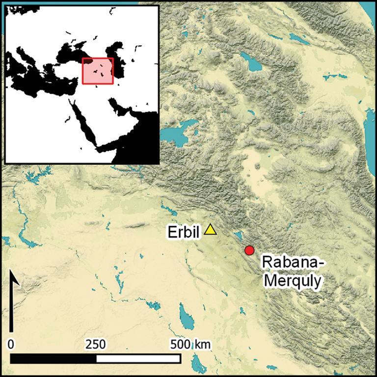
The fortress of Rabana-Merquly is located on the south-western flanks of Mount Piramagrun, near the village of Qarachatan in the Zagros Mountains in Iraqi Kurdistan (Figure 1A). The site overlooks the floodplain of the river Charmaga, a major left-bank tributary of the Lower Zab (ancient Kapros). The construction of the perimeter fortifications took advantage of the rugged highland terrain to encircle two neighbouring settlements, one in the Rabana Valley and the other on the Merquly Plateau (Figure 1B). Despite the impressive scale of construction, Parthian-era occupation of Rabana-Merquly appears to have been relatively short-lived; the main architectural phase is tentatively dated to the first century BC, with parts of the complex showing evidence of reoccupation during Sasanian, Islamic and modern times.
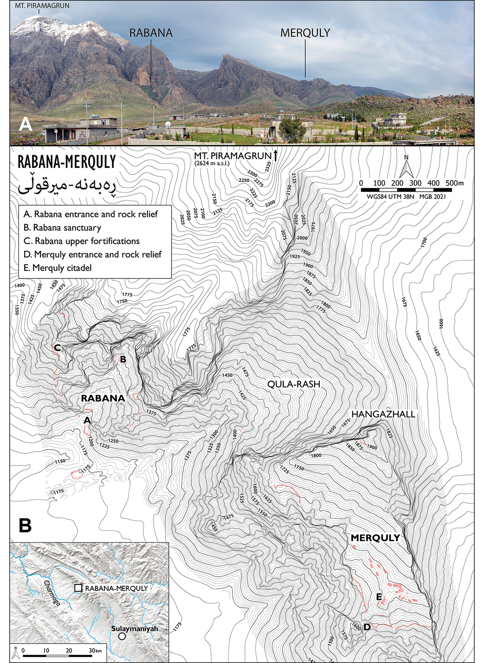
Figure 1. A) Mount Piramagrun, showing the location of the main Rabana and Merquly settlements; B) general plan of Rabana-Merquly (map by M. Brown; © Rabana-Merquly Archaeological Project).
A defining feature of Rabana-Merquly is the two rock-reliefs carved into the cliff-face adjacent to, and plausibly associated with, two gated entrances, depicting an unnamed ruler in ornate attire (see below). While the identity of this individual is a matter of conjecture, Rabana-Merquly would have been close to the south-eastern frontier of the vassal kingdom of Adiabene, within the dominion of the Parthian (or Arsacid) Empire. Although the Parthian conquest of Adiabene is not explicitly recorded in ancient texts, it is known to have been under Arsacid control from the time of Mithridates II (r. 124/123–88/87 BC) (Marciak Reference Marciak2017: 346–47).
Our knowledge of Parthian archaeology and history remains markedly incomplete, despite its evident significance as a major power in the ancient Near East. The following article presents new information about the important regional centre of Rabana-Merquly and examines its role in the landscape of the north-central Zagros and the broader framework of the Parthian Empire. Furthermore, we combine archaeological data with numismatic and textual sources to identify the potential ancient name of this site. By highlighting clear examples of political and military agency, this article aims to challenge the prevailing notion of an inherently weak Parthian state.
The north-central Zagros highlands during the Parthian period
Rabana-Merquly is one of a handful of large, fortified centres in the north-central Zagros (Figure 2) that dominated settlement hierarchies during the Parthian period. The most closely comparable site is Qalʾeh-i Yazdigird, located on the opposite side of the Zagros Mountains in western Iran; it similarly comprises a large enclosure, within which a dispersed array of structures served a variety of defensive, political and sacred purposes (Keall Reference Keall1982). Like Rabana-Merquly, the position of Qalʾeh-i Yazdigird and that of the fortified settlements of Amadiya (Miglus et al. Reference Miglus, Brown and Aguilar2018; Bahrani et al. Reference Bahrani2019) and Qalatga Darband (MacGinnis et al. Reference MacGinnis2020) in Iraqi Kurdistan reflects a desire by their local vassal rulers to control strategic overland communications.
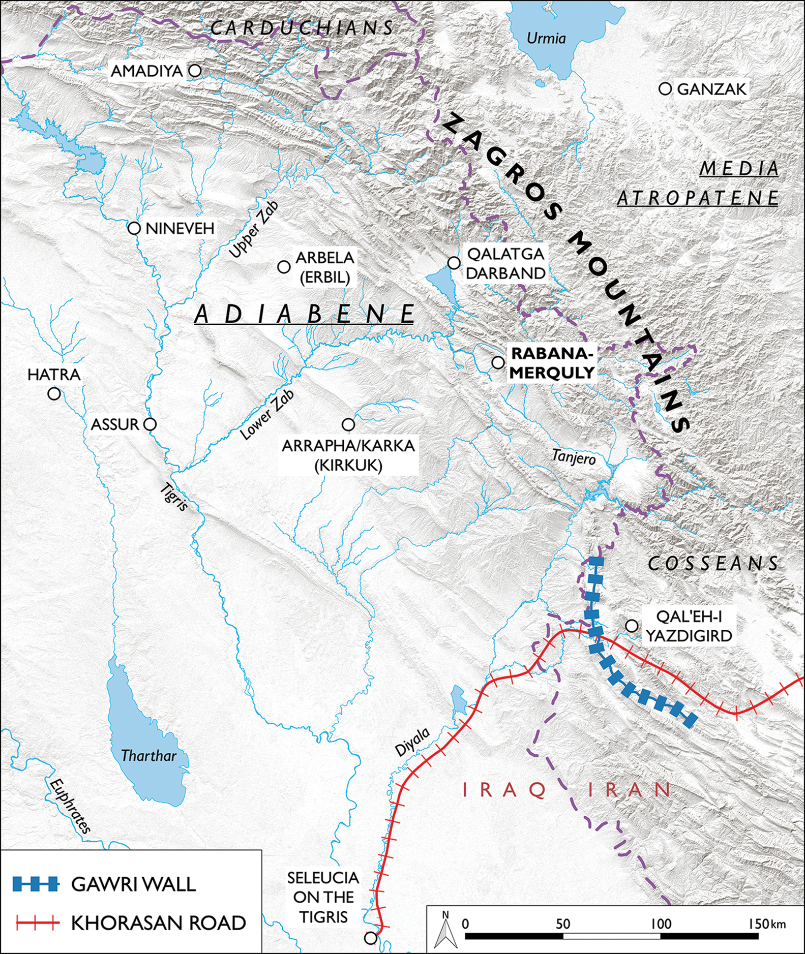
Figure 2. Map of the north-central Zagros region with sites and features mentioned in the text (map by M. Brown; © Rabana-Merquly Archaeological Project).
Several extensive stretches of extramural fortification wall in the region can also potentially be associated with Parthian-era fortified settlements. The longest of these linear barriers is the Gawri Wall, which extends some 115km through Sarpol-e Zahab County in Kermanshah Province, Iran (Alibaigi Reference Alibaigi2019). This massive barrier complements the natural topography, forming a continuous line along the Zagros range; the ceramic finds associated with it suggest that it was, in part or wholly, a Partho-Sasanian construction (Alibaigi Reference Alibaigi2019: 7). The Gawri Wall intersects with the Khorasan section of the Parthian Royal Road crossing the Zagros Mountains; the principal overland route between the eastern and western territories of the Empire is described by Isidorus of Charax in Parthian stations (Walser Reference Walser1985: 145–47). Another large barrier runs along the Darband-i Rania ridge above the site of Qalatga Darband (Brown Reference Brown1958); while the associated blockhouses are probably of Ottoman date, other sections of less well-preserved wall appear to be older. Linear fortifications in the north-central Zagros should be viewed alongside similar Partho-Sasanian monumental constructions elsewhere in the Persian world, the main examples being the Darband and Ghilghildeng walls in the Caucasus, and the Gorgan and Tammisha walls in north-east Iran (Sauer et al. Reference Sauer, Kharanaghi, Khanipour and Naseri2018).
The Parthian-era fortress at Rabana-Merquly was located close to the eastern frontier of the vassal kingdom of Adiabene, beyond which lay the mountainous hinterland of the Zagros. General information about this highland region can be gleaned from Greco-Roman sources that describe tribes such as the Carduchians/Gordyaenes and Cosseans (Balatti Reference Balatti2017: 197–205 & 220–26; Marciak Reference Marciak2017: 241–43). These peoples are typically characterised in the ancient texts as war-like and, perhaps more informatively, by their autonomy from Persian kings. This relationship appears to have taken the form of negotiated allegiance, maintained through reciprocal gift exchange, and involved military support from local rulers in return for taxation rights over those crossing their territory (Balatti Reference Balatti2017: 222 & 287–88). In the case of Adiabene, it is probable that the king engaged in this manner with pastoralist groups along the vassal kingdom's periphery. As a major settlement at the intersection between highland and lowland zones, Rabana-Merquly would probably have played a role in regulating such interactions through military coercion, diplomatic contacts and trade. Roman incursions into Parthian territory during the early first millennium AD are also likely to have encouraged the upkeep of defences close to Adiabene's border.
The mountain fortresses of Rabana and Merquly
The fortifications at Rabana-Merquly can be viewed as an extension of the natural defensive capacity of the surrounding highland landscape. Where gaps in the western escarpment of Mount Piramagrun would otherwise allow access to the valley floor and its upper ridges, walls were constructed to block ingress. The result was a near-continuous barrier, approximately 4000m in length, running from the north-western ridge of Rabana to the south-eastern corner of the Merquly Plateau, with a difference in height between the lowest and highest fortifications of approximately 720m (1180–1900m asl). In combination with cliffs to the north and east, this effectively protected both main intramural settlements.
Qula-Rash Valley and the northern half of the Merquly Plateau, both of which were largely devoid of occupation, separate the two main intramural settlements at Rabana and Merquly (Brown et al. Reference Brown, Rasheed, Dörr and Heiler2020: 96–97). High up on the south side of Qula-Rash is a long wall across the valley that abuts the Merquly escarpment. This architectural feature appears to form part of the wider perimeter fortifications around Rabana-Merquly and implies that the combined whole should be viewed as a single site, with an integrated defence system.
The most substantial built components of Rabana's defences are high up on its north-west flank, comprising a line of perimeter walls that incorporate exterior towers and a bastion (Figure 3). On average, the main stone socle walls, which would have served as the base for mudbrick superstructures, are approximately 1.7m wide and are preserved to an average height of 1.5m. The associated tower walls are some 1.2m wide, with internal chambers measuring approximately 10m2; these dimensions are closely comparable to those of the fortifications at Merquly. The long walls are constructed of irregular stones, with larger boulders at the bases and limestone rubble infill. While no upper walls have survived, several mudbrick fragments were recovered during the excavation of buildings elsewhere at Rabana-Merquly (see below). Given the defensive function of the perimeter walls, and the substantial width of their stone foundations, we surmise that these fortifications were originally at least 5m high.
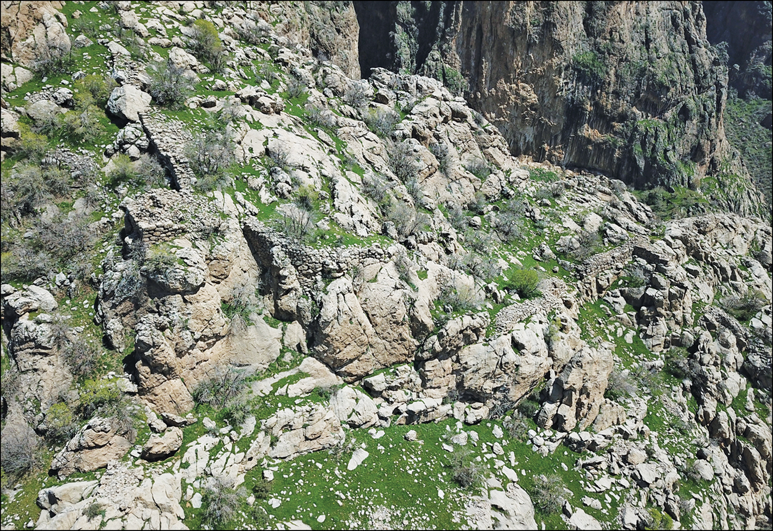
Figure 3. Rabana upper fortifications (© Rabana-Merquly Archaeological Project).
Along the western flank of Merquly, long walls with exterior towers blocked access from the adjacent slope, and together with fortifications along the southern perimeter, defended the intramural settlement. The highest point of Merquly (called Hangazhall by villagers from nearby Zewe) is on its north-eastern side, directly above the head of the Qula-Rash Valley. Close to this point is a right-angled wall with the hollow foundations of a tower on its south-western corner (Brown et al. Reference Brown, Rasheed, Dörr and Heiler2020: 97–98). In conjunction with the adjoining outcrop, this forms a large, fortified emplacement. At approximately 1900m asl, the Hangazhall fortification provides commanding views south towards the strategically important Tasluja Pass and, in combination with the high towers at Rabana, would have enabled comprehensive surveillance of the adjacent Charmaga Valley, including several nearby sites with Parthian-era occupation (Figure 4). This visual command would have provided warning of any impending attack, potentially allowing nearby communities to take shelter within the fortified settlement of Rabana.
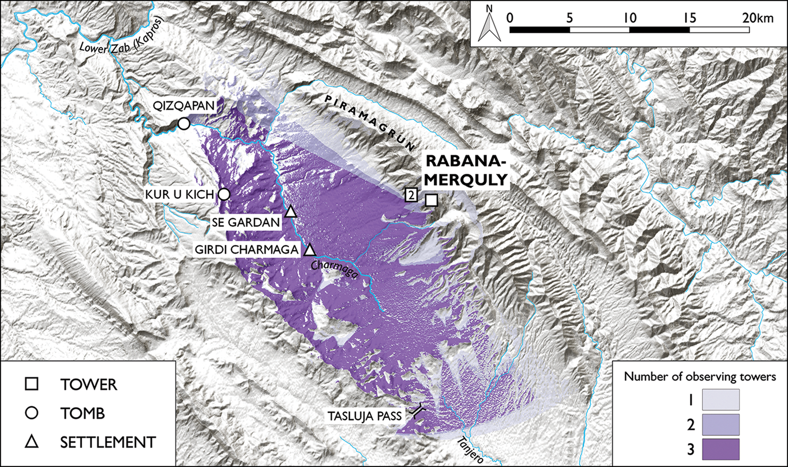
Figure 4. Cumulative viewshed (20km radius) from the three highest towers at Rabana-Merquly (map by M. Brown; © Rabana-Merquly Archaeological Project).
At the south-western corner of the Merquly Plateau, the western and southern segments of perimeter wall abut a large, outcropping rock. Here, on its south side, is one of two matching rock-reliefs, located immediately behind the perimeter wall, near a probable entrance (marked D on Figure 1B). A second relief (marked A on Figure 1B) is positioned in front of a section of perimeter wall, blocking the natural entrance at a corresponding access point to the Rabana Valley (Brown et al. Reference Brown, Rasheed, Dörr and Heiler2020: 93–96) (Figure 5A–B). Overlooked by defensive walls, this extramural public space at Rabana—reached by wide, curvilinear steps—would have allowed for interaction with potentially hostile visitors under tightly controlled conditions, while at the same time signalling the authority of the ruler depicted on the rock-face above.
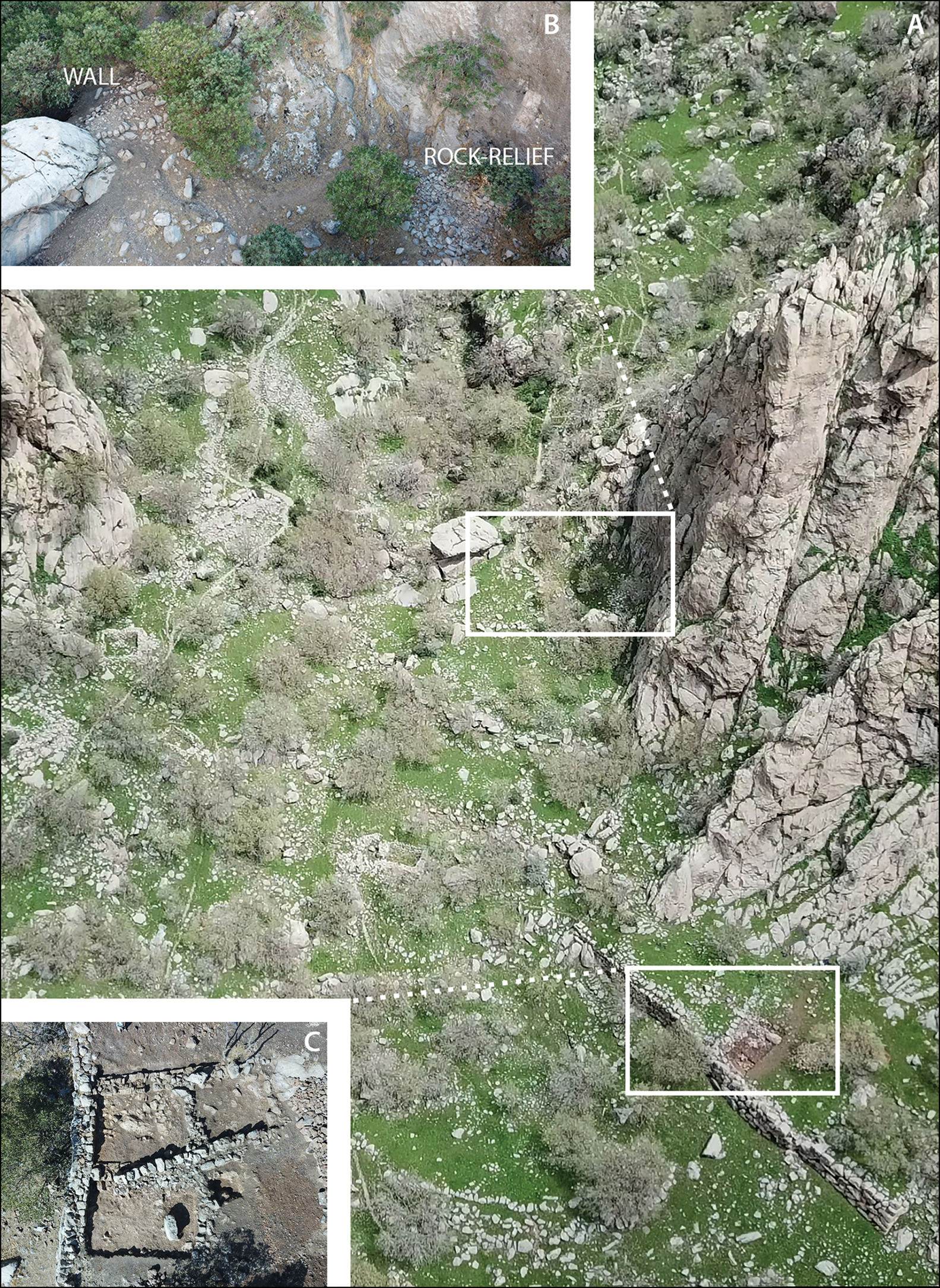
Figure 5. A) Entrance to Rabana Valley; B) Rabana rock-relief with perimeter wall; C) terrace building, showing Islamic-period occupation (© Rabana-Merquly Archaeological Project).
The focus of occupation at Rabana was in the north-east, where the wadi running through the centre of the valley enters from a narrow gorge, starting higher up the mountain. After heavy rain and snowmelt, the entry point of the wadi into the valley forms an ephemeral waterfall, the base of which was canalised within a monumental stone structure (Figure 6A). Here, excavations in 2017 revealed a staircase cut into the bedrock, with Parthian-era ceramics and iron arrowheads deposited on its surface (Brown et al. Reference Brown, Miglus, Rasheed and Ahmad2018: 65, 70 & 73) (Figure 6B–C). Close by, a small (fire?) altar within a sub-rectangular niche is carved into a smoothed section of escarpment (Figure 6D). The overall impression is of a sanctuary complex, with the prominence of water suggesting a cultic link to the Iranian goddess Anahita (Saadi-nejad Reference Saadi-nejad2021: 66). A rock-cut tomb at the nearby site of Qizqapan also depicts a fire altar on its ornate façade (von Gall Reference von Gall1988). Although most probably of earlier post-Achaemenid construction (Boyce et al. Reference Boyce, Grenet and Beck1991: 105), the Qizqapan monument plausibly remained in use as a site for ancestral veneration concurrent with Parthian-era occupation at Rabana-Merquly (Brown et al. Reference Brown, Rasheed, Dörr and Heiler2020: 105, footnote 25), together forming a wider sacred landscape in the Charmaga Valley.
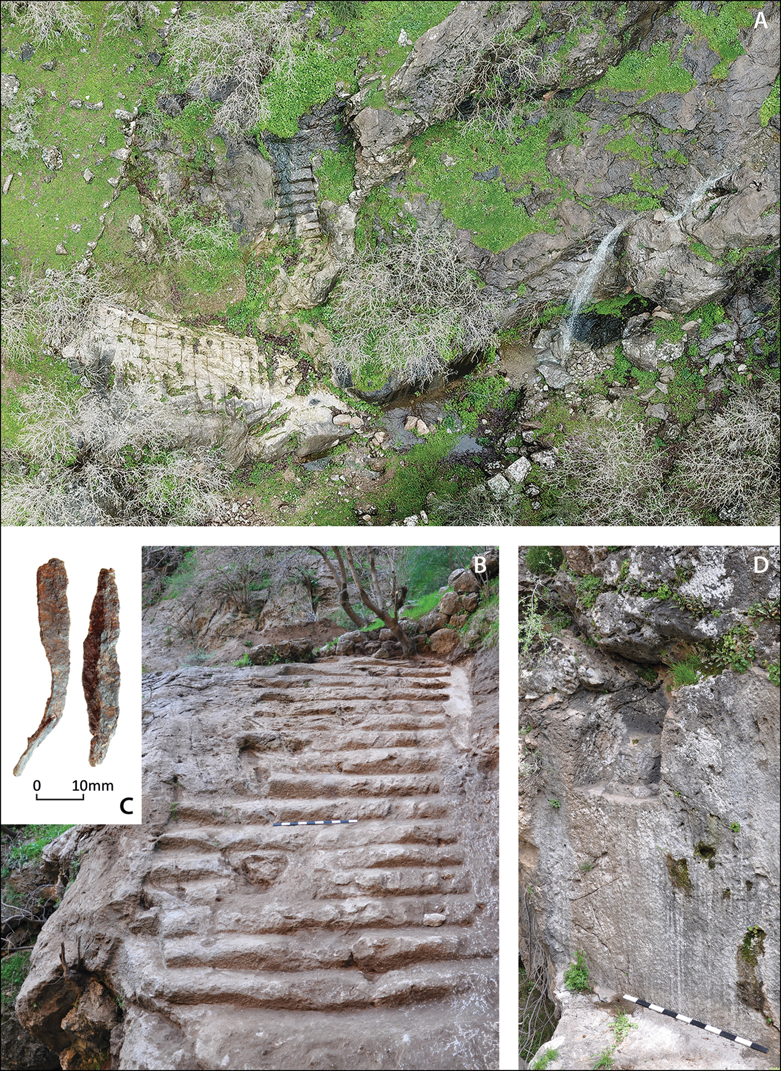
Figure 6. A) Rabana ‘sanctuary’; B) staircase; C) iron arrowheads; D) altar (scales = 1m) (© Rabana-Merquly Archaeological Project).
Excavations of the central citadel at Merquly were conducted by the Sulaymaniyah Directorate of Antiquities in 2009 (Saber et al. Reference Saber, Rejeb and Altaweel2014). The central citadel overlooks 14 freestanding structures that are partially visible on the surface (Figure 7A). These include seven rectangular buildings of standard design, approximately 8–9m wide and 20–22m in length, each with five rooms of roughly equal size. Based on parallels with Roman/Sasanian forts, these structures presumably served, in part, as barracks (Sauer et al. Reference Sauer, Rekavandi, Nokandeh, Lawrence, Altaweel and Philip2020). Of the three examples that were also excavated in 2009, only one immediately below and to the east of the citadel yielded a significant quantity of pottery (Figure 7B). Particularly diagnostic amongst this material are green glazed ceramics that date to the Parthian period, based on parallels from sites including nearby Qalatga Darband (MacGinnis et al. Reference MacGinnis2020: 164–66) and Seleucia on the Tigris (Debevoise Reference Debevoise1934: 34). A further three buildings may represent variations on the ‘barrack’ design, with an approximately 5.5m-wide annex along their northern side. No tiles have been found anywhere at Rabana-Merquly, indicating that roofs were probably of flat, earthen construction.
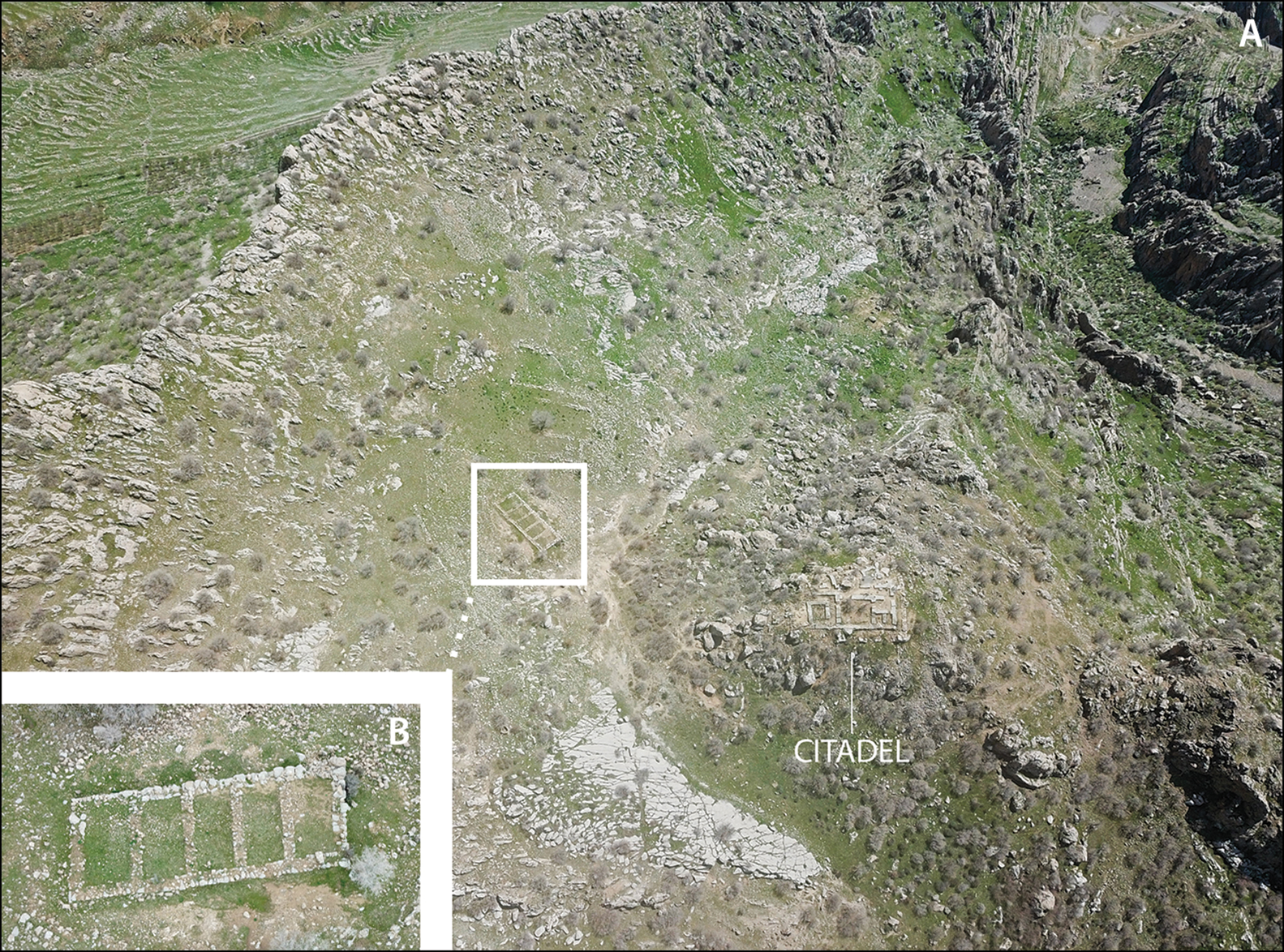
Figure 7. A) Merquly settlement; B) ‘barracks’ building (© Rabana-Merquly Archaeological Project).
The defensive function of the fortress presumably extended to a small garrison at Merquly, which would have been well-placed to counter threats from the west and surrounding highlands. Very limited information is available regarding Parthian military organisation. Parthian demands for compensation to rebuild castella, which was sacked by the Roman emperor Caracalla in AD 216 (Dio Cassius Roman History 79.26.3; Cary Reference Cary1927), indicate that the Empire sometimes shared responsibility with vassal monarchs for the upkeep of frontier defences in northern Mesopotamia. According to Hauser (Reference Hauser, Mode and Tubach2006: 310–11, footnote 72), border fortresses were probably manned by the soldiers of a professional standing army, although it is unknown whether these belonged to the Arsacid King of Kings, vassal kings, satraps (provincial governors), or officials of lesser rank.
The apparent architectural relationship between intramural structures, perimeter walls and the two rock-reliefs at Rabana-Merquly strongly suggests that all, or most, of these features were originally contemporaneous components of a planned, Parthian-era settlement. Minor structural renovations to the Merquly citadel indicate subsequent reuse, although it is uncertain whether this occurred later in the Parthian period or in the subsequent Sasanian period (Saber et al. Reference Saber, Rejeb and Altaweel2014: 236–37). Fortifications at the entrance to Rabana were also augmented as part of a significant Islamic-era (AD 636–sixteenth century) reoccupation of the valley (see Figure 5C).
Rock-reliefs and King ʾtlw/Attalos of Adiabene
Each of the two rock-reliefs at the gated entrances to Rabana-Merquly depicts an approximately life-size ruler in ceremonial headgear comprising an ‘upright’ tiara (or hat) and trailing diadem (Figure 8A–B) (Rasheed Reference Rasheed2001; Amedie & Zamua Reference Amedie and Zamua2011; Brown et al. Reference Brown, Miglus, Rasheed and Ahmad2018, Reference Brown, Rasheed, Dörr and Heiler2020: 99–103; Khounani & Mohammadifar Reference Khounani and Mohammadifar2018). While the absence of accompanying inscriptions makes it impossible to identify the individual(s) with certainty, informed speculation is possible based upon comparisons with other contemporaneous examples of Parthian official art.
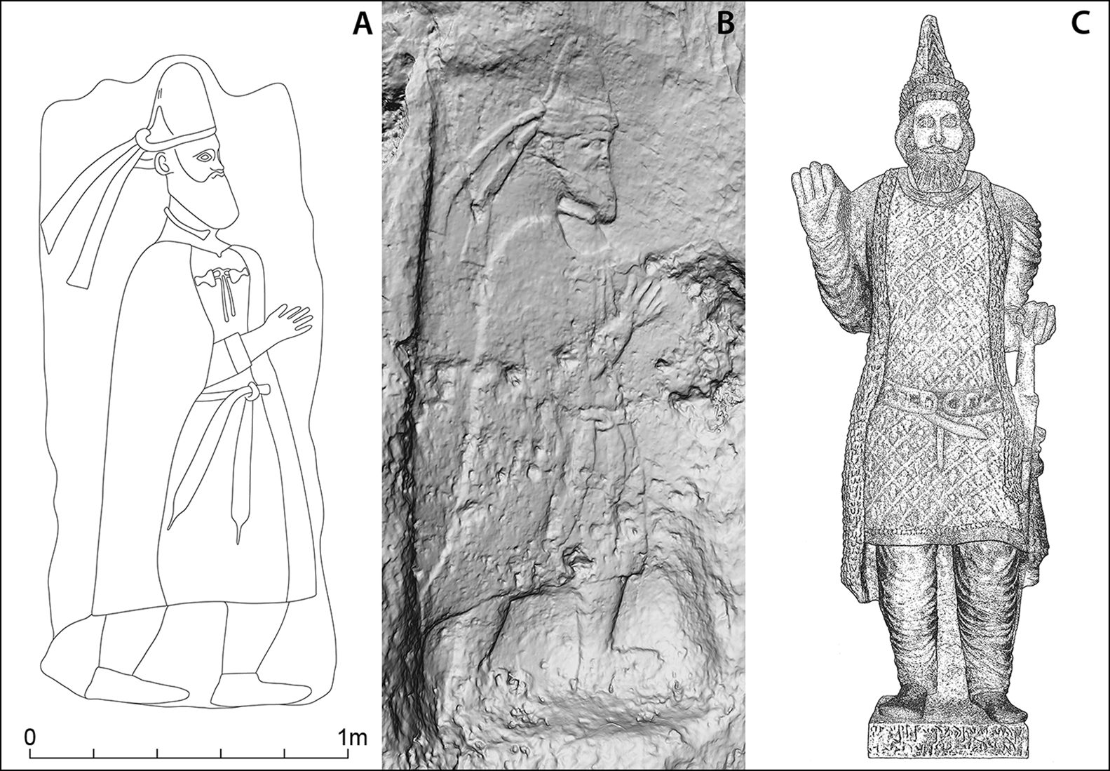
Figure 8. A) Merquly rock-relief; B) Rabana rock-relief; C) statue from Hatra of King ʾtlw/Attalos of Adiabene (illustrations by M. Brown; © Rabana-Merquly Archaeological Project).
Three other rock-reliefs depicting individual Parthian-era rulers are known from the western foothills of the Zagros Mountains: one at Batas-Herir and two at Amadiya (Boehmer & von Gall Reference Boehmer and von Gall1973; Grabowski Reference Grabowski2011; Miglus et al. Reference Miglus, Brown and Aguilar2018; Bahrani et al. Reference Bahrani2019). These three figures all wear diadems and are generally similar in composition to the two from Rabana-Merquly, differing mainly in their headgear, with the Batas-Herir sculpture showing a ‘satrapal’ style of tiara that is associated with the kings of Adiabene (Marciak & Wójcikowski Reference Marciak and Wójcikowski2016: 82 & 84–85). As at Rabana-Merquly, the Amadiya rock-reliefs flank the main entrance to the settlement. The Amadiya and Batas-Herir figures, however, are larger than the life-sized figures at Rabana-Merquly and are shown holding a spear or staff.
Coins provide images of two Adiabenean kings: Abdissar and Monobazos I (Marciak & Wójcikowski Reference Marciak and Wójcikowski2016: 82–83 & 88–89). The earliest attested king of Adiabene is Abdissar, who reigned during the first half of the second century BC and appears on three types of coins wearing a ‘satrapal’ tiara. Monobazos I reigned during the first half of the first century AD and is shown on a single type of bronze coin wearing a ‘dentate’ tiara. While the combination of diadem and ‘upright’ tiara depicted in the Rabana-Merquly reliefs more closely resembles the headgear shown on Arsacid coins, this does not rule out an Adiabenean attribution. Although usually restricted to the Arsacid King of Kings, the right to wear the ‘upright’ tiara was occasionally granted as a privilege to vassals, including King Izates II (r. 55–30 BC) of Adiabene (Josephus Jewish Antiquities 9.20.67; Feldman Reference Feldman1965; Olbrycht Reference Olbrycht1997: 48–49).
By far the closest parallels for the Rabana-Merquly relief sculptures are found in a statue from the city of Hatra, some 230km further west, that portrays King ʾtlw/Attalos of Adiabene (Figure 8C) (Fukai Reference Fukai1960: 142–43; Teixidor Reference Teixidor1967: 1–3; Safar & Mustafa Reference Safar and Mustafa1974: 208; Al-Shawi Reference Al-Shawi1986: 209–10; Marciak & Wójcikowski Reference Marciak and Wójcikowski2016: 92–94). ʾtlw/Attalos is notable for being the only non-Hatrean king depicted at Hatra, leading to speculation that he played an important role in the city's development (Teixidor Reference Teixidor1967: 9). This may likewise apply to his ancestor, Ntwn ͗šr/Natounissar, who is cited in the accompanying inscription (H 21) and in two other Hatrean texts (H 113–114) (Beyer Reference Beyer1998: 33 & 54). The ʾtlw/Attalos statue and the two rock-relief figures from Rabana-Merquly all depict headgear of approximately the same size, fin-like in shape, and with a rounded peak and tied diadem around their bases.
Like the two Rabana-Merquly figures, the Hatra statue wears a full beard. The right arm of all three figures is raised, with an open palm in a gesture of salutation. Each figure wears a torc around the neck. The Hatra figure wears a sleeveless cloak or mantle, as the two Rabana-Merquly figures also probably do where their bodies are depicted in outline. A unique feature of the Rabana-Merquly figures is a clasp that fastens the top of this garment. All three figures wear a belt with hanging tapered ends. The most significant difference in apparel between the Rabana-Merquly rock-reliefs and ʾtlw/Attalos statue is a sword resting on the left hip of the latter—a feature that is also shown on the two Amadiya figures (Amedie & Zamua Reference Amedie and Zamua2011: 237; Miglus et al. Reference Miglus, Brown and Aguilar2018: 119–22).
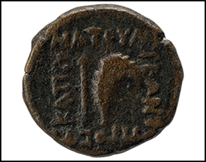
King Natounissar and Natounia on the Kapros
Two considerations raise the possibility of the identification of the Rabana-Merquly fortress as a city called ‘Natounissarokerta’, or ‘Natounia’, with the accompanying epithet ‘on the Kapros’ (Amedie & Zamua Reference Amedie and Zamua2011: 236; Brown et al. Reference Brown, Rasheed, Dörr and Heiler2020: 103–106). These are, first, the similarities between the Rabana-Merquly rock-reliefs and the statue of King ʾtlw/Attalos of Adiabene from Hatra, and second, the broader landscape setting of the fortress close to a major tributary of the Lower Zab River. Both versions of this ancient place name are inscribed on seven known examples of bronze coins from an unprovenanced mint (Figure 9) (Marciak Reference Marciak2013, Reference Marciak2017: 307–308). Similarities with inscriptions from Hatra, including H 21 on the ʾtlw/Attalos statue, are highlighted by Lipiński (Reference Lipiński1982, Reference Lipiński2015: 203–205), who reads Ntwn ͗šr/Natounissar (trans. ‘given by Ishtar’) as a throne name belonging to the founder of an Adiabenean dynasty. To paraphrase, the toponym Natounissarokerta can then be understood as a king's royal name, supplemented with the Parthian term denoting a moat or fortification. Such a description could well apply to the perimeter defences around Rabana-Merquly.
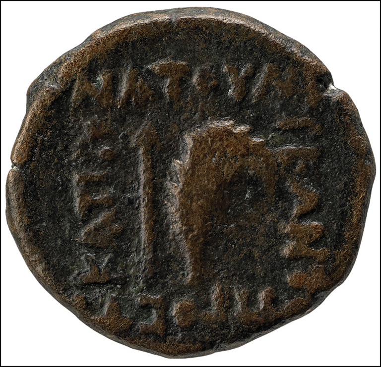
Figure 9. Coin of Natounia, reverse. Inscription: NATOΥN / IEΩN T[ΩN] / ΠPOC TΩ / KAPΠΩ (Marciak Reference Marciak2013: 162–64) (photograph © The Trustees of the British Museum. Shared under a Creative Commons Attribution-NonCommercial-ShareAlike 4.0 International (CC BY-NC-SA 4.0) licence).
Two of the seven inscribed Natounia coins were recovered from a hoard at Nisibis (modern-day Nusaybin in south-east Turkey), on Adiabene's north-west border, that was deposited no later than 32/31 BC (Seyrig Reference Seyrig1955: 100–104). The dates on these coins suggest they may have been minted during the first half of the first century BC (Butcher Reference Butcher1991). Although the ʾtlw/Attalos statue is undated, it was found in the so-called ‘Square Temple’ of the central temenos at Hatra that, according to its dedicatory inscription (H 272), was inaugurated in AD 137/138 (Bertolino Reference Bertolino1995: 39–44; Beyer Reference Beyer1998: 79). While it is conceivable that the portable sculpture could pre-date this building, the gap of 169 or more years between the coins and the dedicatory inscription implies that King ʾtlw/Attalos was not responsible for issuing Natounia's coinage. This does not preclude a more general association with the ruler depicted in the Rabana-Merquly rock-reliefs and another member of the same Adiabenean dynasty who shared their traditional costume. If the equation between Rabana-Merquly and Natounia is accepted, it follows that the rock-reliefs probably depict the city's eponymous founder Ntwn ͗šr/Natounissar, or an immediate descendant. Diagnostic ceramics from Rabana-Merquly are compatible with first-century BC occupation, when Natounia's short-lived coinage was in circulation.
Further potential support for the identification of Rabana-Merquly with Natounia comes from the description of the latter as a royal city of Adiabene ‘on the Kapros’. Rabana-Merquly is located within the watershed of the Lower Zab, which was known as the Kapros in antiquity (Figure 10) (Kessler Reference Kessler1999). This river is approximately 400km long and the land through which it flows is characterised by a sharp decrease in precipitation from east to west, with annual rainfall ranging from approximately 800–900mm around Mount Piramagrun but falling to less than 200mm at its confluence with the Tigris (Buringh Reference Buringh1960: 43). Climate, as well as topography, had a major influence on patterns of riverine settlement in this region. Mount Piramagrun overlooks the floodplain of the Charmaga, which, together with the connecting Surqawshan River, constitutes the largest left-bank tributary of the Lower Zab.
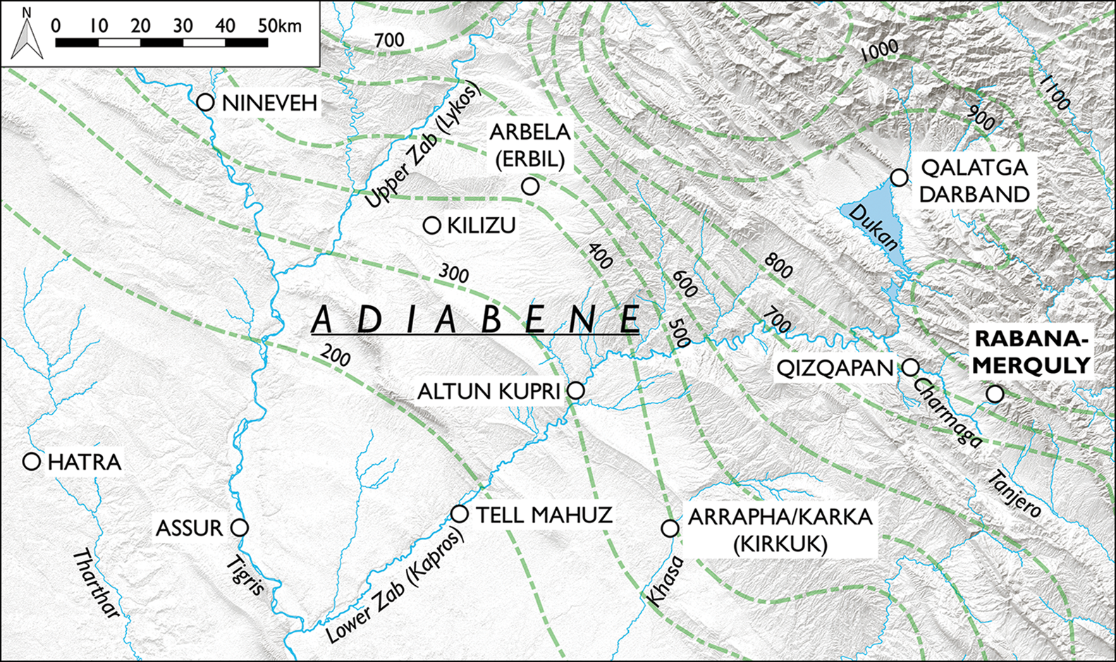
Figure 10. Map of the Lower Zab watershed. Isohyets (annual rainfall in mm) in green (map by M. Brown; © Rabana-Merquly Archaeological Project).
Attaching the names of rivers to place names during antiquity usually served both as a geographical descriptor and to distinguish between two similarly named settlements. In the case of Natounia, this perhaps implies that another site, such as Arbela (modern-day Erbil), the capital of Adiabene, shared the same designation, at least temporarily. Deliberate association with the Kapros River, which was a prominent topographical marker of Adiabene, could also have been intended to validate a new capital by embedding it within an established geopolitical landscape. Although rare, parallels for a more general nominative relationship between sites and the watershed of a river—as opposed only to the main river channel—can be found in the Hellenistic East, at, for example, Ai Khanoum (Alexandria on the Oxus?) and the Amu Darya River basin in Afghanistan and Central Asia (Bernard & Francfort Reference Bernard and Francfort1978: 3–15).
Aside from Rabana-Merquly, the only other known Parthian-era settlement of comparable scale within the Lower Zab watershed is Qalatga Darband. This site is located on flat terrain in the Rania Plain and may have been founded slightly earlier, during the later second century BC (MacGinnis et al. Reference MacGinnis2020: 165–66). Further west along the Lower Zab, a Parthian-era fortress of approximately 1–3ha in size has been investigated on the south bank at Tell Mahuz (Córdoba Reference Córdoba2005: 223). Another possible identification for Rabana-Merquly includes Bdīgar, a fortress of Adiabene mentioned in the fourth-century AD Syriac text Acts of the Persian Martyrs (Jullien Reference Jullien and Gyselen2004: 146; Marciak Reference Marciak2017: 318–20).
Conclusions
Parthian-era fortified sites such as Rabana-Merquly were a relatively short-lived phenomenon, despite the massive scale of their construction, and they represent an outlier to longer-term settlement trends in the north-central Zagros highlands. The very significant resources required for the planning, construction and operation of these sites are nonetheless indicative of state-level agency. If the buildings on Merquly were indeed barracks, as we believe, they provide a rare insight into Partho-Sasanian military architecture and organisation. More generally, such evidence for institutional control contradicts the persistent and arguably unjustified assumption of an innately weak Parthian Empire, which has characterised much scholarship to date (Hauser Reference Hauser, Mode and Tubach2006: 296). In addition to defence and its role as a refugium for neighbouring settlements on the Charmaga floodplain, the Rabana-Merquly complex fulfilled a variety of other functions as a regional centre with low-density occupation (as reflected in its surviving architecture), including as a seemingly important cultic venue at Rabana.
Iconographic similarities between the unnamed ruler(s) depicted in relief at Rabana-Merquly and the statue of King ʾtlw/Attalos at Hatra encourage us to argue for a reliable association between Rabana-Merquly and the kingdom of Adiabene, and, more speculatively, with the site of Natounia on the Kapros. Adiabene is known from historical sources to have expanded its borders between the first century BC and first century AD, within the framework of at least nominal Parthian overlordship (Marciak Reference Marciak2017: 270–71 & 417). The ability of the Rabana-Merquly fortress to survey its surrounding landscape as far south as the Tasluja Pass further implies an extension of Adiabenean authority beyond its core territory between the Upper and Lower Zab Rivers. This connection also highlights the distinct geopolitical role of vassal kingdoms on the periphery of the Parthian—and Roman—Empires in Mesopotamia (Gregoratti Reference Gregoratti, Mæhle, Ravnå and Seland2020), providing insights into the practicalities of territorial control by state authorities in hinterland regions.
Acknowledgements
Particular thanks are due to our colleagues Najmaden Ahmad, Rebin Rashid, Saber Ahmed Saber (Sulaymaniyah), Peter Miglus, Roxana Dörr, Jan Heiler and Leonie Schmidt (Heidelberg), together with Kaifi Mustafa Ali (General Director of Antiquities in Iraqi Kurdistan), Zuhair Rejeb, Abdul Rahman, Mark Altaweel, Mustafa Ahmad, Jarek Piech, Carmen Gütschow, Margarete van Ess and Marta Luciani.
Funding statement
Ongoing investigations (2019–2022) at Rabana-Merquly are funded by the Deutsche Forschungsgemeinschaft (DFG project no. 423891597). Excavations at Merquly in 2009 were supported financially by First Lady Hero Khan. Studies of the rock-reliefs in 2016 were funded by the Gerda Henkel Foundation. A nine-month Transcultural Forays Fellowship awarded to Michael Brown by Heidelberg University's Centre for Transcultural Studies (Cluster of Excellence Asia & Europe) enabled research in 2017–2018. Fieldwork in 2019 was made possible by grants from the Deutsche Orient-Gesellschaft and the British Institute for the Study of Iraq.


 Open access