


In this article, we explore the many innovative ways in which the excitement of archaeological discoveries is being brought to the general public, students, and professionals as part of the regulatory creative-mitigation process. Hint: the archaeological record is processed and interpreted in real time. The Pennsylvania Department of Transportation (PennDOT) and the Federal Highway Administration (FHWA) were planning a long-term, multiphase project to improve and rebuild Interstate 95 (I-95) in Pennsylvania. The work in the Girard Avenue Interchange (Section GIR in the project area), which became the focus of the intensive archaeological investigations, involves the improvement of three miles of highway between I-676 and Allegheny Avenue in Philadelphia, including the reconstruction of the Girard Avenue Interchange (Figure 1). Beyond the highway improvements, construction also includes complete treatment for adjacent surface streets, including sidewalks, bike paths, upgraded trolley stops, greenspaces, stormwater infrastructure, installation of clear sound barriers, public art, and improving access to the Delaware River waterfront (Pennsylvania Department of Transportation 2019).
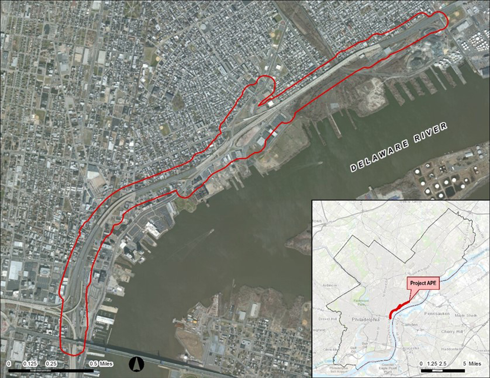
FIGURE 1. Philadelphia I-95 project area (courtesy of AECOM).
Historical lots and streets remain buried below the open spaces adjacent to I-95. Today, within the Northern Liberties, Kensington-Fishtown, and Port Richmond neighborhoods of Philadelphia—where Section GIR is located—there is a high density of standing structures that straddle the western side of I-95 in the form of early- to mid-nineteenth-century brick row houses; two-part commercial structures and the former Port Richmond rail yard dominate the eastern side (Figure 2). These sections of the I-95 highway are either supported on earth embankments with occasional retaining walls or on raised bridge structures, many with numerous piers. Immediately beyond the embankments are the modern businesses and open paved areas adjacent to the highway, reflecting the dense urban nature of the neighborhood, which is still mirrored below in the surface, buried during the original construction of I-95 (for nearby Philadelphia waterfront archaeological studies, see Dworsky et al. Reference Dworsky, Smith, Jones, DiMaiolo and Browning2019; Louis Berger and Associates 1994; Tyler and Weber Reference Tyler and Weber1987; Weber Reference Weber1990).

FIGURE 2. Waterfront neighborhoods (courtesy of AECOM).
I-95 through this section of Philadelphia was built between 1970 and 1979 (Gottlieb Reference Gottlieb2015). As a result, the finished highway created the appearance of a great wall separating the working-class neighborhoods from the Delaware River waterfront. Over 150 historic homes, churches, and businesses were abandoned right before initial I-95 construction. Families, churches, and businesses moved out of the neighborhood because of declining values in real estate. With the National Historic Preservation Act (NHPA) still in its infancy, inadequate historical surveys were conducted at that time (Stewart Reference Stewart2011).
In January 2001, during the first project public meeting, the neighborhood associations expressed interest as to how highway construction would impact their historic resources. At that meeting, the public was told that they would be a part of the NHPA Section 106 process to access and review impacts to any historic resources (Abbot Reference Abbot2004). Five more public follow-up meetings were held in 2002 and 2003 (see project timeline here). Several community groups attended, including the Fishtown Neighbors Association, the East Girard Merchants Association, the New Kensington Community Development Association, the Port Richmond Business Association, the American Street Financial Services Center, and the Richmond Street Business Owners—all of whom were vocal about their neighborhood's historic preservation (see Grant et al. [Reference Grant, Robertson, Robinson and Salzman1982] for local historical association neighborhood history concerns). So, barely more than a generation after I-95's original construction, locals were not bashful in highlighting their lost past at initial neighborhood project meetings. It was clear from the initial public meetings that the Section 106 area of potential effects (APE), or historic study area, encompassed historic neighborhoods built around generationally defined boundaries.
The existing I-95 highway had already done its socioeconomic and historic damage. Generating a solution that would help ease the pain of the next 20 years of highway construction became a critical element of the project. The near-neighbor groups are not as interested in where the next new exit ramp is going; they want to recoup their lost past. The project's status as a federal undertaking, following the typical Section 106 process (involving many steps and lengthy reviews), was bound to cause problems—not only for the construction schedule but also in terms of the significant impact to near-neighbor groups, which feel an ownership of this past. A robust form of creative mitigation is required in successfully constructing this new section of interstate. We are aware that the neighborhood infrastructure cannot be restored, but through creative mitigation, we serve as the historic ambassadors of goodwill to the new highway improvements. Ironically, given the overwhelming public response for historic preservation, there is only one neighborhood historical society, the Penn Treaty Museum (mostly a virtual gallery), focusing specifically on the 1683 Penn Treaty historical event. As professional historical project consultants, AECOM is charged with filling the neighborhood's historic preservation void.
Now, with a more mature NHPA in practice, coupled with my own previous intensive urban archaeological experiences in other sections of downtown Philadelphia, North Jersey, and Manhattan—and given the current complex urban setting—a programmatic agreement (PA) was developed and approved by PennDOT, the FHWA, the Advisory Council on Historic Preservation (ACHP), the Pennsylvania Historical Museum Commission (PHMC, which is the Pennsylvania State Historic Preservation Office), and the Delaware Nation. The PA guides the archaeological subsurface testing for the I-95 GIR highway improvement project. Neighborhood groups and state and local professional organizations were asked to consult as well. The PA was signed in 2006 prior to highway construction.
Initially, it was suggested that some form of citywide archaeological sensitivity study through GIS mapping would be the best approach (see Cotter et al. [Reference Cotter, Roberts and Parrington1992] for some of the known Philadelphia archaeological sites). This recommendation was based on the concept that no archaeological resources would be left intact from the original construction of I-95. This form of creative mitigation, however, overlooks the waterfront neighborhoods’ sense of lost history. The PA approach was considered the best and most innovative. It was specifically developed to streamline the normal archaeological identification and evaluation process required in Section 106 of the NHPA. The PA was also linked to the project's categorical exclusion (CE) National Environmental Policy Act (NEPA) document, especially in terms of public-outreach goals. The NEPA and NHPA Section 106 processes run concurrently, and most of the time, the NEPA public requirements take precedence as the default. In this case, however, the NHPA PA is fulfilling that role. The PA is specifically referenced in the NEPA CE by checking off the appropriate boxes, Section B:A-4 (conclusion of Section 106 consultation) and Section B:C (Section 106 Public Involvement). Although any member of the public has probably participated in one (or both) of these processes in the past, we all know that satisfying public-outreach requirements successfully often requires more than simply holding a public meeting.
The PA's primary goal is to meet design and construction schedules and provide significant cost savings—which it has. All parties that signed the PA agreed that seventeenth- through early twentieth-century domestic and industrial deposits, if found intact, would be considered significant. All parties agreed that any intact Native American sites would also be considered significant. The PA was based on the I-95 Section GIR Phase IA archaeological sensitivity study (PHMC ER 01-8007-101) and an addendum to the Phase IA study, which together encompass a site-specific investigation to guide, locate, and identify archaeological resources within an urban environment throughout the project area (Tull Reference Tull2004a, Reference Tull2005). It was cost prohibitive and impractical to perform fieldwork at every location of anticipated ground disturbance, until a preferred alternative was selected in the design of this undertaking. Highway engineers developed a preliminary design for the recommended build option. As supporting documentation for the PA, the Phase IA study presents a research design that ranks both historical and precontact archaeological resources for the entire project area, along with urban testing methods. The ranking criteria define the site-specific environmental and historical research directed at every location slated for subsurface disturbance in order to determine areas of high and low sensitivity for the location of National Register of Historic Places (NRHP) archaeological resources. The Phase IA report explains which historical lots are most likely to contain information (i.e., part of the archaeological record) that is important to Philadelphia history. The areas that potentially contain precontact archaeological resources, buried beneath deep modern fills and historical sites, are also included in this report. The Phase IA report further identifies the exact locations for Phase IB through Phase II testing, based on a ranking scheme relating the lots to areas that will be impacted during ground disturbance associated with abutments, piers, ramps, rain gardens, et cetera.
The PA stipulates when Phase IB through Phase II archaeological fieldwork will be scheduled and defines the criteria to be used for evaluating archaeological site excavation and sampling. The purpose of the Phase IB through Phase II archaeological fieldwork is to identify any archaeological sites within the project area that may be eligible for the NRHP. The urban environmental setting, safety, site protection, and preservation requires us to open the ground one time and determine NRHP eligibility under Criteria D within days and, in some cases, hours. The NRHP decision meetings are important because they expedite the PA process, resulting in significant cost savings. The NRHP decision makers are cultural resource professionals at PennDOT District 6 and the PHMC, and they are in consultation with AECOM's professional archaeologists. Depending on the potential significance of a site, the NRHP decision meetings can occur via telephone conference with digital images, or they can consist of actual site visits. Although avoidance of impacts to NRHP-eligible resources is the preferred result, treatment of these sites includes one of the following outcomes: (1) Phase III mitigation of the site in the form of more fieldwork samples, intensive background research, and detailed laboratory treatment of the material remains, or (2) if the Phase IB–II effort provided enough of a field sample to adequately mitigate the site, detailed laboratory treatment of the material remains and intensive background research. Overall, this staged approach by highway section and level of effort ensures that this complex project is being carried out in an efficient and timely fashion.
Implementation of archaeological survey and mitigation is conducted in accordance with (1) Section 106 of the NHPA of 1966, as amended; (2) 36 CFR Part 800, particularly sections 800.4, and 800.5; and (3) the PHMC Bureau of Historic Preservation's guidelines for archaeological investigations (PHMC 1991). Work is also conducted in accordance with PennDOT's Directive 430-92-29, dated March 18, 1992. Metric conversions are provided in accordance with PennDOT's Strike-Off-Letter 430-94-25, dated March 15, 1994. In addition, we contacted historical organizations and federally recognized Native American groups (identified by PennDOT) that wished to participate in the Section 106 process. Near-neighbor groups and other organizations were invited to review the Phase IA archaeological sensitivity study and the PA. They were also asked to be involved throughout the duration of the project. The Penn Treaty Museum is one historically focused group that has been consistently and directly involved from the beginning.
The PA provides for much more innovative types of creative mitigation, especially in terms of the immediate dissemination of information to a technologically savvy twenty-first-century audience. Now, the local components of this audience cannot get enough of their neighborhoods’ past and have become so engaged with the project at this point that I-95 construction and design issues are no longer the only focus of public interest. Most near-neighbor groups want to ensure that the archaeological tasks will continue to maintain this exploration of the area's past. To date, 11 Native American sites and 20 historical sites have been identified, exposing numerous precontact hearths and over 400 historical shaft features, and yielding over 1.5 million artifacts. A research design that is dynamic and flexible enough to meet both professional and public expectations is indispensable for the interpretation of the project's extensive archaeological record.
EVERYDAY LIFE, THEN AND NOW
As professional archaeologists, most of us are first trained as anthropologists. Some written history, based only on paper documents, can be published using incorrect logic and unvetted data. Archaeologists attempt to see everyday life in the past the way it occurred on the ground, not only through the lens of written accounts. The practice of archaeology brings together different types of data (e.g., written history, the remains of structures and artifacts, natural history) to understand how societies or cultural groups functioned in the past and changed over time, and there are many diverse theoretical perspectives throughout the profession of archaeology. The relationships between these theories, and often the theories themselves, are not politically neutral. One theory can be more dominant than another at any given time, at any given lecture, at any given professional meeting—and yes, in any given current political climate (Tull Reference Tull2004a, Reference Tull2004b). In terms of a cultural resource management project, theories can also be seen through the lens of project designs and impacts, agency attitudes, and community stakeholders’ concerns.
We are excavating in historically working-class neighborhoods, populated in part by descendants of residents in the distant past. Our research design must include everyone. Many Northern Liberties, Kensington-Fishtown, and Port Richmond folks’ ancestors worked and lived in these neighborhoods for hundreds of years. Native Americans from the Nanticoke Lenape tribal nation (a New Jersey state-recognized tribe on the other side of the Delaware River) still live nearby as well. During research and archaeological excavations, it is imperative to focus on everyday life over thousands of years. Modern-day people want to know about their past, not the past of the notable men of Old City Philadelphia from the Revolutionary War. They want to connect themselves directly with their ancestors, or at least to family names and familiar historical working businesses. Therefore, our research design notes this significance and highlights everyday life.
The Research Design's Basic Premise
The basic premise of the general research design is aimed at restoring the lost history of these neighborhoods. The goal is to re-create neighborhood historical life at distinct points in time and then assess the interruptions and adaptive changes to that life. The focus of inquiry is a simple one, and it pervades the discipline of anthropology: Why does the behavior of human individuals or groups change over time? Are these changes caused by the environment or as a result of technological inventions? Are these changes inherent to culture, trade, religion, politics, population growth, random accidents, or myriad responses to everyday life (Heller Reference Heller1984)?
The general research design is dynamic enough to show a progression of change over time and space, as historical settlement progressed north along the Delaware River away from the city's center. The focus is on points in time (dated material culture) and points in space (opportunistic subsurface disturbances) as they relate to the recovered archaeological record. In this way, the research design can be applied to each archaeological site and those sites yet to be identified. The research design comprises the continuous time period from 8000 BC (based on absolute and relative dating techniques) through AD 1920 within the three waterfront neighborhoods.
Connecting Time and Space before Colonization: A Lenape Acknowledgment
In exploring the past, we are prone to affix undue significance to a solitary historic event when it is removed from its setting and studied apart from its various causes and effects. Conversely, we often stand dumbfounded at the repercussions of some apparently insignificant events: a magnetized needle placed in a marked bowl filled with liquid expands the boundaries of the known world; a new mixture of saltpeter, charcoal, and sulphur changes political borders; hundreds of movable wooden blocks carved as letters help circulate the knowledge of mankind; a meeting under an elm tree along the Delaware River in 1683 at Shackamaxon, Philadelphia, alters relations between nations (the Lenape and English colonists). Rather than isolated, random occurrences, however, the causes leading to such events are usually significant, and the preliminary conditions for their acceptance began decades and perhaps centuries before.
The I-95 GIR project area is located to the north and south of modern-day Penn Treaty Park (where the historic Penn Treaty Elm was located); the precontact archaeological sites are located on landforms that have attracted human settlement for millennia. Given the breadth of history represented there, how do we decide what details are worthy of consideration? Recognizing the original inhabitants of the land is a good start. To the European colonists, the Delaware Valley's waterways became easily recognizable boundaries, but to the Lenape and other Native Americans in the region, the rivers and creeks were the focus of their livelihood. Evidence of Lenape occupation is preserved beneath the ruins of historical sites, such as the Dyottville Glass Works (beginning circa 1771) and the Cramp shipyard (circa 1910), and our excavations are recovering important pieces of the former Lenape presence (Figure 3). From this land, we have excavated reminders of their hunting, trapping, fishing, cooking, knapping, forest clearing, extended trade, and symbolic ceremonies—all part of the original inhabitants’ lifeways.
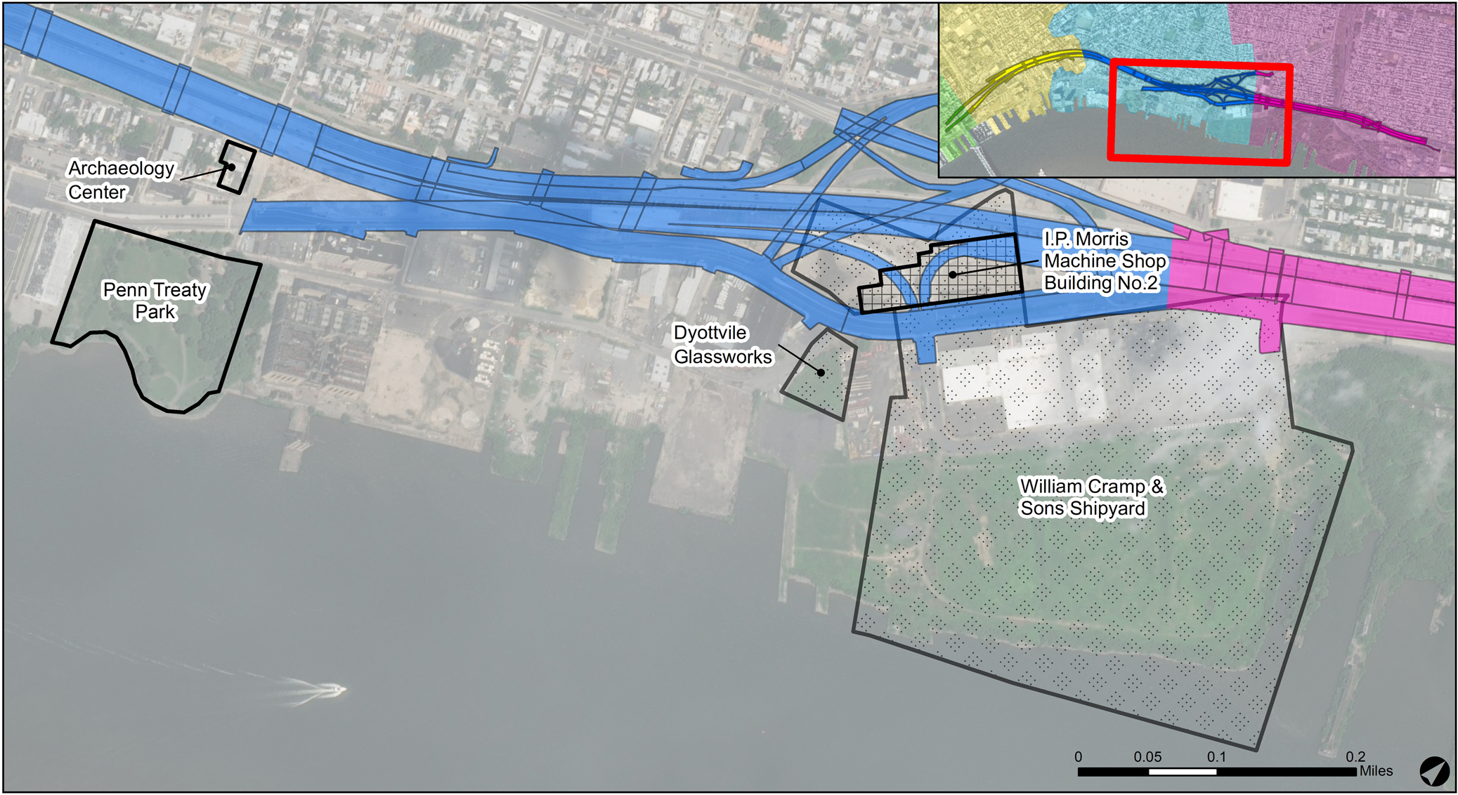
FIGURE 3. General project site locations (courtesy of AECOM).
Daily life played out along this section of the Delaware River waterfront for nearly 10,000 years. AECOM researchers developed a research design to understand Native American activities and describe everyday life along this section of the Delaware River at its confluence with Cohocksink Creek (West Allen Street) and Tumanaraming Creek (Aramingo Avenue). The research model attempts to re-create everyday life at distinct points in time prior to European contact and explain their cultural similarities and differences. The ultimate goal of the precontact research model is to reconstruct Lenape lifeways and place their activities into a regional settlement pattern within the lower Delaware River Valley. With abundant available resources, the Lenape Woodland Indians of southeastern Pennsylvania and New Jersey developed workable political and social forms of organization. Their activities did not pollute the environment or drive any species into extinction. Therefore, if success is measured by environmental and economic stability, the Lenape Woodland Indians would rank extremely high.
The Philadelphia meeting, whether it actually took place or not under the elm tree in 1683, nevertheless created a “Great Treaty” between the Lenape and William Penn's colonists to establish a peaceful coexistence. The agreement (which did actually happen) attempted to provide the basis for relations, and it established expectations of good behavior between the two groups. This great ceremonial gesture, acknowledged at a specific place and time in history, laid the groundwork for valuable future conversations between Native Americans, colonists, and future immigrants. We hope to provide background and context for that momentous meeting on the Delaware and all that came before and after.
Colonial Life Develops Here on the Delaware River Waterfront from the Penn Treaty, AD 1683–1920
To the Europeans, the confluence of the Delaware River and Tumanaraming Creek was a gateway to trade and manufacturing. The creek, which Native Americans had named, was more commonly known to colonists as Gunner's Run, after Gunnar Rambo, an early Swedish settler (the spelling of the creek's named changed over time to end in “er”). We have uncovered a great deal of European material culture from this land because generations of immigrants were instrumental in developing the manufacturing-based economy of the waterfront. For example, the earliest glass factory that later became part of the Dyottville village was established in this location in 1771. Glass manufacturing was so significant, and the factory foundations and artifacts excavated so prolific, that a dedicated thematic context is required for this industry.
The post-seventeenth-century reconstructed historical past of Northern Liberties, Kensington-Fishtown, and Port Richmond is derived from the scientific collection of technological and environmental data, as well as from historical documents. During this time period, new technology was introduced, new natural resources were exploited, the Penn Treaty event occurred, political boundaries were defined and redefined, houses were demolished for factories, streams were sealed and turned into drains and sewers, the riverbank was encapsulated with wharfs and docks, and conflicts occurred. In understanding historical life, scientific and social-scientific approaches can in some cases substantiate these kinds of major events and, moreover, highlight cultural elements of stability maintained for generations in between. In this light, the archaeologist can assist in re-creating social relations while examining material items to understand cultural concepts that reinforced a historical group's lifeways. Various historical groups (i.e., neighbors, immigrants, politicians, industrialists) maintained or imposed new technology or exploited new ecological niches, establishing the degree to which change would occur.
DISSEMINATING THE DISCOVERIES IN REAL TIME
The purpose of creative mitigation in the form of a sustainable neighborhood outreach program here is twofold: (1) to help remind local residents and members of the larger city population that PennDOT is not only working to create a vastly improved transportation system but, at the same time, actively revealing and preserving exciting new chapters of Philadelphia's past; and (2) to gauge public interest in, and support for, a long-term archaeological center interpreting the history and archaeology of the Delaware River waterfront and River Ward communities.
By preserving their heritage and making it physically and intellectually accessible, the FHWA, PennDOT, and PHMC have a rare opportunity to impact the future of these neighborhoods, which have long been underserved in terms of historic preservation. As part of the Philadelphia 2035 citywide planning and zoning project, the Philadelphia City Planning Commission staff spent over 300 hours surveying land use in the River Wards and concluded that only 0.1% was allotted for cultural resources. The need for family-friendly educational and creative places is overwhelming.
AECOM currently partners with community churches and organizations, educational institutions, museums, and other groups to exhibit artifacts from the project and raise awareness of the project's significance. Several museums and universities have expressed an interest in partnering with the I-95 Girard Avenue Interchange Archaeology Center, and we are fostering these and other mutually beneficial relationships to fulfill the Archaeology Center's mission. This section presents our comprehensive sustainable public-outreach program.
Archaeological Fieldwork and Field Tours
Archaeological fieldwork started in 2008. It is ongoing, and it follows the construction schedule. The highway design is divided into eight sections: GR1 through GR8. Our archaeological fieldwork, in most cases, stays ahead of construction. In some cases, however, archaeological fieldwork is conducted in the middle of construction zones. Therefore, archaeological field tours are limited because of safety concerns. Groups usually require hardhats, safety glasses, and vests while on site. Nevertheless, numerous field tours have been conducted (Figure 4).

FIGURE 4. I-95 archaeology field tour (courtesy of AECOM).
Digging I-95 Interactive Report
Archaeological reports associated with data-recovery projects often take many years to complete, and the information is rarely available or understandable to the general public. The Digging I-95 interactive report (AECOM 2014) provides access to enhanced digital information for both the public and professionals in real time, and it is sustainable for many decades (Figure 5). This secure electronic report format satisfies PHMC guidelines, the Pennsylvania State History Code, and Section 106. The data is secure and backed up. Digging I-95 takes an innovative approach to sharing archaeological discoveries from Philadelphia's waterfront with the public, government agencies, and professional archaeologists.

FIGURE 5. I-95 interactive report (courtesy of AECOM).
The interactive report offers dual secure versions: an agency version and a public version. The agency version provides an automated progress report and review access to the reports at the contributing level (full editor) and at the member level (comments only). The public version provides for read-only interactive-friendly navigation and, as required, certain content can be restricted. Both versions provide image-based exploration, map-based navigation, and a query-ready search box with tips for better access control.
PennDOT and PHMC have contributing-level capabilities. They receive an e-mail notifying that a report chapter is complete. The chapter can then be reviewed, with no need to wait until the entire report is complete. This constant feedback loop keeps comments to a minimum, because agency report comments and research directions are provided in real time, and rework is kept to a bare minimum. If project areas expand due to new ground-disturbing construction and/or if monitoring is required, then new information is added to existing site data without report addenda. Member-level comments are considered instantly as well. FHWA and the Delaware Nation are examples of member-level agencies. Significant cost savings are realized in this collapsed review time. Eliminating labor and costs for printing and binding multiple drafts and final versions of reports results in significant cost savings as well. It should be noted that when reports are final, a printed archival version will be provided to PHMC.
The reports are accessed via a website home page that displays a map of the three neighborhoods, a gallery of highlighted artifacts from each neighborhood, a hot button to access a general project overview (including general historical, environmental, and methods information), and an advanced search box. Links to other helpful and informative websites are listed. A highlight of the general historical context is the depiction of each neighborhood's history as a series of interactive historical map overlays with text.
From the home page, a professional user, for example, may select the neighborhood map page, interpreting each neighborhood's archaeological sites. In addition, from the home page, a public user may choose the option to enter archaeological sites via each neighborhood's highlighted artifacts. Each neighborhood landing page is a public interpretation of that neighborhood's archaeological sites. It can, if so desired, also take the user to site-specific environmental and historical data, along with the results of the analysis and interpretation, which include site maps, features, soil profiles, and more—all in standardized tabular and image format viewable through multiple windows. A user can also easily reference the general methods sections. A link is provided to the Microsoft Access database artifact catalog as well.
In addition, this approach enables professionals to analyze and interpret data and the educated public to gain understanding of the archaeological record by performing their own analysis. An important aspect of the I-95 archaeological interactive report is that the professional archaeologist can now analyze data from multiple sites. University professors can now have graduate students pose research questions for future theses. Middle- and high-school educators can now synchronize the archaeological interactive reports with their classroom online whiteboards. And, most importantly, the public has access to the archaeological record now rather than in 5–10 years.
By making use of the latest technology, public visitors can search through and explore this information as they please via their computers or any web-enabled devices. It includes images, 3D reconstructions, and information about individual artifacts; photos and videos of site excavations; historical research on these neighborhoods; stories about the diverse people who made the riverfront their home over the past 10,000 years; detailed neighborhood discoveries from archaeological sites; artifact databases that can be used for further research; and information about upcoming public events featuring the latest project discoveries.
Given the amount of data, the interactive report is broken down into site snapshots, management summaries, and site reports. These summaries and data roll up into a historical neighborhood interpretative report, such as “The Archaeology of Port Richmond.” A separate Native American report will be produced, as well as thematic reports pertaining to glass manufacturing and transportation.
The River Chronicles Journal and Other Hard Copy
With such a robust interactive report, one might ask: “Why a professional journal?” River Chronicles (AECOM 2016) brings information to a much wider audience beyond those who would delve into the interactive report's website. The journal highlights specific noteworthy features and artifacts, providing sharp images and photographs. In addition to bringing an additional layer of excitement to the archaeology project, it provides well-deserved individual recognition, especially for our younger, novice scholars. Journal articles focus on comparative and thematic studies, as well as technological innovations and Archaeological Center activities (Figure 6).

FIGURE 6. River Chronicles (courtesy of AECOM).
Other handouts include the monthly “Artifact of the Month” postcards, which are then conveniently used to create an annual calendar. These items depict some of our most noteworthy and interesting artifacts for public enjoyment.
Collections Management
The volume of site data is at least partially contained in the excavated artifacts, now numbering over 1.5 million. The scale of this project necessitated the creation of a data-driven collections management system to track location and status. The artifact boxes are barcoded and then recorded in a dynamic mobile app, which was designed in house. This approach allows us to track parts of the collection as pieces are washed, marked, cataloged, mended, or removed for specialized analysis. This system is set up so that the whole lab process can be tracked by site, feature, or context-level field specimen number. This data can be used in concert with artifact-level catalog data for the larger-scale analysis of project data (Figure 7). In the long term, we are working toward curating the entire collection within a responsible neighborhood facility rather than having it housed 90 miles away in PHMC's repository in Harrisburg, Pennsylvania.

FIGURE 7. I-95 collections management (courtesy of AECOM).
Historical Social Mapping
An accurate interpretation of the archaeological record hinges on the digitization of Philadelphia's invaluable cartographic resources. The I-95 urban project area was mapped extensively, from seventeenth-century depictions of early plots and the original street grid to modern high-resolution lidar survey and orthophotography. We are able to coordinate deed research and occupation history with a robust geographic information system (GIS) tied to archaeological excavations. Spatial analyses reconstruct historical landscapes and document settlement patterns ranging in scale from a single yard to an entire neighborhood.
High-level comparative analysis is performed by creating relational databases for the artifact catalog and historical records, and then linking them to spatial GIS field records and georectified historical maps. We beta-tested technology-driven relational connections between artifact information, field results, and historical research. With over 1.5 million artifacts and thousands of features, all within three miles of the historical waterfront, it has been no small feat. This ability, however, to connect artifacts to features and historical occupants through social mapping is an invaluable resource that will be used to develop and answer research questions focused on these historical neighborhoods.
Emerging Technologies: Digital 3D Imaging, Printing, and Augmented Reality
For this project, we have developed several integrated technologies working in concert to deliver a holistic level of public interaction and outreach. We achieve this through our dedicated database systems and heuristic interactive report design. Using our 3D scanning technology in concert with ScanStudio, Autodesk ReCap, and Geomagic software packages, we can scan multiple artifacts, large and small. These scanned objects are then meticulously textured and re-created in 3D, with care taken to ensure the fidelity of information in the translation. Our scanned items are also re-created via 3D printing using our in-house system, which is accurate up to 100 nm. Finally, our 3D prints and scanned artifacts are integrated into our augmented reality (AR) pipeline. Using the HoloLens and AR via phone apps, we have created an interactive system that supplements the traditional forms of public outreach (Figure 8).

FIGURE 8. I-95 emerging technologies (courtesy of AECOM).
Our use of AR is twofold. First, our series of smartphone apps—which any user can download and install—work with our published monthly artifact postcards and our annual River Chronicles journal. Through our AR app, users can point their phones or tablets at specific journal pages or postcards and be able to view the 3D scan of an artifact on their screens. They can then rotate and view the artifact in real time, affording them access to more than just the printed surface image. Second, our 3D printing capabilities take this one step further by quickly fabricating replicas of artifacts in a variety of materials, ranging from simple recyclable plastics to more complex ones such as wood, copper, bronze, or t-glase, to name a few. Not only can visitors handle these items, but they can also participate in activities that mimic those of our archaeologists at work. A favorite is the ability to piece 3D printed sherds of “glass” together, allowing visitors to experience how mending occurs.
Our interactive media specialists work closely and in partnership with Drexel University's Media Arts and Design Center and other institutions on a variety of topics, including heuristic user experience, user interface (UX/UI) improvements, 3D printing and fabrication, and augmented and virtual reality (AR/VR) coding and execution.
Historic Architectural Elements
Aboveground architectural elements from the 1910 I. P. Morris Machine Shop #2 (part of the historical Cramp shipyard) have been saved and conserved for landscaping sculpture and functional street furniture. The Morris building contributed to the Fishtown Historic District and was recorded at the state level, which included a video. The Morris building was one of only four historic buildings left standing in the project area after the original construction of I-95 in the 1970s (Figure 9).

FIGURE 9. Historic architectural elements (courtesy of AECOM).
Pop-Up Exhibits and Talks
Project research is revealing not only how the area's architecture and industries evolved over time but also details of daily life, family relationships, and amusing anecdotes. Near-neighbor groups, historical societies, politicians, and professionals have enthusiastically expressed their desire to hear these narratives and have them preserved. Over the past 10 years, AECOM has held over 100 public-outreach events made possible through cooperative partnerships with multiple civic, religious, historical, and cultural institutions. Among the most popular events have been a series of one-day community artifact exhibits, where neighborhood residents could view excavated objects and interact directly with members of the archaeological team. Visitors, numbering up to 600 per event, were enthralled by the artifacts and the history they revealed. Two examples of such exhibits follow.
From the Ground Up: Archaeology, Artisans, and Everyday Life. From April 1 to December 31, 2016, AECOM shared discoveries from the I-95 project in From the Ground Up, an exhibition featured at the Museum of American Glass at Wheaton Arts and Cultural Center in Millville, New Jersey. In addition to Native American artifacts, the exhibition highlighted both the glass industry that once thrived in historical Kensington-Fishtown and AECOM's excavation of a portion of the Dyottville Glass Works. From the Ground Up displayed artifacts dating from the late eighteenth to early twentieth centuries, showing how families living along the Philadelphia waterfront prepared and served their food, lit their homes, cared for the sick, fed their children, and addressed personal and social issues that are still relevant today (Figure 10).

FIGURE 10. Wheaton Arts exhibit (courtesy of AECOM).
Digging the City: Archaeological Discoveries from the Philadelphia Waterfront. In an effort to illustrate how the past still exists beneath the modern landscape, AECOM presented the public exhibit Digging the City from September 2012 to February 2013 at the Independence Seaport Museum in Philadelphia. Displayed artifacts were recovered from the Philadelphia waterfront neighborhoods of Kensington-Fishtown and Port Richmond, ranging from 4,000 years ago through the first half of the twentieth century. The Delaware Tribe of Oklahoma also contributed current Native American objects and art for display, helping visitors understand that they are still present in the modern community. Digging the City gave the interested public a chance to experience the links between the visible world of these neighborhoods and the invisible world of the archaeological record (Figure 11).

FIGURE 11. Independence Seaport Museum exhibit (courtesy of AECOM).
PUTTING ARCHAEOLOGY TO WORK EVERY DAY
The I-95 Girard Avenue Interchange Archaeology Center
Our archaeologists have attempted to fill a void in drawing from the above-mentioned research design's various scientific and social-scientific theoretical approaches that link archaeological data to human behavior. The new I-95 Girard Avenue Interchange Archaeology Center is a working archaeology laboratory for processing artifacts recovered from the surrounding neighborhoods of Northern Liberties, Kensington-Fishtown, and Port Richmond (Figure 12). The Archaeology Center is free and open to the public approximately eight hours per week—currently, Thursdays from 12:00 p.m. to 4:00 p.m. and Saturdays from 11:00 a.m. to 3:00 p.m. Special group tours and programs may be scheduled by appointment and special events are advertised as flyers and displayed prominently at local businesses (Figure 13). The Archaeology Center is located directly across from Penn Treaty Park at the intersection of Columbia and Delaware Avenues (900 East Columbia Avenue, Philadelphia, PA 19125). The center is ADA compliant and can accommodate 50 guests at a time. Free parking is available on the street and in a lot opposite the center's entrance. Penn Treaty Park offers free parking until dark.

FIGURE 12. I-95 Archaeology Center (courtesy of AECOM).

FIGURE 13. Archaeology Center flyer (courtesy of AECOM).
The Archaeology Center reveals our interpretation process to the public. Our written language, exhibits, laboratory stations, interactive whiteboards, and augmented-reality displays are conceptualizing our archaeological observations. The center will help decipher collective individual behavior and community activities of Native Americans, European immigrants, and their descendants performed at various points in the past, creating a portrait of their everyday life along the Delaware River. The center also offers a unique interpretive experience, in which visitors may talk with AECOM archaeologists and follow each step as the artifacts are processed. Visitors of all ages will enjoy hands-on experiences in the Learning Lab and discover more about the excavations and material culture of the past through the artifacts and interactive displays.
In addition, our long-term display in the neighborhood in which the artifacts were recovered allows the public to examine excavated objects up close and see how we curate them in the archaeological laboratory—through washing, marking, cataloging, mending, and analysis. Through the center's partnership with the nonprofit Penn Treaty Museum, a transportation fund is being developed. In-kind donations to this fund and profits from the sales of merchandise will be managed by the nonprofit in a separate account. The transportation funds will be used as “grants” to cover the travel costs of local schools.
Today, the recovery of artifacts from this land substantiates the historical relations between various groups of people. Archaeology can help re-create this history in all of its diversity and richness. History only makes sense if we include everyone, which is what the Penn Treaty symbolically promotes (Figure 14).

FIGURE 14. Public interaction (courtesy of AECOM).
CONTINUING CREATIVE MITIGATION
Based on my past project experience, we wanted the public to see the archaeological results in real time. Under normal Section 106 guidelines, and given the size of the undertaking, at least 10 years would have gone by before a technical report was available—a report read almost exclusively by government agencies. All interested parties and descendant communities want to be involved in the archaeological process as it develops. We meet their request through continuous creative mitigation.
We tell visitors to the Archaeology Center that we need their assistance in decoding human behavior from the archaeological record (see public responses here). The past creates the present. And we, in turn, influence the future through our actions and the way we interpret the past. We are preserving the neighborhoods’ heritage, and we want input from our neighbors, educators, and colleagues. A shared civic space can help us transcend our differences. We cannot tell people what to think about the past, but we can present historical facts as trained archaeologists and help show how societal factors make and influence interpretations.
Archaeologists remove the modern surface to get at the historical contexts of features and artifacts buried beneath their feet. We begin at the recognized surface, and then, as we excavate, things start to get very interesting. Once exposed, artifacts and features offer the longest memories. With a little coaxing, they speak as witnesses of the past. No artifact or feature stands alone, however—each is related to others and dependent on them for context. Some artifacts and features give us aesthetic satisfaction. Others give us a jolt of knowledge that brings us into closer contact with time gone by—the hidden objects and places that filled the hours of people's lives, details that would otherwise elude us.
Archaeology matters. We are putting archaeology to work every day at the I-95 Girard Avenue Interchange Archaeology Center near Penn Treaty Park.
Acknowledgments
I would like to extend thanks to PennDOT District 6 and the Federal Highway Administration as well as all of the AECOM contributors, who have worked tirelessly on the I-95/GIR Highway Improvement Corridor Project to make this award-winning project a cultural resource management public outreach success story. All archaeological field, lab, analysis, reporting, and outreach work is conducted under a National Historic Preservation Act Programmatic Agreement.
Data Availability Statement
All data is available at www.diggingi95.com and www.riverchronicles.com.


 Open access