


Introduction
The effectiveness of conservation interventions cannot be evaluated without proper monitoring. A number of recent studies have highlighted the importance of focusing on the questions of why, what and how to monitor, as well as the importance of adapting monitoring to changing circumstances (Yoccoz et al., Reference Yoccoz, Nichols and Boulinier2001; Nichols & Williams, Reference Nichols and Williams2006). New techniques are emerging that improve the robustness and cost-effectiveness of data collection and analysis (MacKenzie et al., Reference MacKenzie, Nichols, Lachman, Droege, Royle and Langtimm2002; Thomas et al., Reference Thomas, Buckland, Rexstad, Laake, Strindberg and Hedley2009). However, in many areas robust monitoring programmes using contemporary scientific methods are still not being employed because of lack of funds, logistics, skilled manpower, commitment and basic issues of bias and coverage that compromise the interpretation of monitoring results. To address this it is important to recognize the barriers and constraints to better monitoring. There is also a need for an assessment of monitoring methods and their relevance in specific situations. We use a case study of ungulates in Central Asia to explore these issues. Much of the monitoring uses biased and outdated techniques that do not have the reliable power to inform management. Here we consider the constraints under which monitoring in Central Asia operates and discuss feasible and locally appropriate approaches to improve monitoring.
The region
Central Asia is home to a number of ungulate species with contrasting life histories (body sizes, longevities, litter sizes and generation lengths) and habitat selection strategies (Schaller, Reference Schaller1977, Reference Schaller1998; Fox et al., Reference Fox, Nurbu and Chundawat1991). These species include argali Ovis ammon, ibex Capra sibirica, Mongolian gazelle Procapra gutturosa, Tibetan gazelle Procapra picticaudata, kiang Equus kiang, Przewalski’s horse Equus ferus przewalskii, wild yak Bos grunniens, Bactrian camel Camelus bactrianus, blue sheep Pseudois nayaur, markhor Capra falconeri, saiga antelope Saiga tatarica and Tibetan antelope or chiru Pantholops hodgsonii. The saiga was historically abundant and reasonably well managed in Soviet times for trophies and meat (Bekenov et al., Reference Bekenov, Grachev and Milner-Gulland1998). However, following the collapse of the Soviet Union this management programme also collapsed, leading to excessive hunting of saiga, reduction of its numbers by 95% within 2 decades, and categorization as Critically Endangered on the IUCN Red List (Milner-Gulland et al., Reference Milner-Gulland, Kholodova, Bekenov, Bukreeva, Grachev, Amgalan and Lushchekina2001). Although categorized as Endangered (IUCN, 2010), the status of the chiru varies regionally. In some areas its populations are apparently increasing, whereas in others new threats are appearing (Fox et al., Reference Fox, Dhondup and Dorji2009). The major threats include adoption of mass killing methods by hunters using guns and the fencing of pastures by the Chinese government (Fox et al., Reference Fox, Dhondup and Dorji2009; IUCN, 2010). Species such as argali, blue sheep and ibex are still found in large enough numbers to be managed as trophy hunting species, generating revenue for many Central Asian states (Reading et al., Reference Reading, Amgalanbaatar, Mix and Lhagvasuren1997; Shackleton, Reference Shackleton2001; Harris & Pletscher, Reference Harris and Pletscher2002). Relatively abundant species such as the Mongolian gazelle, ibex, kiang and blue sheep are in places considered competitors with domestic livestock by local pastoralists, which is a cause of conflict (Bhatnagar et al., Reference Bhatnagar, Wangchuk, Prins, Van Weiren and Mishra2006; Shrestha & Wegge, Reference Shrestha and Wegge2008), and are also threatened by habitat modification and losses (Ito et al., Reference Ito, Miura, Lhagvasuren, Dulamtseren, Takatsuki, Tsunekawa and Jiang2005; Olson et al., Reference Olson, Mueller, Bolortsetseg, Leimgruber, Fagan and Fuller2009).
The region extends from southern Siberia in Russia to the Greater Himalayas, characterized by cold deserts, semi-arid grasslands, high mountains and plateaux. These highly seasonal systems have harsh winters and hot summers, with peak productivity mainly during a few months in summer (June–August). The ungulate species occur in a multiplicity of habitats ranging from steep slopes to vast open flat plains. Many of these species occur in countries that have either undergone recent economic and political readjustments and hence lack proper monitoring programmes or where long-term monitoring programmes exist but have not been updated to account for changing political or management circumstances. There is a lack of scientific capacity and knowledge of the latest monitoring methods (Norton-Griffiths & McConville, Reference Norton-Griffiths and McConville2007; O’Neill, Reference O’Neill2008; McConville et al., Reference McConville, Grachev, Keane, Coulson, Bekenov and Milner-Gulland2009; Norton-Griffiths, Reference Norton-Griffiths2009). In many places the issue is not just lack of knowledge and capacity but a lack of acknowledgement of the importance of randomization in survey design and of properly accounting for sampling error. This leads to the possibility of misrepresentation of species status and trends, potentially jeopardizing conservation and management goals (McConville et al., Reference McConville, Grachev, Keane, Coulson, Bekenov and Milner-Gulland2009).
Methods for monitoring ungulates
Monitoring methods for ungulates can be broadly classified into four categories based on the medium used for surveys: aerial, ground-vehicular, ground-walked and ground-other. Each of these categories may use transect-based or count-based surveys. The transect surveys may be based on line or strip transects, whereas count surveys may involve track or point counts. Most of these methods aim to sample a part of the population and use the results to make robust inferences about the entire population. Sometimes, however, total counts may also be made within sample blocks (Norton-Griffiths, Reference Norton-Griffiths2009). All monitoring methods come with limitations as well as advantages (Table 1), with the best approach depending on the aims and scale of the survey. These techniques have been discussed in detail elsewhere (Sutherland, Reference Sutherland2006) and we do not elaborate on them here.
Table 1 Advantages and disadvantages of the methods available for monitoring ungulate species, with references.

Ideally, the objective of any monitoring programme is to obtain precise estimates with a low bias for a given level of total survey effort. Milner-Gulland & Rowcliffe (Reference Milner-Gulland and Rowcliffe2007) described two kinds of biases associated with (1) improper selection of representative sampling units of the population, and (2) failure to meet the assumptions of the analysis, both of which may lead to model errors and hence to misleading conclusions. One key issue is detectability. To compare populations over space and time requires a constant detection probability or for changes in detectability to be corrected. Factors affecting detectability of a species include terrain, species biology, climate, time of the survey and observer efficiency (Thompson, Reference Thompson and Thompson2004). Not correcting for detectability results in a biased density estimator and, therefore, faulty inferences about the population in question (Diefenbach et al., Reference Diefenbach, Brauning and Mattice2003; Farnsworth et al., Reference Farnsworth, Nichols, Sauer, Fancy, Pollock, Shriner, Simons, Ralph and Rich2005).
Another categorization is scientific and participatory approaches to monitoring. Participatory, or locally based, monitoring involves local people in monitoring practices. Danielsen et al. (Reference Danielsen, Burgess, Balmford, Donald, Funder and Jones2009) defined categories based on the extent of involvement of people in monitoring. Local involvement can include data collection, survey design and analysis of results and management-oriented decision making. Five types of methods are suggested by Danielsen et al. (Reference Danielsen, Burgess, Balmford, Donald, Funder and Jones2009) as suitable for participatory monitoring: patrol records, transects, species lists, simple photography and village group discussions although, as capacity builds, more technically demanding methods may also be possible. Participatory monitoring can be the first step towards integrated sustainable community management of natural resources for the mutual benefit of biodiversity and human welfare (Townsend et al., Reference Townsend, Borman, Yiyoguaje and Mendua2005).
Challenges in monitoring Central Asian ungulate species
Although there is a range of well-established monitoring methods available (Tables 1 & 2), they are not consistently applied to Central Asia’s ungulates. The main challenges for monitoring include the region’s remoteness, difficult terrain (altitudes to 5,000 m for argali, ibex, chiru, wild yak, Bactrian camel and Tibetan gazelle, and rugged and steep slopes > 45° for blue sheep, ibex and markhor), climate (extreme cold with the minimum temperature in winter falling to c. -45°C), lack of sufficient coverage of the areas inhabited (thousands of square kilometres for chiru, Mongolian gazelle, saiga, argali and Bactrian camel), financial support, logistics, commitment and technical capacity.
Table 2 Advantages and disadvantages of various methods of sampling, with references.

Wide-ranging species
Migratory species such as the saiga, Mongolian gazelle and chiru occur over vast open areas, which would appear to make them good candidates for aerial surveys. However, only the saiga has been regularly monitored by aerial survey (in Kazakhstan). The political circumstances, high altitudes with extreme weather conditions and lack of funds make this method infeasible for chiru and few aerial surveys have been carried out for Mongolian gazelle, also probably because of lack of funds. The aerial survey methods currently in use for saigas have been consistently applied for the past 40 years but have issues of biased detectability. Norton-Griffiths & McConville (Reference Norton-Griffiths and McConville2007) highlighted issues of survey design and coverage, and technical issues with the conduct of the survey itself. McConville et al. (Reference McConville, Grachev, Keane, Coulson, Bekenov and Milner-Gulland2009) highlighted the problem of unaccounted changes in detection bias as saiga population densities and group sizes have declined. The recommendations for improvement contained in Norton-Griffiths & McConville (Reference Norton-Griffiths and McConville2007) have been officially accepted but actual changes are only gradually being implemented.
Saigas are also monitored using ground-vehicular surveys (both in Kazakhstan and in Russia) and so are chiru and Mongolian gazelles. However, vehicular surveys are prone to a number of biases including lack of measurement of sampling effort, sampling restricted to roadsides and overestimation of group sizes (O’Neill, Reference O’Neill2008). O’Neill (Reference O’Neill2008) reported that distance sampling for saigas fails because of their extreme wariness of humans, leading to a humped detection function, and their tendency to travel in linear groups, making estimation of numbers difficult. In contrast, Fox & Bårdsen (Reference Fox and Bårdsen2005) used this methodology for chiru across the Chang Tang Nature Reserve and noted that flight reaction problems eased at distances > 200 m from the transect line. They suggested that population estimates were possible in limited areas with a strict transect organization and layout that samples patchy distributions, in line with the assumptions of line transect methodology (Bårdsen & Fox, Reference Bårdsen and Fox2006). Mongolian gazelles were systematically monitored using long-distance vehicular surveys during Soviet times (Sokolov et al., Reference Sokolov, Dash, Lushchekina and Neronov1982; Lushchekina, Reference Lushchekina1990). Although these surveys provided point estimates of abundance and group size, they lacked information on sampling methodology, effort, precision and bias. In 1994 an aerial survey reported a population estimate nearly double that obtained from ground surveys, highlighting these methodological issues (Milner-Gulland & Lhagvasuren, Reference Milner-Gulland and Lhagvasuren1998; Reading et al., Reference Reading, Mix, Lhagvasuren and Tseveenmyadag1998). Olson et al. (Reference Olson, Fuller, Schaller, Odonkhuu and Murray2005) carried out vehicular distance sampling of Mongolian gazelle over a small area but reported that sometimes vehicular monitoring methods fail when extremely large numbers of animals are encountered moving in large herds. A few studies have used satellite tagging to investigate movement patterns and habitat use of Mongolian gazelle (Leimgruber et al., Reference Leimgruber, McShea, Brookes, Bolor-Erdene, Wemmer and Larson2001; Ito et al., Reference Ito, Miura, Lhagvasuren, Dulamtseren, Takatsuki, Tsunekawa and Jiang2005, Reference Ito, Miura, Lhagvasuren, Enkhbileg, Takatsuki, Tsunekawa and Jiang2006; Mueller et al., Reference Mueller, Olsen, Fuller, Schaller, Murray and Leimgruber2008) but, despite this, a survey for a reliable estimate of the total population has still not been conducted.
Often, the wildlife monitoring and protection agencies in the region are inadequately equipped to sample vast areas, resulting in a lack of sufficient coverage of survey areas and an inability to undertake regular monitoring. In other cases the conduct of the monitoring programme depends on factors that are not directly related to optimizing survey design. For example, the timing of aerial surveys for saiga monitoring in Kazakhstan is determined by the availability of aircraft, by the weather in particular seasons and by the fact that in spring just after the snow melt they are easily visible (because they have their white winter coats against the dark background). Similarly, most of the surveys on the Tibetan plateau are conducted in summer because of the better accessibility and the favourable climate.
Mountain-dwelling species
Difficult terrain in mountainous regions means that logistical constraints are particularly important determinants of monitoring outcomes. In mountainous areas species such as argali, ibex and urial Ovis vignei are often rare, with low and patchy population sizes, undertake altitudinal migrations and are non-randomly distributed in the landscape (Singh et al., Reference Singh, Yoccoz, Lecomte, Cote and Fox2010a). These factors severely limit the number of observations that can be acquired for a given survey effort. Often some of these species may move long distances during a day, which makes it difficult to identify populations unless they are restricted to a limited area. Hence, there is always a trade-off between the survey effort that is feasible given the logistical constraints and the sample sizes required to satisfy assumptions required for rigorous analyses of monitoring data.
Point counts are generally conducted to survey these mountain-dwelling species, using techniques such as vantage points along trails. However, the random placement of vantage points to enable coverage of the entire survey area is a challenge (Nichols et al., Reference Nichols, Hines, Sauer, Fallon, Fallon and Heglund2000). It is also difficult to establish a survey strategy that could cover most of the vantage points in a single day or within a defined period because of the high-altitude environment (low oxygen levels prevent intense sampling from walked surveys) and the deceptive distances in these landscapes. Local weather conditions may play a defining role when conducting point counts as detectability of animals is extremely variable at high altitudes. Animals may shelter from the heat in the middle of summer days, making them hard to see, and unexpected snow events and fog may suddenly decrease detectability in winter. Most mountain ungulate species are sexually dimorphic, with strong sexual segregation, leading to biases, particularly during the late spring birth period when females conceal themselves. This problem may also be encountered with other survey methods.
Transboundary populations
Many ungulate species in the region occur in transboundary populations (argali, chiru and wild yak in India–China; argali in Mongolia–Russia; argali and kulan Equus hemionus in China–Mongolia; Marco Polo sheep Ovis ammon poli in China–Afghanistan–Pakistan; saiga in Kazakhstan–Uzbekistan) and this can lead to a major hurdle to systematic monitoring if the political atmosphere is unstable. In many cases species populations may be threatened by different factors, and managed differently, on either side of the border, which makes monitoring by one party difficult. Often, the political atmosphere in the entire region is delicate, economic conditions are poor and monitoring methods for the same species in different countries do not match, making reliable estimates of populations and their distribution difficult. For example, the proportion of the saiga population migrating over the border from Kazakhstan to Uzbekistan each winter is unknown because simultaneous counts on each side using the same methods are not undertaken; this is particularly problematic because the location of the bulk of the population with respect to the border on the survey date varies from year to year depending on the weather. Political problems also often result in prohibitions on general access to areas where many of these ungulate species occur. For example, populations of argali, kiang, chiru, Tibetan gazelle and markhor often occur in the border areas between India, China and Pakistan, which are made practically inaccessible because of the presence of the military, preventing any kind of regular monitoring. Any kind of research in these areas requires permissions from central government, which often takes long periods of time and excessive paperwork. Such situations often lead to uncontrolled poaching because of lack of any anti-poaching patrols.
Political will
A number of development agencies (UN Development Programme, World Bank, Deutsche Gesellschaft für Technische Zusammenarbeit, Global Environment Facility, UN Environment Programme) and non-governmental organizations (Wildlife Conservation Society, WWF, Frankfurt Zoological Society, BirdLife) are actively involved in wildlife conservation activities in the region alongside local governments, including ungulate monitoring. These organizations may fund research and monitoring activities and provide technical expertise for surveys, as well as capacity building and logistical support. However, many of these programmes are short-term in their funding and do not manage to convince government of the need for continued implementation of rigorous monitoring. Hence, the long-term sustainability of new monitoring programmes is threatened once donor funding ends. An example is aerial surveys in Kazakhstan: the donor funding enabled the problems to be identified and a staged approach to improving the surveys to be agreed (Norton-Griffiths & McConville, Reference Norton-Griffiths and McConville2007) but without the political will for the government to implement these recommendations.
Improving monitoring
Despite the seriousness of these various challenges there are a variety of ways in which they may be overcome (Table 2). Provision of better equipment, logistical support, training in sampling theory and monitoring methods by governments, research institutions and donor agencies can help overcome the practical difficulties of insufficient funding, skilled manpower and logistics. However, a change of culture is also needed. We outline below the key changes that are required.
Clear objectives
Defining clear objectives is crucial both for justifying financial support for monitoring and for promoting local engagement (Yoccoz et al., Reference Yoccoz, Nichols and Boulinier2001, Reference Yoccoz, Nichols and Boulinier2003). The same applies to the choice of variables to be monitored and achieving a simple link between the data obtained from monitoring and provision of management-relevant information. Clear objectives assist in assessing the trade-offs required between robustness of the monitoring programme and its feasibility given the limited resources available. For example, if a precise estimate of population size is the main aim of a survey then sampling intensity should focus on strata that may contribute most towards the estimate. If, however, we want to know where to locate conservation activities we could focus on surveying the best habitats, to reduce the survey effort required, while still obtaining a reasonable population estimate (Singh et al., Reference Singh, Yoccoz, Bhatnagar and Fox2009). A crucial step is to identify how many units need to be surveyed, using a given method, to obtain a reliable estimate of abundance or any other relevant measure of population state.
Achievable modifications to current methods
Slight modifications in the design of current monitoring methods can yield reasonable results, increase precision and reduce survey effort. Survey effort is often a key issue in Central Asia, where tremendous effort is invested in obtaining reasonable sample sizes. Using approaches such as stratified random sampling based on habitat suitability or predictive models holds promise in identifying crucial areas for monitoring of species that inhabit precipitous terrain or occur patchily over vast areas. Simple random sampling may yield too few observations for mountain species and too variable an estimate for wide-ranging herding species. However, the critical issue with stratified random sampling is the basis for defining strata. Strata in stratified random sampling should be designed so as to maximize the variation between strata and minimize the variation within strata, and this is clearly dependent on season for Central Asian species. Using habitat suitability models provides an answer to this issue. Singh et al. (Reference Singh, Yoccoz, Bhatnagar and Fox2009) used this approach to define the strata for surveying Tibetan argali Ovis ammon hodgsoni during summer in India. The stratified random sampling approach appeared to be efficient in terms of reducing the initial sampling bias of selecting the sampling units and resulted in reduced effort in terms of sampling time in the field. The approach when repeated over time has good potential for including unsurveyed but potentially inhabited areas in future surveys and improving population estimates by increasing detections.
One strength of the approach used by Singh et al. (Reference Singh, Yoccoz, Bhatnagar and Fox2009) is that it is presence based. Often, it is simpler to collect presence data than proving species absence, and this kind of data is most frequently available from sources such as rangers, local people and past records from reports and the grey literature. Singh et al. (Reference Singh, Grachev, Bekenov and Milner-Gulland2010b) used 40 years of presence-only data from the fieldwork reports of the Institute of Zoology, Kazakhstan, to demonstrate that the location of saiga calving areas is now more strongly determined by the avoidance of human disturbance than by environmental factors. Nevertheless, important points to consider while undertaking presence-based surveys is to record the sampling effort and areas visited, regardless of whether the species was actually seen in those areas (O’Neill, Reference O’Neill2008).
A viewshed analysis (which identifies the area that can be seen from one or more observation points or lines) of the surveyed vantage points may allow a preview of the parts of the study area that are visible from a given vantage point or trail. This may then assist in selection of appropriate vantage points to enable full coverage of the survey area or survey blocks while conducting point counts. In addition, it may also allow prior identification of number of survey units and sampling strategy required to get a reliable estimate of the desired population metric. Bhatnagar et al. (Reference Bhatnagar, Wangchuk, Prins, Van Weiren and Mishra2006) used a viewshed approach to survey the kiang in the Ladakh region of northern India. Other challenges with point counts may be dealt with by careful planning of surveys, using stratification to split the survey effort. If the species is sexually segregated during summer, then winter may be a better period to monitor populations, when both the sexes are together, despite the weather-related challenges.
The availability of free satellite imagery can help improve monitoring protocols and prior identification of survey areas depending on the aim of monitoring. High-resolution land use maps from the Geocover project (MDA Federal, 2004) and digital elevation models are freely available at fine resolutions (10–90 m; USGS, 2004; ASTER GDEM, 2009). These images are ready to use and hence provide the best available tool to prioritize areas for monitoring, such as specific mountain peaks and surrounding areas, valleys, trails, ridges, areas of human use and water bodies, before going to the field. In addition, these digital maps and models can be directly used as layers in the formulation of predictive models for habitat suitability and the distribution of species, which can then be translated into a stratified random survey design (Singh et al., Reference Singh, Yoccoz, Bhatnagar and Fox2009).
Central Asia has an extreme climate and this often limits monitoring to spring and summer, when the weather is most favourable. However, other methods could be considered that utilize winter conditions, such as snow tracking, which can provide reasonably good estimates of animal presence and abundance in a cost-effective manner (D’Eon, Reference D’Eon2001; Sulkava & Liukko, Reference Sulkava and Liukko2007). This approach is used in Uzbekistan for the saiga. A mark-recapture method is currently being used for argali and ibex in a relatively small protected area in Mongolia (Reading et al., Reference Reading, Kenny, Amgalanbaatar, DeNicola and Wingard2009).
Monitoring more than just abundance
Practicality in the face of limited capacity dictates that monitoring programmes should also focus on the questions that need urgent attention rather than on more general ecological questions. A key requirement is to monitor the factors affecting population dynamics or causing a population’s decline. These may include poaching, habitat modification, disease, predation, rainfall, productivity and extreme climatic events. In rapidly declining populations monitoring may also focus on the age structure, survival or fecundity of particular age classes. Kuhl et al. (Reference Kuhl, Mysterud, Grachev, Bekenov, Ubushaev, Lushchekina and Milner-Gulland2009), for example, demonstrated that placental counts in saiga birth areas provide a reliable estimate of twinning rate, which itself is a proxy for population age structure and, through that, potentially, for population growth rate.
For the Mongolian gazelle substantial progress in understanding its ecology has been made by monitoring programmes that use satellite-tagged individuals in the absence of reliable abundance estimates. The insights gained into habitat use and movement patterns now hold the potential for structuring a more realistic abundance monitoring strategy based on habitat suitability models (Olson et al., Reference Olson, Mueller, Bolortsetseg, Leimgruber, Fagan and Fuller2009).
Participatory monitoring
Participatory monitoring is gaining popularity as a way of engaging local people in the management of their resources while also generating valuable ecological data (Danielsen et al., Reference Danielsen, Burgess and Balmford2005, Reference Danielsen, Burgess, Balmford, Donald, Funder and Jones2009). In Central Asia uptake has been relatively slow because of the remoteness of the region, its sparse human population, the tendency for authoritarian centralized governments to control resource management and hence the lack of a tradition of officially recognized community organizations.
However, the approach has been tested for saiga populations outside protected areas in Kalmykia and Uzbekistan and shows promising results (Whitebread et al., Reference Whitebread, Obgenova and Milner-Gulland2008; Bykova & Esipov, Reference Bykova and Esipov2009). Local people are supportive and their observation skills are comparable to those of rangers. The public engagement aspect is particularly important for wide-ranging species threatened with heavy poaching, as by necessity a large proportion of their population occurs outside protected areas (Leon, Reference Leon2009). This approach is replicable for other Central Asian ungulate species. A more general participatory biodiversity monitoring programme is being tested among local herders in Mongolia (J. Jamsramjav, pers. comm.), which has the potential to extend monitoring coverage with concomitant conservation benefits.
When several methods are used, such as participatory monitoring, ranger-based monitoring and one-off scientific surveys, the challenge is to combine these data sets to make inferences. This is difficult when the data are collected with different biases and objectives and at different spatio-temporal resolutions. Methods for calibration of participatory monitoring with other forms of data are increasingly available (Oba et al., Reference Oba, Byakagaba and Angassa2008; Rist et al., Reference Rist, Milner-Gulland, Cowlishaw and Rowcliffe2010).
Political will
Despite the seemingly ever-changing political and institutional circumstances in the region, mutually cooperative initiatives need to be taken by the countries sharing transboundary populations and efforts need to be made to prevent poaching and undertake regular monitoring using agreed methods. Such efforts are currently underway to some extent in many parts of the region, following the lead of global biodiversity treaties and international promotion of the peace parks concept. For example, Kazakhstan and Uzbekistan have recently signed a bilateral agreement for the conservation of their transboundary saiga population and scientists from the two countries have started to undertake joint surveys.
Monitoring ungulates in Central Asia: the future
There are a range of well-tried monitoring techniques available that can be adapted to meet the challenges of monitoring the ungulates of Central Asia. The most appropriate depends on the situation (Table 3). When animals occur in open and rolling landscapes and there are sufficient funds available, aerial surveys are the best method (Fig. 1). Where funds are insufficient, and equipment and trained manpower unavailable, ground surveys may be the best alternative, as long as they are well designed. In rugged and mountainous terrain, point counts from vantage points on trails may provide a reasonable estimate for argali, ibex and blue sheep if the points are designed to cover the entire survey area by using prior identification of the survey area and sampling strategy (Table 3).
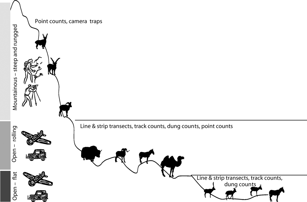
Fig. 1 A schematic presentation for adopting relevant monitoring methods for the habitats and ungulate species of Central Asia. From the top: markhor Capra falconeri, ibex Capra sibirica, blue sheep Pseudois nayur, wild yak Bos grunniens, argali Ovis ammon, kiang Equus kiang, Bactrian camel Camelus bactrianus, chiru Pantholops hodgsoni, Mongolian gazelle Procapra guttorosa, saiga Saiga tatarica and again kiang. The purpose is not to show an elevational gradient, as many species occur at a range of altitudes.
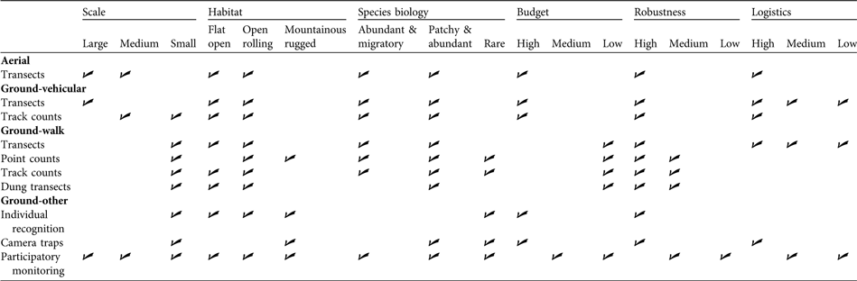
Table 3 Monitoring strategy matrix for Central Asian ungulate species based on various criteria. The table suggests the kind of strategy that may be relevant for a given monitoring situation defined by scale, habitat, species biology, budget, robustness and logistics. For example, if the survey area is large, aerial line or strip transects may be appropriate; when habitat is mountainous and rugged, point counts may be appropriate.
The first step towards improving monitoring is to realize the importance of the quantification of error in population estimates, acknowledge the potential sources of bias, and record the survey or sampling effort undertaken. The examples of both argali and saiga demonstrate that slight modifications to existing survey techniques can potentially increase the power of monitoring programmes to detect changes. If methods improved monitoring effort could be substantially reduced. For example, aerial surveys of saiga populations in Kazakhstan may not be required annually but could potentially be carried out every 3–5 years, as long as the estimates generated are robust. Regular evaluation of existing monitoring methods through power analyses is a useful way of assessing whether current monitoring is capable of detecting policy-relevant trends. For example, the memorandum of understanding on saiga conservation under the Convention on Migratory Species has a 5-year goal of stabilization of the saiga population (CMS, 2006). However, current monitoring methods do not have the power to detect short-term, relatively small-scale, trends and so it is as yet not possible to evaluate whether range states have achieved this goal (McConville et al., Reference McConville, Grachev, Keane, Coulson, Bekenov and Milner-Gulland2009).
In Central Asia there is an impetus to establish new conservation regimes, with new laws, protected areas and monitoring programmes being rapidly established (e.g. the Altyn Dala Conservation Initiative; Klebelsberg, Reference Klebelsberg2008). It is vital that these initiatives are based on sound science before it is too late to influence policy (Joly et al., Reference Joly, Rodrigues, Metzger, Haddad, Verdade, Oliveira and Bolzani2010). Current knowledge and monitoring approaches in this region are in many cases inadequate to support decision makers. Given this, and given the threatened status of several of the ungulate species, and inferred population declines, developing robust monitoring methods is a priority (CMS, 2006). Here, we have identified ways in which existing monitoring methods can be improved without major overhaul. These methods are locally accepted, logistically practical and relatively cheap. In the absence of funding and technical support for an entirely revamped monitoring programme that is truly fit for purpose, there is scope for working to improve what is already available so that the estimates produced are robust, comparable between areas and years and relatively unbiased.
Conclusions
The challenges we have identified in this review are endemic within many of the current monitoring programmes in Central Asia, as is probably also the case elsewhere where resources and technical capacity are in limited supply. However, often relatively simple and cost-effective remedies are available that can dramatically improve the precision and accuracy of monitoring. In many areas, therefore, the technical problems with existing monitoring systems are relatively easy to resolve. More difficult, however, is to change the culture of monitoring. The future of monitoring lies in improving in-country awareness of the need for appropriate survey design, minimization of, and accounting for, bias, statistically rigorous analysis and hypothesis testing. Awareness needs to be improved both amongst scientists and amongst those who fund and implement monitoring. Until this happens, improved funding, external technical support and consultancy reports will not improve the situation.
Acknowledgements
This paper was stimulated by the symposium Combining participatory and scientific approaches to monitoring Central Asia’s ungulates at the Society for Conservation Biology’s 2008 meeting in Beijing. We thank the participants and speakers, particularly Joel Berger, Joe Fox, Takehiko Ito and Jiang Zhigang, who also provided valuable comments on an earlier version of this article. We also thank Mike Norton-Griffiths, Nigel G. Yoccoz, Sumanta Bagchi and Yash Veer Bhatnagar for their helpful comments. This research was supported by the Leverhulme Trust and by a Royal Society Wolfson Research Merit Award to EJM-G.
Biographical sketches
Navinder J. Singh and E. J. Milner-Gulland work on optimizing monitoring as a conservation tool. Both are interested in monitoring and conservation of ungulates in Central Asia and currently study the saiga antelope’s long-distance migrations in Kazakhstan, Uzbekistan and Russia. E. J. Milner-Gulland also studies population dynamics of exploited species and the incentives of the people who hunt them.


