


INTRODUCTION
The Carpathian Basin in the Bronze Age is generally characterized as a period of cyclical shifts of population aggregation and dispersion between approx. 2700/2500 and 900/750 BC (Visy Reference Visy2003; Marková and Ilon Reference Marková and Ilon2013). Historically, researchers paid most attention to the Middle Bronze Age (approx. 2000/1900–1600/1450 BC), when multi-layered settlements become one of the primary forms of land occupation, marking the peak in human activities in the region (Gogâltan Reference Gogâltan1999, Reference Gogâltan2017; Kienlin Reference Kienlin2015; Staniuk et al. Reference Staniuk, Jaeger, Kulcsár, Taylor, Niebieszczański and Müller2020). The second most intensively explored part of the Bronze Age sequence is the Late Bronze Age (1600/1450–900/750 BC), when large cemeteries linked to the Urnfield phenomenon became widespread (Przybyła Reference Przybyła2009; Kalicz-Schreiber Reference Kalicz-Schreiber2010). While these two periods are relatively well-defined due to the abundance of archaeological finds, the periods leading up to their formation remain enigmatic (Bóna Reference Bóna1963; Kulcsár Reference Kulcsár2009; Vicze et al. Reference Vicze, Poroszlai and Sümegi2013).
Until recently, the theoretical basis for the archaeological sequence of the Carpathian Basin has been the assumption that changes in material culture correspond to the arrival of distinct ethnic groups (Kalicz Reference Kalicz1968; Bóna Reference Bóna1975; Kovács Reference Kovács1977). This axiom had two consequences for the interpretation of regional and site-specific trajectories. On a regional level, it led to complex periodization schemes with trajectories explained by migrations and development of the aforementioned groups (Kalicz Reference Kalicz1982; Bóna Reference Bóna1992). On a site-specific level, the connection of material culture with specific groups lead to interpretation of changes in ceramic inventories in settlement layers as indicators of population changes (Máthé 1992; Poroszlai Reference Poroszlai1992; Stanczik and Tárnoki Reference Stanczik and Tárnoki1992). Methodologically, the study of material culture changes was conducted on the basis of implicitly defined types of vessels or metal objects with changes following the trajectory of increasing elaboration followed by decreasing frequencies in the archaeological record (Vicze Reference Vicze2011; Gömöri et al. Reference Gömöri, Melis and Kiss2018). Applied primarily to burial finds, this chronological model proved challenging to implement for settlement finds, where the frequency of intact vessels is substantially lower (Máthé 1984; Michelaki Reference Michelaki2008; Staniuk Reference Staniuk2020). Despite these empirical obstacles, the trajectories developed on the basis of cemetery finds were rigorously applied to settlement materials, equalizing the chronological positioning of cemeteries and settlements alike.
The increasing presence of radiocarbon dating was initiated in the 1990s with the first dating programs providing an independent way of testing the developmental sequences by positioning them in real time (O’Shea Reference O’Shea1992; Raczky et al. Reference Raczky, Hertelendi and Horváth1992; Forenbaher Reference Forenbaher1993; Barta Reference Barta2001). Focusing on tell settlements, these first 14C-dating programs showed the high degree of contemporaneity of Middle Bronze Age sites. However, a larger number of sites and contexts have been dated since the 1990s, indicating possible differences in chronological positions of previously, contemporaneously considered cemeteries and settlements (Duffy et al. Reference Duffy, Parditka, Giblin and Paja2019; O’Shea et al. Reference O’Shea, Parditka, Nicodemus, Kristiansen, Sjögren, Paja, Pálfi and Milašinović2019). Rather than stimulating a discussion towards re-evaluation of the existing schemes and concepts, the possibility of synchronizing phenomena across Europe lead to a consolidation of the existing schemes in order to enable narrative-driven investigations of social processes taking place across Europe (Kristiansen and Larsson Reference Kristiansen and Larsson2005; Earle and Kristiansen Reference Earle and Kristiansen2010; Fischl et al. Reference Fischl, Kiss, Kulcsár and Szeverényi2015). While the reliance on radiocarbon dating was generally embraced by researchers focusing on the Early and Middle Bronze Age, Late Bronze Age contexts remain dated primarily on the basis of typochronology. Therefore, if a radiocarbon-based model of the Carpathian Basin is to be currently provided, it has to be restricted to the Early and Middle Bronze Age sequence.
The shift towards radiocarbon dating allows the reformulation of old research questions and moving away from synchronizing artifact assemblages towards understanding regional developments. This in turn provides the possibility of developing new chronological perspectives on social development and comparative analysis of their compatibility with the existing narratives. To this end, it is necessary to evaluate the existing record of 14C determinations in order to identify the most informative datasets and provide a general perspective on the available data.
This paper collects and investigates the existing dataset of the radiocarbon dates for the Early and Middle Bronze Age Carpathian Basin in order to answer the following questions:
-
(1) Was the emergence of tell settlements contemporary across different regions?
-
(2) What is the temporal relationship between burial contexts and settlements in the different regions?
The collected dataset is evaluated in terms of spatial distribution of determinations, their contextual information, and the standard deviation of measurements in order to propose the most reliable dataset for the study. Kernel Density Estimation plots (Bronk Ramsey Reference Bronk Ramsey2017) are then used to recognize the chronological dynamics between regions and the links between settlements and burials. Finally, the specific trajectories of sites are considered in order to investigate the radiocarbon-based dynamics of human activity in the Carpathian Basin. The results are then evaluated from the perspective of the existing macro- and regional narratives in order to determine whether the existing models of cultural development are supported by the radiocarbon dating.
MATERIALS AND METHODS
Table 1 contains the collected radiocarbon dates attributed to the area of study. Site selection was conducted on the basis of general chronological attribution (Early Bronze Age, Middle Bronze Age) or explicit reference to an archaeological unit which could be positioned between the Early and Middle Bronze Age. In total, 496 radiocarbon dates published between 1969 and 2020, originating from 90 sites were included in the study (Supplementary Materials 1 and 2). One date from the settlement of Nižná Myšl’a has been reported but no raw data has been published, therefore effectively reducing the number of dates which can be used to 495.
Table 1 Table of sites and their classification in this study.

Geographically the dataset represents a collection of radiocarbon dates from Hungary, Poland, Romania, Serbia, and Slovakia. Sites included in the study are settlements (flat, multi-layered, and fortified sites), possible settlements (cases where site classification was provided without contextual specification of the dated sample), cemeteries, graves and a single date from an occupied cave. Although outside of the Carpathian Basin, the contexts dated in southern Poland correspond to the cultural determinations developed for the Carpathian Basin in terms of settlement structure and typology. The majority of the available determinations originate from settlements (319, including a single date from an occupied cave), while the burial dataset is represented by 173 determinations. In addition, 9 burials were dated twice, which lowers the number of dated burials to 164. In 3 instances it was impossible to determine the dated context.
The contextual information represents the data reported in the publications presenting the radiocarbon dating and is made up of a heterogeneous set of investigation-specific coding of archaeological contexts and descriptive reports on the features. In the majority of instances, it was impossible to determine whether the dated contexts can be attributed to any site-specific stratigraphic or typological sequences, which could be used for Bayesian modeling. In addition, the information about the isotopic values of δ13C were almost never reported, therefore they were not included in the dataset.
The collected data comprises of a wide spectrum of dated materials, ranging from animal bones to charcoal, human bones, and wood samples. In many instances the determination of faunal and floral taxa was not available; in instances where such information was provided, there was no information on how the determinations were made. Datings coming from unknown/unspecified materials were also included in the study since they are often used in discussions of regional studies (Duffy et al. Reference Duffy, Parditka, Giblin and Paja2019).
The dataset was analyzed in terms of the spatial distribution of the radiocarbon determinations in order to identify potential groups. Based on the existing cultural schemes and general spatial characteristics, the investigated sites were divided into 6 groups: Banat (n=74), Carpathians (n=89), Csepel (n=22), Danube-Tisza Interfluve (n=89), Transdanubia (n=95), Transtisza (n=127); named after large geographic regions separated by watercourses or mountain ranges (Figure 1). Independently, a cluster analysis of geographic coordinates using the Ward method displayed that the cut-off at six groups corresponded well with the distinguished groups, apart from the Csepel group. In this case the earlier chronology of the dated contexts, as well as the unique landscape form, i.e. an island was considered as a key factor for why this regional group should remain separate in the following analysis (Patay Reference Patay2013; Endrődi and Reményi Reference Endrődi and Reményi2016; Czene Reference Czene2017).

Figure 1 Spatial distribution of radiocarbon dates sites and the spatial groups.
The group classification allowed aggregating individual sites into meaningful categories, overcoming the over-representation of individual sites with a larger number of dates in the study, and shifting the focus towards recognizing spatial development in distinct regions.
The spatial groups were analyzed in terms of:
-
(1) contextual information on the dated samples,
-
(2) sample types used for the radiocarbon determination, and
-
(3) standard deviation of the radiocarbon determinations.
Contextual Information
Although information about site types were provided for the overwhelming majority of the collected dates (97%, n=495), the specific information on the dated context was significantly lower (Figure 2.1). The majority of reported contexts originate from burial features (34.5%, n=171), followed by unknown contexts (27.3%, n=135), settlement features (25.5%, n=126) and coring data, generally originating from settlement-related features (12.9%, n=64).
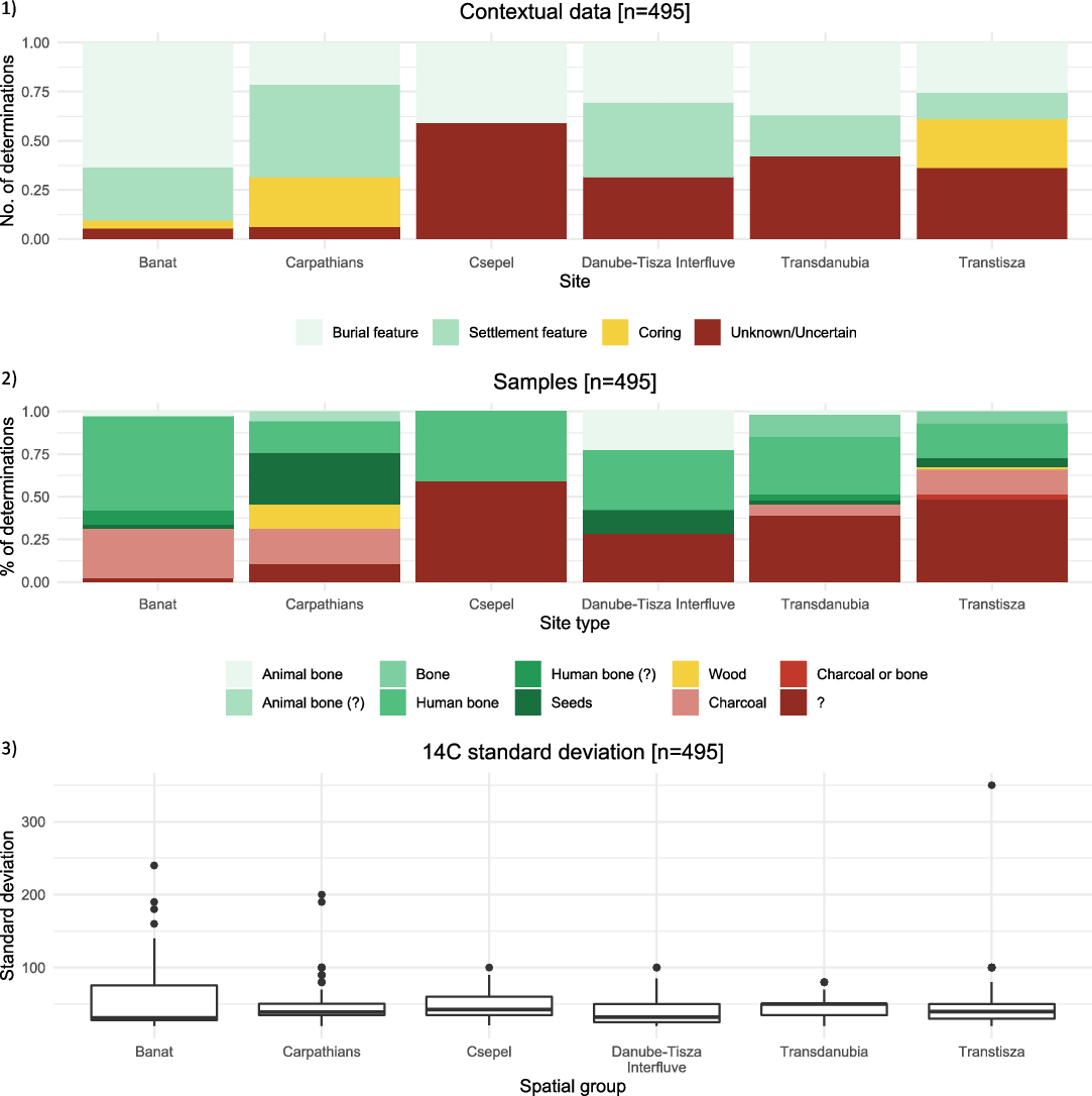
Figure 2 Evaluation of the radiocarbon determinations: (1) contextual information, (2) samples used for dating, (3) standard deviation of the reported 14C dates.
Chronological sequences for specific regions were based on different proxies, with burial data representing the majority of the available determinations for the Banat group (63.5%, n=47). Settlement-derived data was found prevalent for the Carpathians (47.2%, n=42) and the Danube-Tisza Interfluve (36%, n=32). The remaining groups were generally characterized by the highest proportion of datings from unknown or uncertain contexts, with the largest proportion found in the Csepel group (59.1%, n=13), followed by Transdanubia (42.1%, n=40), Transtisza (36.2%, n=46), and the Danube-Tisza Interfluve (36.0%, n=32).
Sample Type
Conclusive sample type information was provided for approximately 66,2% (n=328) of the collected samples (Figure 2.2). Ca. 3.8% (n=16) of samples were ambiguous in terms of their identification and were classified as possible animal (n=5) or human bone (n=11); in 3 cases the reported sample was classified either as charcoal or bone.
The sample type information was reported for at least 75% of the cases in only 2 groups (Banat [n=66], Carpathians [n=74]; cf. Figure 2.2). In the remaining groups, the defined sample information tended to vary from 70.7% (Danube-Tisza Interfluve [n=63]) to 40.9% (Csepel [n=9]).
Human bones represent the largest group of materials used for 14C dating (n=155), followed by unknown materials (n=148) and charcoal (n=65). This is specifically a problem for the dating of settlements, where samples of unknown materials or charcoal represent the majority of the available determinations. Without proper species identification and well-identified contexts or architectural structures, charcoal samples can result in erroneous dating of archaeological contexts (Bird Reference Bird2013; Wright Reference Wright2017). Without the information on the event leading to the formation of charcoal used for dating, the interpretation of the result cannot be directly translated into formulation of a coherent statement regarding the dated context. This is especially challenging for tell contexts, where the re-deposition of waste and sediment is directly responsible for site-formation processes (Miller Rosen Reference Miller Rosen1986; Rosenstock Reference Rosenstock2009; Sørensen and Vicze Reference Sørensen and Vicze2013).
Standard Deviation
The distribution of standard deviations reported for radiocarbon measurements was analyzed for all available samples (Figure 2.3). The interquartile range of standard deviations is 30 to 50 years. When the data was classified according to spatial groups, similar median values were documented. These ranges represent different resolutions from a regional perspective with the highest resolution observed for the Banat (31), Danube-Tisza Interfluve (32), and Carpathians (38) groups. The Transtisza (40), Csepel (42.5), and Transdanubia (50) groups were characterized by a higher median. In nearly all cases outliers were observed. In the majority of cases, high standard deviation of radiocarbon determinations is related to the first wave of 14C dating in the Carpathian Basin; high-resolution dating had not become prevalent until the second decade of the 21st century (Figure 3).

Figure 3 Radiocarbon dating in time and the changing accuracy of the radiocarbon determinations.
Selection of Radiocarbon Datings
Based on the evaluation of the existing determinations it is possible to state that while site-based dates are available, the contextual information on the dated samples remains problematic, and the types of samples used for radiocarbon determinations were often unreported or collected from insufficiently described materials. While the standard deviation of the samples has been improved in the recent years by the availability of AMS-dating, the large number of pre-AMS dates affects the possibility of generating high-resolution models. The stated issues are related to the relatively large presence of legacy data linked to the early stage of implementing radiocarbon dating in archaeological practice. In addition, in some instances much older radiocarbon dates were present, usually related to oldest possible contexts, which greatly exceeded the general dating of the Bronze Age in the Carpathian Basin (e.g., Bln 4375 from Jelšovce). Therefore, in order to increase the quality of the following investigation, a selection was implemented and following groups of datings were removed from further analysis:
-
(1) radiocarbon dates without contextual information,
-
(2) determinations without information on the collected samples or originating from materials of unknown provenance,
-
(3) determinations with the standard deviation above 50, and
-
(4) calibrated radiocarbon samples older than 3000 BC.
As a result of the selection, the initial dataset was reduced to 257 dates. The distribution of dates across different groups became more similar, apart from the Csepel group (Figure 4). The initial number of sites was reduced to 39, representing ca. 43% of the original dataset. Lastly, the distribution of site types under consideration changed, leading to the prevalence of determinations originating from cemeteries (n=150) followed by settlements (n=107). Taking into account the initial quantification, where settlements represented the largest number of determination (n=311), the implemented selection reveals the problems of radiocarbon dating of settlement contexts in the Carpathian Basin: currently only ca. 34% of the available, settlement-derived dates are sufficient for high-quality determinations. The abundance of legacy data, while providing substantial information on the dating of particular sites, has to be considered as problematic for high-resolution investigations.

Figure 4 Selected radiocarbon determinations per spatial group.
The selected dataset was modeled using KDE_Plot (Bronk Ramsey Reference Bronk Ramsey2017) in Oxcal 4.4.3 (Bronk Ramsey Reference Bronk Ramsey2009) using the IntCal20 calibration curve (Reimer et al. Reference Reimer, Austin, Bard, Bayliss, Blackwell, Bronk Ramsey, Butzin, Cheng, Edwards, Friedrich, Grootes, Guilderson, Hajdas, Heaton, Hogg, Hughen, Kromer, Manning, Muscheler, Palmer, Pearson, van der Plicht, Reimer, Richards, Scott, Southon, Turney, Wacker, Adolphi, Büntgen, Capano, Fahrni, Fogtmann-Schulz, Friedrich, Köhler, Kudsk, Miyake, Olsen, Reinig, Sakamoto, Sookdeo and Talamo2020). The function KDE_Plot is used to summarize large datasets of radiocarbon and investigate the density of probability distribution, while removing the noise from the calibration curve (Bronk Ramsey Reference Bronk Ramsey2017). In addition, the use of KDE plots allows consideration of realistic uncertainties in the temporal distribution of samples, therefore allowing evaluation whether the distinguished regions were characterized by similar probability distribution; this provides the means to consider whether the chronological sequence in the region suggests the contemporaneous emergence of large settlements and cemeteries (Bronk Ramsey Reference Bronk Ramsey2017). Assuming that the KDE plots can be used to estimate the chronological position of human activities responsible for the formation of these dated samples, the KDE plots allow investigating the probability distribution of the activities taking place between the Early and Middle Bronze Age occupation in the Carpathian Basin.
Since in the majority of cases there is insufficient contextual data to group observations based on prior information, the emphasis is made on exploratory investigation of whether regional trajectories indicate the contemporaneity of human activity in the entire macroregion. Recently, the approach has been successfully and similarly used to compare the shift in burial practices in Central Europe (Brunner et al. Reference Brunner, von Felten, Hinz and Hafner2021), as well as trace the spread of millet throughout Bronze Age Europe (Filipović et al. Reference Filipović, Meadows, Corso, Kirleis, Alsleben, Akeret, Bittmann, Bosi, Ciută, Dreslerová, Effenberger, Gyulai, Heiss, Hellmund, Jahns, Jakobitsch and Kapcia2020).
RESULTS
Based on the available dataset the emergence of Bronze Age contexts in the Carpathian Basin can be positioned ca. 2600 cal BC, with an increasing number of radiocarbon-dated contexts after ca. 2200 cal BC (Figure 5). The curve developed for the entire Carpathian Basin indicates that the majority of Bronze Age contexts fall between 2200 and 1300 cal BC. The peak of probability distribution is found at ca. 1850 cal BC, marking the decreasing probability of radiocarbon dating until ca. 1600 cal BC. Afterwards the probability distribution continues to decrease until ca. 1100 cal BC.

Figure 5 Early and Middle Bronze Age chronology of the Carpathian Basin: macroregional and regional perspectives (Supplementary Material 3).
The Banat group is characterized by a relatively constrained probability distribution with the earliest contexts dating back to ca. 2200 cal BC, followed by a steady increase until a peak at ca. 1700 cal BC, followed by a final decline at ca. 1350 cal BC. Based on the analysis, the dating of Bronze Age contexts in the region points towards a later onset of human activities than in the entire macro-region.
The Carpathians group is characterized by continuous dating of contexts related to the third millennium BC, followed by a peak at 1700 cal BC and a final decline at ca. 1200 cal BC. It seems probable to assume that the first peak occurred ca. 2100/2000 cal BC, and the current probability distribution represents the unequal sampling of dates from Bronze Age contexts.
The probability distribution of the Csepel group starts at ca. 2600 cal BC, with the peak at ca. 2350 cal BC, and a decline at ca. 2000 cal BC. The dating indicates that human activities in the region were constrained with no post-2000 cal BC occupation of the entire area.
The Danube-Tisza Interfluve group is characterized by an increase of probability distribution ca. 2500 cal BC, a plateau between 1800 and 1500 cal BC, and a decline ca. 900 cal BC. The current dating suggests that the Bronze Age dating of the region focuses on the Middle Bronze Age period with evidence pointing towards long-term human presence throughout the entire second millennium BC.
The Transdanubia group is characterized by the earliest dating at 2650 cal BC, followed by a first peak at ca. 2350 BC, a decline until ca. 2150 cal BC, second peak at 1900 cal BC, and a final decrease at ca. 1400 cal BC. As such it represents a chronological trajectory distinct from the macrocregional curve, both in terms of the onset and the final stage of Bronze Age contexts in the region.
The Transtisza group is characterized by an increase from ca. 2500 cal BC, first peak at ca. 2350 cal BC, first decline at 2150 cal BC, second peak at 1850 cal BC, second decline at 1600 cal BC, third peak at ca. 1450 cal BC, and the final decline at 1100 cal BC. The probability distribution contrasts with the macroregional curve, since it is characterized by three instances of increasing probability of dating human activity.
Since the analyzed regional plots represent an aggregation of dates originating from different contexts, i.e., burials and settlements, determining the temporal position of different site types can help understand long-term habitation trends. Currently, the analyzed sample is characterized by the prevalence of burial data. This sampling bias affects the possibility of comparing regional chronologies in terms of the similarities between burial and settlement trajectories: the chronological record of only 3 groups comprises of dates originating from burials and settlements (Banat, Western Carpathians, Western Transdanubia). In some instances, the dated human remains originate from settlements, e.g., Kakucs-Balla domb (Danube-Tisza Interfluve), although it is not entirely clear whether new cultural practices became incorporated as part of habitation practices, or the settlement was entirely repurposed as a burial ground (Jaeger and Kulcsár Reference Jaeger and Kulcsár2013). As such, the chronologies of the two types of the radiocarbon contexts will be evaluated as a whole in order to answer the question whether the temporal differences observed across the macroregional and regional groups can be linked to the different depositional processes.
Despite of the equalization of the Middle Bronze Age with the emergence of tell settlements, the first half of the second millennium BC was characterized by a diversity of habitation forms (Figure 6). The probability distribution of cemeteries, flat settlements, and multi-layered settlements overlaps until 2200 cal BC and the presence of flat settlements terminates ca. 1400 cal BC. The density of radiocarbon determinations from multi-layered settlements reaches its peak ca. 1800 cal BC and declines ca. 1400 cal BC, similarly to the flat settlements. Between ca. 1800 and 1500 cal BC fortified settlements start to be documented. This category is generally applied for sites in Slovakia and southern Poland, which are characterized by material culture similar to Middle Bronze Age pottery of the Füzesabony-Otomani style (Jaeger Reference Jaeger2016; Gancarski and Madej Reference Gancarski and Madej2019). These sites are not treated as tells since in majority of cases only a single occupation layer was documented (Jaeger Reference Jaeger2016). Finally, the Early and Middle Bronze Age funerary contexts point towards continued human presence from the second half of the third millennium cal BC until the end of the second millennium cal BC. The increasing density of radiocarbon dates in the burial record corresponds to the increasing diversity of settlement types ca. 2200 cal BC, when the first multi-layered settlements start to be documented.

Figure 6 Settlement types and cemeteries in the Early and Middle Bronze Age Carpathian Basin: a radiocarbon model (Supplementary Material 4).
The final stage of the analysis was determining the chronological position of specific sites within the context of the regional groups to determine whether the emergence of settlements was contemporary over the entire duration of the Early and Middle Bronze Age, and how was it related to the establishment of cemeteries. For the purpose of the analysis all sites with less than 2 radiocarbon measurements were removed from the analysis to ensure the representability of the KDE plots. This reduced the number of available sites to 26, and total number of available radiocarbon dates to 245.
The Banat group comprised of three cemeteries and two settlements (Figure 7). The oldest flat settlement (Foeni Gaz) overlaps with the early stage of the multi-layered settlement (Rabe-Anka Siget), as well as the onset of three cemeteries. The probability distribution of the multi-layered settlement overlaps with all remaining cemeteries, with the Ostojićevo-Stari Vinogradi showing potential duration past the abandonment of the settlement.

Figure 7 KDE plots for each of the archaeological sites within regional groups (Supplementary Material 5).
The Carpathians group comprised of two cemeteries and three settlements. The multi-layered settlement of Vráble-Fidvár covers the entire timespan of the Early and Middle Bronze Age, where the transition between the flat and multi-layered settlement occurred ca. 2200 cal BC (Schlütz and Bittmann Reference Schlütz and Bittmann2016). The cemeteries of Jelšovce and Nižna Myšl’a overlap with the probability distribution of Vráble-Fidvár, and partly with the two fortified settlements which emerged later (Brzezówka 10, Maszkowice).
The Csepel group represents the earliest context for human burials, prior to the establishment of any multi-layered settlements. In addition, no such forms of occupation are known from the island (Kulcsár Reference Kulcsár2011, Reference Kulcsár2013).
The Danube-Tisza Interfluve group comprised of four settlements and two cemeteries. The dated contexts originated from multi-layered phases of these settlements, indicating the overlap of this form of occupation with the earliest cemetery (Boconád-Alatka-puszta and Kiskundrozsma-Hosszúhat halom). The later settlements of Kakucs-Balla-domb, Kakucs-Turján, and Füzesabony-Öregdomb were all multi-layered settlements, which partly overlap. The cemetery of Tápé-Széntéglaégető only partly overlaps with the tail of the probability distribution of Kakucs-Balla-domb.
The Transdanubia group comprised of five cemeteries and a single settlement. The cemetery of Bonyhád-Biogas factory was used throughout the entire Early and Middle Bronze Age. The remaining cemeteries have two probability distributions: from ca. 2500 cal BC to approx. 1500 cal BC, and ca. 2100 cal to 1500 cal BC. The settlement of Vörs-Máriaaszonysziget corresponds to the second one.
The Transtisza group comprised of a single cemetery and two settlements. While the cemetery of Békés was used already in the mid-third millennium cal BC, the majority of burials originate from the second half of the second millennium BC and continue past the 1500 cal BC threshold. The settlement on the other hand show the presence of long and short-term occupation, where the probability distribution of Semlac-Livada lui Onea points towards continued use from mid-third millennium cal BC to 1500 cal BC. Emőd-Nagyhalom was used from 2000 to approx. 1600 cal BC.
DISCUSSION
The analysis indicates that while tell settlements can be generally positioned between 2200–1250 cal BC, their emergence was not uniform across all regional groups (Figure 8.1). This corresponds to the increasing formation of cemeteries in the region. In some groups (Carpathians, Transdanubia, Transtisza), this earliest phase of occupation is only characterized by burial contexts.

Figure 8 Radiocarbon-based model of spatial dynamics in the Carpathian Basin between 2600 and 1200 cal BC.
While onset of tells ca. 2200 cal BC marks the chronological thresholds for the majority of regional groups (Carpathians, Danube-Tisza Interfluve and Transtisza), the increasing number of settlements corresponds to ca. 1950 cal BC (Banat, Danube-Tisza Interfluve, Transtisza; Figure 8.2). The number of cemeteries increases regionally, although not all groups are immediately characterized by the establishment of burial grounds (Danube-Tisza-Interfluve). Although flat settlements were documented as well, even in areas where tell settlements become widespread, the current dating suggests that this habitation form became restricted to Transdanubia between 1850–1500 cal BC (Figure 8.3). This region specifically is characterized by a large number of contemporarily used cemeteries. The radiocarbon dataset for the majority of groups terminates ca. 1500 cal BC, with the majority of dating restricted to the Banat group (Figure 8.4).
The investigation shows that while there are substantial grounds to consider tells as a largely contemporary phenomenon, the formation of settlements was characterized by two different emergence trajectories. The initial stage was characterized by long-term occupation, which would result in the emergence of tell settlements (Carpathians, Danube-Tisza Interfluve, Transtisza). It is plausible that the maintenance of these eventually long-term settlements would establish a certain practice related to spatial management. After this initial long-term process, tell settlements would become more widespread, and generally were characterized by a shorter occupation. Similar trajectory is visible for the emergence of cemeteries, which were initially established in the mid-third millennium BC, followed by a secondary rise when the number of tell settlements increases. The study shows that there were similar regional trends of how people created their living environment, undergoing intensification due to a process of secondary aggregation in previously unoccupied areas. The challenge lies in determining how these findings fit into large, well-known sites which as of yet have not been subject to radiocarbon dating or could not be implemented in this model due to insufficient contextual data, e.g., Újhartyán-Vatya, Százhalombatta-Földvár, or Pecica “Şanţul Mare”. It is probable that the emergence of chronologically early settlements was more widespread, but considering the current radiocarbon record of Early and Middle Bronze Age sites and especially the impact of legacy data, this points towards a viable hypothesis rather than a solution to the problem.
Two outliers were identified: the Csepel and Transdanubia groups, where no tell-based form of occupation was discovered. In the first case, a limited but rich dataset of a flat settlement and adjacent cemetery is known from excavations, although their exact temporal relationship cannot be determined using the proposed methodology (Patay Reference Patay2013; Endrődi and Reményi Reference Endrődi and Reményi2016). Although the absence of Early and Middle Bronze Age tell settlements was observed early-on (Kiss Reference Kiss2012), the continued use of the cemetery in Bonyhád-Biogas factory would suggests that different means of establishing permanent spaces was taking place (Sørensen and Rebay-Salisbury Reference Sørensen and Rebay-Salisbury2008; Hajdu et al. Reference Hajdu, György-Toronyi, Pap, Rosendahl and Szabó2016).
From the standpoint of on-going discussion regarding the collapse scenario explaining why a fairly large number of settlements were no longer occupied past ca. 1500 cal BC, no determinate answer can be provided (Fischl et al. Reference Fischl, Kiss, Kulcsár and Szeverényi2013; Vicze et al. Reference Vicze, Poroszlai and Sümegi2013; Duffy et al. Reference Duffy, Parditka, Giblin and Paja2019). The existing models indicate that the perspective of the so-called abandonment process was influenced by the sampling employed in different dating programs. The contextual data related to the final stages of occupation is scarce in terms of providing evidence of crises, conflict, and/or a dramatic turn of events which would contrast with the preceding phases (David Reference David1998). This should be expected considering the long history of modern agriculture, where the position of tells overlaps with the most intensively used soils for agriculture (Staniuk Reference Staniuk2020). Combined with the progressing erosion of elevated settlements, the problem of interpreting the final habitation stages requires the reconsideration of the research methodology and the selection of suitable datasets. This problem has already been documented for the site of Vráble-Fidvár, where settlement layers documented in 1967 were barely visible in 2009 (Bátora et al. Reference Bátora, Behrens, Gresky, Ivanova, Rassmann, Tóth and Winkelmann2012; Nowaczinski et al. Reference Nowaczinski, Schukraft, Rassmann, Hecht, Texier, Eitel and Bubenzer2013).
While the discontinuity of settlement use is supported by radiocarbon dating, currently the only potential correlational link to this process is the deposition of volcanic material leading to a climatic change ca. 1630 cal BC (Demény et al. Reference Demény, Kern, Czuppon, Németh, Schöll-Barna, Siklósy, Leél-Őssy, Cook, Serlegi, Bajnóczi, Sümegi, Király, Kiss, Kulcsár and Bondár2019). While this points towards to a potential hazard, conducted investigation would suggest that occupation of settlements and the use of cemeteries continued for another hundred years. As such, another question remains whether decreasing temperature in the Carpathian Basin was immediately a challenge for the inhabitants of different sites, or whether it became a hazard only after a few generations.
CONCLUSION
The proposed model shows that the Early and Middle Bronze Age in the Carpathian Basin was characterized by the emergence of the first settlements ca. 2200 cal BC. This was accompanied by the emergence of the first cemeteries. This first stage of occupation would eventually result in the formation long-term settlements. Secondary occupation occurred ca. 1950 cal BC, again accompanied by the emergence of new cemeteries. The dated contexts suggest that ca. 1500 cal BC the majority of settlements were abandoned, and the only continued occupation could be documented in the Banat region. Despite the occurrence of a climatic change ca. 1600 cal BC, sites continued to be used for approx. 100 years before being abandoned.
ACKNOWLEDGMENTS
This work was supported by the PhD position “Tradition and Practice – Study on Pottery, Chronology and Social Dynamics of the Hungarian Bronze Age” (GSC608) at the Graduate School “Human Development in Landscapes” at the University of Kiel. I would like to thank John Meadows (Kiel) for his comments on the early draft of this paper, which helped me restructure my argument. Additional thanks go to Peter Barta (Bratislava) for access to his published work. I would also like to thank Sarah Martini (New Haven) for proof-reading the article and her comments. Lastly, I would like to thank both reviewers for their comments and suggestions on how to improve the paper.
Supplementary material
To view supplementary material for this article, please visit https://doi.org/10.1017/RDC.2021.83


 Open access