1. INTRODUCTION
The Decca Navigator System was very unusual among radio-navigation systems in that the entire system was championed and marketed by a commercial company. That it was successful is not in doubt; at its peak it was in use by over 30,000 vessels and something like 8000 aircraft. Every other major radio navaid has been the product of a military initiative that was eventually released for general users although sometimes still controlled by the military – the Global Positioning System (GPS) is a good example. That meant that all the costs of design, development and continued operation were met in one way or another by the military and as a result commercial companies only had to market user equipment. Although Decca was first used in a military context, design and development was always in the hands of a private company that managed without government subsidies or assistance. It is unlikely that a radio navaid will ever again be funded from a single private source and in that respect Decca will stand alone for all time. At one time Decca even took on the United States Government in defence of its technology – and won (Decca Ltd. v. United States, 1976). This paper summarises how the Decca Navigator came about up to the point when it became fully established as an accepted marine navaid.
2. THE TECHNICAL BACKGROUND
The historical emphasis on radio has generally been on its use as a communication medium but it has numerous applications for finding position, the basis of all navigation. As early as 1888 Hertz observed that the circular pieces of wire he used for aerials worked better when they were parallel to each other, indicating directional effects. Then, in 1900 Marconi applied for a patent on a navigational device comprising a very long piece of wire strung out in the direction that maximum transmission or reception was required. To work it had to be so long – several kilometres – it was impracticable on a ship and anyway its “beam” was so broad it was navigationally not of much practical use. In 1903 John Stone (USA) devised a system of directional reception for ships that required the alignment of two vertical aerials with a distant transmitter. It did not find favour because the entire ship had to be turned, wasting fuel and time. These early efforts required huge aerials because radio-frequency amplification had not arrived and the only way of collecting sufficient electrical energy to work with was by using lots of wire.
In 1914 the First World War (WW1) resulted in the development of the amplifying radio valve, in turn leading to more sensitive receivers and stable narrow-band high power transmitters. The first serious use of radio for navigation of a moving vessel occurred when a German naval airship attacking the UK in April 1915 used positions provided by a direction-finding service operated by the German Navy from Cuxhaven and Borkum (Trenkle, Reference Trenkle1987). Direction-finding was the only practical way of using radio in those days but it had a major disadvantage in that as distance from the direction-finder increased spatial accuracy decreased – a 1° error represents 1 km on the ground at 60 km and 10 km at 600 km. A much better method of using radio is to measure distance, any error staying constant at all distances. The speed of travel of radiowaves is known – 300,000 km/sec – so if an accuracy of say 30 m is desired then a method of measuring time to a tenth of a microsecond is required. The first attempts at measuring range by radio were made by Fessenden (Canada/USA) who in 1904 patented a system using distance measurements which were to be obtained by measuring received signal strength (Fessenden, Reference Fessenden1904). He reasoned that since the weakening of radio signals as one drew away from a transmitter followed an exact mathematical rule then received signal strength could be used to measure distance. Unfortunately there are many complicating factors affecting signal strength other than sheer distance, such as the characteristics of the receiver and size of aerial that make this method highly unreliable. In any case signal strength follows a square law (twice as far is a quarter signal strength) so that at other than short distances a small change in strength represents quite a large distance.
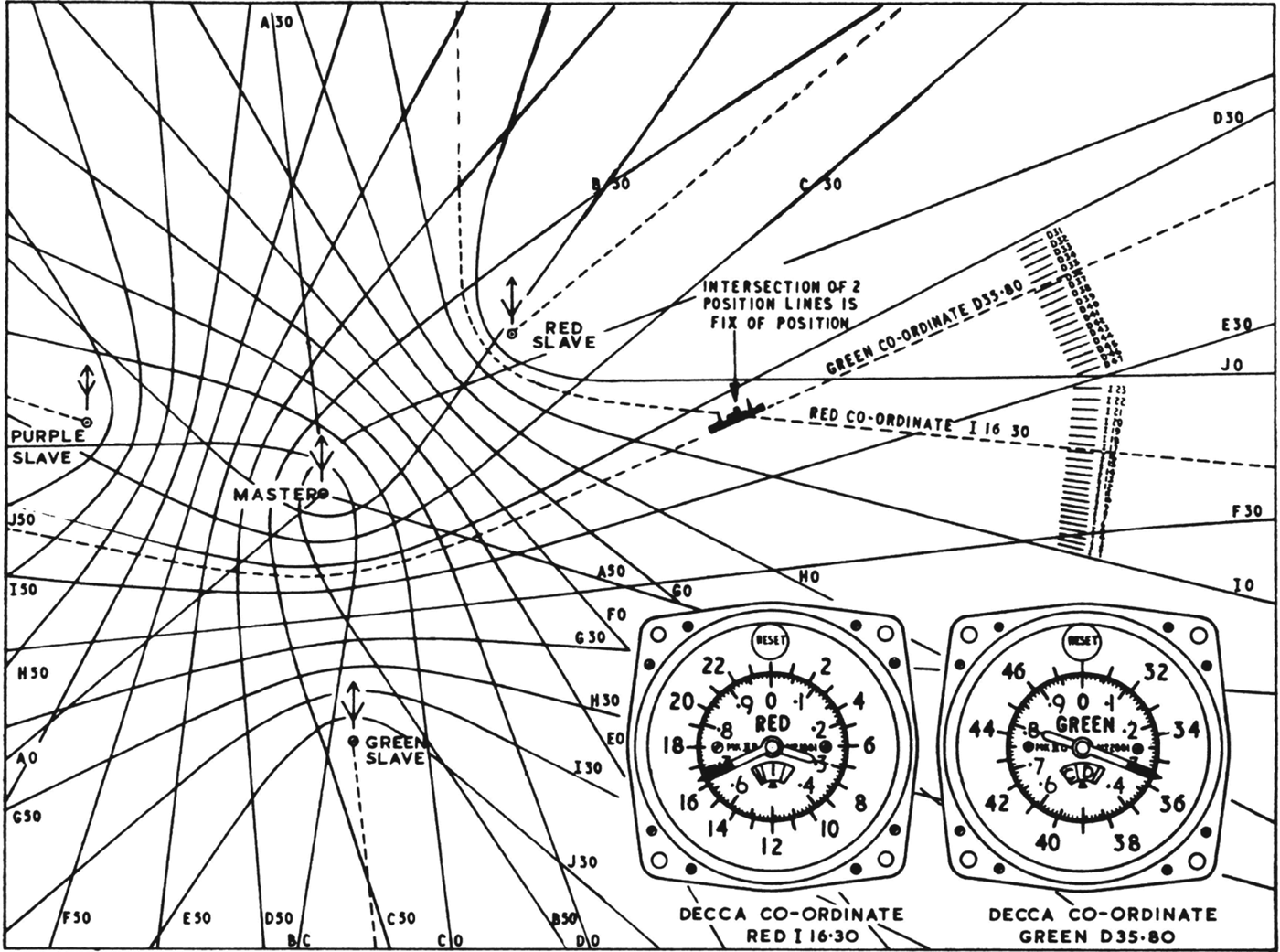
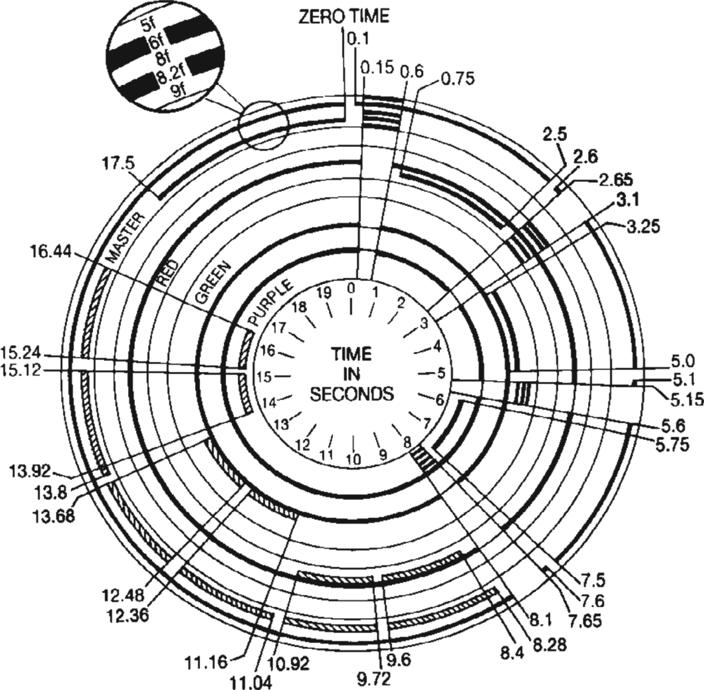
Even assuming that some sort of precise time marker could be introduced into a radio signal the fundamental difficulty still remained of obtaining very accurate timing. Holding the timing stability of both transmitters and receivers to tenths of a microsecond for long periods was well beyond the state of the art until the 1940s. However, as early as the 1920s it was realised that although absolute timing to this accuracy could not be achieved the difference in reception times between two transmitters might be measured accurately as long as they transmitted synchronously. For instance, one transmitter would act as a “master” station and transmit continuously some sort of timing signal while a second “listened” to it and transmitted only when it recognised the synchronising signal. In this way the second signal would be received after the first one and follow it through any ups and downs in timing, permitting the time lapse between the two to be measured with something approaching the right accuracy. After plotting the positions of the transmitters on a chart these time differences, which were hyperbolic in form, could also be plotted and translated visually into geographical position. The multitude of systems later developed using this principle were classified under the generic term “Hyperbolic Systems” (Figure 1).

Figure 1. The Decca hyperbolic lattice and how the Decometers presented their readings.
Probably the first use of this hyperbolic principle was not by radio at all but by using the sound waves generated by guns firing in WW1 bombardments. Microphones were located at known points and the time-of-arrival of the sound of the guns firing was used to find their position (Powell, Reference Powell1981).
3. EARLY WORK
What eventually became the “Decca Navigator” was conceived by an American consulting engineer, W. J. “Bill” O'Brien, who in 1937 was asked by the Douglas Aircraft Corporation in the USA, who were designing their new and revolutionary DC-2/3 transport aircraft, whether there was any radio method that might measure, much more accurately than by contemporary theodolite-based methods, the ground speed of an aircraft (Obituary notice, William Joseph O'Brien, 1984). O'Brien's first idea was to use the Doppler effect, but sufficient transmitter stability did not seem likely with the technology of the day, so he then came to the idea of using two ground transmitters, one serving as reference for the other if their signals could be locked together, as described above. Failing the appearance of pulse methods, which at the time were shrouded in secrecy, the only available method of doing this was to compare the phase of the received signals. That could only be done when both signals were on the same frequency and complications arose when attempting to extend the idea to several stations simultaneously. O'Brien concluded that it would be necessary to use stations transmitting on different but harmonically-related frequencies that could be brought to a common frequency for phase comparison at the receiver. The requirement to keep all the “slave” stations in synchronism with the “Master” could be met by incorporating a monitor station into the system that tracked all stations and used any variations to drive the phase at the offending station back into synchronism and thus keep the stations aligned. This in itself required the monitor receiver to be of highly stable design so as not to introduce its own errors, and it was in the design of this receiver that O'Brien probably made his major contribution, the navigation receivers being simplified versions of the monitor receiver. It was a neat solution that allowed several transmitters to radiate simultaneously and continuously although with the penalty of complicating receiver design. Another advantage was that the transmissions were plain un-modulated radio-frequency carrier waves which could be detected by receivers of very narrow bandwidth, thus eliminating any need for high transmitter powers.
O'Brien offered his solution to Douglas, who turned it down so he took it to the appropriate US military and civil aviation authorities, who also did not consider it practical. Being temporarily in poor health, O'Brien dropped the matter until the outbreak of war in 1939 when, wishing to help the British war effort he sent his ideas to a friend, H. F. Schwarz, an American who had been working in London for the Decca Record Company for some years and had now become its Chief Engineer (Radio).
4. SECOND WORLD WAR DEVELOPMENT
Schwarz obtained the support of Decca's Managing Director, Edward Lewis, and in October 1939 sent a letter to Sir Henry Tizard at the Air Ministry outlining their ideas. Tizard in turn asked Robert Watson-Watt, Superintendent of the Radio Department of the National Physical Laboratory, for his opinion. He rejected it as being potentially too subject to jamming and other interference but after the Second World War (WW2) he admitted he had been mistaken, although to be fair he was preoccupied with work on the British radar chains and the GEE system at the time (Watson-Watt, Reference Watson-Watt1957). Schwarz did not lose faith in the system and submitted a second Decca paper, dated 2 May 1941, to the Air Ministry proposing a “Directional Control System” for aircraft landing and guidance. He was somewhat disappointed to find it evoked no response but in the official United Kingdom (UK) history of the air war it is stated that the Air Ministry/Royal Air Force (RAF) were receiving “hundreds” of wild ideas for air navigation at this time which may explain why! Schwarz then turned his attention to the Navy and managed to get an interview with the Department for Scientific Research (DSR) at the Admiralty in September 1941. This had better results and in October 1941 he was asked to prepare a proposal for a formal trial, but following it there was again an unexplained long silence except for a letter in March 1942 saying that there had been “no decision as yet” regarding a trial. In the meantime he decided to organise his own demonstration but due to the wartime restrictions could not obtain the facilities he needed in the UK. It was much easier in the not-at-war USA so as US citizens he and O'Brien were able to return there to build and test a prototype system in California using a master transmitting at 300 KHz and a slave at 600 kHz. Phase comparison was made at 1200 kHz and the resultant accuracy demonstrated in a car which amply proved the basic viability of the system. Possibly as a result of the September 1941 interview with DSR a British observer (Air Commodore Cedric Bell, oddly enough from the RAF, not Royal Navy, mission in Washington) attended the demonstrations but the general response was still no more than lukewarm (O'Brien, Reference O'Brien1947). Somewhat to the annoyance of Schwarz, it was not followed by any further action by the Air Ministry, but it was disclosed after the War that it was by then fully occupied with work on GEE and H2S which it thought were more appropriate for aircraft and were taking all its resources. Decca, of course, had no knowledge of this.
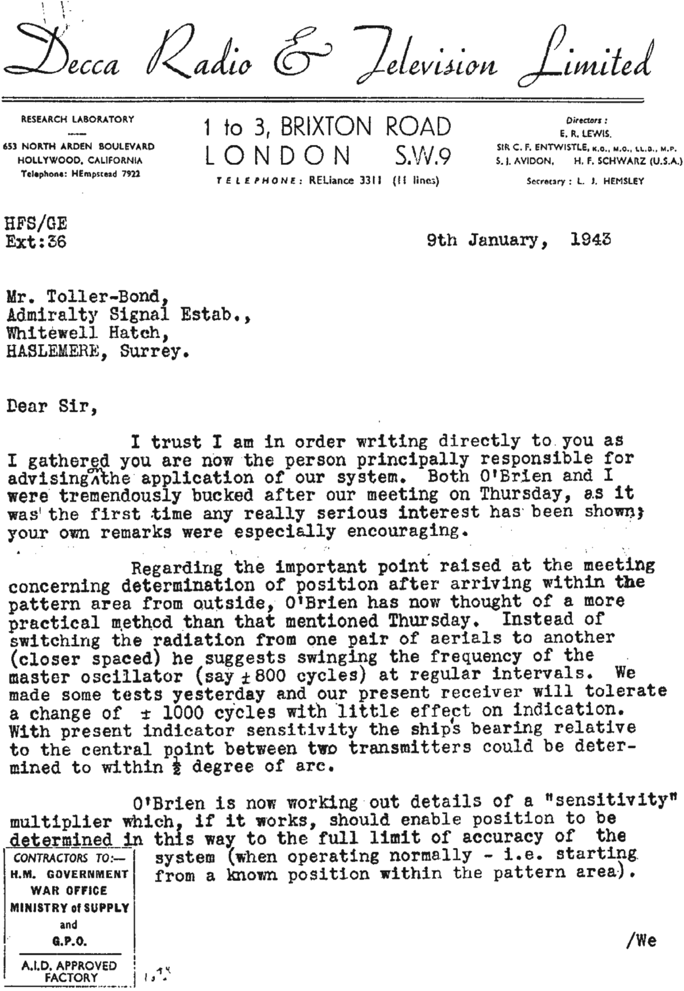
The Naval interest, however, grew because the low radio frequencies used by Decca permitted sea-level use at considerable ranges, unlike GEE which being VHF was line-of-sight only, and at long last, in September 1942, the Navy decided to give the invention a proper trial. A specialist officer, Derek Toller-Bond, was appointed to the Admiralty Signals Establishment (ASE) to oversee it and things started to move along. It was then that Decca first made official contact with A.S.E. Haslemere (Figure 2), starting a collaboration that was to bear much fruit in the wartime development of the system and in later years.
Figure 2. Contact letter to ASE from Decca.
After some delay, connected with the allocation of frequencies, plans for a seagoing demonstration were put in hand. This encouraged Schwarz to ask Bill O'Brien to come over to the UK and join him and although not fully recovered from his illness, O'Brien did so in July 1942, never returning to the USA.
4.1. Admiralty Trials, 1942
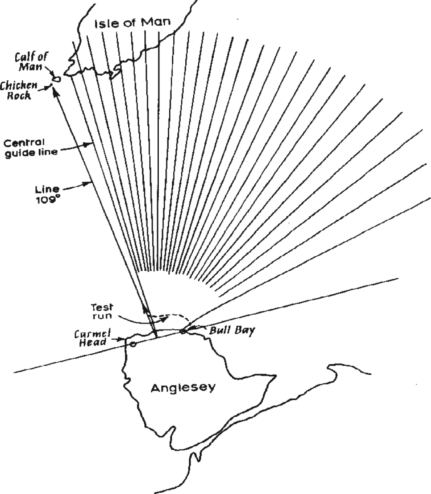
For the first Admiralty trial it was decided that the system should be confined to a single pattern of position lines generated by a pair of stations, which were set up in Anglesey at Carmel Head and Bull Bay (Figure 3). The harmonic relationship used in the tests in the USA was retained, with the master at Carmel Head radiating 305 kHz and the slave 610 kHz, the comparison frequency being 1220 kHz. The transmitters were of an Admiralty transportable type delivering 12 kW into the antenna. The receiver read-out was a simple centre-zero meter driven by a “half” phase discriminator circuit which measured phase changes of up to ±90°, as opposed to the full discriminator later developed to drive a circular 360°-reading phasemeter (“Decometer”) through one revolution for one cycle of phase difference.
Figure 3. First experimental chain at Anglesey.
There being no “Decometers” at this time, the all-important cycle integration was to be performed by an observer visually keeping count of each crossing of the meter pointer through the zero position. For every whole cycle change in master/slave difference, the pointer would cross the zero mark first in one direction and then in the other, the crossings recurring at intervals of 180° of phase. Each such interval would correspond to a quarter-wavelength change of position along the baseline, since movement towards one of the stations along the baseline also entailed movement away from the other.
It was calculated that there would be a total of 206 zero crossings on a journey from one baseline extension to the other, and the pattern was drawn on this basis. One of the two experimental receivers was set up at Bull Bay to act as a monitor and the other, after preliminary runs in a car, was installed on the bridge of the Dutch trawler En Avante. A report by Decca Radio and Television Ltd. described what followed (quoted in O'Brien, Reference O'Brien1947).
“Several runs from the east side of Bull Bay were made at various distances from the coast, and the count of 206 lines checked. A run was then made on the central guideline to the Isle of Man, and the place at which this line cut the coast noted; the trawler was then turned west and speed cut very low in order to observe the accuracy of indication as zero points on the meter were crossed. As near as could be judged, a full scale deflection of the meter, i.e. from extreme starboard indication, to extreme port indication covered a space of about 80 feet, so that five small divisions on the meter (5% of full meter deflection) corresponded to 3 or 4 feet, which can be considered the practical limit of accuracy for the distances involved. (The distance from Anglesey to the Isle of Man is approximately 46 miles and the accuracy is a function of the ratio of this distance to the station separation.) The westward course was continued and crossover lines counted until Chicken Rock, which is an especially accurate landmark in that it consists of only a lighthouse protruding from the water, was reached. It was determined that Chicken Rock was on line 109 and this line was followed back to Anglesey.”
On the morning of the 16 September 1942, representatives of the Admiralty, Ministry of Aircraft Production, Ministry of Supply and Post Office were taken on board at Bull Bay for the demonstration run. Departing from the east of Bull Bay (on a line joining the two stations), lines on which the meter pointer crossed were counted until line 109 was reached, then the trawler was turned sharply to starboard and then guided entirely by the meter indication. (When the meter pointer was to the right, the boat was steered to starboard; to the left, to port, thus bringing the pointer back to zero or centre position.) This course was maintained until we were within approximately 3 miles of Chicken Rock when it was obvious that if the course were continued the trawler would strike the lighthouse. Certainly the deviation if it existed was so small that none could judge on which side it occurred.
An interesting sidelight on the usefulness of the instrument as a guide to navigation was provided by the Captain of the trawler, when one of the party suggested that it would be quicker to return by taking a diagonal course to Bull Bay than to follow one of the guide lines back to the coast of Anglesey and then go over to Bull Bay. The Captain immediately replied that he could steer so much more accurately by using our instrument that the latter method would be quicker.”
O'Brien recalled that the elderly En Avante was very slow, and as there was a cross tide during the approach to Chicken Rock her bows were pointing far off the target when it became visible. Sceptics in the party started speculating on the size, in terms of miles, of the eventual error. The skipper, however, was plotting regular fixes from horizontal sextant angles using selected landmarks on the receding shore; in due course he suddenly straightened up and gave O'Brien a thumbs-up.
After the Chicken Rock demonstration the development of the system continued with increasing pace at the Decca factory in Brixton and at ASE, and also in a flat in Dolphin Square, in south-west London, which Schwarz and O'Brien used as a private laboratory and pied-a-terre. In the course of further Naval trials, the signals were observed at long ranges at various points, including Dolphin Square, and it became apparent from the performance under night conditions that the frequency values so far used would not be satisfactory for a practical system. At 600 kHz, the groundwave attenuation was too high, resulting in severe shortening of the range when land intervened in the transmission path, and also in the onset of skywave interference at relatively short distances from the station. It also became questionable whether multiplication to a common frequency as high as 1220 kHz was desirable in view of the closely-spaced ambiguous position lines that resulted, and of the fact that signal/noise performance deteriorated as the frequency multiplication factor was increased.
This led to a revised frequency format being evolved in 1943 in the form 6f, 8f and 9f, where f is about 14 kHz, from which the frequencies transmitted by the master, ‘red’ and ‘green’ slave stations respectively would be derived. The two slaves could then combine with the master to create two intersecting hyperbolic patterns, by phase comparison at 24f and 18f. The patterns would form a position-fixing grid and would be depicted in distinctive colours on the charts (Figure 1). A third slave, necessary for all-round coverage, did not materialize until 1946–47 when the ‘purple’ transmission was added; initially this was to have been of frequency 7f, with phase comparison at 42f but a 5f carrier and 30f comparison frequency were adopted to reduce multiplication factors and avoid encroaching upon the band (100 kc/s) envisaged for a projected low-frequency version of Loran of which O'Brien was aware. The 5: 6: 8: 9 format for the transmitted frequencies remained in permanent use and the frequency band 70–130 kHz, within which it falls, later proved an inspired choice having regard to the various propagation factors involved.
4.2. Pre-D-Day trials
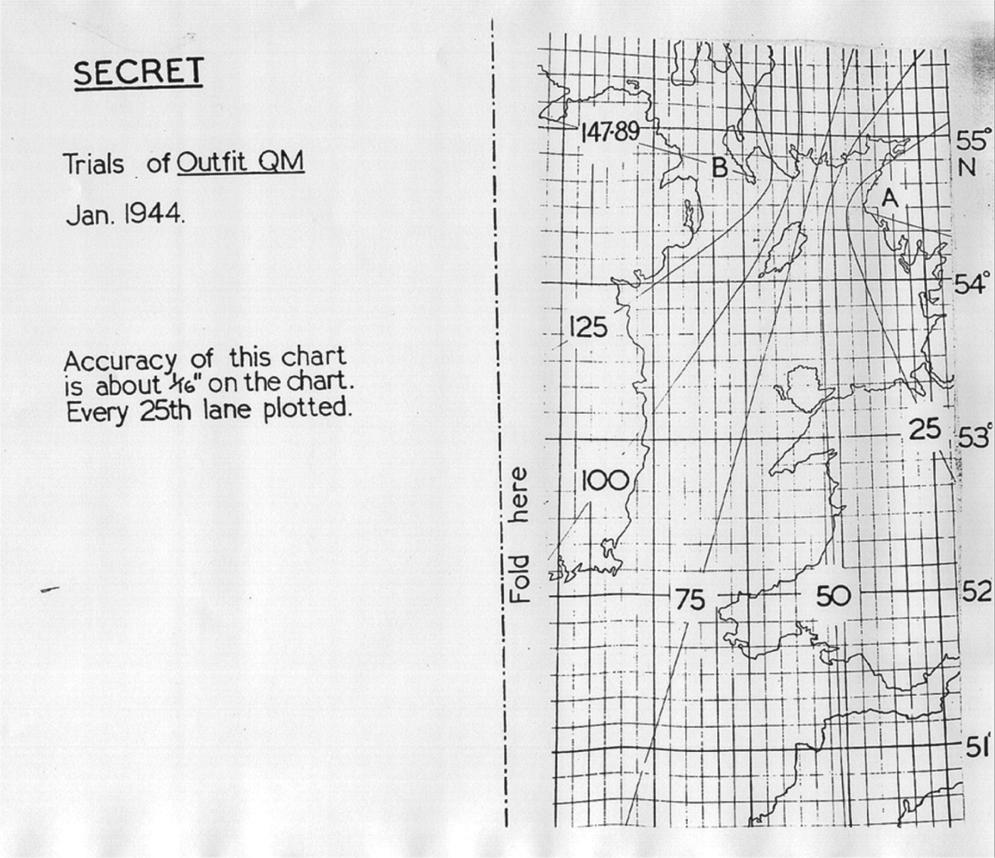
With the Allied invasion of Europe getting ever closer various trials of the Decca system were carried out, starting on 21st January 1944 with range and accuracy tests in the Northern Irish Sea (Figures 4 and 5).
Figure 4. Station layout for second trial.
Figure 5. Chart for second trial.
A single position-line pattern was again used, generated by stations at Drummore and at Calderton near St Bee's Head; the receiver being installed on board HMS Saltburn. Accuracy was satisfactory and the results suggested that a range of 200 miles should be feasible. Signals based on a master frequency of 6f (about 85 kHz) were transmitted for the first time on this trial. Competitive tests between QM, as the system was now code-named, and QH (GEE), in which the positions given by the two systems were checked against visual fixes, confirmed the greater sea-level range of QM as well as its higher accuracy.
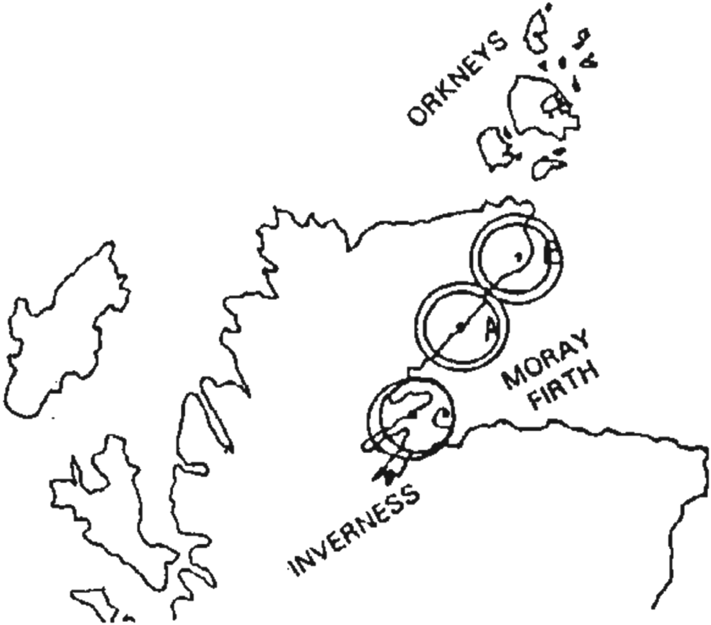
Following this trial a decision was taken to adopt QM for the critical mine-sweeping aspects of Operation Neptune (code name for the Naval element of the main operation Overlord). To confirm operational aspects, QM was used in a large-scale assault and landing exercise in the Moray Firth area, prototypes of six of the new receivers (QM1) being rushed out by 20 February, the date of the exercise. A three-station chain to give position-fixing (as opposed to a single line of position) was deployed along the northern shore of the Firth on baselines of about 45 miles (Figure 6).
Figure 6. Layout for third trial.
The results showed the capabilities of the system and also confirmed that navigating officers could quickly learn to operate the receivers; at least as important, the results bred confidence among those who would eventually navigate the leading vessels of the invasion assault forces.
4.3. Operation Neptune
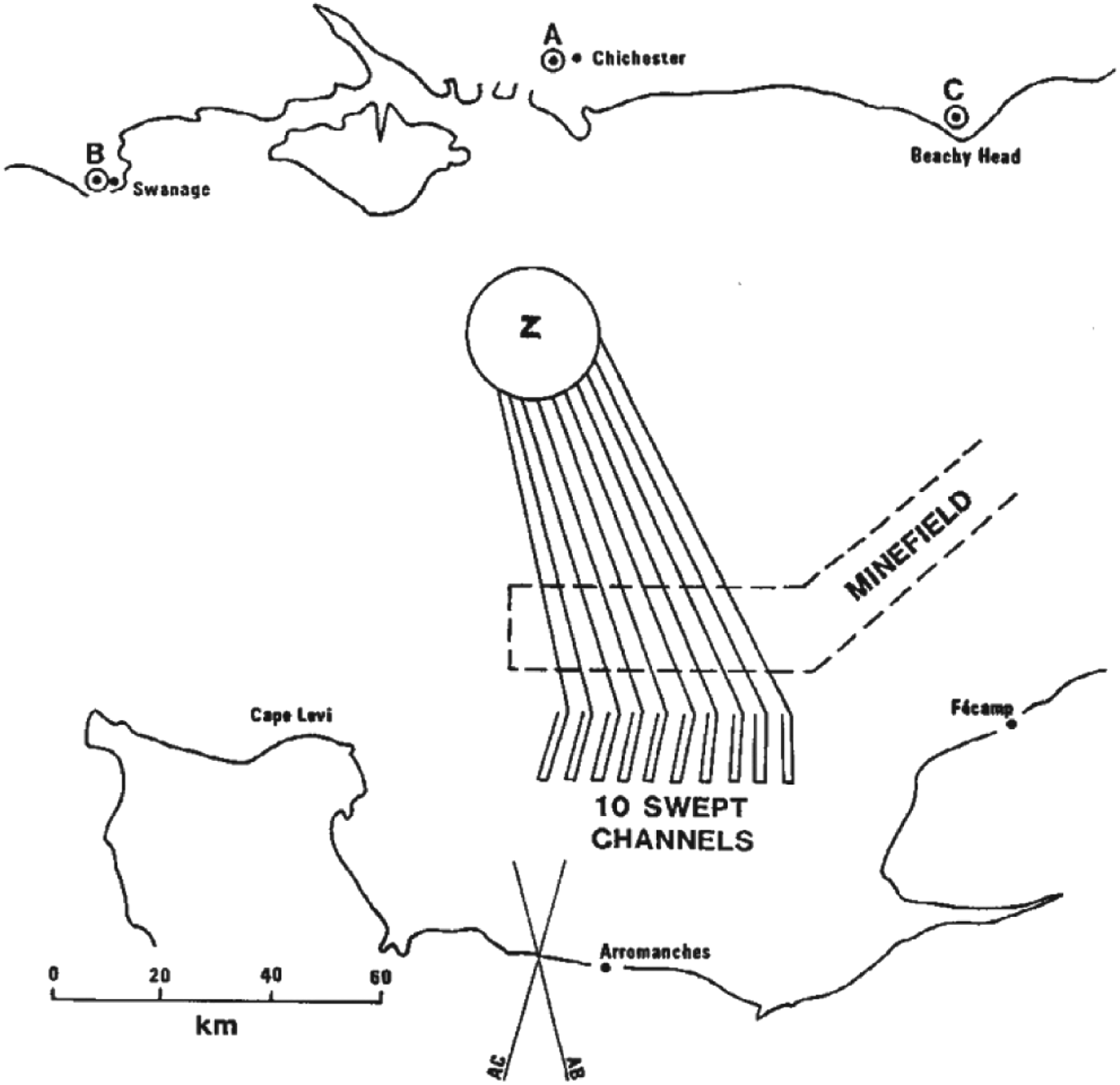
The decision to adopt QM for Neptune was duly confirmed and full security arrangements put in hand. This meant that details of how the system was to be used could not be divulged to O'Brien or Schwarz, being foreign nationals, so Naval crews had to be trained in transmitter operation and knowledge of the use and location of the transmitters was restricted to them. An officer who was concerned with planning the QM chain recalled a problem posed by the high security: “It was an urgent matter to obtain the views of the operation planners on the optimum positions of the three transmitters, in view of the need for extreme accuracy of navigation, especially in the case of the leading minesweepers. At a meeting at Southwick House, we pointed out that, if they told us the landing area, we could plan the best positions for the transmitters. This they were unwilling to do for security reasons and instead chose them themselves, later informing us of the transmitter locations they had decided on. This was equivalent to spelling out the landing area, of course …”
The master station, known as A, was set up near Chichester, the western (red) station B near Swanage in Dorset and the green slave (C) about a mile inland from Beachy Head (Figure 7).
Figure 7. D-Day chain layout.
The transmitters, fed by the special Decca drive equipment, were 5 kW units of Admiralty pattern feeding three-mast T-type antennas 100 feet high. The Hydrographic Department of the Admiralty surveyed the station sites, computed the lattices and prepared the charts. Initially the two sheets latticed were those entitled “Ile St. Marcouf to Cap Manvieux” and “Cap Manvieux to Dives”.
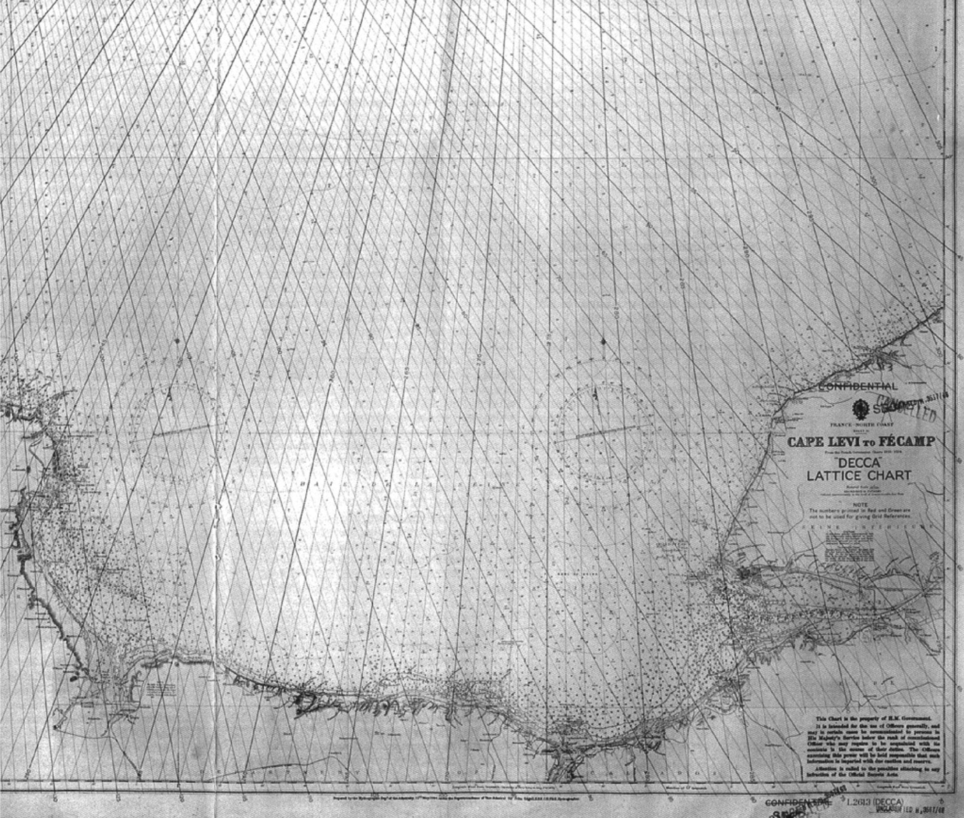
The chain remained in being for some months after the invasion and a third sheet of relatively small scale (Cape Levi to Fecamp) (Figure 8) was added later to cover various operations during that period.
Figure 8. The “Cap Levi – Fecamp” chart.
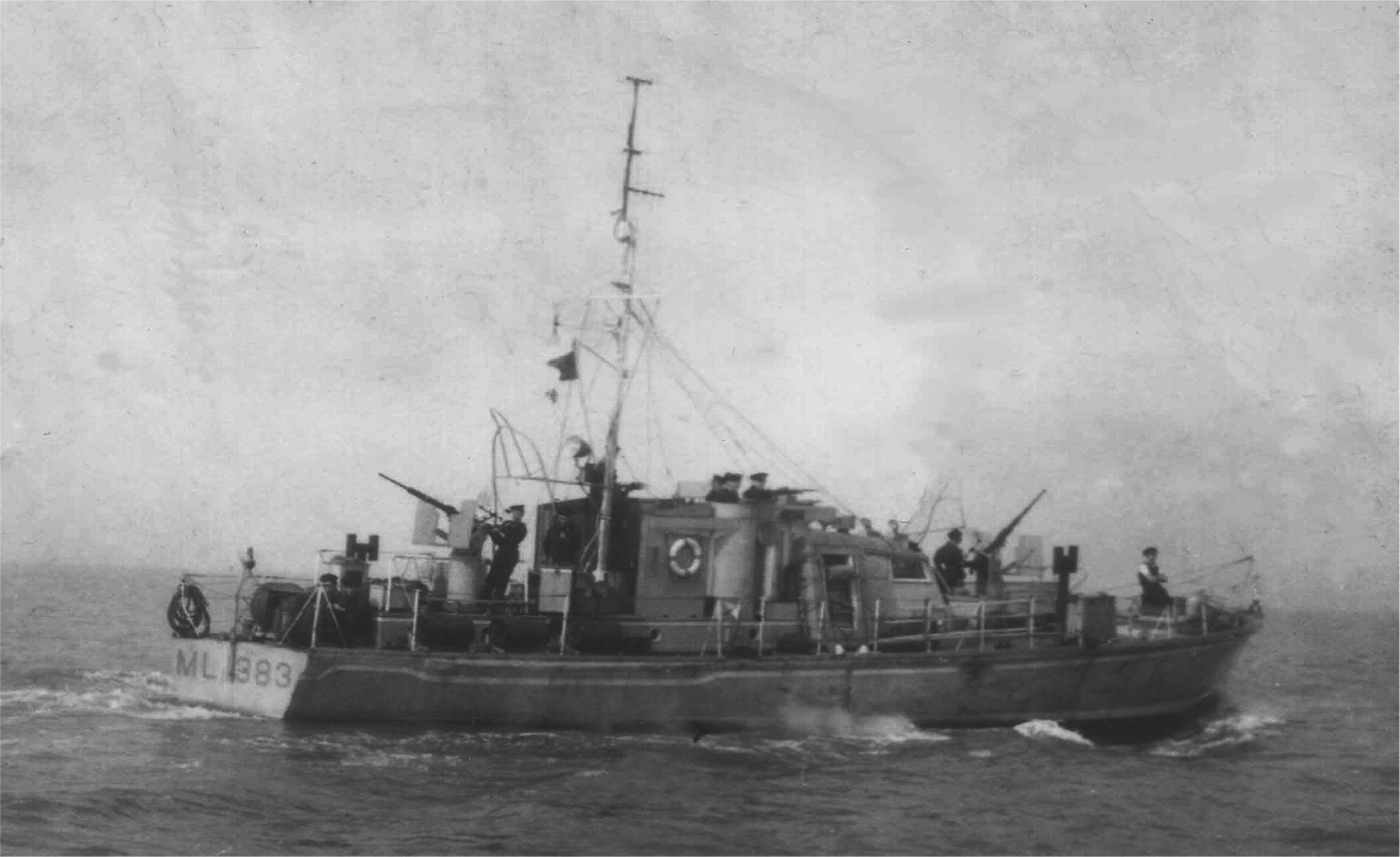
Of the vessels scheduled to use QM (Figure 9) on D-Day, ten were minesweepers (MS 1, 4, 6, 7, 9, 14, 15, 16, 18 and 31); five were landing craft (LCH 275, 317, 168, 239 and 269); and two were harbour defence motor launches (HDML 1383 (Figure 10) and 1387). Four were ships that already carried QM through having taken part in the trials: HM Ships Glenearn, Dacres, Fraserburgh and Harrier. An American ship, the USS Barnett was also supplied with a receiver but this was not mentioned in subsequent reports and no data survives showing how it was used. Vessels that had been fitted with QM receivers before coming to the departure areas, towards the end of May, were able to pick up test transmissions from the newly sited chain. The specialist Navigating Officer of a minesweeper later wrote: (Malleson, Reference Malleson1980).
“On 24th May the tension was broken and we sailed from Harwich … Early next morning off the Nab Tower I had the first chance of trying out the new Decca outfit … my dial pointers clocked steadily round as we passed through the crowded shipping lanes …”
Figure 9. Outfit QM receiver as built for D-Day use.
Figure 10. HDML 1383: Decca aerial was a wire strung up to the mainmast.
The chain started transmitting permanently early on 5th June to cover the minesweeping. In this and in the landings on the following day the QM system proved its worth. The leading units of the minesweeping flotillas were able to maintain steady courses over the ground, in spite of the effects of a beam-on wind and directional changes of tides and currents, and the swept channels and assault approach routes could be properly marked with dan and lighted buoys. Under the conditions actually experienced it was generally agreed that conventional navigation could not have achieved the track-keeping accuracy that was attained. It had been predicted that the QM-equipped landing craft should arrive within 200 yards of their destinations and in many cases the error experienced was much smaller. The QM1 receiver (nicknamed the Blue Gasmeter from the colour of the case and the form of the lane-counting dials) was described by the Navigating Officer just quoted as “uncanny … it seemed as if we had some sort of overhead cable which not only showed us the direction but also our speed…” (Figure 11).
Figure 11. Early QM showing “gasmeters”.
Apart from a 28 minute interruption of the master transmission soon after switching on early in the morning of 5 June, all the equipment functioned perfectly.
In order to attract any attempted jamming away from the A, B and C frequencies, a strong decoy transmission on a fourth frequency, phase-locked to the master signal, was radiated from a ‘D’ station, sited near Sheerness in Kent. In the event, there was no jamming nor any subsequent evidence that the signals had been detected. Even so, two civilians knew for certain when the operation had started: in their flat in Dolphin Square, Schwarz and O'Brien kept their ‘breadboard’ receiver running and saw, on 5 June, that the pointers had ceased the wanderings characteristic of the no-signal condition and taken up stable readings.
It is probably because of the secrecy surrounding all aspects of the use of QM for Neptune that historians have missed the vital contribution it made to that operation. Neither ‘The War at Sea 1939–45’ Vol.III, Part 2 (Capt. Roskill), nor ‘Operation Neptune’ (Vice Admiral B. Schofield) mention it, while Prof. R. V. Jones (‘Most Secret War’, 1978) and R. W. Clark (‘The Rise of the Boffins’, 1962) attribute the accuracy of the minesweeping and subsequent navigation to GEE/QH alone. The Admiralty had in fact asked the RAF to supply a number of GEE receivers to act as standbys for QM and some of the ships carried both, but the few additional GEE sets that the RAF were able to release were not called upon (Fennessey, Reference Fennessey2001). GEE was, however, the main navaid used by numerous ships in the marshalling phase of Operation Overlord which occurred not far off the Isle of Wight and thus well within GEE coverage.
4.4. River Scheldt Survey
A second QM chain was later set up, in the autumn of 1944, to cover the estuary of the river Scheldt, with the object of helping to keep open the supply routes to the port of Antwerp in the fogs and low visibility expected at that time of year. The stations were at or near Bruges, Ghent (master) and Antwerp. A battery-portable receiver, QM2, was quickly developed for use with this chain, suitable to be carried on board by a pilot. As it happened the weather turned out to be exceptionally good and the Allied advance eastward allowed daytime river traffic to be resumed, but the Admiralty took the opportunity to use the Scheldt chain to evaluate the system as a possible aid to hydrographic surveying, wreck-buoying and similar work. The trial was carried out by the survey ship HMS Franklin, under the command of Cdr E. G. Irving, RN; who later became the Navy's Chief Hydrographer. His recommendations on the basis of the results were a key factor in the Admiralty's later support for the establishment of a chain to cover the Thames Estuary.
5. POST-WAR COMMERCIAL DEVELOPMENT
Edward Lewis, the Chairman of Decca, had now to make a major decision – should he continue to support the development of the Navigator for civil use? In his own words (Lewis, Reference Lewis1956):
“In August, 1945, we had our first great post-war opportunity with the Navigator. The Admiralty was interested in a quotation for a short-range Decca transmitting chain for minesweeping and survey work in the Thames Estuary. After much discussion the Admiralty approved the erection at our own expense of a major chain to operate 24 hours a day and granted us a temporary allocation of frequencies. This chain came into continuous operation in July, 1946. It gave us the opportunity of demonstrating the equipment to shipowners and was the cornerstone of all subsequent development of the system.”
In fact, it was not quite as simple as that, nor was the contract quite as Lewis states. When negotiations over its civil use began, in early 1945, the country was still in a wartime situation with everything tightly controlled and little scope for freelance commercial investment; (the subject of his book “No C.I.C.”). Because of this Decca could not get either the materials or the necessary permits to operate without formal Government authority. Complicated questions arose about Decca's willingness to make a substantial financial investment in the system, its technical and marketing ability to support what might become a “safety-of-life” system, Government operational participation, and so on. Negotiations went on for some months and the matter was referred to ASE for technical evaluation assuming a civil environment. Lewis insisted on Decca being solely responsible for its operation and development and eventually it was agreed that if Decca reimbursed the Government what it had invested, mainly work done at ASE estimated at £50,000 (equivalent to about £2M today), all Government rights would be relinquished and Decca would assume complete responsibility, subject only to the usual safety regulations. This still did not give Decca authority to purchase material or even employ additional engineers so to cover all these matters it was agreed that a nominal contract would be issued for Decca to install and operate a chain covering the Thames Estuary, thus technically lending it Government authority (Schwarz, Reference Schwarz1987). The wording of this contract would be interesting to see but unfortunately it has not been possible to trace a copy.
The next step was to seek formal approval from the Board of Trade (BoT) for its use by shipping but there was one outstanding problem to be solved. Its use of low radio frequencies meant it had excellent coverage over the sea and provided far higher accuracy than any previous system but unfortunately the method of phase-comparison used meant that readings were reproduced at every comparison half-wavelength interval (about 400 metres) so that if a receiver was switched on at random then unless there was some other way of determining geographical position to around this level Decca gave multiple possibilities for the same readings, a problem known as “lane-ambiguity”. The main way of overcoming this so far had been to switch on while still in port and integrate from that known position, when it would follow all the ships’ movements and so provide accurate position, rather similar to the dead-reckoning procedure well-known to all navigators. The outstanding requirement for this to work was of course that it followed continuously and there were no breaks in reception due to transmitter or receiver problems. This led to considerable work by Decca on high-reliability transmitters but nothing could be done about at-sea power failures on board user ships, or loss of signals due to natural causes (thunderstorms) or accidental radio interference. Because of this the Board of Trade initially refused to authorise it and insisted Decca worked out some way of overcoming the problem. The Decca engineers (Figures 12 to 14) eventually did so by a clever method of switching radio-frequencies that when mixed together in the receiver periodically produced a much lower frequency of 14 kHz, whose phase ambiguities were so far apart (about 12 km) that there was little doubt which position was right.
This “lane identification” (Figure 15) system was first introduced in 1947 and although sufficient for BoT authorisation to be given needed later refinement (O'Brien, et al., Reference O'Brien and Hawker1954). However, it was only a partial solution and did not completely resolve matters, although it was adequate for most shipping which travelled comparatively slowly.
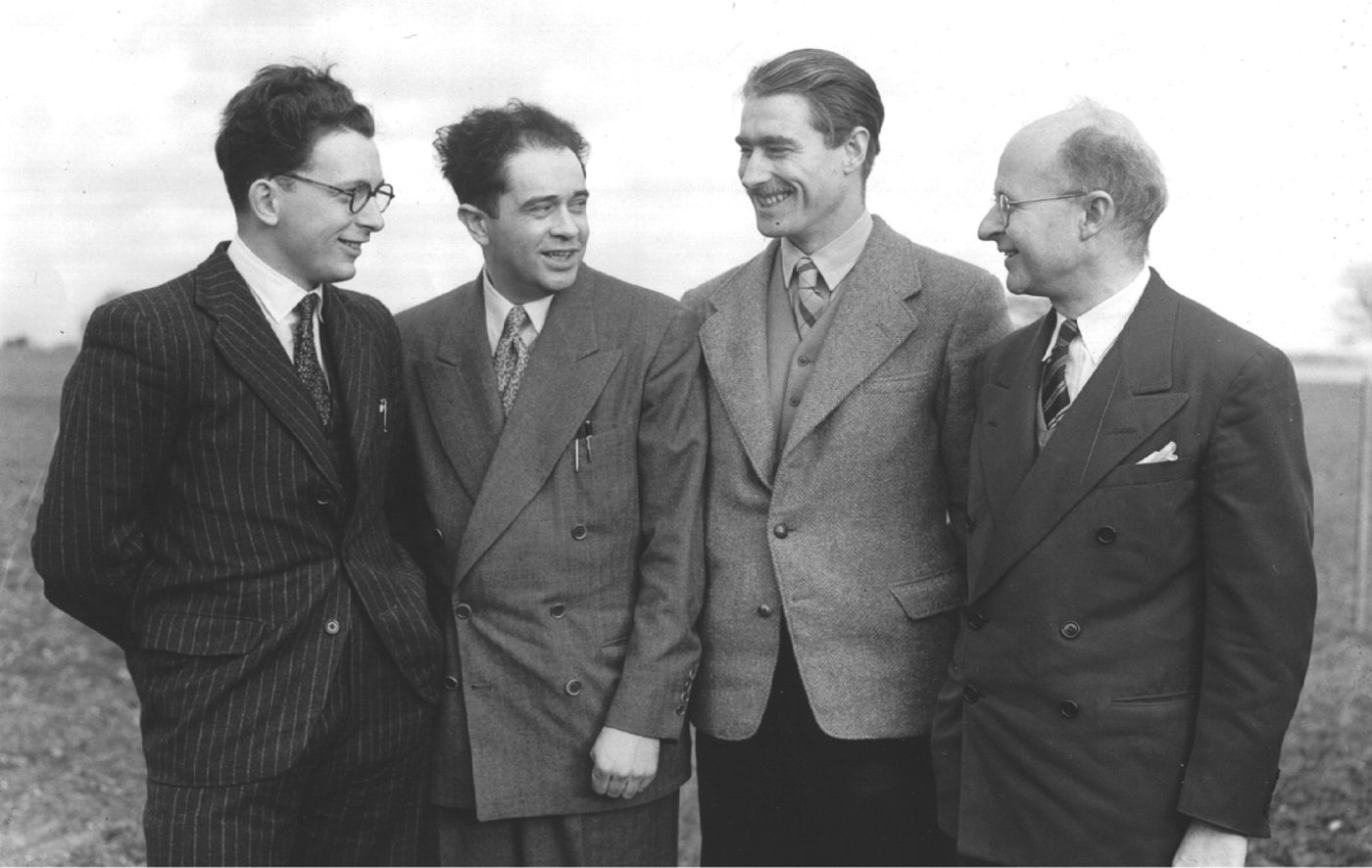
Figure 12. Post-war picture showing O'Brien, Schwarz and the two development units.
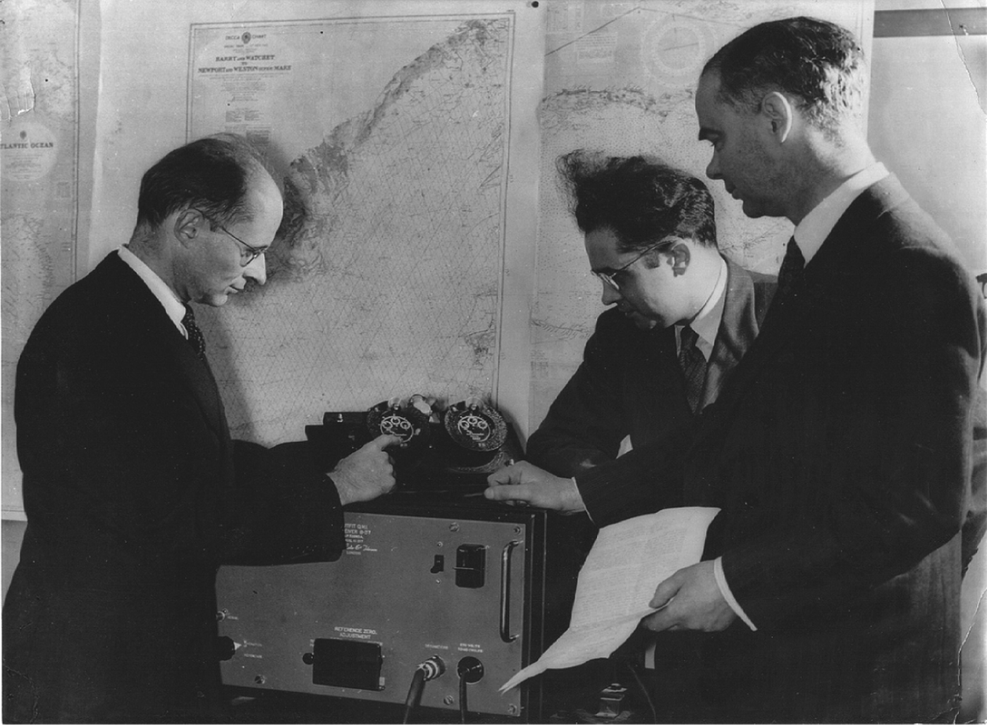
Figure 13. Post-war development team including two new recruits from the Admiralty. Denis Hendley (extreme left) became Chief Engineer in 1955 and Don Bridges (second from right) Head of the Airborne laboratory.
Figure 14. Another Decca group including Edward Lewis (on right), Chairman of Decca Records.
Figure 15. Lane identification switching sequence at the transmitters.
Subsequently, Decca became a favourite of fishermen who now had an accurate system of marking “bottom fastenings” that could wreck their nets, and of locating shoals of fish. The large numbers of such users combined with its use by other vessels for harbour entrance and estuarial navigation made it an almost mandatory fit in ships of all sizes and in 1970 it achieved its peak use with over 30,000 marine users.
6. AVIATION
Schwarz had always had ambitions for Decca to be used for aircraft navigation, indeed the whole system had originally been triggered by an aviation requirement and submitted to the Air Ministry in 1941 as an aerial navaid. Mainly at his instigation it was quite extensively flown and tested in a Lancaster during late 1946 with flights extending as far as the Western Mediterranean and the Azores where signals from the English Chain, the only one in operation at the time, were received fairly reliably (Atwell, Reference Atwell1947). It was perhaps a little unfortunate that this persuaded him into thinking that the whole of Europe might be covered with just one chain and thus eliminate the need for any other aviation navaid, leading in subsequent years to Decca spending far too much time and effort trying to dominate the aviation market as it did the marine. A history of this side of Decca's work and the international complications it caused has no place here; suffice it to provide a short description of the technical problems it encountered there.
Although Decca's use of low radio frequencies ensured that vehicle altitude was not a limiting factor, as it was with VHF aids, two major problems ensured that support for it as a standard aviation navaid was never more than lukewarm. They were that (a) ambiguity resolution to a level adequate for marine users was insufficient for the faster-moving aviators, and (b) the effects of rain and other natural causes of static interference causing loss of reception at low frequencies were much more severe for aircraft than for ships. Until the advent of high-flying jet aircraft in the 60s most aircraft flew at heights where they often encountered static-producing cloud and no matter how much effort was put into developing discharge wicks and other devices it could never be eliminated. It caused temporary loss of the Decca signals and while they were out the aircraft might traverse a number of Decca lanes without being able to count them. When reception was re-established the hope was that the lane identification system would enable correct operation to resume but all too often too many Decca lanes had been lost and the Decca position became unreliable. The aircraft then had to have recourse to other radio navaids for safe navigation and the obvious question arose that if they had to carry another type of navaid anyway to ride over these problems then why carry Decca in the first place? Decca attempted a technical solution by extending the lane-identification principle to ever-lower frequencies, re-arranging the transmission pattern so that an even lower frequency of 0·2f (2·8 kHz) could be derived with lane widths of over 100 km. It was called “Multipulse” and at the time it was introduced (1960), Decca claimed it solved all ambiguity problems, but it had its own problems, notably at the transmitters themselves which were now spending a considerable proportion of their on-air time switching between frequencies and thereby interrupting the steady carrier-wave that had been one of the reasons for Decca's high original accuracy. Also, it required for its proper working that the basic 5,6,8 and 9f transmission frequencies were all being received in proper phase relationships, which at the longer ranges could not be guaranteed. Thus, the claimed range of Decca of around 400 km was reduced in practice to about 200 km and even less in tropical areas where skywave was more intense. In this way Decca lost its sole remaining advantage in greater range over VHF systems and with the steady improvement in VHF accuracy airlines became increasingly difficult to persuade that Decca offered anything. However, Decca was still supreme for low-altitude navigation where VHF systems had limited range and also for specialised applications where its accuracy and ability to produce permanent records via the Flight Log add-ons were valuable. Accordingly, a fair number of users in the helicopter, survey and military areas arose, justifying Decca's maintenance of an aviation division.
An important by-product of this aviation-related work was that Decca correctly saw the need for a map-type presentation for the pilot-only crews that were becoming increasingly common and could not be expected to plot Decometer readings on charts. This led to the development of roller-map devices which automatically plotted the readings from two decometers, called “Flight Logs”. Unfortunately such plotting, necessarily rectilinear, distorted quite considerably the hyperbolic form of Decometer readings and consequently the ground beneath was also quite distorted, requiring special maps and causing difficulty in reading. This was not corrected until the advent of the digital computer in the early 1960s enabled real-time translation of hyperbolae into rectilinear and thus the use of ordinary maps. Decca, to its credit, was probably the first to design and build a specialised computer to do this – the “Omnitrac” computer – which many considered to have been one of the company's major achievements. It would have assumed much greater importance had not Decca insisted for too long that only the Navigator could be used as its positional input and tried to use this as leverage to force Navigator use. By the time it relented and allowed other inputs such as VOR/DME, Doppler, inertial and so on it was too late and others had taken the market, but that is another story.
7. OTHER USES
The basic techniques and equipment developed for the Navigator system found many uses elsewhere, notably in the North Sea oil exploration of the 1970s and 1980s which owed a great deal to it. This business eventually became so important that Decca formed a separate company, Decca Survey Ltd., to exploit it which eventually expanded worldwide encompassing many other non-Navigator-based positioning systems including the satellite-based Transit and GPS. As is well-known, the technical superiority of GPS and its free availability subsequently swept all before it and Decca was finally closed down in stages around the end of the century.
8. FINAL WORDS
It perhaps should be mentioned that to mark the occasion the Institute held a commemorative gathering at Church House on the day (31 March 2000) the last remaining transmitters of the English Chain were switched off. Sponsored by the Racal company, who had bought out Decca in 1981, it was attended by over 400 guests, many of them ex-Decca employees, a demonstration of the great loyalty the company had engendered.