Introduction
This paper describes and discusses glacigenic deformations and fractures in bedrock south of Cranbrook, British Columbia (Fig. 1) and relates them to the glacial movements that have been deduced from fabric and deformations in the overlying basal till. From field observations and measurements, conclusions are drawn on the possible mechanisms of shearing, wedging, and erosion of the bedrock, and the contemporaneous and subsequent deposition and deformation of local and lodgement tills by two competing glacial flows: a regional south-southeastward ice movement and a local, weaker south-westward movement along Peavine Valley.

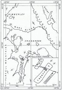
Fig. 1. Area map, with the location plan for the lower three trenches in the lower right corner. The contour line is approximately 1 200 m above sea-level. The study area is indicated by an asterisk. Allignments of drumlins and striae are marked by standard symbols.
Geological setting
The study area is situated along the eastern side of the Purcell Mountains at the western edge of the southern Rocky Mountains trench. The trench is a long inter-montane valley extending northward from Montana into British Columbia and is bounded by the Rocky Mountains on the east and the Purcell Mountains of the Columbia Mountains system on the west.
During the Pleistocene, the southern Rocky Mountains trench served as an outlet for the Cordilleran ice sheet, which had been formed by the coalescence of large valley and piedmont glaciers in the Rocky and Columbia Mountains (Reference ClagueClague, 1975). Observations of striae and other geomorphological features, along both sides of the southern region of the trench, indicate that maximum thickness of the ice sheet was about 1 600 m above the present trench floor (Reference DalyDaly, 1912; Reference Monger and PretoMonger and Preto, 1972; Reference ClagueClague, 1975).
A southward glacial movement dominated in this area with minor deviations caused by local valley systems. North of Cranbrook a significant split in glacial direction appears to have taken place. Drumlinized ground moraine and striae to the north-cast indicate a southeastward (140°) glacial movement roughly parallel to the Kootenay River. North-west of Cranbrook, however, the topographic features and striae indicate a south-south-westward (190–200°) ice flow. In the area investigated, in addition to the regional direction of movement (170°), a local south-westward (200–240°) movement was encountered along Peavine Creek Valley. This was caused by a localized glacial flow along the valley.
Field investigations
As a result of geologic investigations by Cominco Ltd in 1977, seven trenches were excavated 12 km south-south-west of Cranbrook, at the eastern fringe of the Purcell Mountains, on the north-west side of Peavine Creek Valley (Fig. 1). The trenches were located at successively higher elevations along the valley side which slopes at 22–24° towards 125°. The lowest one (No. 1) was at the valley floor, about 1 000 m above sea-level, the highest (No. 7) about 100 m above it. Seismic studies by Cominco Ltd have shown that here the valley floor is approximately 100 m above the bedrock and has been filled by unconsolidated sediments.
The trenches were cut through 0.2–7 m of Quaternary deposits, mainly till and/or colluvium, into 1–3 m of bedrock, exposing up to 3 m of fractured and deformed quartzite. The nearly vertical trench walls were mapped in detail, using a mosaic of photographs as base maps. The strike and dip of about 600 fractures were measured in the bedrock and compared with the fabric measurements in the overlying till (Reference Broster and DreimanisBroster and Dreimanis, unpublished).
General description of trench exposures
Bedrock—general
Trenches 1–3 were chosen for detailed study because they contained both bedrock and 2–7 m of till (Figs 2 and 3). The bedrock is Middle Aldridge siltstone, a fine-grained competent quartzite striking 35–40° and dipping north-westward at 20°; it contains a gabbro dyke striking 115° and dipping south-westward at 70° (Figs 1 and 3).

Fig. 2. Cross-section X–Y. P, Peavine Valley till or shear plane; R, till deposited by regional ice flow; 1–24, till sampling sites. For location see Figure 1.

Fig. 3. Section along the western wall of trench 3. Numbers 3–7 are sample locations.
Weathering of the bedrock is seen only adjacent to the dyke and along those fractures which strike parallel to it. Fresh fractures which have not been cemented, and in some cases contain injected unconsolidated sediment, are abundant in the rest of the bedrock, but most of them are oriented differently from the dyke. The bedrock–till contact is distinct in the lower two trenches (1 and 2) but is less clearly defined in the upper trench (3). Here, the bedrock surface has been extensively fractured and also contains wedge-shaped injections (Fig. 3).
Bedrock zones
The upper part of the bedrock exposed in the trenches may be subdivided into three zones, A, B, and C, according to the degree of fracturing with downward decreasingintensity (Fig. 4). The uppermost zone A is generally about 10 cm thick and is characterized by a very high degree of fracturing; in trenches 1 and 2 the bedrock has been broken into small trapezoids less than 5 cm2 in surface area. In trench 3 (Fig. 3), zone A is represented by an even finer crushed bedrock. These fragments appear to be aligned in a somewhat platey orientation sub-parallel to the bedding with silt and rock flour separating them. Slickenside-like polish and striations, in varying degrees of preservation, can be found on the surface of the rock fragments. The slickenside-like striae trend from north-north-west to south-south-east, parallel to the regional glacial movement, and are indicative of displacement. No other displacement parallel to the bedding planes is evident below this zone.

Fig. 4. Bedrock zones A, B and C in trench 2; A is overlain by lodgement till. The knife is 26 cm long.
The next deeper zone B is 1–2 m thick and moderately fractured, with horizontal fracture spacing usually about 5–50 cm. Occasional wedge-shaped injections of brecciated rock or sediment cut across this zone and even extend into the lower, still less fractured zone C. In zone C the injections are present but they taper off downwards and contain only silt-sized materials. The horizontal spacing of fractures varies from 0.5 to 1 m in zone C. Both zones B and C are present in all the trenches and grade into each other, while a distinct contact exists between zones A and B.
Fractures
Fracture orientations, and their relative abundance in the three bedrock zones, show that they belong to four groups. The first group of fractures, spaced at 2–50 cm intervals, is sub-parallel to the bedding and may reflect the original bedding planes accentuated by stress relief (Reference LeechLeech, 1966) during and after deglaciation. They are present in all three zones A, B, and C. The second group is most abundant in bedrock zone C and least abundant in zone B. The majority of these fractures are parallel to the dyke, striking 115°, but some sets are random and unrelated to the orientation of the dyke or to glacial activity. Most fractures of this group are cut by fractures of the third and fourth groups.
The third group are those fractures which strike perpendicular to the direction of movement of the regional ice. These fractures are fresh with moderate infillings of fine sediment and occasional injections along southward-dipping fractures planes. This group consists of the most prominent and best-developed fractures in bedrock zone B and they are the second most abundant fractures in zone C. The wedges are related to this fracture group.
The fourth group are those fractures which strike perpendicular to the south-westward movement of the local Peavine Valley glacier. This group is the second most abundant in bedrock zone B and is the least abundant in zone C. Both third and fourth group fractures occur in conjugate sets which consist either of: (a) low-angle fractures dipping 5–20° from the horizontal, or (b) high-angle fractures dipping 65–80°.
Injection wedges
Sediment-filled, wedge-shaped fractures can be found in all three trenches, striking 80° and dipping towards 170°. These are most clearly developed in trench 3 (Figs 3 and 5). Here the wedges are slightly curving. In section they are steeply dipping at their upper end (45–70°), closest to the bedrock–till contact. The dip is generally less steep at their lower tapered end but varies depending on the orientation of the bedrock fractures that were encountered during formation of the wedges. The width of the wider upper end ranges from 4 cm to about 1 m. The maximum length of the wedges is unknown because many extend below the excavated floor of the trenches. One of them can be traced for more than 3 m along the exposure face before disappearing below the trench floor. The wedges are filled with debris (Table I, samples 5–7) ranging from clay to brecciated rock and a few contain till. The silt-rich parts of the wedges are mainly along their base, and they are laminated parallel to the rock wall. The wedges resemble similar structures which have been found in bedrock and unconsolidated sediments, and described by several authors, e.g. by Reference Goldthwait and KrugerGoldthwait and Kruger (1938) as clastic dike injections in bedrock, by Reference LundqvistLundqvist (1967) as till dikes, and by Reference DreimanisDreimanis ([c1969]) as till wedges.

Fig. 5. A wedge north of the dyke in the west wall of trench 3.
Table I. Selected analytical data. Sample locations in Figure 3

Till
The till overlying bedrock (Figs 3 and 4) consists of two sub-units: a local till (LcT) and a typical lodgement till (LgT), both stratigraphically comprising one till layer.
Local till
It is thickest in trench 3 (up to 1.5 m), consists mainly of fractured angular local bedrock fragments, in some parts of the section separated by fracture patterns similar to those of bedrock zone B. When viewed from a distance, these parts resemble bedrock rather than till. However, on closer examination, interstitial till material and silt are noticeable along the fractures, as well as the presence of distally derived clasts. At the south-western end of trench 3 (Fig. 3) a 2 m long strongly fractured and sheared slab constitutes most of the local till. The dominant fractures in this slab strike 80°, dip up-glacier, and have been deformed into a sigmoidal shape. Similar deformations can be found in small bedrock blocks incorporated in local till elsewhere in the trenches.
Lodgement till
In trenches 1 and 2, the bedrock is in sharp contact with typical lodgement till, while in trench 3 the lodgement till grades downward into local till, which overlies bedrock. The lodgement till consists mainly of sandy silt or silty sand and contains occasional pebble-rich zones. Well-developed fissility is present in some parts of the till, grading in places into shear planes, particularly in trench 1. The lodgement till consists of two alternating sub-units (Fig. 2), one of them (R) having been deposited by the regional glacial flow from north-north-west, and the other (P) by the local Peavine Valley glacier. These sub-units have been described in more detail by Reference Broster and DreimanisBroster and Dreimanis (unpublished), and the dominant alignment of till pebbles measured at 13 sites (Fig. 2) is included for clarity.
The alignment of pebbles has some common trends in the fabric diagrams. Most diagrams display well-developed bimodal or single maxima: (a) 160–170°, parallel to the regional glacial movement of the area, as recorded by striae (Fig. 1), and (b) 040–050°, parallel to the dip of the north-east, dipping fissility and shearing in the local Peavine Valley till (P) in trench 1.
Discussion
Fractures F1–F3
The principal Compressive stress direction, τ1, is assumed to bisect the acute angle formed by conjugate shear planes (Reference PricePrice, 1966). Analysis of the shear fracture orientation in bedrock reveals several sets which show consistent relationships in time and space (Fig. 6). The earliest set of low-angle shear fractures (F1) appears to have been initiated by a compressive stress plunging at 20° towards 170°. It is followed by the formation of two distinct sets of mutually cross-cutting low-angle conjugate fractures with principal compressive stresses plunging at 5–20° also towards 170° (F2 R) and at 20–30° towards 210° (F2 P). Succeeding these low-angle fractures are two sets (F3 R and F3 P) with τ1 pointing in about the same directions as F2 R and F2 P, respectively, but plunging at 70–80°, resulting in high-angle, normal shear fractures. (The direction of the F3 R points slightly more towards the south-east at 150°, rather than the 170° of F2 R.)

Fig. 6. Lower-hemisphere Lambert projection showing mean principal compressive stress directions τ1 for conjugate fracture sets F2–F3 in trenches 1–3. F1 is mean of all three trenches.
The principal compressive stress directions for F1–F3 correspond to one or both of the directions of the two independently derived glacial movements: the regional (R) south- to south-eastward and the south-westward Peavine glacial flow (P) as deduced from striae and clast fabrics. Both of them are unrelated to the deeper bedrock fractures trending parallel to the mineralized dyke at 115°.
The early fractures (F1 and F2) are characteristically low-angle shears that imply low ratios of vertical stress to horizontal stress. In addition, the initial south-south-eastward stress is followed by two principal stress directions. This may be explained by the development of variable stress systems during the approach of the regional and Peavine Valley glaciers that created low-angle compressive stresses in the underlying bedrock. Concomitant with the expected increase of ice thickness with time is the development of high-angle shears, for which the principal compressive stresses plunge steeply, but still parallel the directions of the two glacial movements. A continuum of stress systems between the low- and high-angle shears was not observed. This continuum may have been absent because the rock failure occurred only under specific conditions during the ice advance. The presence of silt along some shear fractures suggests water movement under warm or temperate ice undergoing pressure-melting during or after fracturing, and the injection of silt from above.
Generation of low-angle shear stresses would be expected at the beginning of the glacial advance: first by the regional glacier from the north-north-west followed by the Peavine Valley glacier joining it from the north-north-east. The combined effect of two coalescing, rapidly moving, and thickening glaciers on the sloping face of a mountain could subsequently create a complex stress system that would produce fast strain-rates and large shear stresses within the bedrock. The evidence for two directions of glacial movement affecting bedrock matches the pattern of ice advance also deduced from the till data.
When a multi-fractured bedrock surface with numerous planes of weakness had been developed by the above stresses, the bedrock would have been susceptible to further deformation and erosive effects during continued glacial over-riding.
Injection wedges
One of the deformations associated with downward injection of watery sediments was the formation of injection wedges (W) in the fractured, bedrock underneath the base of the moving ice. A close examination of the injection wedges (Figs 3 and 5) shows that detrital material (Table I, samples 5–7) has been forced down pre-existing cracks dipping down-glacier to the regional movement. Only this particular orientation of fractures was found to contain distally derived clastic debris.
The following model (Fig. 7) is proposed for the formation of these glacially induced injections. Movement by the regional ice had displaced the upper (down-glacier) bedrock block relative to the lower (up-glacier) one. This had taken place either by freezing the block to the sole of the glacier or because of friction along the glacier bed. The result was circular rotation of the down-glacier block, such that the up-glacier side of the block would be rotated upward into the sole of the glacier. Protrusion of this block into the glacier sole would cause an obstruction and the initiation of pressure-melting at the point of contact. The production of water by pressure-melting would explain the injection of the 0.5–10 cm thick silt laminae (Table I, sample 5) that form the narrower injections and are also noticeable along the base of the wide wedges (Fig. 3). The presence of abundant small fractures in the bedrock adjoining the silt wedges suggests repeated freezing of water along the silt injections, resulting in the further widening and extension of the fractures. It is likely that the bedrock was frozen prior to and at the beginning of the formation of the wedges. In such a case, initiation of the wedge formation may have been by a process similar to the “tensional" model of glaciotectonics as suggested by Reference Banham, Wright and MoseleyBanham ([c1975], p. 79, fig. 7), but on a much smaller scale. Further development of the wedges by continued injections would, in contrast, require temperate ice and pressure-melting.

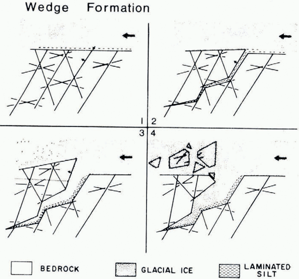
Fig. 7. Sequence of wedge formation. (1) Seepage from base of glacier into glaciotectonic fractures; (2) depostion of fine sediment–water slurry displaying laminated fissility parallel to the fracture walls; (3) displacement of down–glacier block by glacial drag and/or freeze–thaw and injection of debris-rich material from base of glacier; (4) fracturing and incorporation of the projecting down-glacier block by glacial over-riding.
With continued glacial movement of the upper block into the glacier sole would cause further widening of the fracture and a downward extension of it at a gentler dip angle, or along pre-existing fractures at various angles, but dipping down-glacier (Fig. 3). During the widening of the fracture(s), water-saturated silt and glacial debris would be injected from the glacial sole above. The widening of the top part of the wedge would continue until such time that the pressure exerted by the movement of the glacier resulted in failure of the down-glacier block. Failure is believed to have been aided by pre-existing shear fractures and bedding-plane fractures. The upward protrusion would have been eventually eroded (piece by piece if it consisted of the highly fractured bedrock zone A, or as larger masses of bedrock, if the erosion extended into zone B). This process would have continued until the protrusion ceased to be an obstacle to glacial movement.
The size and amount of infilling is dependent on: (a) the amount of protrusion (upward rotation) of the down-glacier block, (b) the relative displacement of the blocks imparted by the over-riding glacier, (c) the resistance of the rock to brittle failure, and (d) the intensity of pressure-melting and freezing during the initiation of the wedge. The timing of wedge formation, in terms of the thermal regime of the glacial base and underlying substratum, is believed to begin during the existence of cold ice and to continue during a change to temperate ice.
Deposition of local till (LcT)
The deposition of local till coincides in time with the widening of the wedges and erosion of the protruding tops of the displaced bedrock blocks. During this combination of erosion and deposition by the regional ice, displacement (F4) of bedrock is noticeable above the bedrock–till contact, particularly in the bedrock inclusions in the local till. This is believed to have been initiated by propagation of fractures parallel to the south-south-east dipping F2 R planes. These planes supplied a zone of weakness along which there were high effective shear stresses for movement parallel to the main direction of glacial movement.
Percolation of water and formation of high hydrostatic pressures along these zones (Reference Boulton, Price and SugdenBoulton, 1972; Reference Clayton, Moran and CoatesClayton and Moran, [c1974]) would aid both in propagation of the fractures and reduction of friction during movement. Some frictional effects can be seen in the deformation of a rock inclusion in the local till: the deformation of earlier fractures into a sigmoidal shape (Fig. 3). The following mechanism is suggested for the sigmoidal deformation of this block. The block represents a region in the base of the glacier that moved at a speed less than that of the ice above it. This displaced the pre-existing fractures, flattening them up-glacier in the lower zone of traction. After the block became stationary, the glacier continued to over-ride the upper area of the block, flattening the upper area. Ductile, cataclastic processes are thought to accommodate this deformation (F4), leading to further disaggregation of the bedrock block. In this case, this was accomplished by the infilling of sediment during separation of the individual rock fragments along shear planes, and also by continued comminution of the rock fragments. This resulted in the block having been stretched out in the direction of glacial transport. Initially, only local rock flour is likely to occur along fracture surfaces. This is followed by silt from the glacier sole and finally till, as the spaces between the rock fragments increase. Eventually, the fragments are dispersed until they become disseminated clasts in the till. As glaciation proceeds, comminution and shearing is still imparted by the movement and weight of the glacier but, as the till thickens, the effects are absorbed by the till.
Deposition of the lodgement till (LgT)
Lodgement was initiated by the same regional south-south-eastward glacial movement that was active during the formation of (W), (LcT), and (F4). Lodgement by the regional glacial flow alternated with deposition by the Peavine Valley flow. Both glacial flows were apparently part of a common mountain ice sheet, rather than being simple competing glaciers. This conclusion is supported by the near-continuous interaction of both ice flows during the formation of (F2), (F3), and (LgT). The absence of the effects of Peavine Glacier at (W), (LcT), and (F4) indicates that the combined action of both glaciers existed at the beginning of the glacial advances, when (F2) and (F3) were produced, and at the end, during deposition of (LgT). Further details of the interaction of the regional and the Peavine glacial flows during the deposition of the lodgement till have been discussed by Reference Broster and DreimanisBroster and Dreimanis (unpublished).
As this present paper deals with glaciodynamic deformations, it should be mentioned that a shear fracture, about 3 m long, striking 080° and rising south-eastward at various angles, was observed cutting through a 25 cm long boulder in the local till at a level halfway between sites 11 and 12, and then rising steeply through the lodgement till. The displacement in the boulder is only a few centimetres. It is believed that this shearing took place during the final stages of glaciation, as the shear plane rises past sample site 13 (Fig. 2).
Conclusions
The orientation of till clasts, bedrock striae, fracture systems, and other evidence suggest that during the last glaciation the area investigated was affected by two glacial bodies belonging to a mountain ice sheet: a regional glacier flowing from north-north-west and a glacier flowing south-south-westward along Peavine Creek Valley. Both glaciers merged into a mountain ice sheet and deposited till which, although internally complex, is stratigraphically a single layer. The till is deposited over fresh bedrock which is weathered only along a gabbro dyke.
Several erosional and partially depositional phases can be recognized as having occurred in the following sequence:
-
1. The earliest conjugate fracture systems (F1) appear to be related to the initiation of a main compressive stress from the north-north-west concurrent with the direction of regional glacial flow. Since it is a low-angle compressive stress, this implies that the low vertical pressures could be due to the arrival of thin ice.
-
2. This was followed by the formation of two synchronous sets (F2 R and F2 P) of low-angle shear fractures with main compressive stresses parallel to 170° (regional) and 030–040° (local). These suggest the interaction of two thin-ice glaciers or glacial flows within the mountain ice sheet.
-
3. The ice began to thicken, leading to the formation of high-angle conjugate fractures (F3 R and F3 P) in the bedrock related to both of the above ice-movement directions.
-
4. Concurrent with the dominant action of the regional glacier on the bedrock, wedges (W) developed along pre-existing shear fractures perpendicular to glacial movement and dipping down-glacier (south-south-eastward). The formation of these wedges resulted in the development of rock protrusions upward into the sole of the glacier, that were eroded and deposited into the local till (LcT) and subsequently deposited over and down-glacier ofthe wedges. The deposition of the local till was followed by sigmoidal deformation (F4) of fractures within bedrock inclusions by continued movement of the regional glacier.
-
5. The main depositional phase was accomplished by lodgement of till (LgT) during which both glacial flows competed for superiority. Shearing and fracturing continued concurrently with lodgement to a decreasing degree, producing fissility and shear planes rising down-glacier.
Wedging (see phase 4) may be considered as a process aiding glacial erosion but it has rarely been described previously, and warrants future investigation.
Acknowledgements
The authors are grateful to Cominco Ltd for their financial and logistic assistance in this investigation and their permission to use the data collected while the first author was employed by them. Part of the research expenses were covered by the National Research Council of Canada grant A4215 to the second author. We are grateful also to Dr E. A. U. Parviainen for his assistance in field investigations, to K. Lootsma for doing the laboratory analyses, R. Ringsman for drafting the figures, R. Vasiliadis for the initial typing of the manuscript, A. Gibbard for improving the style, and P. L. Gibbard, R. P. Goldthwait, S. R. Hicock, and H. C. Morris for comments and suggestions.
Discussion
R. W. May: I would like to make a plea that those who are measuring fracture and joint orientation in tills also provide as part of the information the orientation of the face and/or the valley walls on which the measurements are made. In Alberta we have found on occasion that fracture or joint systems in tills are related to stress release parallel to the face of the exposure.
A. Dreimanis: In our study the information you request has been provided in the location plan of trenches 1–3 (Fig. 1) and in the descriptive comments in the text. None of the fracture patterns discussed in our study was parallel to the slope of the valley side, and therefore they were not caused by stress release parallel to the face of the exposure.