


Introduction
In the McMurdo Sound region (southern Victoria Land, Ross Dependency, Antarctica) the mean annual air temperature is about −20°C. Because of this extreme cold, ice may persist for some centuries when covered by a layer of glacial till sufficiently thick to insulate it from the brief period of summer warmth, and to inhibit direct sublimation. The ice-cored moraines surrounding Black Island and Brown Peninsula (Fig. 1), and forming the isthmus joining the latter to Mount Discovery, are examples of such persistence. A knowledge of the distribution of buried ice is desirable for a full understanding of the glacial history of the region, but the presence of frozen ground makes it extremely difficult to reach the ice by digging. Reference ØstremØstrem (1959, Reference Østrem1962) showed that seismic refraction could be used to study ice-cored moraines in the Kebnekaise area of Sweden, and it appeared that this method might also be employed in Antarctica.

Fig. 1. The McMurdo Sound region and dry valley area, south Victoria Land, Antarctica
Reference GoughGough (1952) has described a form of seismic apparatus suitable for shallow refraction studies of terrestrial structure (less than 50 m. depth). During the 1964–65 summer the writer used a Thiokol Chemical Corporation “Geochrone” (a similar instrument, but simpler and more portable) for investigation of superficial deposits in various parts of the McMurdo Sound region.
Seismic waves were created either by a sledge-hammer blow on the ground or by surface detonation of a small explosive charge (50—100 g. “AN60” polar gelignite). The pulse from a geophone beside the shock point opened an electronic gate to admit pulses from a 1 kc./sec. oscillator to a dekatron counting unit. When the first seismic wave arrived at a second geophone placed at a distance from the source, the resultant pulse (which was amplified) closed the gate so that the travel time was directly indicated on the counters in milliseconds. Repeated readings at various amplifier gain settings enabled determination of the minimum travel time (which always corresponds to either the direct or refracted wave) and thence construction of a travel-time curve for various distances from the shock source. Interpretation of this form of graph in terms of a horizontally layered model has been discussed by Reference JakoskyJakosky (1950), Reference DobrinDobrin (1952), Reference HeilandHeiland (1963) and Reference ThiokolThiokol (1964).
The major disadvantage of this instrument compared with that described by Gough was that the received wave form could not be examined, allowing the possibility of misinterpreting later pulses (or the slower S-waves) as the first P-wave arrival. Precautions were taken against this by examining the consistency of results and observing the effect of larger source shocks and various amplifier gains on measured travel times. It is believed that the results presented here all represent true first-arrival P-wave data.
Seismic Velocities in Ice and Frozen Ground
To detect buried ice using seismic refraction it is necessary that the velocity of sound be greater in the ice than in the overlying frozen ground. The velocity in ice lies between fairly well-defined limits, although it depends to some extent on the origin and history of the ice. Reference ØstremØstrem (1962) measured a velocity of about 3,830±100 m./sec. in stagnant ice within moraines. The present writer obtained 3,650±150 m./sec. for clear ice near the upper limit of the ablation zone of Tasman Glacier (New Zealand) and 3,650±150 m./sec. for the blue ice of a frozen lake at Brown Peninsula, McMurdo Sound. Roethlisberger (Reference Röthlisberger and Raasch1961) measured a velocity of 3,800±80 m./sec. at the edge of an ice cap near Thule, Greenland.
Seismic velocities in firn, both dry and brine-soaked, were also measured (Reference Bell and HeineBell and Heine, 1965) and were found to be somewhat lower (1,100–3,000 m./sec.) than in clear ice.
Information on seismic velocities in frozen ground is scarce. Østrem measured a P-wave velocity of 2,500±100 m./sec. for frozen till. Near Thule in Greenland, Röthlisberger measured velocities of 4,780±90 and 4,630±90 m./sec. in frozen till and frozen outwash, respectively. Thiokol has quoted 1,500 m./sec. as typical for the velocity in frozen ground but noted that it is very variable and depends on temperature and the nature of the ground. (See the U.S. Air Force Handbook of Geophysics (1960) for further discussion.)
Knowing the discrepancy between velocities given by Röthlisberger, Thiokol and Østrem, the author took the opportunity of making refraction measurements of seismic velocities in frozen ground in Wright, Taylor and Miers Valleys, and on Brown Peninsula (Fig. 1). These results are presented in Table I. Near the western shore of Lake Vanda, Wright Valley (Fig. 2), the thin unfrozen surface layer was cleared to place the geophones directly on permafrost. Measured velocities of 3,400–4,000 m./sec. confirmed the less direct refraction results.
Table I Seismic Velocities in Ice and Frozen Ground


Fig. 2. Central section of Wright Valley, Antarctica. Specific localities referred to in the text are indicated by the letters A–K
With only one exception, all velocity measurements for frozen ground fell within the range 3,000–4,300 m./sec., which spans the range for ice (3,600–3,800 m./sec.). Consequently, frozen ground and ice cannot be positively distinguished by means of seismic velocity measurements.
A velocity of 5,200 m./sec. was measured in frozen till 0.33 km. east of Lake Miers. This measurement was not repeated in the reverse direction so that doubt remains as to whether it represented a true velocity or whether it was due to a sloping interface with the overlying unfrozen material.
Velocity in Unfrozen Surface Materials
In all cases where frozen ground was indicated by the apparatus, frost polygons (Reference PéwéPéwé, 1959) were visible and gave geological confirmation of the presence of permafrost. The polygons were generally most sharply developed where the overlying unfrozen layer was thinnest (Fig. 3).

Fig. 3. Frost polygon (sand-wedge tesselation) running from the shore of Don Quixote pond, indicating frozen ground. Decreasing sharpness away from the shore indicates increasing thickness of unfrozen overburden. The satchel at the right centre is 30 cm. wide
The thickness of the unfrozen layer varied from zero near shores of lakes to about 2 m. just above a prominent fossil shoreline at a height of about 20 m. above Lake Vanda (Fig. 2). Velocities in unfrozen layers are given in Table II. Generally, the coarse tills of Miers Valley and Brown Peninsula (some dry and some damp from recently melted snow) gave a higher velocity (1,200–1,500 m./sec.) than the sandy loess or mixed grey- to mustard-coloured dust and fragmented rocks (300–640 m./sec.) of Wright and Taylor Valleys. Near the western shore of Lake Vanda a few inches of sandy loess was underlain by a finer, well-compacted, silt-like material which may have been loess compacted by submersion or silt deposited when the lake was at a higher level. The velocity in this silt-like material was 760—900 m./sec. between the present lake shore and the fossil 20 m. shoreline, but beyond the latter the velocity was 1,200–1,500 m./sec.
Table II Seismic Velocities in Unfrozen Materials
(for localities see Figure 6)

South-east of Lake Vanda (Fig. 2) is an area of interbedded Vanda lamprophyre and Dais granite (Reference McKelvey and WebbMcKelvey and Webb, 1962) not covered by till or loess, but highly fractured. The velocity in these rocks was found to lie between 1,500 and 2,500 m./sec., but the scatter of travel times was such that no useful estimate of shattering depth could be made.
Depth of Exfoliation of Granite
In Taylor Valley a large exposure of granodiorite 0.75 km. south of the hut at the eastern end of Lake Bonney has exfoliated in large sheets (up to 5 m. diameter and 0.5 m. thickness). Figures 4 and 5 show travel-time curves on this exfoliated outcrop at different altitudes. Figure 4, determined at an altitude of 150 m. above Lake Bonney, indicates a surface layer 3.4±0.6 m. thick with a velocity of 1,200±120 m./sec., underlain by a layer with velocity 4,900±500 m./sec.

Fig. 4. Seismic travel-time data, Taylor Valley, on exfoliated granite at an altitude of 150 m. above Lake Bonney

Fig. 5. Seismic travel-time data, Taylor Valley, on exfoliated granite at an altitude of 250 m. above Lake Bonney
The data of Figure 5 (from an altitude of 250 m. on the same outcrop) are less easily interpreted. It appears from careful examination of the travel times observed at various gain settings that the surface layer had a velocity of 1,200±150 m./sec. and was 1.8±0.3 m. thick. Under this was a layer 6.0±1.5 m. thick with a velocity of 3,200±300 m./sec., whilst deeper than that the velocity rose to 4,600±300 m./sec. Although the intermediate layer was 6 m. thick, velocity relations were such that it did not appear on the first-arrival graph and was only detectable at lower gain settings. The fact that the slope of these later arrivals does not parallel that of the first arrivals makes it unlikely that they were due to a later peak of a refracted pulse. Circumstances prevented a run in the opposite direction but the uniform nature of the exposed rock surface makes the presence of a sloping interface seem unlikely.
With the above reservations, it may be deduced that coarse exfoliation probably penetrates 6–9 m. into the rock and that beneath the surface 2 m. the rock was either cemented by ice or was significantly less drastically fractured. The dry air and summer warmth could easily sublime ice from near the surface thus permitting ice to remain only in the deeper cold rocks. It might accumulate there from melting snow in autumn and spring.
Depth of an Ice-free Moraine in Wright Valley
Descriptions, photographs and maps of the various moraines of the Wright–Victoria Valleys system have been given in papers by Reference BullBull (1962), Reference McKelvey and WebbMcKelvey and Webb (1962), Reference BullBull and others (1962), Reference GunnGunn (1963), Reference CalkinCalkin (1964) and Reference NicholsNichols (1965).
One of these moraines was found to be free of internal ice. It is situated at the eastern end of the south fork of the valley, 1.5 km. south-west of Lake Vanda (Figs. 6 and 7) at an altitude of about 280 m., much higher than the highest fossil lake level apparent on the north wall of the valley.

Fig. 6. View south from point G of Figure 2, showing ice–free moraine at the right centre; Lake Vanda is in the foreground. Specific localities B–F are mentioned in the text

Fig. 7. Wright Valley, looking west from an altitude of 6,100 m.
It forms a roughly rectangular block about 0.8 km. wide extending 1.5 km. from the south wall to the middle of the main valley, and appears to be the relic of a glacier which once flowed through the south fork from the west. The east side drops sharply about 100 m. to older moraines; the north side slopes more gently to the lake. On the west side a channel has been cut apparently by a stream flowing from the south fork. The bed of the channel and much of the floor of the south fork are covered by small (1–3 cm.) rounded pebbles, indicating fluvio-glacial activity. The moraine itself was idengified by Reference BullBull and others (1962) as belonging to their “third glaciation” (the penultimate) and they have stated that it is similar in character to that filling the eastern part of each fork of the valley. Reference CalkinCalkin (1964) disagreed with Bull’s interpretation and considered the moraine to be one glaciation older.
The moraine surface is fairly smooth and undulating. A few large dolerite and wind-carved granite erratics are present and the surface is strewn with vengifacts. Hummocks of exposed granite at the east edge of the moraine (Fig. 6) have been very severely weathered, being deeply fractured in thin vertical plates. They probably represent the edge of an uneven rock platform underlying the moraine. The erratics and vengifacts lie on and in a bed of fine yellow dust which may be either loess or glacial flour. A thin veneer of lag gravel protects the surface of the dust. The moraine surface has no frost polygons which indicates the absence of frozen ground.
Figures 8 and 9 show travel-time curves for two localities on the moraine, the former along a wide flat ridge and the latter along the bottom of a wide shallow gully (Fig. 7, E and F).
Data from the ridge (Fig. 8) indicate a surface layer 7.7±0.7 m. thick with a velocity of 580±60 m./sec., overlying a higher-velocity material (2,000+150 m./sec.).

Fig. 8. Seismic travel-time data, Wright Valley, ridge E on ice-free moraine (see Figure 2 and text)

Fig. 9. Seismic travel-time data, Wright Valley, gully F on ice-free moraine (see Figure 2 and text)
Data from the gully (Fig. 9) were more difficult to interpret. The queried points were obtained by using somewhat larger charges than usual (200 g.) and are suspect because on a number of other occasions trouble arose when the start geophone was placed close to a large explosion. Owing to a shortage of detonators, it was necessary to use hammer data for distances between 20 and 40 m., although the travel times observed with various amplifier gains appeared to correspond to the arrival of later peaks of the shock wave occurring at 5 and 8 msec. after the first. Reducing these times by 5 or 8 msec. brings the hammer and explosion measurements to agreement at 43 m., and the reduced times fit well the line drawn through other explosion and short-distance hammer data (Fig. 9). A surface layer of velocity 640 m./sec. and thickness 5 m. apparently overlies a layer with a velocity of 2,300 m./sec. No reverse-direction data were obtained.
It is apparent from the above results that layers of till 5 and 7.7 m, thick overlie a material with a velocity of about 2,000 m./sec. The latter velocity is rather higher than that observed elsewhere for loess or silt but it corresponds well with the velocity in the fractured granite and lamprophyre examined at the far end of the lake. The granite is a likely base for the moraine structure and emerges at Dais 2 km. to the west (Reference McKelvey and WebbMcKelvey and Webb, 1962). Certainly the velocity was too low to correspond to frozen ground.
Furthermore, if a typical velocity of 3,700 m./sec. is assumed for frozen till, then the absence of this slope from Figures 8 and 9 indicates a minimum depth of about 18 m. in each case. If granite with a velocity of about 4,600 m./sec. lies beneath the 2,000 m./sec. layer, its depth below the surface must also exceed 21 m. in each case.
Two other possibilities arise: (a) that the 2,000 m./sec. layer is a band on the surface of an older moraine of low velocity and therefore masked by its higher velocity surface, or (b) that it is silt or till compacted by a heavy overburden of ice at some past time. To distinguish the various possible structures would require more complex seismic equipment or the drilling of a test hole. In the absence of such data, the author considers the most plausible structure to be that of till overlying shattered rock.
Minimum Age of Moraine
If it is assumed that at the time of its deposition the above-mentioned moraine was saturated with ice, then it is possible to estimate the minimum time required for it to have dried to its present depth, and hence its minimum age. It is assumed that:
-
i. The mean annual ambient temperature has remained constant at −20°C.
-
ii. Diffusion of water vapour through the till was the only process removing ice.
-
iii. The change in ice level was slow compared with the diffusion rate (quasistatic).
-
iv. The water vapour diffused as if through air, so that the presence of till could be ignored.
-
v. The annual variation of surface temperature may be ignored.
-
vi. The relative humidity at the upper surface of the moraine is always zero.
-
vii. The latent heat of evaporation is provided sufficiently rapidly by conduction.
-
viii. No lenses or layers of pure ice previously existed within the moraine, which has therefore not changed in thickness during the drying process.
At a time t sec. from when diffusion starts, let the depth to the ice be z cm. Let the equilibrium vapour density of ice be R g./cm.3. This will be the density of water vapour at depth z, while at the moraine surface it will be zero, so that the vapour-density gradient is R/z (linear for quasistatic equilibrium) and the diffusion rate is DR/z where D is the diffusion coefficient for water vapour in air. At very low absolute humidities D has the value η/ρ, where η is the viscosity and ρ the density of air. Equating the diffusion rate to the rate of ice removal

where I = density of ice.
Integrating gives
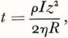
since z = 0 when t = 0. At −20°C. and 1 atmosphere pressure, ρ = 0.0012g./cm.3, R = 9.4 × 10⁻⁷ g./cm.3, η = 1.6 × 10⁻⁴ poise, I = 0.93 g./cm.3, whence
or, if t sec. = T yr. and z cm. = Z m.,
The deepest measured depth of dry till will set a minimum to the time which the moraine has had to lose its ice. From the data in Figure 8, showing an ice-free depth of 7.7 m., one obtains the value T = 75,000 yr. It thus appears that this moraine was deposited at least 75,000 yr. ago.
Discussion
Examining the assumptions made above:
-
i. It is unlikely that the mean annual temperature has been appreciably higher than at present during the last 75,000 yr. (Reference SchellSchell, 1961; Reference HollinHollin, 1962) but, if the local temperature follows global sea-temperature fluctuations as closely as continental temperatures elsewhere, then it has probably been about 4°C. lower during the greater part of the last 100,000 yr. (Reference EmilianiEmiliani, 1958). An increase of 8°C. in local temperature would double the vapour pressure of the ice and hence halve the time required to remove it.
-
ii. A rise of 20°C. in mean annual temperature would be necessary to melt ice from within the moraine. Changes in atmospheric pressure could cause movement of water vapour within the moraine body but the presence of fine till would discourage turbulent mixing. The effective depth of till would be reduced by a factor equal to the maximum fractional change in atmospheric pressure, perhaps w per cent (Scott Base barometric records, 1958–62).
Wind would not be likely to affect more than the upper few centimetres of till.
-
iii. A second-order approximation to the solution of the diffusion equation shows that the error in T, resulting from the assumption of a linear variation in vapour density, is of the order R/3I = 0.00043, which is, for present purposes, negligible.
-
iv. The cover of till above the ice at any one time will increase the effective vapour diffusion distance, thus increasing T.
-
v. The annual surface temperature variation will affect only the top 1 or 2 m. to slightly reduce T, but at greater depth the temperature variation will be unimportant and it is this lower zone which primarily determines T. During the 1964–65 summer the writer nowhere observed thawing of permafrost at a depth exceeding 0.7 m.
-
vi. The mean annual humidity in Wright Valley has not been measured. However, crystals of CaCl2.6H2O normally occur on rocks around Don Juan pond in the south fork of the valley (personal communication from K. B. Popplewell) and it may therefore be deduced that the mean relative humidity is less than 40 per cent. Also, Reference Ragotzkie and LikensRagotzkie and Likens (1964) have shown that under typical conditions the frequent katabatic winds blowing down Wright Valley from the polar plateau will have a relative humidity of about 13 per cent.
From these figures it seems that the mean relative humidity may be about 25 per cent. If so, the time required to diffuse ice from the moraine would be increased to about 100,000 yr.
-
vii. The rate of heat supply required to provide the latent heat of vaporization of the ice is less than that available from the normal geothermal gradient.
-
viii. Examination of moraines around present-day glaciers in the McMurdo region shows that many of them are ice-cored. The presence of an ice core would increase T considerably. Also, the possibility of ice entering the layer of shattered rock beneath the moraine while the latter was forming cannot be discounted, although under present-day conditions water would freeze within a few feet of the surface and form an impermeable layer.
It is interesting to compare the minimum age of 75,000 yr. with another source of information. Consideration of the total salt content of Lake Vanda, the present rate of salt supply by the Onyx River, and the maximum possible inflow rate as deduced from the highest observable shore marks and present ablation rates, indicates a minimum accumulation time of about 60,000 yr. (personal communication from A. T. Wilson).
A glacier travelling eastward through Wright Valley would have to be several hundred metres thick near Lake Vanda in order to cross the rock threshold at the seaward (eastern) end of the valley (Reference BullBull, 1960). It is likely that such a glacier would destroy the moraine discussed above, as well as removing all salts from the lake. This implies that no major through-glacier has occupied Wright Valley during the last 75,000 yr., and in particular that the valley was not inundated by ice during the Northern Hemisphere glaciations of the last 40,000 yr. (cf. Reference WilsonWilson, 1964).
From these facts and the known height of the rock thresholds at the western end of the valley (Reference BullBull and others, 1962) it should also be possible to place an upper limit on the local height of the polar plateau during the last 75,000 yr.
Conclusions
-
i. Seismic P-wave velocities in frozen grounds of the McMurdo Sound region vary from 3,000 to 4,300 m./sec., covering the range for ice (3,650–3,800 m./sec.), and therefore buried ice cannot be idengified by seismic velocity measurements.
-
ii. Surface velocities in unfrozen till, loess and silt varied from 300 to 1,500 m./sec., and in fractured granodiorite from 1,500 to 2,500 m./sec. Massive granite showed a velocity of 4,700 m./sec. Depths of 3.4 and 7.5 m. were determined for accumulated exfoliation debris on a granite outcrop in Taylor Valley.
-
iii. A moraine on the floor of Wright Valley was found to be free of ice to depths of 5 and 7.7 m. Beneath this was a layer at least 10 m. thick, probably consisting of fractured granite. The absence of ice from the moraine suggests that it was formed at least 75,000 yr. ago, implying that the valley was not inundated by ice during the Northern Hemisphere glaciations of the last 40,000 yr.
Acknowledgements
The work described above was carried out during the ninth Victoria University of Wellington Antarctic Expedition in the 1964–65 summer, and was supported by the New Zealand University Grants Committee and the Victoria University of Wellington Research Committee.
I should like to acknowledge the invaluable field assistance of members of the expedition, who generously gave time from their own projects to help move equipment and carry out measurements, particularly W. M. Prebble (leader), R. A. Hoare, J. W. Cole, A. N. Baker, M. F. Schafter and Dr. D. Zimmerman; and many helpful conversations with Dr. D. A. Christoffel, Dr. P. P. Vella, Mr. R. H. Wheeler and Professor A. T. Wilson.
I also wish to thank the Antarctic Division, New Zealand D.S.I.R., personnel of the U.S. Navy, U.S.A.R.P., and Scott Base, for their help.


