


Introduction
Most glaciers in mountainous regions of the world have receded substantially during the last 100 years, probably in response to climatic warming (Reference Hansen and LebedeffHansen and Lebedeff, 1987; Reference Houghton, Jenkins and EphraumsHoughton and others, 1990). Today, surfaces of alpine glaciers lie below Little Ice Age trim lines and their termini, in many cases, are up-valley of Little Ice Age end moraines.
In the Saint Elias Mountains of southeast Alaska, northwest British Columbia and southwest Yukon Territory, recent deglaciation has been accompanied by destabilization of formerly ice-covered, steep rock slopes, mass wasting of drift and increased sediment supply to streams issuing from glaciers. In addition, significant isostatic rebound is occurring in areas where ice losses have been particularly large, for example, some inlets and bays in southeast Alaska (Reference Hicks and ShofnosHicks and Shofnos, 1965; Reference Hudson, Dixon and PlafkerHudson and others, 1982). Furthermore, Reference Meier and PostMeier (1984) has suggested that the melting of glaciers outside Greenland and Antarctica accounts for one-third to one-half of the observed rise in sea level in the 20th century and that more than one-third of this meltwater has come from glaciers in the mountains bordering the Gulf of Alaska.
This paper documents an example of historic, large-scale deglaciation in the Saint Elias Mountains of British Columbia and Alaska, specifically in Melbern Valley and Tarr Inlet (Fig. 1). The documentation is based largely on an analysis of late 19th and early 20th century survey data (International Boundary Commission, 1952), inspection of aerial photographs taken in 1979 and 1987, and field work conducted in 1991. In addition, we explore an analogy between deglaciation of this area over the last few hundred years and the disappearance of the Cordilleran ice sheet at the end of the Pleistocene.
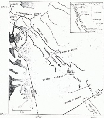
Fig. 1. Map of the study area showing the extent of glaciers in the 1970s, prior to the formation of glacial Lake Melbern (cf. Fig. 2). The Little Ice Age limit is indicated by thick solid lines. The dotted line marks the ice divide at Grand Pacific Pass and arrows indicate ice-flow directions. Topographic profiles AA′, BB and CC′ are shown in Figure 5.
The Grand Pacific Glacier—Melbern Glacier System
Grand Pacific Glacier, with a length of 55 km and width of 2–5 km, is one of the largest valley glaciers in British Columbia (Fig. 1). It flows north and east from source areas at 1500–3000 m elevation in the Saint Elias Mountains near the British Columbia-Alaska boundary and bifurcates into two large ice tongues at Grand Pacific Pass. One of the tongues, Melbern Glacier, flows 20 km northwest towards Tatshenshini River and presently terminates in a glacial lake at about 250 ma.s.l. The other tongue, Grand Pacific Glacier proper, terminates at tide water in Tarr Inlet, 18 km southeast of Grand Pacific Pass.
Decay of melbern glacier
A conspicuous vegetation trim line and associated fresh lateral and end moraines delineate the margins of Melbern Glacier at the maximum of the Little Ice Age. At that time, Melbern Glacier terminated about 15 km northwest of its present position, was confluent with its two largest tributaries, Konamoxt and Tikke Glaciers, and was 300–600 m thicker than today (Fig. 1). A comparison of the extent of the glacier at that time, in 1908 when Melbern Glacier was photographed during an international boundary survey (Figs 2 and 3) and in 1991, indicates that at least 50 km3 of ice has been lost in Melbern Valley north of Grand Pacific Pass in the last few hundred years.
Fig. 2. Part of an international-boundary survey map (International Boundary Commission, 1928) showing the approximate extent of Melbern Glacier in 1908 (cf. Fig. 1). Comparison of this map and a 1908 photograph of the same area (Fig. 3) suggests that Melbern Glacier may not have extended quite as far north in 1908 as is shown on the map, i.e. part of the glacier terminus immediately south of Tatshenshini River, which is shown on the map as being debris-covered, may have disappeared before this date. Map reproduced by permission of International Boundary Commission (1928).

Fig. 3. Melbern Glacier in 1908; view to the southeast from a ridge near Alsek River. At this time, the debris-covered northern margin of the glacier was less than 2 km from the Little Ice Age end moraine. Note, however, that the surface of Melbern Glacier is well below the conspicuous Little Ice Age trim line (arrow). (Photograph by G. White-Fraser (photograph station CYR; #46); courtesy of International Boundary Commission, Ottawa, Canada.)
Thinning and retreat since the Little Ice Age maximum is recorded by a classical staircase-like series of kame terraces and kame deltas along Tikke Creek (Figs 4 and 5) and by shore lines and thick drift which are particularly prominent on the northeast side of the valley below Pentice Ridge (Fig. 1). As deglaciation progressed, lakes were trapped between Melbern Glacier and the walls of the valley; the level of these lakes fell as the glacier thinned. Kame terraces and deltas were built below Tikke Glacier as it separated from Melbern Glacier and retreated eastward. Successively lower terraces record progressive thinning of Melbern Glacier and the related fall in the level of the ice-marginal lake in this area.

Fig. 4. Oblique aerial photograph, taken in 1991, of a flight of kame terraces and kame deltas along Tikki Creek east of Melbern Glacier; view east from above Melbern Glacier. These land forms record down-wasting of Melbern Glacier since the early 20th century.

Fig. 5. Topographic profiles across Melbern–Grand Pacific Valley showing thinning that has occurred between the maximum of the Little Ice Age (surface 1) and 1979 (surface 2). The upper limit of the Tikki Creek kame terraces and kame deltas on profile BB′ is indicated by an arrow. See Figure 1 for the locations of the profiles. Sources of information: 1979 ice surface —1:50000 scale topographic maps derived from 1979 air photographs; Little Ice Age maximum — trim line on 1979 air photographs.
Air-photograph analysis indicates that, shortly before 1979 (Fig. 6a), the lower part of Melbern Glacier stagnated, floated and began to disintegrate into complex tabular masses of ice enveloped by the waters of what were soon to become one of the largest glacial lakes on Earth (“glacial Lake Melbern”). By 1987, the front of Melbern Glacier had receded 7 km and glacial Lake Melbern covered 12 km2 of the valley bottom behind the stagnant toe of Konamoxt Glacier (Figs 6b and 7).

Fig. 6. Aerial photographs of Melbern and Konamoxt Glaciers in (a) 1979 (A25292–183; Energy Mines and Resources Canada) and (b) 1987 (BC87076–268; Province of British Columbia). Note that glacial Lake Melbern is just beginning to form in 1979 as dead ice between the two glaciers floats and breaks up. The lake is fully developed in 1987, although it is charged with tabular icebergs up to 200 m across.

Fig. 7. Glacial Lake Melbern, July 1991; oblique aerial view to the south from the vicinity of Konamoxt Glacier. The conspicuous shoreline about 35–40 m above the lake shore dates to the late 1970s.
Glacial Lake Melbern overflows along the northeast side of Konamoxt Glacier into Tatshenshini River. Initially, the lake was 40–50 m higher than the flood plain immediately below the Konamoxt Glacier ice dam. Between 1979 and 1987, however, the level of the lake dropped due to retreat of Konamoxt Glacier and related incision of the outlet; in 1991, the lake was only 10–20 m higher than the downstream end of the overflow channel. With any further retreat, the lake will cease to be dammed by Konamoxt Glacier but will extend another 8 km northward to the head of Melt Creek (Fig. 1), attaining an overall length of 15 km. Thereafter, the level of the lake may gradually drop as the outlet stream incises the morainal and alluvial plain sloping north to Tatshenshini and Alsek Rivers.
Decay of grand pacific glacier
Historic decay of Grand Pacific Glacier has been documented by explorers and visitors to Glacier Bay (see Reference CooperCooper, 1937; Reference Field and FieldField, 1975; Reference PowellPowell, 1980; for reviews and references). A large piedmont glacier filled Glacier Bay in 1794 when Captain George Vancouver surveyed the Pacific coast of North America (Fig. 8). This glacier was fed mainly by tongues of ice flowing down Muir and Tarr Inlets. The ice tongue in Tarr Inlet comprised a greatly expanded Grand Pacific Glacier and several large tributary glaciers (Margerie, Johns Hopkins, Lamplugh, Reid, Carroll and Rendu Glaciers). Between 1794 and the mid-1800s, Glacier Bay became deglaciated and the ice tongues in Muir and Tarr Inlets separated and began to retreat as independent entities (Fig. 8). In 1879, the ice tongue in Tarr Inlet terminated at the south end of Russell Island and could be properly termed Grand Pacific Glacier. Grand Pacific Glacier retreated 16 km to near the British Columbia–Alaska boundary between 1889 and 1912, and, in the process, lost contact with Margerie Glacier, the last of its Alaskan tributaries (Figs 8 and 9). It re-advanced c. 1 km in 1912–13 and, since then, has fluctuated in a complex fashion, with the terminus located within 2 km of the international boundary.

Fig. 8. Historic deglaciation of Glacier Bay and its inlets. Reference Brown, Meier and PostBrown and others (1982); and references therein. 1860 it Data sources: Reference CooperCooper (1937); Reference Field and FieldField (1975); Reference PowellPowell (1980); æ margin is approximate. A is the viewpoint of Figure 9.

Fig. 9. The terminus of Grand Pacific Glacier (centre of photograph) in the vicinity of Russell Island in 1894 (see Figure 8 for location). View north-northwest from a ridge east of Reid Glacier (bottom left); Johns Hopkins Glacier is at the centre left, and Russell Island abuts the toe of Grand Pacific Glacier at the right. (Photograph by A.J. Brabazon (photograph station King; #77); courtesy of International Boundary Commission, Ottawa, Canada.)
Based on air-photograph analysis, we estimate that approximately 100 km3 of ice have been lost from Grand Pacific Glacier between its present terminus and Grand Pacific Pass in the last few hundred years. A much larger volume of ice, estimated at 250–400 km3, disappeared from Tarr Inlet and upper Glacier Bay between 1860 and 1912, and an additional 100 km3 of ice also have been lost from Johns Hopkins, Queen and Rendu Inlets during and following this period.
Rapid deglaciation in this region has had important geomorphic and other effects. The upper Glacier Bay-Tarr Inlet area is presently being uplifted at rates of up to 3 cm year−1 due, at least in part, to the loss of ice during the last 200 years (Reference Hudson, Dixon and PlafkerHudson and others, 1982). In addition, large amounts of unvegetated drift on recently deglaciated slopes in Melbern-Grand Pacific Valley are now being rapidly redeposited by mass wasting and fluvial processes along the margins of the glacier. Locally, steep rock slopes in this valley and along Tarr Inlet have cracked, sagged and slumped due to the loss of buttressing ice.
Discussion
Causes of retreat
This paper has shown that two glaciers which share a common accumulation area, namely land-based Melbern Glacier and tide-water Grand Pacific Glacier, have had markedly different histories of retreat (Fig. 10). Glacier Bay and Tarr Inlet were deglaciated mainly in the 19th century, a time when Melbern Glacier was relatively stable and extensive. In contrast, much of the retreat of Melbern Glacier occurred during the 20th century.

Fig. 10. Graphs summarizing the retreat of Melbern and Grand Pacific Glaciers since the mid-1800s. Data sources as in Figure 8, plus air-photograph observations and International Boundary Commission records.
Climatic warming in the last two centuries may be involved in the retreat of Melbern and Grand Pacific Glaciers but it does not explain their asynchroneity. Indeed, much of the retreat of Grand Pacific Glacier occurred prior to the warming of the late 1800s and early 1900s, and since 1912, the glacier periodically has advanced in spite of pronounced warming during the periods 1910–40 and 1975 present (Reference Hansen and LebedeffHansen and Lebedeff, 1987).Such asynchronous retreat has been noted in other studies of glaciers in the region (e.g. Reference MannMann, 1986) and has been predicted on theoretical grounds (Reference MercerMercer, 1961). The retreat of Grand Pacific Glacier was driven by calving in the deep waters of Glacier Bay and Tarr Inlet (Reference Brown, Meier and PostBrown and others, 1982; Reference Powell, Milner and WoodPowell, 1988). Calving is a complex process that is controlled by non-climatic factors (Reference Meier and PostMeier and Post, 1987). Calving rates of tide-water glaciers are high in deep water, generally exceeding ice flux to the terminus. Under such conditions, a glacier will retreat to a new equilibrium position, commonly a pinning point where water is shallower or the calving front is narrower, causing ice flow to accelerate. Grand Pacific Glacier attained such a position in 1912, with a relatively narrow calving front and probably a shallower grounding line.
During retreat, the average surface gradient of Grand Pacific Glacier increased south of Grand Pacific Pass. This may have shifted the ice divide between Grand Pacific and Melbern Glaciers northward, routing more ice southward from Grand Pacific Pass towards Tarr Inlet. There is, in fact, evidence for a recent shift in this ice divide. The Little Ice Age trim line of Grand Pacific Glacier between Grand Pacific Pass and the head of Tarr Inlet is 400–800 m above the present glacier surface. It increases in elevation south of Grand Pacific Pass, indicating that the ice divide was farther south at the maximum of the Little Ice Age than at present (perhaps in the vicinity of Ferris Glacier; Fig. 1), Presumably, as the ice divide moved north, less ice flowed into Melbern Valley, causing Melbern Glacier to retreat. Recession of Melbern Glacier was therefore delayed until after Grand Pacific Glacier equilibrated to its new calving-front position.
Analogy with late pleistocene deglaciation
Recent deglaciation of Melbern Valley is analogous to deglaciation of mountain valleys throughout British Columbia at the end of the Pleistocene (c. 14–10 ka BP). Melbern Valley is rapidly becoming deglaciated by thinning, stagnation and frontal retreat. The same style of deglaciation has been inferred for the end of the Pleistocene from studies of sediments and land forms in southern and central British Columbia (Reference FultonFulton, 1967, Reference Fulton1991). Complex valley fills deposited at the close of the last glaciation and consisting largely of thick, ice-marginal and proglacial lacustrine and fluvial sediments (Reference Ryder, Clague and FultonRyder and Clague, 1989; Reference Ryder, Fulton and ClagueRyder and others, 1991; and references therein) are similar to those that have accumulated in Melbern Valley during this century. Likewise, raised deltas and kame terraces identical to those in Melbern Valley are common late Pleistocene land forms throughout British Columbia. Even the scale of the recent and ancient deposits and land forms is similar: well over 100 m of 20th century, ice-marginal sediments are present on the southeast flank of Pentice Ridge and west of Tikke Glacier, and the Tikke Creek terraces extend through a vertical range of more than 350 m.
Similarly, historic deglaciation of Glacier Bay and Tarr Inlet is probably comparable, both in style and scale, to deglaciation of the coast of British Columbia at the end of the Pleistocene (e.g. Reference ClagueClague, 1985). In both instances, glaciers retreated rapidly by calving, probably triggered by climatic warming. About 14 000 years ago, tongues of ice rapidly retreated across the British Columbia continental shelf to pinning points in fiords where they temporarily stabilized (Reference ClagueClague, 1985). Similarly, most of Glacier Bay was rapidly deglaciated in the 19th century, but ice margins stabilized and even advanced in some tributary fiords such as Tarr Inlet in the 20th century.
Finally, an analogy may also be drawn between the rapidity of late Pleistocene deglaciation and the recent retreat of Melbern and Grand Pacific Glaciers. Although the chronology of the advance and retreat of the Cordilleran ice sheet is not known in detail in most areas, available evidence suggests that individual valleys became ice-free rapidly at the close of the Pleistocene, probably over a period of several decades to a few hundred years (Reference ClagueClague, 1986). The Grand Pacific-Melbern Glacier system has lost over 300 km3 of ice, or more than 50% of its mass, in the last 200 years, most of this in the last 100 years. This may be comparable to rates of ice loss in Cordilleran valleys at the end of the Pleistocene.
Acknowledgements
We are grateful to Madame S. Jacques, International Boundary Commissioner (Canada), for allowing access to Commission documents. C. Gustafson (International Boundary Commission, Canada-United States) assisted in locating key historical documents that contain information on the former extent of Grand Pacific and Melbern Glaciers. Reviews by R. M. Koerner (Geological Survey of Canada) and D. R. MacAyeal (University of Chicago) greatly improved the paper. This is Geological Survey of Canada Contribution No. 12592.
The accuracy of references in the text and in this list is the responsibility of the authors, to whom queries should be addressed.


