


Introduction
The glaciological work described in this paper was carried out while the author was employed as senior meteorologist by the Falkland Islands Dependencies Survey at Hope Bay (lat. 63° 24′ S., long. 56° 59′ W.), Graham Land during the period December 1957–April 1960.
The major part of the study was in the immediate vicinity of Hope Bay, where accumula. tion and ablation studies, and observations on ice movement were made on the ice piedmont between Hope Bay and Trepassey Bay and on Depot Glacier (Fig. 1). Accumulation studies by means of digging pits and ice movement observations were also made on sledge journeys down the east coast of Trinity Peninsula, where the main centres of study were the Victory and Russell East Glaciers.
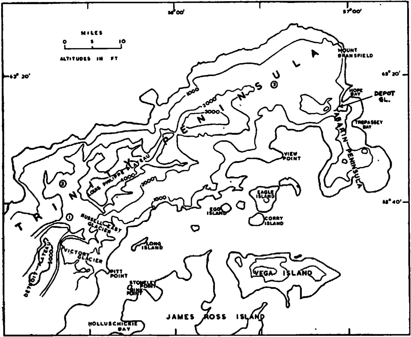
Fig. 1. Map of fart of Trinity Peninsula showing localities where glaciological observations were made. The circled numbers (1, 2 and 3) refer to cairns studied for rime ice and fog deposit accumulation
Trinity Peninsula (Fig. 1), the northernmost part of the Graham Land peninsula, lies north of lat. 64° 15′ S. Morphologically it is composed of east and west coast ice piedmonts separated by the Louis-Philippe and Detroit Plateaux both of which rise above 1, 000 m. The continuity of the plateau surface is broken in three areas, the most important of which (the junction between Russell East and Russell West Glaciers) formed the centre of the most detailed pit work. Prince Gustav Channel on the east coast of the peninsula separates Trinity Peninsula from the James Ross Island group, which consists of James Ross Island and seventeen smaller islands, five of which carry active ice caps.
Full meteorological records are available for twelve years between 1945 and 1960 for the Falkland Islands Dependencies Survey station at Hope Bay, but only intermittent records are available for the View Point satellite station (lat. 63° 33′ S., long. 57° 22′ W.) and for areas south of Hope Bay. Average monthly temperatures occasionally rise above 0° C. in the summer months, but summer average monthly temperatures are usually close to and below freezing point. The 12-year mean of mid-winter temperatures at 46 m. above Hope Bay is −11.9° C. but there is a considerable variation in mid-winter temperatures. The east coast is subject to frequent föhn winds and at Hope Bay they were responsible for a record maximum temperature of +14° C. in July 1958. The most important wind in the Hope Bay area is a cold south-south-westerly which can be expected to exceed 25 m./sec. during every month, and gusts over 40 m./sec. are quite common.
Depot Glacier and the Ice Piedmont between Hope Bay and Trepassey Bay
Depot Glacier is a valley glacier 3, 430 m. long and approximately 800–900 m. wide; it has an important tributary valley glacier (Kenney Glacier) and two unnamed tributary cirque glaciers (Fig. 2). The snout of Depot Glacier is grounded at the head of Hope Bay, into which it calves. The climatic firn line is at 300 m. a.s.l. and the equilibrium line in the main valley is at 65 m. a.s.l. (Fig. 3), the great difference in height between the two resulting from the presence of an important area of firn below the main firn line. This subsidiary accumulation area owes its origin to a lee effect as winds descend the steepest slope on the glacier (Fig. 2). A pit dug in this Iee area at 124 m. a.s.l. gave annual accumulation figures for the budget years 1956–57, 1957–58, 1958–59, and 1959–60 of 47.2, 57.0, 65.0 and 48.4 cm. water, respectively. These accumulation figures, which have been correlated with the meteorological records for the Falkland Islands Dependencies Survey station (46 m. a.s.l.) at Hope Bay, suggest that the meteorological conditions of late Summer and Autumn rather than Spring are the most significant factor in determining the state of the budget. The greatest variation in ablation conditions occurs in Spring and Autumn rather than in mid-Summer, for which 12 years’ records show a uniformity of conditions.
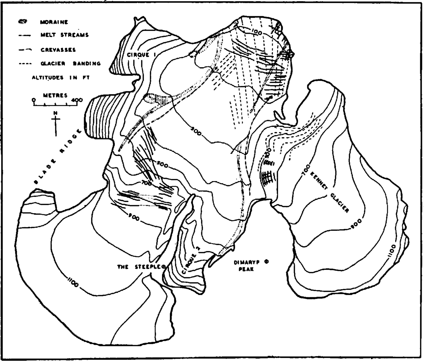
Fig. 2. Map showing the morphology of Depot Glacier, Hope Bay area (after R. R. Kenney (1955) with minor local modifications)
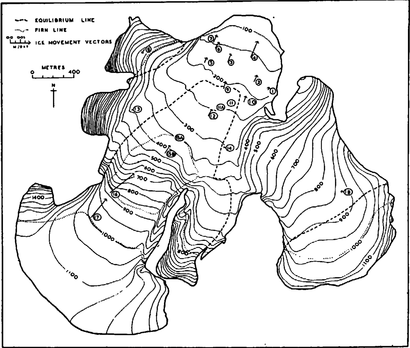
Fig. 3. Budget regions and ice movement on Depot Glacier. Altitudes are given in feet
In the Summer of 1959–60 the ablation sequence on this glacier was observed at six stakes; two stakes below the firn line linked the records with the preliminary observations of 1958–59. The first fact which emerged from these measurements was that the formation of superimposed ice takes place during warm spells of föhn weather in the Winter, mainly when the glacier tongue has a thin snow cover. Figure 4, which illustrates the progress of the ablation season during 1959–60, shows that snow accumulation invariably interrupts the ablation season and reduces the amount of ablation that can take place. Superimposed ice formed again at the end of the ablation season both by the refreezing of melt water running from above the firn line and by the refreezing of snow melt and rain, which fell during short warm spells alternating with cold weather at the approach of Winter.
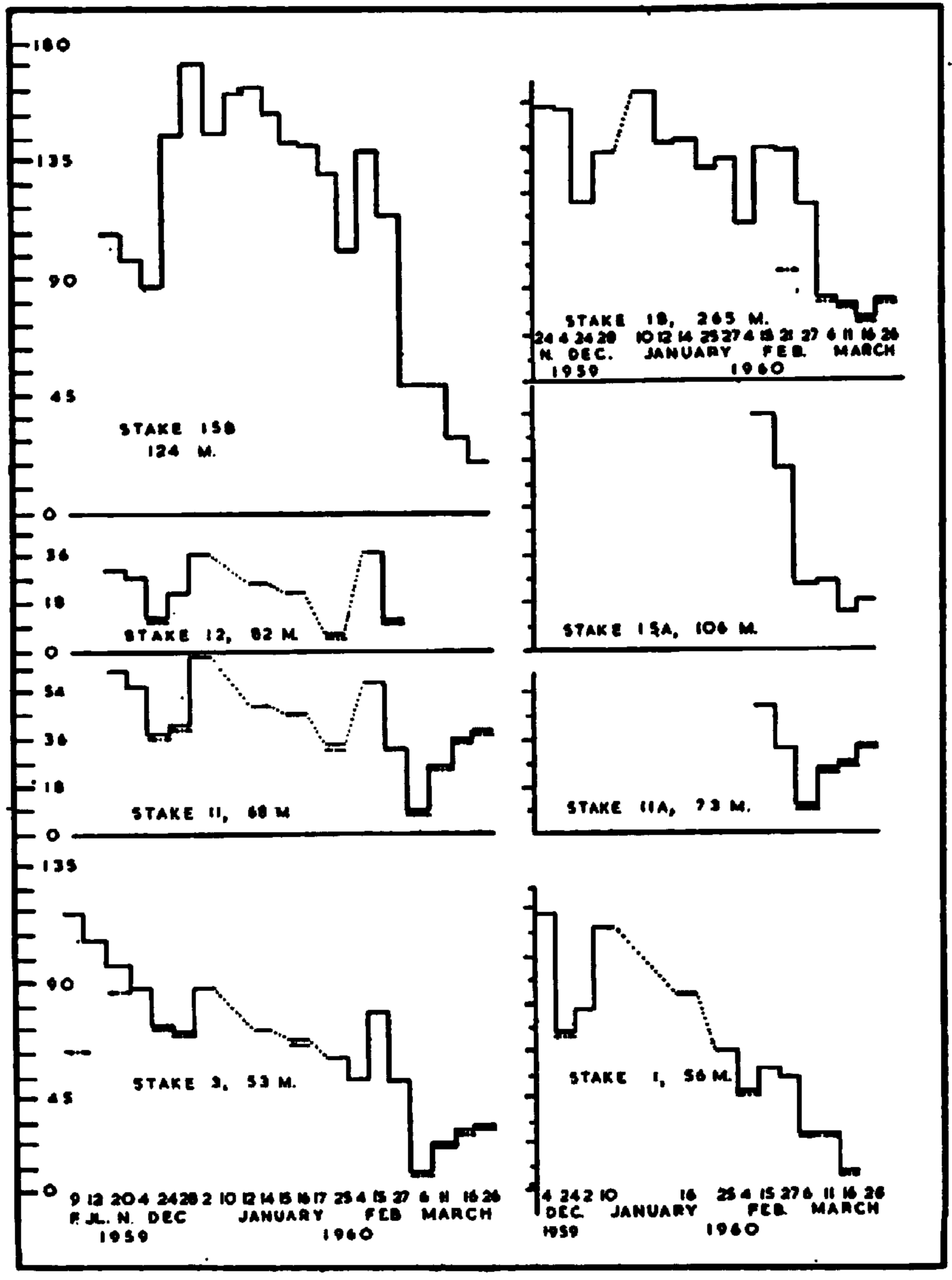
Fig. 4. Accumulation and ablation measurements for Depot Glacier, February 1959—March 1960. The ordinate scale is in centimetres. All the changing snow and ice levels are relative to the initial measurement in the first bar of each graph. The dash-dot-dash line is the level of superimposed or glacier ice whether it is at the surface or under a snow cover
Movement studies over two and a half years (Fig. 3) showed a 50 per cent increase in the summer rate of flow near the centre of the glacier but no variation was detected 50 m. in from the margin of the glacier.
The abstract of the 1959–60 budget given in Table I is only approximate, because several unknown correction factors have not been taken into account. The amount of ice lost at the glacier snout by calving has been calculated graphically from plane table maps of the snout made during the Summer (there was no calving in the Winter of 1959, as evidenced by the unbroken nature of the sea ice in front of the snout) and a cross-section of the sea bed in front of the snout. In this calculation it was assumed that the snout calves to the same degree over the frontal area, from the glacier surface to the glacier bed below sea-level but, in fact, this is not likely to be so, because of the decrease in movement rate with depth.Reference Nye 1 , Reference Perutz 2 In order to calculate the volume of ice, moving through a cross-sectional line at the climatic firn line, that would be in agreement with the state of equilibrium (which will be explained later as applying to this glacier) of the glacier and the observed accumulation figures, it is necessary to assume a considerable decrease of velocity with depth. This means that the purely graphical calculation of ice lost by calving must introduce an error.
Table I. Budget of Depot Glacier, 1959–60
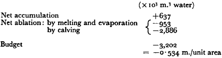
Another unknown factor is the amount of surface melt water retained by crevasses. Meltwater streams flow on Depot Glacier for only about two weeks each year and these run into the series of crevasses about 400 m. from the snout. It therefore seems very doubtful whether any melt water reaches the sea. On Kenney Glacier, which contributes more than half of the glacier network’s total gross ablation because of its north-westerly aspect, melt water flows only in very small quantities onto Depot Glacier or onto a nearby moraine. Although many of the crevasses were filled by melt water towards the end of the ablation season, it is highly unlikely that crevasses would retain the entire gross surface ablation and a proportion must inevitably be lost by evaporation. Evaporation is strongly favoured by föhn conditions, when temperatures exceed 4° C. and relative humidities are usually between 50 and 70 per cent (relative humidities of 20 per cent have been recorded occasionally and 8 per cent has also been recordedReference Pepper 3 ).
The 1959–60 ablation season was unusually warm and contrasted sharply with the cold ablation season of 1958–59 when the snow line only occasionally rose above sea-level. For purposes of comparison, the snow line at Wilkes Station, East Antarctica, was 350 m. lower in 1958–59 than in 1957–58.Reference Hollin and Cameron 4
The measurements given in Table I are therefore probably an exaggeration of the 1959–60 budget and of the average annual budget of Depot Glacier. Photographic evidenceReference Nordenskjöld and Andersson 5 indicates that Depot Glacier is in a state of near equilibrium (see Fig. 5, p. 1069); this is also supported by a sketch map made by Duse in 1903Reference Nordenskjöld and Andersson 5 and by plane table maps of the glacier snout drawn in 1945,Reference James 6 1955,Reference Kenney 7 1957,Reference Herbert 8 1958,Reference Herbert 8 1959,Reference Koerner 9 and 1960.Reference Koerner 9 These show that there was very little change between 1903 and 1945 but between 1945 and 1960 there was a recession of 75–90 M.(±10 m.).

Fig. 5. The snout area of Depot Glacier showing the crevassed area and lateral moraines; viewed from the east at the southern end of Scar Hills. 10 February 1960
Ablation studies on the ice piedmont between Hope Bay and Trepassey Bay were more detailed than those undertaken on Depot GIacier, and five stakes situated between 73 m. and 305 m. a.s.l. were visited 35 times between December 1959 and April 1960. Two points of interest in the ablation sequence, apart from two important periods of snowfall, were that refrozen slush raised the ice level at the end of the first ablation period and that the superimposed surface of the previous Autumn and Winter was lowered during the first ablation period beneath a cover of saturated firn. Bare ice was exposed for only eight days during the first ablation period and for 17 days during the second. Between 6 March 1960 and the beginning of the Winter in late March 10 cm. of superimposed ice (refrozen melt water, snow melt and rain) formed. The first winter snowfall was removed by 8 April 1960 during a south-south-west blizzard.
Below 200 m. a.s.l. on the ice piedmont melt streams flow intermittently throughout the ablation season but the release of a large part of the summer ablation melt water on the northwest-facing slope above Hope Bay depends on slusher bursts (Fig. 6, p. 1069) similar in character to those which have also been observed in north-east Greenland,Reference Lister and Hamilton 10 North East LandReference Glen 11 and Baffin Island.Reference Ward and Orvig 12 These break out whenever a warm period of weather coincides with a snow cover of more than 15 cm. depth. The slashers drain the more Ievel surface above 130 m, a.s.l. and remove the entire snow cover in their path. Slusher bursts occurred on five separate days in the three Summers between 1957 and 1960, and on each occasion they were the main factor in reducing the surface below 200 m. a.s.l. to bare ice.

Fig. 6. The path of a Blusher burst on the ice piedmont near Hope Bay, showing the exposed superimposed ice surface in the bed of the Blusher stream. 21 July 1958
The movement velocity of the ice piedmont is of a very low order: at 200 m. from the ice front the rate was found to be 0.004 m./day and at a height of 200 m. a.s.l. no movement could be accurately detected over a three-month period; at 270 m. a.s.l. the rate was 0.014 m./day and at 305 m. a.s.l. it was 0.028 m./day. The increased rate of flow at the two higher positions resulted mainly from the slight channelling of ice.
The ice piedmont between Hope Bay and Trepassey Bay has a very inactive regime and its specific budget for I959–60 was calculated as −5 cm. of water. The stake profile used for these observations was situated on a north-west-facing slope and, since the Summer was unusually warm, it is almost certain that in a more normal year the annual budget would be even closer to a state of equilibrium, which is supported by photographic evidence.Reference Nordenskjöld and Andersson 5
Using a combination of Perutz’sReference Perutz 13 and Nye’sReference Nye 14 laws for glacier flow, ice thicknesses have been calculated both for Depot Glacier and the ice piedmont between Hope Bay and Trepassey Bay. On Depot Glacier the thickness below 150 m. a.s.l. was calculated as approximately 550 m. but over the greater part of its area the thickness of the ice piedmont is only 50 m., and 140 m. where the ice is channelled. The ice piedmont is clearly a relict feature and is a survival from before the most recent general ice recession.
Trinity Peninsula and the James Ross Island Group
From the amount of icefree ground on James Ross Island it is clear that there is a precipitation shadow effect on the east coast of Graham Land. The west coast of Trinity Peninsula and Joinville Island are usually cloud-covered for the greater part of the year and the precipitation is higher than on the east coast where there is a föhn effect on westerly winds. Sledge journeys have been made from Hope Bay to Mount Bransfield (756 m.), west of the ice piedmont at the northern end of Trinity Peninsula, and also to the Russell West Glacier, which lies in the moist west coast climatic region. The formation of rime ice and fog deposit was found to be of outstanding importance on the west coast, where every nunatak is clad in thick masses of rime. These rime ice masses protrude in immense heart-shaped lobes facing the north-west (or windward) direction. (Figs. 7 and 8, p. 1070). From time to time they break away from the rock face and are incorporated in the glacier ice below. One of these rime ice blocks found at the foot of a north-west-facing ridge of Mount Canicula measured 20 m. by 4 m. by 4 m. Little evidence for rime accumulation on horizontal surfaces was found and measurements of rime formation on glacier surfaces and on vertical stake surfaces gave a ratio of 1 : 40. Layers of rime ice were detected in pit profiles but their contribution to the budget was insignificantly small. The main effect of rime and fog deposit is to settle any newly fallen precipitation and thereby prevent drifting by wind action.

Fig. 7. Rime ice lobes facing the windward (north-west) direction below Mound Canicula at the head of Russell East Glacier (750 m, a.s.l.). 18 October 1959

Fig. 8. A 75 ft. (22–9 m.) high lobe of rime ice near Sirius Knoll (900 m. a.s.l.), Trinity Peninsula. 20 September 1959
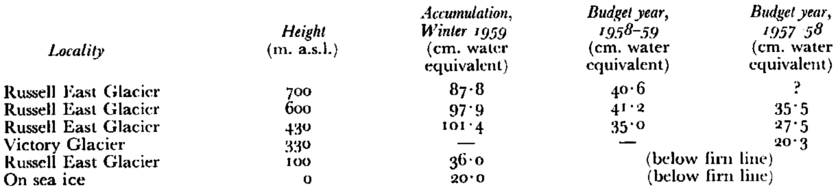
On the east coast of Trinity Peninsula accumulation by arien deposits is insignificant but accumulation by the drifting of snow from higher to lower altitudes, where higher temperatures reduce the ability of the snow to drift, is important. As a direct result of this, the winter accumulation for 1959 was greatest at the lowest of the three pit sites (400 m. a.s.l.) on Russell East Glacier, but accumulation for the budget years 1956–57, 1957–58 and 1958–59 it was highest at the intermediate site (533 m. a.s.l.). Accumulation values are given in Table II.
Table II. Accumulation on the East Coast of Trinity Peninsula
Several 2 m. deep pits dug into the 1959 winter snow revealed ice layers below approximately 300 m. a.s.l., but above this height they were uncommon. However, ice layers were present in a pit dug at about 1, 000 m. a.s.l. on the Louis-Philippe Plateau in the 1959–60 Summer. Although non-freezing temperatures are uncommon above 400 m. a.s.l. in Winter (according to sledge party meteorological reports), the formation of melt water occurs at all altitudes in Summer. Melt water and ice layer formation on the west coast of Trinity Peninsula above about 700 m. a.s.l. results mainly from radiation, freezing rain and the release of latent heat from the formation of rime ice. During the long periods spent at these altitudes the temperature rarely rose above 0° C. even when the temperature at sea-level on the east coast was as high as 6 to 7° C.
An interesting pit profile at 350 m. a.s.l. on Victory Glacier showed 117 cm. of dense firn lying directly on banded ice, in which blue, bubble-free ice alternated with white, bubbly ice. An 8.4 cm. layer of dense firn separated the four bands of superimposed ice from dense glacier ice. This profile has been interpreted as indicating a fairly recent fluctuation and elevation of the firn and equilibrium lines so that the pit site now lies in the névé region of Victory Glacier. The irregularity of the climatic firn line is indicated by the fact that a pit on the same glacier at 300 m. a.s.l. showed a normal profile for the névé of a glacier and no superimposed or dense ice layers were found.
Accumulation studies on Tabarin Peninsula showed that the climatic firn line was at about 300 m. a.s.l., but below that height over most of the peninsula (with the exception of the ice piedmont between Hope Bay and Trepassey Bay) bare ice was never exposed during the two and a half years’ investigations in the area. The snow depth in October 1959 at a representative site 300 m. a.s.l. was only 39 cm. but at a similar altitude in mid-December 1959 it was 42 cm. A cover of snow remained throughout the following Summer, although it was one of the warmest on record. This effect can be attributed both to accumulation by snow drifting from higher to lower altitudes and also to summer snowfall.
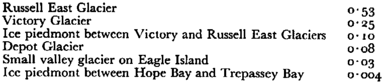
From the study of 30 pit profiles it has been concluded that the whole of Trinity Peninsula lies below the dry snow line, above which no melt occurs;Reference Benson 15 the saturation line, above which melt does not percolate through more than the current budget year’s accumulation is at approximately 650 m. a.s.l. The climatic firn line is below 150 m. on the west coast of Trinity Peninsula, at 230 m. on the east coast, at 300 m. in the Hope Bay area and above 300 m. on the islands in Prince Gustav Channel and on the west side of James Ross Island. Movement studies carried out on Russell East Glacier, Victory Glacier, the ice piedmont between the latter two glaciers, and on a small valley glacier on Eagle Island have confirmed the decrease in glacierization with increasing distance from the central plateau of Trinity Peninsula (Table III). The movement stake profiles, except that on Victory Glacier, were placed about 800–1, 500 m. from the snout of each glacier, and in each case the angle of surface slope was similar.
Table III. Comparison of Rates of Ice Movement (m./day)
Glacial History
Studies of glacier regime, the mapping of glacier snouts and photographic evidence all show that there has been no major recession of the ice piedmonts and valley glaciers of Trinity Peninsula during the present century. However, in considering the Larsen Ice Shelf this is not so. In the Summer of 1957–58 it receded as far west as Cape Longing and in 1958–59 there was further recession when approximately 450 km.2 broke out from the thinner part of the ice shelf north-east of Cape Longing and a similar amount broke away south of Cape Longing.
The icefree enclave (Fig. 9, p. 1071) bounding the south-east shore of Hope Bay and covering 2.8 km.2 is littered with angular, frostshattered debris, much of which has been derived from Mount Flora. Almost all this material is superficial morainic debris, representing frost-shattered rock which has fallen onto the glacier surface. In fact, all the glacier moraines observed on Trinity Peninsula are entirely superficial. Glacial striae, truncated spurs and a glacial overflow channel all suggest that the ice surface of Depot Glacier was at least 150 m. thicker in the past. The submarine topography of Hope Bay indicates that Depot Glacier once extended into Hope Bay where it joined the more active Arena Glacier. It was itself joined by an extended Kenney Glacier and a marginal glacier at the foot of the north-facing slope of Mount Flora.
The Mount Flora cirque glacier is fronted by three successive moraines, two of which are ice-cored and are both composed of continuous lateral moraines and separate 6–15 m. high ice-cored mounds of cobbles, boulders and blocks. The two most recent moraines are 200–225 m. apart and the oldest is a further 400 m. downslope.

Fig. 9. View of the ieefree area south-east of Hope Bay and the margin of the ice piedmont from the upper dopes of Mount Flora. The hummocky ground in the middle distance is fanned of old moraine from the Mount Flora cirque glacier.11 February 1959
Gullying of the rock walls adjacent to Depot Glacier and the broadness of the valleys which carry the intermittent summer melt streams (which now flow on an ice surface for a large part of their courses) suggest a pluvial interglacial. The truncation of the lower parts of inter-gully ridges has given a tentative dating immediately preceding the glacier advance which formed the intermediate of the three Mount Flora moraines.
Striae and glacial erratics on an icefree area 27 km. south of Hope Bay, on Long Island and on the James Ross Island group indicate a glacial stage where mainland ice was at least 300 m. thicker. At that time ice from the mainland filled Prince Gustav Channel and encroached onto the lower slopes of the west coast of James Ross Island where mainland erratics have been found.Reference Bibby 16 Prince Gustav Channel, which formed an outlet for ice both from the mainland and from James Ross Island, was filled with ice to a height of at least 300 m. a.s.l. Since this major glacial stage there have been only relatively minor advances and retreats represented by the Mount Flora moraines and also by a series of seven cirques formed on islands of the James Ross Island group. These are quite well developed and all except one have a base level at approximately 30–40 m. a.s.l. The presence of a small amount of dead ice in several of the cirques and a glacier with a slightly positive budget in another cirque suggest that they are relatively recent features indicative of a firn line below 30–40 m. a.s.l. (raised beaches on either side of Prince Gustav Channel point to recent uplift so that the cirques were probably formed at a lower position than their present base level).
Conclusions
In Trinity Peninsula there is a general decrease in glacierization from north-west to southeast, resulting mainly from the precipitation shadow effect of the central plateau area. The budgets of the glaciers which have been studied are near to equilibrium and the slightly more active regime of west coast glaciers is probably compensated for by an increased amount of calving at their snouts. Glacier regime is largely dependent on summer and more particularly autumn meteorological conditions. An increase in the frequency of föhn winds is also accompanied by an increase in ablation. The most recent glacial recession, during which the Mount Flora cirque retreated from its youngest moraine, may have been a consequence of a shift in the track of depressions affecting Graham Land. In northern Graham Land the movement of depression tracks is mainly southwards but also eastwards, therefore the more the depressions follow a southerly track in the Weddell Sea, the greater the likelihood of an increase in the frequency of föhn winds. While this would have the tendency to promote glacial recession on the east coast, it would not have the same effect on the west coast where westerly winds bring orographic precipitation. In fact, on the west coast of Trinity Peninsula there is no evidence for a recession contemporaneous with the most recent one of the east coast.
Acknowledgements
Thanks are due to all personnel at the Falkland Islands Dependencies Survey Hope Bay station for their general assistance in the field during 1958–60, and especially to D. McCalman who encouraged the author to carry out the work presented in this paper.


