


Introduction
Numerous studies old and new have been devoted to the Greenland Ice Sheet. Of all these that of Loewe is the most remarkable.Reference Loewe 1 It was based on a collection of all the data available in 1936 on the accumulation and ablation of the different zones of the ice sheet. The surface data were taken from the Danish map of Greenland at 1:5,000,000 on which he had traced the edge of the ice sheet.
Loewe’s work now needs to be repeated using new data. We possess to-day in the 15 sheets of the American World Aeronautical Chart 2 a source of geographic information of the first order that supersedes the Danish map of Greenland. 3 The American maps have the advantage that they give details of the contact between the ice sheet and the ice-free land; and they have contours at every 1000 ft. (305 m.). Further, even if Expéditions Polaires Françaises had not from 1948 to 1951 produced data on accumulation and ablation capable of modifying Loewe’s mean values, it is still true that numerous flights over all Greenland have given us a greater knowledge of the outflow glaciers than was possessed twenty years ago—knowledge of fundamental importance in evaluating the balance of the ice sheet.
1. New Geographical Data
The 15 sheets of the American map allow us to make a new determination of the following quantities:


Fig. 1. Limits of the Greenland Ice Sheet
We thus deduce the following facts:
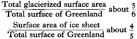
Following the limits of the ice sheet was found to be difficult, particularly for the central part of the east side; Fig. 1 shows the parts neglected. However, contrary to all other authorities, we have considered that the whole of Kong Christian den IX Land, south of Scoresby Sund, and the regions to the north and south of it, ought to be included in the ice sheet. These are accumulation areas of the ice sheet, even though numerous nunataks pierce the surface, and outflow glaciers from the ice sheet traverse them.
2. Hypsometric Curve of the Ice Sheet
We have measured the areas between the contour lines of the sheets of the American map 2 with a planimeter. This gives us the following results:

The data in this table allow us to draw the hypsometric curve of the ice sheet (Fig. 2, p. 459). We have taken 3300m. as the maximum height, a value that was measured once barometrically (uncorrected) at lat. 72° 00’ N., long. 37° 30’ W. by Expéditions Polaires Françaises in 1951. This figure may therefore be somewhat too large; if we take account of this, we see that our hypsometric curve is more regular than that of Loewe.Reference Loewe 1 Further, between the maximum altitude and 7000 feet (2135 m.) it is practically linear; it cannot therefore be likened to a parabola as MeinardusReference Meinardus 4 assumed.

Fig. 2.
The curve allows us to determine the mean height of the ice sheet; it is 7000ft. or 2135 m., as compared to the 2100 ft. of Loewe.Reference Loewe 1
3. Normal Area Distribution Curve
We have divided the altitude variation of the ice sheet into ten parts, and have read off from the hypsometric curve the percentages of the area between these contours. The accuracy of this determination is high, as the 1000-ft. contours are close to these at tenths of the total height.
Percentages taken from the hypsometric curve (Fig. 2) for intervals of tenths of the altitude
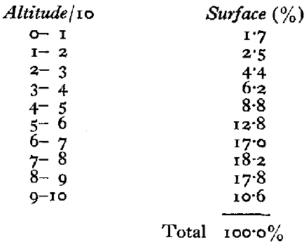
The percentages of total area have been plotted against the altitude in units of total height/10 in Fig. 3 (p. 460) taking care to use a scale in which altitude/10 and 6 per cent are of the same magnitude, and we have thus obtained the normal area distribution curve for the ice sheet.

Fig. 3.
This method of procedure is that which allowed AhlmannReference Ahlmann 5 to obtain characteristic curves for the different glacier types, whatever their configuration. These “normal curves” allowed him to establish a new classification of glaciers. With the normal curve which we have obtained the ice sheet fits well into the Ahlmann classification, being of the type “Inland Ice and Glacier Cap.”
There are several other classifications of glaciers, but the Greenland Ice Sheet never quite fits into them. To quote but one example, it only fits imperfectly into the classification of Wright and Priestley.Reference Wright and Priestley 6 We cannot thus but commend the Ahlmann classification which is the one into which, for the first time, the Greenland Ice Sheet enters.
4. The Firm Line of the Ice Sheet
Using all the literature cited by LoeweReference Loewe 1 and also the observations of Expéditions Polaires Françaises, 7 we have adopted a firn line for each sheet of the American map.

The corresponding areas are:
These figures allow us to determine the mean firn line of the ice sheet, using the hypsometri curve (Fig. 2). Its altitude is 4560 ft. (1390 m.).
5. The Discharge from Glaciers in the Form of Icebergs
To evaluate the discharge from glaciers in the form of icebergs, we have adopted the following procedure. Starting with the existing literature on the different glaciers which flow from the ice sheet, with the American map, 2 the maps at 1:250,000 of the Danish Geodetic Institute 8 and with the map of Paul Emile Victor (Fig. 4, p. 461), we have made a list of all the Greenland glaciers draining ice from the ice sheet. For those glaciers for which neither speed nor outflow are known, we have determined the length of the front, and where possible the thickness of the front, from the depth of the fjord near the front, following BoydReference Boyd 9 From the speeds measured on various glaciers such as Eqip Sermia,Reference Bauer 10 we have taken speeds of 3 to 10 m. in 24 hours for the active glaciers, less than 3 m. in 24 hours for stationary glaciers, and 30 m. per year for dead glaciers from our measurements on Nunap Kigdlinga. 11 These latter velocities have also been taken for the parts of the ice sheet discharging into the sea, as occurs in Melville Bay and south of Angmagssalik.

Fig. 4. Glacier geography of Greenland (after P. E. Victor)
This method gave us the following results:
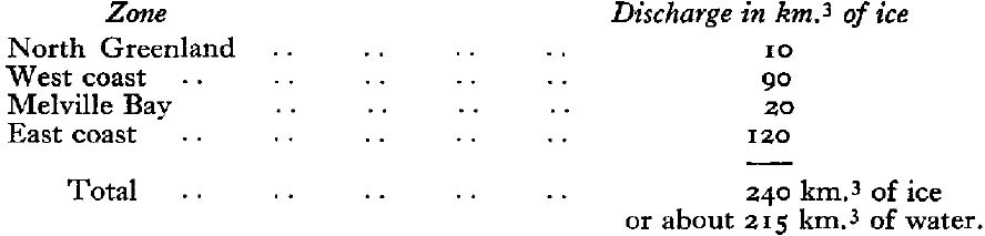
As the edge of the ice sheet (Fig. 1) in the east of Greenland extends to the neighbourhood of the coast, we had to take account of almost all the coastal glaciers. It is worth remarking that our figures show that the discharge from glaciers in the form of icebergs is practically the same on the east coast as on the west, contrary to general belief.
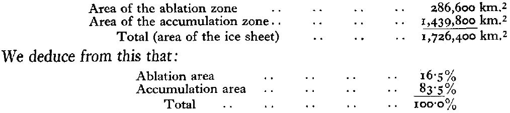
6. Balance of the Ice Sheet
We have adopted Loewe’s figures for the mean ablation (1.1 m. of water) and for the mean accumulation (0.31 m. of water) for the whole of the ice sheet. We thus find:
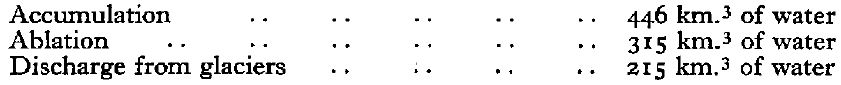
giving a deficit of about 100 km.3 of water per annum.
LoeweReference Loewe 1 came to the conclusion that the ice sheet was stationary; our value for the discharge from glaciers (215 km.3) is larger than his (120 km.3), which is the reason for our negative balance.
It must be remembered that all these figures are known only with very low accuracy, as a small error in the mean ablation and accumulation is multiplied by a very large factor.
One should add that because the accumulation area (83.5 per cent) is much larger than the ablation area (16.5 per cent), the glaciers of the ice sheet must be very sensitive to fluctuations in accumulation.


