


Introduction
Research across Europe and beyond is increasingly revealing ever greater diversity in the form and use of hillfort sites that challenges traditional urban-centric perspectives (e.g. Jia et al. Reference Jia, Betts, Doumani Dupuy, Cong and Jia2018; Arkush & Ikehara Reference Arkush and Ikehara2019; Erb-Satullo & Jachvliani Reference Erb-Satullo and Jachvliani2022; Moore & Fernández-Götz Reference Moore and Fernández-Götz2022; Moore et al. Reference Moore, Hoppadietz, Wendling and Winger2023; Rönnlund Reference Rönnlund2024). Yet, research on the hillforts of Italy and other Mediterranean regions lags behind. Here, interpretations of hillforts, dating to mid/late first millennium BC, typically assume that these large, monumental fortified sites were places of habitation, set on a trajectory towards full urban status and form (Guidi Reference Guidi2008; Scopacasa Reference Scopacasa2015: 165–8). This is especially evident in studies of hillforts associated with the Samnites, a large pre-Roman group of upland Central Italy best known through the accounts of Roman authors for their conflict with the expanding Roman Republic during the latter half of the first millennium BC (Scopacasa Reference Scopacasa2015: 57–64). Compared to Roman urban sites, Samnite hillforts have seen comparatively little archaeological investigation. Consequently, there is a pressing need for new empirical data to support or refute the dominant interpretative models for these sites.
The emphasis on monumentality and urban-centric models has led previous research on Samnite hillforts to concentrate on the excavation of a few large hillforts, such as Monte Vairano (De Benedittis Reference De Benedittis2017) and Monte Pallano (Faustoferri & Lloyd Reference Faustoferri and Lloyd1998; Faustoferri & Riccitelli Reference Faustoferri, Riccitelli, Attema, Nijboer and Zifferero2005). Although these investigations have revealed some urban traits dating to the second and first centuries BC—therefore after the Roman conquest—there is a lack of compelling evidence for such urban status beforehand. Most importantly, this focus on a small number of large sites has resulted in the neglect of systematic research on the several hundred smaller and medium-sized hillforts (<40ha) scattered across Samnium. Typically, the interpretation of these sites has been influenced either by the considerable area enclosed by their stone fortification walls and the significant monumentality of these walls, or by their location in remote mountain contexts, rather than by any evidence of occupation or use (Oakley Reference Oakley1995). Consequently, interpretations often rely on generalisations: those sites located in areas perceived as marginal, such as at high elevations in the central Apennines, are usually interpreted as temporary refuges; while those at lower altitudes, particularly those in the Apennine foothills of Tyrrhenian Italy, are typically viewed as permanently occupied settlement sites with year-round habitation (Bradley Reference Bradley2000; Fontaine Reference Fontaine, Bartoloni and Michetti2013). The monumental walls are typically referred to as ‘fortifications’, a term retained here for ease though the implicit assumption of defence in the term should be noted. Research in neighbouring regions of Italy such as Abruzzo, Lazio, or Basilicata highlights the diversity of the hillfort phenomenon, calling for caution in the application of cross-cultural generalisations (e.g. De Cazanove Reference De Cazanove2008; Stek Reference Stek2009; Fontaine Reference Fontaine, Bartoloni and Michetti2013; De Cazanove et al. Reference De Cazanove, Féret and Caravelli2014; Gualtieri Reference Gualtieri2020; Bourdin Reference Bourdin and Stek2021). Targeted investigations of smaller and medium-sized hillforts are therefore essential in order to understand the occupation or use of these sites and to assess how general models of urbanism might apply to Samnite hillforts.
Systematic investigations on Samnite hillforts on the Adriatic side of the Apennines have been carried out in Molise (Stek Reference Stek2018). Surface and point sampling at larger hillforts, such as Montagna di Gildone (Stek et al. Reference Stek, Hamel, Sánchez and Stek2021), and smaller sites, such as La Romana (Garcia Sánchez et al. Reference Garcia Sánchez, Termeer, Fontana, Kalkers, Stek, Angelucci, Croce, Migliavacca and Saggioro2023), Santa Maria di Loreto and Monte Santa Croce di Cerro al Volturno (Tesse Stek pers. comm.), reveals little evidence for urban traits or dense permanent habitation. However, dense vegetation cover at these sites often hinders the application of other non-invasive methods such as geophysical prospection. It also remains to be determined whether the same forms of occupation at the sites can be observed on the Tyrrhenian side of the Apennines, which, in contrast to the Adriatic side, has traditionally been interpreted as an area of early urbanisation (Fontaine Reference Fontaine, Bartoloni and Michetti2013).
The Ancient Hillforts Survey has recently conducted a systematic exploration of hillforts on both sides of the Apennines (Fontana Reference Fontana and Marchi2022a & Reference Fontanab). The first phase of the project consisted of a lidar-based study of more than 15 300km2 identifying 305 potential sites. Of these, 22 previously known sites and 123 potential sites were selected for ground-truthing. Inspection of these locations verified that 99 of the 123 potential sites are archaeological, of which 70 are previously unknown hillforts, and 45 of which provided evidence for Samnite dating (Fontana Reference Fontana2024). The ground-truthing visits did not allow for an in-depth examination of material cultural assemblages, but a general absence of substantial remains typically associated with permanent habitation, such as structures, building materials and storage vessels, was observed at hillforts on both sides of the Apennines.
One of the most promising sites for further investigation of these questions identified by the Ancient Hillforts Survey project is the Samnite hillfort of Monte Santa Croce-Cognolo. The site occupies a strategic location at a pass formed by the Volturno River, connecting the coastal and inland regions of Campania. This area is traditionally understood as the border between the territories of the Samnites and another pre-Roman group, the Campani. The hillfort encloses 18ha including the twin summits of Monte Santa Croce (580m) and Monte Cognolo (518m), separated by steep slopes descending to a saddle (499m) where a modern-day cemetery is situated (Figure 1). While Monte Santa Croce features a steep and narrow summit with an area of less than 1ha, Monte Cognolo offers a large, gently sloping plateau extending to more than 11ha.

Figure 1. Aerial view looking from west to east showing the site with the plateau of Monte Cognolo in the foreground and the summit of Santa Croce in the background. The village of Villa Santa Croce is on the left (figure by authors).
The highly strategic and defensible location of Monte Santa Croce-Cognolo, its proximity to fertile soils and other natural resources, and the large plateau of Monte Cognolo all suggest that the site was well-suited for permanent habitation and for potential urban development. The presence of the Campanian, and subsequent Roman, city of Capua, 12km away, attests to contemporaneous urbanisation of the area, albeit on a plain and not of Samnite origin (Quilici & Quilici Gigli Reference Quilici and Gigli2004). The considerable labour required for the construction of the fortifications further suggests the presence of a large, organised community (Fontana & Bernard Reference Fontana and Bernard2023). However, previous research has predominantly focused on Monte Santa Croce with its extant walls of polygonal masonry, alongside ruins of a Benedictine monastery, within the Samnite fortifications (Busino Reference Busino, Ebanista and Torili2016). Earlier topographical survey and excavations (Conta Haller Reference Conta Haller1978; Caiazza Reference Caiazza1986; Renda Reference Renda, Gigli and Quilici2004: 368–74, Reference Renda2018) uncovered evidence of permanent occupation on the summit of Monte Santa Croce. This led to the suggestion that it served as an ‘acropolis’ for a hypothesised lower settlement on Monte Cognolo, although the actual presence of the latter, and thus the veracity of this urban-centric interpretation, lacks supporting evidence. The present article assesses this earlier interpretation, using new data to advance an alternative interpretation for the form and use of Monte Santa Croce-Cognolo.
Methods
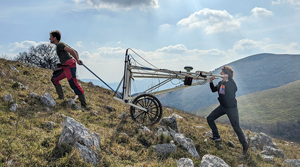
We explored the summit of Monte Cognolo using lidar, multispectral remote sensing, geophysical and pedestrian survey, coring and statistical modelling. The geophysical survey sought to identify buildings, fortifications, anthropogenic deposits and thermoremanent features such as kilns or ovens as indicators of permanent occupation. Previous magnetometer studies on a series of enclosures at a pre-Roman mountaintop site in the Marche region have highlighted the potential of this approach for identifying such features (De Neef et al. Reference De Neef, Frapiccini and Naso2022). To navigate the steep and rocky terrain, we used a mobile cart with four fluxgate gradiometer probes on a lightweight fibreglass frame (LEA MINI system, Eastern Atlas; Figure 2). To complement the geophysical work, we conducted a minimally invasive soil-mapping survey, using an Edelman hand auger equipped with a screw head of 70mm diameter and 250mm length. Coring was carried out on nine selected magnetic anomalies identified during the geophysical survey to gain insights into their nature and to collect information about potential anthropogenic activities.

Figure 2. Top) magnetometry survey at the north-western wall of Monte Cognolo, which is nearly invisible on the ground today; bottom) soil scraping results from animal activities (left) and exposure of soil and bedrock as a result of erosion (right) (figure by authors).
The pedestrian survey covered 11.2ha within the enclosed area on Monte Cognolo, systematically surveying 20 × 20m grids with 100 per cent coverage. The location of each pottery sherd encountered was recorded using GPS, along with its ceramic class (e.g. black gloss) and any relevant observations; no material was collected or removed from the site. Diagnostic pieces were drawn on-site using the method developed for the ground-truthing phase of the Ancient Hillforts Survey (see Fontana Reference Fontana2022b).
The ground surfaces of hillforts and other sites in mountainous locations are typically covered with grass or trees. These variable ground conditions significantly influence visibility. In particular, materials are typically identified in areas of increased erosion, near natural outcrops or in small clearings created by animal activity (such as those caused by wild boar: Figure 2, bottom). Due to the irregular and sporadic nature of these clearings, traditional grid-based recording of visibility conditions is ineffective for modelling purposes. To address this, drone-based multispectral imagery was utilised to create a high-resolution Normalised Difference Vegetation Index (NDVI) map that accounts for actual variability in vegetation cover, with vegetation-free areas taken to indicate high visibility. The map was integrated into a Point Process Model (Baddeley et al. Reference Baddeley, Rubak and Turner2016; Bevan Reference Bevan, Gillings, Hacıgüzeller and Lock2020), along with a Digital Elevation Model (DEM) and an erosion map, to assess the representativeness of distribution of material identified across the site. Full details of the methods, including R scripts and data for the statistical analysis, can be accessed at https://zenodo.org/doi/10.5281/zenodo.8388746.
Results
Fortifications
Analysis of the lidar data significantly changes understanding of the monumental fortification wall enclosing the site (Figure 3), resolving the long-standing debate over whether there was a single circuit (Caiazza Reference Caiazza1986: 249–70) or two separate circuits (Renda Reference Renda, Gigli and Quilici2004: 368–74) enclosing Monte Cognolo and Monte Santa Croce. Our study reveals a single 18ha enclosure that originates from the summit of Monte Santa Croce and takes in the entire plateau of Monte Cognolo. While the stretch of wall around Santa Croce comprises a single stone wall, that enclosing Monte Cognolo shows more varied construction methods, with the southern and western sections featuring an additional rampart. The magnetometry data further confirm the presence of a stone wall along two sections of the southern side of Monte Cognolo and, based on parallel positive and negative anomalies, suggests the stone blocks were extracted on-site (Figure 4 & Figure 5 #1).

Figure 3. Lidar visualisation and interpretation with inset detail of the small southern entrance (figure by authors).

Figure 4. Results of the magnetometry survey. The black dots with white space around them are the results of magnetic anomalies caused by modern metal poles on the top of the hill (figure by authors).

Figure 5. Archaeological features identified on Monte Cognolo, with reference numbers (in white circles) as reported in the text, and the location of cores (yellow circles) (figure by author).
The lidar data reveal a 3m-wide entrance through the wall on the south side of Monte Cognolo (Figure 5 #2). This takes the form of a ‘gateway a baionetta’, with an angled passageway into the hillfort created by overlapping two parallel stretches of the enclosure wall, allowing tight control over those passing through. East of this entrance is a series of localised 30m-long surface depressions between the wall and a modern path above (Figure 5 #3). These depressions coincide with linear magnetic features, indicating the presence of buried stone walls and adjacent fills (Figure 5 #1). A coring sample from this area recovered green glazed medieval pottery, a fragment of tile and worked tuff, suggesting the depressions relate to later (post-Samnite/Roman) activity (Figure 5 core 104).
In the northern survey area, analysis of the lidar data reveals the fortification wall here comprised a single wall without a rampart. The wall runs beneath the forested area of Santa Croce, parallel to a series of cross-channel terraces on the saddle between two summits, serving as the foundation for one of them. Remnants of polygonal masonry aligned with the wall visible on lidar confirm the presence of the enclosure wall, which contrast with the rough stone masonry used for the terrace wall built on top of it and the other terraces parallel to it. For this reason, it is likely that the terraces are to be dated to a later phase of occupation of the site, possibly to the Medieval period. West of this area, we identified a previously unknown entrance opening towards the medieval village of Villa Santa Croce and providing the most accessible point of entry to the summit (Figure 5 #4). The lidar data indicate a path that connects Monte Cognolo and the medieval village, a feature corroborated by present-day inhabitants of the village who report that such a route was in use prior to the construction of the modern road leading to the cemetery. The entrance through the enclosure wall is 15m-wide. Possible terraces delimiting the interior side of the entrance are also visible in the magnetometry data (Figure 5 #5).
Just west of the large entrance, the magnetometry survey detected two roughly parallel curvilinear negative magnetic anomalies, interpreted as stone walls (Figure 5 #6). The northern anomaly was readily identifiable in the lidar data but the southern anomaly could only be detected through a second, more targeted analysis of the lidar prompted by the magnetometry results. Immediately to the south, the magnetometry data also show a curving alignment of positive magnetic anomalies. These anomalies are interpreted as a series of pits and a trench, probably the remains of a structure made from perishable materials (Figure 5 #7).
On the north-west edge of the plateau, the magnetometry survey highlighted a series of irregular linear, mostly negative, magnetic anomalies. These features are orientated north–south along the edge of the plateau. Some could relate to collapsed stretches of the fortification wall, possibly resulting from the later construction of a field system that intersected the circuit (Figure 5 #8). The interpretation of other features, however, is more challenging. Two weak negative linear features with aligned positive anomalies running downslope potentially indicate a passageway leading east, although these traces are not visible in the lidar data (Figure 5 #9). Other linear features exhibit a south-west–north-east orientation.
Just south of the site of the possible wall collapse on the north-west side of the plateau, the pedestrian survey identified remnants of a stone wall (Figure 5 #10) including several in situ courses of blocks visible in an exposed part of the foundation of one of the terrace walls present in the area (Figure 6, top). These stone courses resemble the walls of polygonal masonry found at other Samnite hillforts (Oakley Reference Oakley1995). This resemblance, along with the features identified on the cross-channel terraces, supports the suggestion that later terrace builders, possibly medieval, made use of ancient walls as foundations.

Figure 6. Top) typical wall crown in polygonal masonry identified at the site; bottom) soil column with loamy organic soil extracted at core 105 in the northern area (see Figure 5). No anthropogenic materials were identified (figure by authors).
In summary, although a fortification wall around Monte Cognolo is not readily apparent on the ground, the combined findings from the remote sensing, geophysical and pedestrian surveys confirm the presence of a fortification wall of polygonal masonry with at least two entrances. As elsewhere, the walls will have provided a ready source of stone for later builders, including for the construction of the Benedictine monastery and the nearby medieval village of Villa Santa Croce. Nonetheless, present-day residents of Villa Santa Croce corroborate the survey findings, noting that remnants of the walls on Monte Cognolo were still standing half a century ago.
Internal layout
Lidar and aerial data offer limited insight into the internal layout of the site. Analysis of the lidar data reveals a terrace wall that demarcates the flatter part of Monte Cognolo (Figure 5 #11). Further south, a series of low limestone terrace walls are visible both on the surface, lidar and in the magnetometry data (Figure 5 #12).
In contrast to limited evidence provided by the lidar and aerial imagery, the results of the magnetometry and coring surveys prove more useful for understanding the internal layout. In the southern part of the surveyed area, a linear negative anomaly indicates the existence of a wall (Figure 5 #13), running from south-west to north-east, forming the western boundary of the terraces visible on the surface (Figure 5 #12). An alignment of weak positive anomalies and a series of elongated dipole anomalies suggest another feature delimiting the southern side of the hilltop (Figure 5 #14), interpreted here as part of a timber structure. East of this feature is a rectangular positive anomaly measuring approximately 20 × 22m (Figure 5 #15). It contains a cloverleaf-shaped positive magnetic feature, possibly a pit or dump (Figure 5, #16). The feature might be interpreted as an animal enclosure or perhaps a small stable. Close by, another feature, interpreted as a pit, lies within a circular positive anomaly with a diameter of approximately 7m, suggesting a possible hut (Figure 5 #17). Moving north to the summit of Monte Cognolo, there are several positive magnetic anomalies, although their interpretation is complicated by the presence of concrete and metal wire (Figure 5 #18).
In the central part of the north-west promontory, the survey area is characterised by numerous positive magnetic anomalies (Figure 4). Coring conducted on two of these anomalies (Figure 5, cores 105 to 108) confirms that they are natural karst holes filled with organic deposits mixed with volcanic materials such as pumice, tephra and mica minerals. This fill creates a significant but naturally formed magnetic contrast with the limestone geology.
Materials
The survey identified 645 ceramic sherds, of which 34 were diagnostic (Figure 7; see online supplementary materials (OSM) for detail). The total number of sherds is remarkably low given the extent (11.2ha) of the surveyed area. We tested visibility biases by developing a simple Point Process Model using three variables: elevation, erosion and NDVI. Lidar data were used to produce a DEM, which in turn was used to calculate a simple erosion model incorporating slope length and steepness. The resulting erosion map shows areas of lower erosion with lower scores, with higher scores indicating higher erosion. Drone multispectral imagery was employed to calculate a 35mm-resolution NDVI model, in which areas with low values indicate bare soil, and higher values represent areas with abundant vegetation.

Figure 7. Distribution of artefacts identified during pedestrian surveys (figure by authors).
Figure 8 presents a non-parametric summary of the density of finds in relation to each variable, emphasising the univariate relationship between the presence or absence of finds and the analysed variable at different scales (Baddeley & Turner Reference Baddeley, Turner, Baddeley, Gregori, Mateu, Stoica and Stoyan2006: 179–81). Examining elevation, materials appear to cluster just below the summit of Monte Cognolo, forming a ring within the range of 495–515m. The erosion graph suggests that materials concentrate in areas with lower erosion rates. The NDVI analysis shows a strong tendency for materials to be found in areas with bare soils, indicating regions with good visibility conditions.

Figure 8. Top row) variables implemented in the Point Process Model; middle row) finds density as a function of the different variables; bottom left) smoothed residual field of the fitted model; bottom centre and right) pair correlation function (PCF) of the unfitted and fitted model (figure by authors).
Table 1 presents the results of the regression conducted on the distribution of the finds. Elevation emerges as highly significant in modelling the distribution of materials. Conversely, erosion and NDVI are not statistically significant. This difference is crucial, as it indicates that while there is bias in the availability of materials for collection, the overall distribution of material is not significantly affected and can still be considered representative. This observation was also recently confirmed by a second visit to the site after a wildfire burned all the vegetation. Even in the absence of vegetation, the distribution of materials at the site remained consistent with the analysis above, further supporting the validity of the statistical approach used.
Table 1. Results of the regression analysis conducted on the distribution of finds.

*= p<0.001; n = not significant.
The bottom left-hand corner section of Figure 8 shows that the smoothed residual field (Baddeley & Turner Reference Baddeley, Turner, Baddeley, Gregori, Mateu, Stoica and Stoyan2006: 417–19) of the fitted model effectively captures the distribution of material across most of the site. Exceptions are evident in a few clusters around the summit, with a particularly large concentration to the south. The pair correlation function (Baddeley & Turner Reference Baddeley, Turner, Baddeley, Gregori, Mateu, Stoica and Stoyan2006: 225–29) further confirms the presence of some clusters of materials. Although the typologies of materials shown in Figure 7 are insufficient for interpreting distinct functions associated with these clusters, they represent promising areas for future test pitting.
The ceramic sherds are mostly from skyphoi (drinking cups) and ollae (small jars), which primarily date to the fourth and third centuries BC (Figure 9). The black gloss skyphos sherds have a moderately well-purified, soft and compact, yellow-reddish fabric, and an easily flaked black slip. Due to the generally poor state of ceramic preservation at the site, it is possible that some of the ‘plain ware’ sherds might actually be black gloss sherds that have lost their slip—a common phenomenon in this region. Many of the olla sherds are comparable in form to those found in various Samnite contexts including the large hillfort of Monte Variano (De Benedittis Reference De Benedittis1990), the sanctuary of Campochiaro (Capini Reference Capini1984) and the settlements of Carovilli (Capini Reference Capini1991) and Fonte del Romita in Capracotta (Rainini Reference Rainini1996). In addition, a small number of sherds of cylindrical pots and dolia (large storage vessels) were found, all dating to the pre-Roman period, together with eight sherds of hand-made impastoid pottery of uncertain date. Only a single recognisable coarse-ware sherd attests to a Roman-period presence. A single sherd each of medieval majolica and green glazed ware were recovered, the latter during coring; two tile fragments that may date to the medieval period were also identified.

Figure 9. Sample of diagnostic materials identified during the survey (see OSM for the full assemblage) (figure by authors).
Discussion
Previous research at Monte Santa Croce-Cognolo focused on the summit of Santa Croce. There, excavations yielded roof tiles and dolia of the fourth–third centuries BC suggesting permanent occupation of the site during this period (Conta Haller Reference Conta Haller1978). By contrast, studies on Monte Cognolo have been limited. Here, the absence of an extant fortification wall likely discouraged investigations due to the research interests and biases of Italian settlement archaeology (see Knodell et al. Reference Knodell, Wilkinson, Leppard and Orengo2023). Therefore, the proposition (Caiazza Reference Caiazza1986: 249–62; Renda Reference Renda, Gigli and Quilici2004: 374, Reference Renda2018: 26) that Monte Cognolo formed a residential area linked to the occupation at Santa Croce is entirely speculative and relies solely on the favourable topography of its gently sloping plateau. Our new data challenge this urban-centric interpretation.
The magnetometry data do not reveal any features suggestive of permanent habitation on Monte Cognolo. Rather, the alignments of postholes and trenches that are identifiable in the geophysical results are more consistent with timber enclosures that may relate to activities such as animal husbandry. Smaller, parallel limestone terrace walls on the southern slope of Monte Cognolo suggest crop cultivation and/or erosion management; these may relate to later medieval reuse, as indicated by the ceramic materials collected and coring data from this area.
The artefacts collected during the pedestrian survey of Monte Cognolo also argue against permanent habitation. The prevalence of small cooking vessels and drinking cups is common at other temporarily occupied sites in the region. Moreover, the absence of pre-medieval tile and the recovery of only two storage-vessel sherds sharply contrasts with the abundance of such artefacts from the summit of Santa Croce and at contemporaneous farm sites elsewhere. Moreover, the presence of large, ‘empty’ areas is consistent with other surveys conducted in the neighbouring region of Molise (Stek et al. Reference Stek, Hamel, Sánchez and Stek2021; Garcia Sánchez et al. Reference Garcia Sánchez, Termeer, Fontana, Kalkers, Stek, Angelucci, Croce, Migliavacca and Saggioro2023), as well as with recent findings from hillforts elsewhere in Europe. For instance, a recent archaeobotanical study at the oppidum of Bibracte (France) suggests that large, open spaces within the enclosed area were maintained as grasslands (Hajnalová et al. Reference Hajnalová2023). Consequently, instead of assuming dense, permanent settlement on Monte Cognolo, an alternative interpretation is needed to explain the function of this large and monumental hillfort.
Recent theoretical contributions propose low-density urbanism as a framework for understanding the hillforts of temperate Europe (Moore & Fernández-Götz Reference Moore and Fernández-Götz2022). Low-density urbanism challenges traditional notions of urbanism—which typically emphasise densely populated, nucleated cities with clear boundaries—and instead provides a framework for understanding settlement patterns that are more dispersed, less concentrated and integrated with the surrounding landscape. They posit that habitation could extend beyond the fortifications. Regional archaeological surveys around Monte Santa Croce-Cognolo do not support this, identifying little evidence of substantial nearby settlements (Renda Reference Renda, Gigli and Quilici2004). It is worth noting, however, that these studies mainly surveyed cultivated fields at lower elevations and higher-altitude forested areas, such as that near Villa Santa Croce, remain largely unexplored. To date, lidar interpreted during the Ancient Hillforts Survey (Fontana Reference Fontana2024) has been ineffective at identifying structures in these areas, but future research may be able to provide a clearer picture.
Hence, at Monte Santa Croce-Cognolo possible evidence of permanent habitation is only apparent on the summit of Santa Croce, or an area of 1ha out of a total 18ha across the site as a whole including the steep slopes connecting the two peaks and the 11ha Monte Cognolo plateau. Instead, our findings from Monte Cognolo are consistent with temporary occupation and we suggest that the site may have functioned as a location for animal husbandry, rather than as a permanent settlement. Excavation or test pitting of Monte Cognolo would undoubtedly lead to a better understanding of the nature of Samnite-period activity on the plateau, but our results suggest that such work would be unlikely to detect significant evidence for permanent habitation.
Interviews with residents of the nearby village of Villa Santa Croce provide valuable additional context. Several people recount how, approximately 70 years ago, Monte Cognolo was used year-round for pasturing the village's livestock, including sheep and pigs. Only during particularly warm summers were livestock moved to lower fields north of the village. The area also supported foraging for seasonal flocks of turkeys. While such information cannot confirm the historical continuity of animal husbandry at the site, these ethnographic accounts are noteworthy. They are consistent with the new survey evidence, offering a plausible explanation for the primary use of the site as seasonal and permanent pasturing.
Interpretations focusing on livestock and pastoral economy are largely neglected by the urban-centric perspective that has guided research on Samnite hillforts. This reveals a failure to engage with local oral histories and reflects a somewhat colonialist attitude. Researchers have often approached these sites merely as visitors, without engaging with local communities to enquire about traditional land use and about the social and historical significance that these sites hold. The strong connection between the village of Villa Santa Croce and the hillfort is evident, not least in the buildings of the former that likely incorporate stone blocks sourced from Monte Cognolo. Local accounts, full of childhood memories of tending animals on Monte Cognolo, further affirm this relationship. Following many decades of depopulation and emigration to nearby cities, the recent trend of deurbanisation is now drawing back young people who are keen to revive the community spirit and identity connected with these mountainous areas and with places such as Monte Cognolo. The next phase of the Ancient Hillforts Survey will actively engage with local communities in understanding and conserving these significant sites.
Conclusion
Our non-invasive investigations of the 18ha Monte Santa Croce-Cognolo hillfort in central Italy has revealed a lack of evidence for permanent occupation of the site. Instead, the results point to pastoral activities, compatible with local oral accounts of the recent use of the site for year-round pasturing and seasonal foraging. This new evidence challenges the previous urban-centric interpretation of Monte Cognolo as a permanent habitation site, suggesting instead that its primary function may have been centred around a livestock-based economy. A future programme of test pitting and excavation, paired with an isotopic study of animal remains, may help to validate this interpretation (see Trentacoste et al. Reference Trentacoste2020).
The significance of these findings lies in the exposure of the persistent bias prevalent in previous research. Sites such as Monte Santa Croce-Cognolo, with their strategic locations, monumentality and proximity to areas of fertile soils, have abundant potential for urban development and permanent habitation. But this does not mean that they were used as such. The very limited evidence of residential occupation of the 18ha fortified area of Monte Santa Croce-Cognolo prompts a reassessment of the interpretation of other Samnite hillforts that have been viewed predominantly through an urban-centric lens. Our data suggest that various models of settlement organisation coexisted across central Italy during the latter half of the first millennium BC. This article therefore contributes to the debate on alternative, non-urban forms of social organisation in ancient Italy, the Mediterranean and beyond.
Methodologically, few geophysical surveys have been conducted in Italy's mountainous areas, so our work also contributes to the fine-tuning of survey strategies in highland archaeology (Ullrich & De Neef Reference Ullrich, Neef and Carrer2024). Our strategy of combining the collection and analysis of remotely sensed and field data illustrates the benefit of an integrated and iterative methodology. Through statistical modelling, the study also advances a straightforward yet effective approach to surface visibility in pedestrian surveys and assessment of potential recovery biases in the densely vegetated mountainous regions of central Italy and beyond.
Acknowledgements
We are grateful to Emma Hoffmann, Estelle Fischer, Patrick Rock and, especially, Willem Beekhuis for their contributions to the fieldwork; to Andrew Bevan, Corinna Riva and Tesse Stek for their feedback; to the Royal Netherlands Institute in Rome, the Soprintendenza Archeologia, Belle Arti e Paesaggio per le province di Caserta e Benevento, and especially Ilaria Matarese, for facilitating and supporting the project. We also thank the anonymous reviewers and the editors for their helpful comments.
Funding statement
This work was funded by the UK Arts and Humanities Research Council (grant number 2239341), the UCL Institute of Archaeology and the University of Bamberg. Equipment was provided by the Royal Netherlands Institute in Rome and Ghent University.
Online supplementary materials (OSM)
To view supplementary material for this article, please visit https://doi.org/10.15184/aqy.2024.157 and select the supplementary materials tab.


 Open access