


Introduction
Structural activity relating to human settlement in Garhwal, central Himalaya, emerged around the sixth century BC (Nautiyal & Khanduri Reference Nautiyal and Khanduri1986). The most intensive building activity, however, in terms of temple construction and other architecture began under the Katyuri Dynasty in the eighth century AD. Katyuri rule declined in the eleventh to twelfth centuries AD, leaving a political vacuum that was filled by a noble class, or chiefdoms (Garhpatis), that controlled the minor principalities which emerged in this region (Negi Reference Negi1988: 47). Based on early studies (Kathoch Reference Kathoch1996), the Garhpatis are believed to have constructed around 52 forts (Garh) between AD 1100 and 1500; these protected against threats from other local Garhpatis and foreign invasion. In addition to these forts, other, smaller buildings were discovered on high mountain ridges; these were known as fortalices (Garhi) and acted as watchtowers. While forts served the dual purpose of residence and watchtower, fortalices were used only as watchtowers (Rawat Reference Rawat2017). It was the profusion of forts and fortalices that gave the region its name, Garhwal, which translates as ‘the land of forts’; this was coined in the fifteenth century when the area was consolidated by Ajaypal, thirty-seventh king of the Parmar Dynasty (Raturi Reference Raturi1928: 2). To date, no detailed study has been undertaken to investigate the dual residential and defensive aspects of these medieval forts and fortalices, or to situate them in a chronological framework. This case study on the fort of Chaundkot addresses that lacuna; here we present an investigation into the structural remains of this previously unexplored and important fort located in the southern part of Garhwal to explore its physical extents and fortifications, and to date the fort using radiocarbon assays.
Defensive features: combining architecture and landscape
Chaundkot Fort is located in the Nayar Valley in the Pauri Garhwal district of Uttarakhand state, India (29°58′42.02″N, 78°54′4.31″E) (Figure 1). The ruins of this fort are scattered over a large area of uneven terrain that seems to have been extensively modified. A detailed total station survey shows that the ruins of this fort are spread over three different hillocks of a ridge covering a total area of 46.33ha (Figure 2). On hillock I, large parts of walls, which form rooms that might have been used as a residence for the chief or nobleman, are visible under debris and thick vegetation. The structure appears to have been arranged almost like a cloister, with a square range of rooms on the exterior and an inner central structure, also divided into separate rooms. Little remains visible of the walls of the structure above ground, but these include a main exterior wall and a partition wall in the outer range of buildings, both running in an east–west direction (Figure 3a–b). The southern corner of the large wall had seven surviving courses and stood to a height of 1.37m (Figure 3c). Hillock II on the ridge retains the structural remains of square-shaped rooms arranged in two parallel rows, reminiscent of barracks, running downslope to the south-east (Figure 3d) and suggesting that this hillock might have been used as a residential-cum-military complex. Several single structures exist on the summit of the hillock. On hillock III, which is separated from the others by several manmade ditches, the surviving structural remains occupy a smaller area than those on the two other hillocks, which gives the impression of smaller structure, perhaps an entry point for the fort.

Figure 1. Map showing the location of Chaundkot Fort and its fortalices (figure credit: Nagendra Singh Rawat).
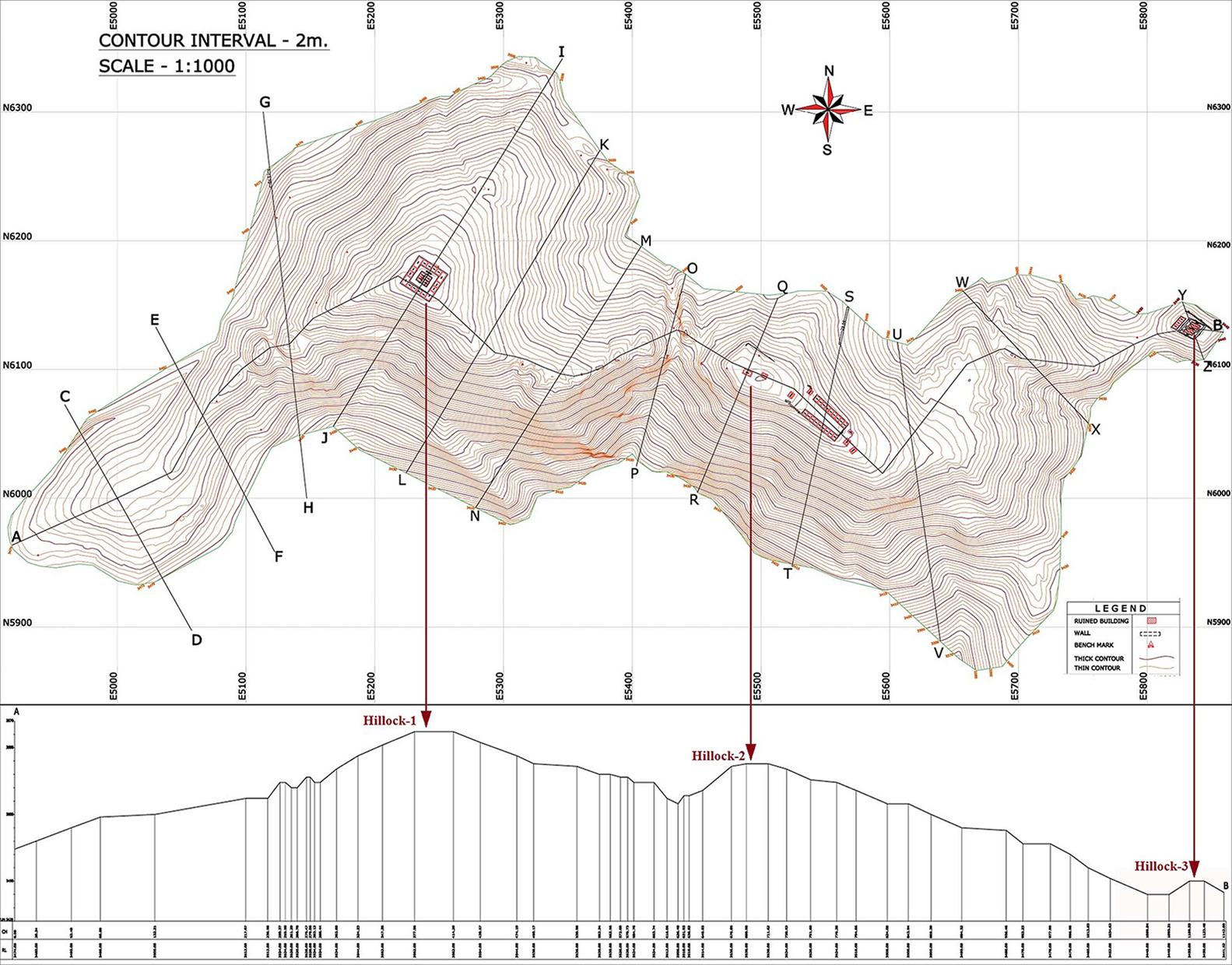
Figure 2. Topographical plan showing the fortified area of Chaundkot Fort along with a section profile (figure credit: Nagendra Singh Rawat).

Figure 3. a) An exposed portion of partition wall; b) an exposed portion of the main wall; c) the base of the wall of Chaundkot Fort; d) the ruins of a series of rooms (figure credit: Nagendra Singh Rawat).
The structural remains of Chaundkot Fort indicate that various ingenious defensive elements were incorporated into its architecture. These include massive fortified walls and an underground tunnel connecting hillock I to a nearby spring flowing away from the fort in a south-west direction, which might have been used as an escape route during an emergency or siege conditions. These defensive features were further reinforced by a series of deep ditches surrounding the fort (Figure 4). In addition, several fortalices, locally known as Kim, Deeba Gurad, Govin and Garhi, serving as watchtowers were constructed within visible range of Chaundkot on nearby mountain ridges (Figure 1). These fortalices must have been used as nodes of communication to alert the occupants of Chaundkot to danger, possibly using smoke, flaming torches or drums (Figure 5). This arrangement of three rings of defence is unique in this region; intervisible fortalices surrounding forts in Garhwal Himalaya seem to have formed a network providing a robust defensive system for Chaundkot (Rawat Reference Rawat2017).

Figure 4. Manmade ditches between hillocks I and II (figure credit: Nagendra Singh Rawat).

Figure 5. Three rings of defence around Chaundkot Fort (figure credit: Nagendra Singh Rawat).
Material culture
The exploration also yielded some large fragments of Red Ware and Black Ware, which mainly represent handi (deep, wide-mouth vessels), bowls and vases (Figure 6a). This particular type of pottery has also been found at the excavated site of Ranihat in Alaknanda Valley, which dates between c. 600 BC and AD 1200 (Nautiyal & Khanduri Reference Nautiyal and Khanduri1991). Other finds include lacquer-embedded glass bangles (Figure 6b) and lacquer beads (Figure 6c), discovered on hillock II. These are interesting and may hint at the importance of the site. Lacquer beads have not been found on any other archaeological site in Garhwal, but are known from various sites in western and central India dating to the fourteenth to fifteenth centuries AD (Ghosh Reference Ghosh1990). These finds suggest a cultural connection between Garhwal Himalaya and western and central India during the medieval period. In addition, the discovery of a brown musket ball on Hillock II (Figure 6d) is important as these have been reported from various sites in India that saw British military activity (Kumar Reference Kumar, Kumar, Rajesh and Abhayan2017). The solitary musket ball from Chaundkot Fort probably came there with the British who were ruling this region in the early nineteenth century.

Figure 6. a) Sherds of Red Ware and Black Ware; b) bangles made from lacquer and glass; c) lacquer beads; d) brown musket ball (figure credit: Nagendra Singh Rawat).
Chronology
In order to determine the date of Chaundkot Fort, several charcoal samples were collected from three different locations and from different contexts within the structure (Table 1).
Table 1. Radiocarbon dates from Chaundkot Fort.

The radiocarbon date for sample 2 (380 BC±80 yr) suggests early occupation activity at the site during the fourth century BC. The radiocarbon date returned for sample 3 clearly indicates that building activity must have commenced at Chaundkot c. AD 910, as this sample was collected from beneath an exposed portion of the floor. These radiocarbon dates enable us to narrow down the chronology of Chaundkot for the first time to between AD 910±60 and 1080±90. Previously, forts in Garhwal were dated very broadly to between AD 1100 and 1500.
Conclusion
The archaeological case study of Chaundkot Fort has revealed new insights into the nature of forts in this region. For the first time, a radiocarbon dating programme has provided a chronology for the construction and use of the fort. The field survey of the structural ruins and dating has provided a better understanding of the system of defence employed by the fort and its fortalices. These include a unique system of three rings of defence consisting of heavily fortified walls, deep ditches and the ring of fortalices surrounding the main fort, which could use visual (flame and smoke) and sonic (drum beats) signalling to provide early warning of attack. This system of defence combining architecture, landscape topography and signalling seems to have been devised for the first time in this region by these medieval chiefdoms in Garhwal Himalaya.
Acknowledgements
Nagendra Singh Rawat would like to thank the Department of History and Archaeology, H.N.B. Garhwal University, for providing help to carry out the fieldwork. The authors also sincerely thank the Director of the Birbal Sahni Institute of Palaeosciences, Lucknow, India, for use of their facilities and permission to undertake radiocarbon dating.


