


Fragments from the past in the forests of Cherangani
Predominantly characterised by a mixture of temperate forest and Ericaceae species growing between 2000 and 3500m asl, the Cherangani Hills form a rolling upland plateau situated in the western highlands of Kenya (Figures 1–2). Previous work across the wider region (Sutton Reference Sutton1973), including in the Kerio Valley to the east (Davies & Moore Reference Davies and Moore2016) and in the Wei Wei Valley to the north (Davies Reference Davies2012), has documented the dynamic history of different Kalenjin populations residing in the area—namely the Marakwet, Sengwer and Pokot—who migrated into the region 200–300 years ago. These communities are southern Nilotic-speaking populations whose ancestors migrated into the Central Rift Valley no later than 1000 years ago in the Late Iron Age (Davies Reference Davies, Mitchell and Lane2013). Associated with this migration is the Sirikwa archaeological tradition, a phenomenon that is characterised by large bowl-shaped earthworks (so-called ‘Sirikwa holes’, commonly interpreted as cattle kraals) and roulette-decorated ceramics.

Figure 1. Location of the Cherangani Hills in north-west Kenya; yellow dots indicate the surveyed earthworks discussed (sources: Project Data & Google Earth; produced by David Kay).

Figure 2. Looking south-west across the highland glades of the Embobut Forest (photograph by Lunn-Rockliffe 2016).
The highland forests of Cherangani potentially play an intriguing role in illuminating the history of Late Iron Age livelihoods, the dynamic interactions between so-called ndorobo hunter-gatherer communities and pastoralists (Sutton Reference Sutton1973), as well as the ethnogenesis of contemporary populations in light of the rapid expansion and subsequent fragmentation of Maa-speaking populations across the region between the seventeenth and nineteenth centuries (Sutton Reference Sutton1973; Davies Reference Davies, Mitchell and Lane2013). Indeed, previous surveys and excavations, most notably those conducted at Kaisungurr (Sutton Reference Sutton1973) and Morpus rockshelters (Davies Reference Davies2012), index a deeper history to the region, where a range of earthworks, lithics, cairns and furnaces offer tantalising insight into past economies, trade networks and identities. Yet unravelling these narratives in more detail is profoundly difficult, not least due to the minimal amount of archaeological work conducted in the region to date.
Thus, in an effort to enrich our understanding of the long-term history of the Cherangani Hills, three extensive field seasons were undertaken in the Embobut Forest between 2016 and 2018. Starting from the present day and working backwards, oral histories were collected in conjunction with participant mapping sessions, archaeological surveys and test-pit excavations. In the first instance, oral histories from Sengwer and Marakwet communities living in the forest attest to their migration into highland glades approximately 250 years ago—aligning with the timeframe set out by previous studies (Davies & Moore Reference Davies and Moore2016). Importantly, oral testimonies mention the remains of populations living in the highland forests prior to the Sengwer's and Marakwet's arrival. Elders recounted finding pieces of pottery that differ in style to their own communities’ typical ceramics (Figure 3), often within the vicinity of intriguing earthworks in the form of circular depressions reminiscent of ‘Sirikwa holes’. Further testimonies recount finding fragments of iron slag in the surrounding hills. Given that local elders have no recollection or knowledge of iron smelting within their own communities’ forest-dwelling histories, this is further evidence that the region retains older archaeological remains than those of its current inhabitants. The question remains as to what these residues are, whether or not they are related to the Sirikwa tradition and what the subsequent implications are for our understanding of Late Iron Age lifeways.

Figure 3. Rouletted pottery found by contemporary populations living in the Embobut Forest (photograph by Lunn-Rockliffe 2016).
Surveys and test-pit excavations
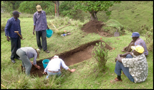
Archaeological surveys were carried out in March 2017 in order to understand the earthworks described by elders in more depth. A total of 72 circular depressions measuring 8–15m across were recorded with a GPS, most commonly located on small plateaux and shallow slopes close to the Embobut River, rather than the steeper slopes that define much of the surrounding topography (Figure 1). In May 2017, it was decided that two clusters of depressions (EMB-17 Lomoi and EMB- 17 Kamoi), and one individual depression (EMB-17 Saniak), should be surveyed and test-pitted. These sites were selected based on local knowledge of areas of minimal cultivation and disturbance, as well as logistical ease of access. Each site was base-line mapped to record the surface archaeological context for each test-pit. Different test-pit strategies were then employed across the three sites. At EMB-17 Saniak, one 3 × 1m trench was laid from the depression's edge towards the centre (Figure 4). At EMB-17 Kamoi, two 1 × 1m test-pits were placed in the centre of two of the four depressions surveyed. Two 1 × 1m test-pits were also dug at the third site of EMB-17 Lomoi—one inside and one outside of a single depression (Figure 5).

Figure 4. Fieldwork team excavating EMB-17 Saniak (photograph by Lunn-Rockliffe 2016).

Figure 5. Completed survey of a cluster of depressions and the location of test-pits at EMB-17 Lomoi (Source: Project Data; produced by Lunn-Rockliffe 2017).
Finds
Very little archaeological material was recovered from these test-pits: one bovid tooth, one ceramic sherd comprising the base of a handle, one fragment of unidentified bone and one undecorated ceramic body sherd (Figure 6). Nor did the trench sections reveal any noticeable stratigraphy beyond seemingly natural forest-soil profiles, although sediment blocks taken for micromorphological analysis and matching bulk sediment samples for geo-chemical analyses may yet produce information not visible during field observations.

Figure 6. Artefacts found in excavations: A) cow tooth; B) pottery fragment; C) bone fragment; D) pottery fragment (Source: Project Data; produced by Lunn-Rockliffe 2017).
Discussion
Few interpretations can be yet drawn about the nature of the Embobut Forest depressions due to the dearth of artefacts found within them. Such a scarcity is puzzling, not least because these bowl-shaped hollows do not appear to be natural—they neither represent the bowls from uprooted trees or sheer planes from landslides. The possibility remains that, although we were informed otherwise, cultivation may have taken place historically across the areas excavated, and thus any artefact-bearing deposits could have been disturbed or removed entirely.
Contextualising these earthworks with oral historical and broader archaeological research from across the region could elucidate their potential usage. Given that Sirikwa-style pottery at Kaisungurr (Sutton Reference Sutton1973) and in the Wei Wei Valley (Davies Reference Davies2012) has demonstrated that the Sirikwa tradition extended into lower parts of the Cherangani Hills, it is possible that the Embobut earthworks are similar to ‘Sirikwa holes’. These hollows are hypothesised to have been semi-defensive cattle kraals, with people living in surrounding dwellings, as evidenced by excavations at Hyrax Hill (Sutton Reference Sutton1987; Kyule Reference Kyule1997). Such remains probably represent communities of mixed agropastoralists clustered together into small lineage-based units, with the defensive nature of the sites pointing towards a time when small-scale cattle raiding was prevalent. The wide geographic extension of the Sirikwa tradition by the middle of the second millennium AD suggests that such communities were socially and economically diverse (Davies Reference Davies, Mitchell and Lane2013). The earthworks in Embobut could thus represent instances where the Sirikwa extended beyond the grassland plains and into the highland forests.
Preliminary conclusions
If the remains in Embobut do belong to the Sirikwa tradition then this further supports the intriguing notion that Late Iron Age agropastoralists were not restricted to more open grassland plains, but also exploited highland forest environments. Yet caution needs to be exercised in jumping to such conclusions—after all most Sirikwa sites display a wealth of archaeological material that simply did not appear in our excavations. Nevertheless, the earthworks surveyed in Embobut clearly point towards an archaeological tradition within the area that pre-dates the arrival of its present-day inhabitants. For the time being we refrain from speculation as to the possible ethnic identity of these inhabitants, although the resemblance to Sirikwa holes is suggestive of their use of cattle for at least part of their subsistence base.
In order to further our understanding of these sites and the relationship that these bear with the surrounding archaeological and oral historical evidence, more research will need to be conducted with extensive excavations undertaken on other, less disturbed, depression clusters that lie deeper within the forest.
Acknowledgements
This research was carried out under Excavation/Exploration Licence number NMK/ACL/k/Vol.1, issued by the National Museums of Kenya (NMK) and held by David K. Kay, and with the assistance of NMK representative Christopher Kirwa. We are grateful to Christopher Kirwa, Lily Rice and Joseph Kimatai for their dedication in undertaking the surveys. We also thank Dorcas Jebet for hosting the team for the duration of the fieldwork. The final excavation report has been deposited with NMK and available from the authors upon request.


