


Introduction
Avalanche hazard maps of high accuracy are difficult to produce. For land-use planning and management purposes, a good knowledge of extreme avalanches and their run-out zones and frequencies is required. In some cases, well-known examples are provided by historical records (Reference Buser and FruttigerBuser and Fruttiger, 1980; Reference Lied and BakkehøiLied and Bakkehøi, 1980; Reference McClung, Mears and SchaererMcClung and others, 1989; Reference Salm, Burkard and GublerSalm and others, 1990; Reference Lied, Weiler, Bakkehøi and HopfLied and others, 1995; Reference AdjelAdjel, 1996; Reference Furdada, Vilaplana, Tomàs and MasFurdada and others, 1998; Jóhannesson, 1998; Reference Barbolini, Gruber, Keylock, Naaim and SaviBarbolini and others, 2000). In the Pyrenees, however, historical data are scarce, difficult to obtain or not very accurate, and sometimes they do not exist at all.
Vegetation and dendrochronological studies have intrinsic value as indicators of mountain ecological conditions. In the present work, vegetation (especially Pinus uncinata trees) is used as a tool that can provide data to characterize avalanches occurring in historical times. These data can help to determine both the extent of large or extreme avalanches and their occurrence in time. Previous works with the same aim are Reference PotterPotter (1969), Reference CarraraCarrara (1979), Reference ButlerButler (1985), Reference Butler and MalansonButler and Malanson (1985), Reference Bryant, Butler and VitekBryant and others (1989) and Reference Pelfini, Santilli, Caccianiga and GironiPelfini and others (2001).
Vegetation was studied at the Canal del Roc Roig avalanche path in Vall de Núria, eastern Pyrenees, Spain (coordinates in Universal Transverse Mercator (UTM) projection, spindle 31, Northern Hemisphere: 429500, 4694500; 431000, 4693500; see Reference Muntán, Andreu, Oller, Gutiérrez and Martı´nezMuntán and others, 2004). It is an east-oriented catchment, drained by a torrent, with a maximum altitude of about 2400 mand an altitude at the bottom of the valley of about 1750 m. The avalanches affect the railway (close to the bottom of the valley) to the Vall de Núria resort and the run-up to the opposite slope. The railway was built in 1929, so there are no historical avalanche data previous to that year. On the other hand, during winter 1996 two important avalanche events affected this path. Data on snow-cover conditions, avalanche characteristics and run-out distances are available for the two events. The avalanche cadastre compiled by the Institut Cartogràfic de Catalunya (ICC, 2002) includes the record of another avalanche that occurred in 1972. These data are compared with the results of the vegetation study in order to test the usefulness of the vegetation data as a guide to the characterization, extent and frequency of large avalanches.
Vegetation Study
The vegetation study consisted of a detailed survey of the avalanche path and the selection of eight transverse profiles, covering a band 4 m wide, at different altitudes on the path (Fig. 1). Along these profiles, structural and quantitative parameters, some of them reflecting damages on trees, were classified, measured and recorded (i.e. dead or living trees, adult trees or young and stressed trees, visible wounds, trunk form, distance to the central stream, diameter at breast height 1.30 m (DBH); Fig. 2). The types of differently damaged trees were also mapped in the field with the aid of aerial photos and orthophotos (Fig.1). In addition, ten 10m×10m parcels, characterized by some floristic homogeneity and avoiding brusque changes related to the substratum and the topography, were selected and an inventory of flora was carried out.

Fig. 1. Map of the vegetation data at Canal de Roc Roig. (1–7) Tree ages: (1) 0–20 years; (2) 21–40 years; (3) 41–60 years; (4) 61–80 years; (5) 81–100 years; (6) 101–200 years; (7) 201–300 years. (8) Trees which show signs in the ring of the 1996 avalanches. (9, 10) Trees whose last growing season was: (9) 1995; (10) 1996. (11) Transverse-profiles location. (12) Dead and transported trees. (13) Dead, not transported trees, presenting wounds. (14) Adult, wounded trees. (15) Adult trees with tilted and curved trunks. (16) Community of Hieracio-Festucetum airoidis Br.-Bl.1948. (17) Canal del Roc Roig avalanche path mapped in the avalanche paths map (ICC, 2000).
Fig. 2. Diagrams of the diameters of the recorded trees at 1.30 m DBH along the transverse profiles, and of the different types of wounds registered on the trees along the transverse profiles. The numbers at the right side of each transverse profile correspond to the numbers of the same profiles mapped in Figure 1.
Adendrochronological sampling campaign was also under-taken. Trees were sampled predominantly close to transverse profiles No. 3 in the track zone and No. 8 in the run-out zone, overlapping the limit of the avalanche path. Tree-ring cores and tree sections and wedges were obtained. The method used is presented in detail in Reference Muntán, Andreu, Oller, Gutiérrez and Martı´nezMuntán and others (2004).
The data obtained from the vegetation and dendrochronological studies are synthesized in Figures 1 and 2.
Avalanche Data
The study path is located in a region with major snowfalls coming from the east. North-to-northwestern winds are dominant, and often follow the eastern storms, redistributing the snow cover (Reference SalvadorSalvador, 1985 ;Reference Mases, Font and VilaplanaMases and others, 1998).
In the case of the Roc Roig path, the prevailing winds are not seriously deflected by local topography, so the northernmost part of the catchment often experiences winter snowdrifts.
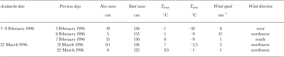
At this path, three large, naturally released avalanches were documented and compiled by the ICC (ICC, 2002; Table 1). The three avalanches reached at least as far as the railway (1745ma.s.l.), and the two occurring during winter 1996 ran about 35–45m up the opposite slope. The nivo-meteorological conditions during the two 1996 events are summarized in Table 2 and Figure 3. These two avalanches are mapped in Figure 4.
Fig. 3. Snow stratigraphic profiles; T: Temperature (°C); H: snow height; F: snow-grains form; ϕ: snow-grains diameter; D: snow hardness (qualitative); U: snow humidity (qualitative); e: snow density. Symbols correspond to the international classification for seasonal snow on the ground (Reference ColbeckColbeck and others, 1990). (a) Snow profile corresponding to the second snowstorm period before the 7–8 February 1996 avalanche. It was recorded at Hostal Pastuira (2020 m a.s.l.), located about 10 km east of Vall deNúria but in the same climatic region. The new snow accumulated during this period was about 100 cm in this location. (b) Snow profile corresponding to the third snowstorm period before the 7–8 February 1996 avalanche. It was recorded at Vall de Núria (2130 m a.s.l.). The new snow accumulated during this period was about 60 cm in this location.
Fig. 4. Map of the avalanche path of Canal del Roc Roig: (1) Canal del Roc Roig avalanche path mapped in the avalanche paths map (ICC, 2000). (2) Avalanche of 7–8 February 1996 (starting-zone limits interpreted). (3) Avalanche of 22 March 1996. (4) Extent of the avalanche path of Canal del Roc Roig due to the vegetation and dendrochronological results. (5) Zone where avalanches of different sizes and direction can occur, from vegetation and dendrochronological results. (6) Zone where very confined avalanches occur, determined from vegetation and dendrochronological results and morphological indices.
Table 1. Natural avalanches occurring at the Roc Roig path compiled in the ICC cadastre
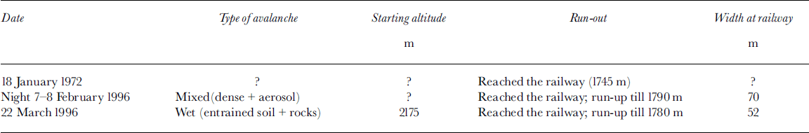
Table 2. Snow and weather data recorded at Núria station (1970 m a.s.l.) related to the 1996 avalanches occurring at the Roc Roig path
Results and Discussion
The comparison of the avalanche and the vegetation and dendrochronological data allows us to outline some results.
In the northern part of transverse profile 1 (Fig. 1 and 2), trees with diameters 515 cm are dominant and reach the watershed. Some of these small trees present an apparently normal growth but are mixed with quite recently wounded trees, some with their main trunk broken, and some in situ dead trees and dead trees that underwent a short transport and indicate the direction of the valley (sometimes they are pulled up and the scar affecting the soil can be seen a few metres above). Fig. 1 and 2 also show trees with inclined and curved trunks. All these damages can be interpreted as the result of an avalanche passage.
It is well known that the distribution pattern of several species (e.g. dwarf-shrub species) is strongly influenced by the distribution of the snow cover (Reference AulitzkyAulitzky, 1963; Reference Grabherr and MucinaGrabherr and Mucina, 1993). A community of Hieracio-Festucetum airoidis Br.-Bl.1948 was identified and mapped above this zone (Fig. 1). In the Pyrenees, this community appears at about 2300– 2400ma.s.l., as in the Roc Roig path, and reaches about 2800–2900ma.s.l. It colonizes flat or slightly inclined zones and is usually covered by snow for approximately 7 months per year (Reference VigoVigo, 1976; Reference FolchFolch, 1981; Reference Boló s, Vigo, Masalles and NinotBolós and others, 1993). In the area, altitude and aspect where this community is mapped, the long durability of the snow cover can only be explained by the existence of snowdrifts. The mapped community is located on a slightly inclined area (slope 10–20°), leeward with respect to the watershed, taking into account the dominant winds, and therefore in a position that favours the formation of snowdrifts. At this altitude of the path, the trees present flag forms (with most branches growing southwards, offering minimum resistance to the wind), which also reflects the dominance of these northerly winds. The regular topography leads to the expectation of snowdrift formation all along the watershed, including the area of damaged vegetation described in the previous paragraph. All this is in accordance with what is known about this zone (see previous section).
Over-accumulation of snow can increase the inclination of the original slope and also favour the release of avalanches. The starting zone of the wet avalanche (22 March 1996) is well known and begins below this area. Themixed avalanche (7– 8 February 1996) occurred after three snowstorm periods followed by strong northerly winds (Table 2; Fig. 3). The starting zone of this avalanche was approximated taking into account all these observations (Fig. 4).
At profile 3, all the northernmost trees show the effects of the avalanches of 1996 in the rings and also typical morphologies due to avalanche events. From these data, two hypotheses can be suggested: (1) that the wounds were caused by a small aerosol component related to the 7–8 February 1996 large, mixed avalanche event; (2) that the wounds were caused by small purges or slides produced in this area related to the high temperatures (Table 2) that triggered the 22 March 1996 avalanche. Until now, it has not been possible to test these hypotheses.
From the distribution of the damaged trees, their ages (Fig. 1) and their recorded diameters (Fig. 2), some morphologic–topographic control of the avalanches can be deduced. In transverse profiles 2–4, the mapped strips of damaged vegetation are separated by smooth topographic arêtes. Profile 3, with the exception of the northernmost trees (see previous paragraph), shows a progressive increase in tree ages from the torrent to the extremes, the youngest trees being located in the zone that tends to channelize the avalanches, closer to the axis of the torrent. This helps to identify the most frequent trajectories of the avalanches. At about 110 m (horizontal distance) north of the torrent, the regular forest begins. The difference in ages between the oldest and some intercalated younger trees is probably due to the internal forest dynamics (normal regeneration).
Along transverse profiles 1–4, the coexistence of damaged and dead trees and trees with curved and inclined trunks can be observed, together with trees apparently not affected. The affected trees can only be detected by detailed fieldwork. Field observation from the opposite slope (which allows observation of the entire path) or the aerial photographs does not clearly indicate all the damages. Other reasons for damages and anomalous growth (e.g. rockfalls or soil creep) are not plausible here. Snow creep could be responsible for some curved trees, but not for all damages
Along the track zone, the dead and wounded trees and the trees with inclined and curved trunks (Fig. 1) indicate that the area affected by avalanches is wider than that mapped by the ICC (ICC, 2000) (Fig. 4). For the track and run-out zone (52200ma.s.l.), the avalanche path mapped by the ICC covers an area of 9.9 ha; the area mapped in the present work is 10.9 ha, which is 10.1% more than the initial area; when all the zone with avalanches of different sizes and difficult individualization is considered, the total path covers 15.4 ha, which is 55% more than the initial mapped area. This shows the importance of detailed studies of vegetation in selected paths. They provide much more valuable information than avalanche maps of scale 1:25 000, made with budget and time limitations.
The records presented (including the two trees whose last growing season was 1996, close to the northern part of profile 3; see Fig. 1) seem to be consistent enough to increase to the north the limits of the avalanche path mapped in the avalanche paths map Núria–Freser (ICC, 2000; Fig. 4). At transverse profiles 5–7, in the lower part of the track and at the beginning of the run-out zones, the tree diameters seem to indicate the topographic control of the avalanches. Trees without apparent damages or anomalous growth can be identified at the edges of the channel; when they have diameters 420 cm they do not coexist with damaged trees. Trees with these diameters grow at the topographic limits of the channel, behind arêtes or topographic inflexions, and are protected from the avalanches. These lateral limits approximately correspond to the limits of both the 1996 avalanches.
From the transverse profiles and the dead surveyed trees, the trajectory of the 7–8 February 1996 large avalanche can be deduced. It descended from the true left side of the torrent (which appears to be the most frequent), crossed it and then descended mostly along the right side (following a zigzag effect). The trajectory was not centred along the axis of the torrent. This trajectory is confirmed by the photographs taken after the event, which showed the main deposit of the avalanche at the right side of the channel.
Some of the dead trees transported to the run-out zone have diameters 420 cm (including some 440 cm). This indicates that the 1996 avalanches affected zones of well-developed trees, not usually affected by these destructive events. Owing to differences in release position, flow direction and the behaviour of individual avalanches, there is an inherent variability in avalanche direction along the path (Reference Keylock, McClung and MagnússonKeylock and others, 1999). Our data reflect the fact that not all the avalanches follow the same trajectory. Although there is an important topographic control in this path (strongly channelized along the track zone and with topographic constraints in the run-out zone), and although most of the avalanches that descend along this path are well-channelized, wet avalanches, and some of them run close to or reach the railway, small deviations along the trajectory occur when, as in this case, a mixed avalanche event occurs. In these cases, old trees can be affected and even broken and transported. Thus, inferences about the exceptionality of avalanches from the age of dead and transported trees should be made carefully. A few very old dead trees could imply just a deviation from the most frequent trajectory, and not always a really extreme avalanche (Reference Muntán, Andreu, Oller, Gutiérrez and Martı´nezMuntán and others, 2004).
From the age of the trees close to transverse profile 8 (Fig. 1) the width of the 1972 avalanche at the railway was approximated to 55–60m. All the trees in the central part of this profile are younger than 40 years, so probably they began to grow after the 1972 avalanche. The trees at the edges of this profile are older than 40 years, so they mark the limit of the 1972 avalanche and they present wounded or tilted trunks. From the ICC cadastre data, it is known that mixed and wet avalanches occurred, but our data do not allow us to determine the type of avalanche. So what type of avalanche occurred in 1972 could not be deduced. This result is in accordance with the fact that avalanches with return periods of some tens of years reach at least as far as the railway (ICC, 2002).
In the run-up zone to the east of the railway, three trees (one Salix sp. and two Pinus uncinata; Fig. 1) show signs of a disturbance coming from the main, opposite slope in 1996: the one located at the southernmost position, the Salix sp., is tilted to the east, the central one shows signs affecting the tree rings, and the main trunk of the northernmost one was broken in 1996. These data correspond well with the observations of the 1996 avalanche deposits. This result shows the value of the dendrochronological studies.
Conclusions
We want to point out the usefulness of vegetation and dendrochronological studies. They help to characterize the most frequent distribution of the snow cover, and thus potential starting zones of avalanches; the vegetational communities reflect the durability of the snow cover and the snowdrifts that protect them. Adding this information to knowledge of the climatic characteristics of the region and observations of topography, roughness and inclination of the slopes, it should be possible to identify more accurately the potential starting zones of avalanches.
Also, these studies can be used to better understand the trajectories, run-out zones and frequencies of avalanches in a given path. With the scope of land-use planning, the vegetation and dendrochronological studies can help to identify the most frequent run-outs and to simulate avalanches more realistically when there is a lack of historical data to calibrate the dynamics models.
Acknowledgements
We are grateful for the collaboration of Vall de Núria mountain and ski resort, and the financial support of the following projects: RISKNAT (SGR2001 00081); MICYT: REN2000-0518; ALUDEX (MICYT-FEDER: REN2002-02768); and Programa Ramón y Cajal (Res. 20/12/2001).


