


Introduction
The southernWeddell Sea, Antarctica, in summer is usually characterized by a narrow coastal polynya with heavy pack ice quite close to the coast in most years. These sea-ice conditions are also highly variable, resulting in the well-known trapping of the Endurance (1915/16) and Deutschland (1911/12). More recent experience has indicated similar conditions, in both the limited extent of the coastal polynya/shore lead and its capacity to close off quickly. Reference Comiso, Gordon and JeffriesComiso and Gordon (1998) analyzed the 17 year record of microwave satellite imagery from 1979−95, and showed extensive ice in the southern Weddell Sea. Only in a few years were even the near-coastal regions free of ice and then only as far west as the Filchner Ice Shelf (35° W). In front of the Ronne Ice Shelf (35−60° W), only a few km wide shore lead is observed intermittently as the ice is frequently closed to the coast (e.g. Fig. 1a). New ice formation has been observed in every month of the year at the coast (Reference Foster and CarmackFoster and Carmack, 1976), and attempts to either place or then recover oceanographic moorings have typically been impeded by heavy ice conditions. In contrast, the Ross Sea clears of ice every year in its western part. Reference Jacobs and ComisoJacobs and Comiso (1989) determined from observations there that both ice advection in summer and upwelling of Circumpolar Deep Water contribute to the opening. In a numerical study, Reference Fichefet and GoosseFichefet and Goosse (1999) found that model results are consistent with this hypothesis, i.e. the spring Ross Sea polynya is caused by both offshore winds and sea-ice melt induced by upwelling of warm deep waters. Here we examine the opening of the southern Weddell Sea in late 1997 and early 1998 and its associated sea-ice/open-water conditions and the causes. Figure 1, taken from microwave satellite imagery on 1 March 1997 and 15 February 1998, shows the opening of the area, to several hundred km north of the ice shelves (Fig. 1b), rather than the few km typically seen (Fig. 1a) (Reference Comiso, Gordon and JeffriesComiso and Gordon, 1998).

Fig. 1. Passive-microwave images of the sea-ice and ocean conditions in the western weddell sea, 1 march 1997 (a) and 15 february 1998 (b). (a) shows typical end-of-summer conditions with ice covering the southern weddell sea. (b) shows open-water conditions (white areas) were present north of the filchner-ronne ice shelf, extending northward 500 km, between 40° and 60°W.
Data Sources
In situ observations
The vessel HMS endurance traversed the polynya region (Fig. 2) and took sea-ice, physical oceanographic and meteorological measurements during january and early February 1998. Sea-ice observations were made hourly from the ship’s bridge using the techniques currently described in Reference WorbyWorby (1999). For each observation the pack was divided into three thickness categories, and the concentration, mean thicknesses, floe sizes, topography and snow cover were estimated for each category. Observations of surface ridging and sail height provide a record of the extent of deformation. Helicopter reconnaissance was also used to extend the region of observation in a similar manner, with some adjustments, to the observations made from the ship (Hunke and Ackley, in press). Snow and ice thickness measurements from ice cores were also made as calibration of the visual observations. Physical oceanographic conductivity-temperature-depth (CTD) casts were conducted over the lines shown in Figure 2 and were contoured to give the oceanographic temperature and salinity fields throughout the study area (personal communication from K. Nicholls, A.Jenkins and L. Padman, 1998).
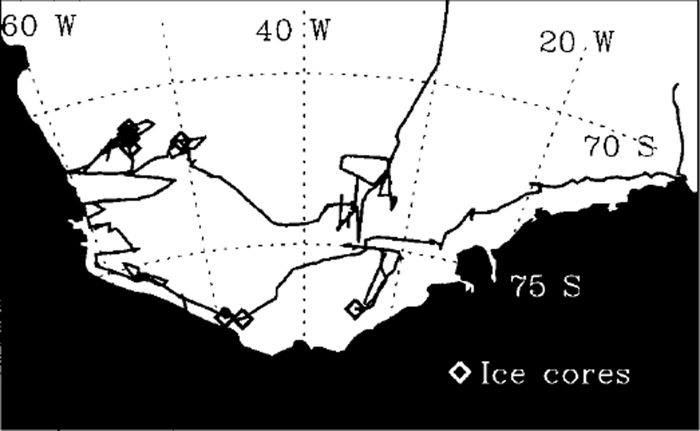
Fig. 2. Ship track in the southern weddell sea of hms Endurance in january-february 1998. the tracks taken between 50° and 60° w (76−72° s) had never been previously transited by vessel and were possible only because of unprecedented open-water conditions (fig. 1) at this time. sea-ice cores were taken at indicated locations.
Satellite observations
Daily passive-microwave, and occasional visual, and radar satellite imagery were analyzed to determine the changes in polynya characteristics with time. The principal data source, passive-microwave imagery, was derived from Special Sensor Microwave/Imager (SSM/I) data using the Bootstrap Algorithm technique as described in Reference ComisoComiso (1995). The principal use of this information is to compute the area of open water, where ice concentrations were found to be less than one-tenth. Comparisons with ship observations over these areas were in good agreement with areas of open water estimated by passive microwave, as well as the position of the ice edge at the northern boundary of the polynya. The change of the polynya area with time was therefore analyzed from these daily microwave images taken from SSM/I, for before, during and after the cruise period, and are presented later.
Atmospheric fields
Wind and temperature records, from European Centre for Medium-range Weather Forecasts (ECMWF) analyses and automatic and manned coastal stations were analyzed to provide comparison records to the sea-ice/open-water observations and for numerical modeling experiments.
Results
Satellite imagery analysis
Figure 3 shows the passive-microwave image map (from 27 February 1998) with ice concentrations computed and shown as the contoured grey tones. The cross-hatched area indicates the area over which the area of open water was computed from the beginning of polynya formation (early November 1997) to its closedown (apparently by freeze-up) in March 1998. From the passive-microwave image analysis, the maximum open-water area was 3 × 10⁵ km2 and extended 500 km north of the Ronne Ice Shelf (at 76° S) to almost 70° S on about 1 March 1998. The open-water area shown as a time series in Figure 4 showed a nearly constant increase with time over approximately 3 months. In contrast, the close-up period took only about 2 weeks, i.e. was at a much higher rate than the opening. The polynya opened systematically from south to north, also suggestive of northward advection of the ice edge. We converted the opening rate, south to north, to an equivalent drift rate. By dividing the areal rate of opening in Figure 5 by the average length of the northern ice edge, an apparent drift of the northern ice edge of 6 km d−1 was obtained. In both behavior and magnitude, however, the close-up appeared to be quite different and suggested a general freeze-up over the entire area, rather than ice advection into the open water. Figure 5, for example, shows the ice image for 12 March 1998, close to the end of the freeze-up period. As shown here, the polynya had "shrunk" in from all sides, closing down to a central hole that finally closed off a few days later.

Fig. 3. Passive-microwave image, shaded and contoured for ice concentration as shown on the bar, using the bootstrap algorithm. the cross-hatched area (40−60° w) shows the region over which polynya area was computed from 15 november 1997 to 15 march 1998.

Fig. 4. The area of open water ( × 10−5 km2) in the crosshatched area of figure 3, computed from the time of first polynya opening (15 november 1997) to the time of closing (15 march 1998).

Fig. 5. Passive-microwave image for 12 march 1998, showing the closing of the polynya area. the white circular area shows the remaining open water after only about 2 weeks of the freeze-up period.
Ship observations
The sea-ice conditions observed during the latter part of summer from the ship and by helicopter north of the polynya region showed predominantly medium (0.7−1.2 m) to thick (>1.2 m) first-year floes with snow depths of 0.1−0.3 m. Most of the ice therefore had formed much earlier in the season, prior to October 1997, and what new ice formed, usually at night, was subjected to intense solar radiation during local solar maximum and usually melted then.
Atmospheric and oceanic forcing
Mean monthly wind fields generated from the ECMWF climatology analyses for November and from ECMWF analyses for the year of the polynya (November 1997) are shown in Figure 6a and b. As shown in Figure 6a, the expected sea-ice drift for this month is generally towards the west, which compacts ice against the Antarctic Peninsula and also brings ice in from the eastern Weddell Sea. A markedly different behavior is suggested for November 1997, where southerly flow persisted and resulted in net ice drift that carried ice away from the coast. As well, less wind flow is indicated from the northeast side, resulting in reduced ice advection from the eastern side of the Weddell Sea. This pattern was similar in December 1997 and January 1998. Comparisons with conditions in summer 1998/99, when the polynya did not appear and the southern Weddell Sea was filled with ice in summer, showed the wind pattern had reverted to that seen in the mean climatology (Fig. 6a).

Fig. 6. (a) Mean monthly winds (10 m height) for november from the ecmwf climatology, (b) ecmwf mean 10 m winds for november 1997.
The physical oceanography (personal communication from K. Nicholls, A. Jenkins and L. Padman, 1998) showed some upwelling of warm deep water but somewhat confined to the northern portions of the continental shelf about 400 km north of the Ronne Ice Shelf There was no apparent penetration of warm deep water into the most southern portions of the Weddell Sea, near the Ronne Ice Shelf, where the polynya first appeared in November and December and was dominantly located throughout the summer.
Discussion
Analyses of the wind fields and comparison to seasonal climatology showed anomalous spring-summer wind fields in the polynya year, with a strong southerly to southwesterly component compared to mean easterly winds typical of summer conditions (Fig. 6a and b). The estimated drift rate for floes under forcing from the mean winds agrees with that previously seen in the region from drifting buoys during winter (e.g. Reference Ackley and HoltAckley and Holt, 1984; Reference Geiger, Ackley, Hibler and JeffriesGeiger and others, 1998), when southerly winds dominate, and confirmed by satellite floe-tracking analysis of microwave imagery during the polynya period (J. King, unpublished observations). The ice and snow structure (snow-covered medium and thick first-year ice) north of the polynya suggests the ice had formed in the previous mid- to late winter (October 1997 or earlier) and had been advected there from the eastern Weddell Sea or from the front of the Ronne Ice Shelf.
The inferred drift and the sea ice observed at the northern polynya edge are therefore consistent with an opening driven by enhanced ice advection. Enhanced sea-ice drift to the north throughout the Weddell Sea, is also shown by the extreme northern extent of ice late in the summer season in Figure lb, compared to the more typical situation (e.g. Fig. 1a). For example, sea ice only left the vicinity of Signy Island (61 ° S, 45° W) in February 1998, hampering the usual earlier-season resupply efforts. The ocean temperature and salinity structure on the continental shelf showed some evidence for upwelling of warm deep water which potentially would have contributed ocean heat flux to melt ice. However, two factors suggest the contribution of upwelling to the Ronne polynya formation in the southern Weddell Sea is relatively small. These are the location of the upwelling, which was well north of the early observed location of the Ronne polynya, and the existence of upwelling in other years when polynya formation has not been observed (Reference Foster and CarmackFoster and Carmack, 1976). Our initial conclusion from observational evidence is that the Ronne polynya is much less dependent on upwelling of deep-ocean heat for its existence in this year than the more frequently observed Ross Sea polynya (Reference Jacobs and ComisoJacobs and Comiso, 1989). (The sensitivity of this behavior is being examined in a numerical modeling study of this region (Hunke and Ackley, in press).
In this case, the atypical southerly winds may be associated with an El Niño-Southern Oscillation (ENSO)-induced atmospheric circulation pattern. In a previous study, Reference Marshall and KingMarshall and King (1998) identified ENSO anomalies in atmospheric circulation that, in their study, accounted for cold and warm western Antarctic Peninsula winters. These anomalies, however, are accompanied by one of the opposite sign in the Weddell Sea sector and are structurally similar to the cold-phase anomalies observed during summer 1997/98.
Additionally, a trigger mechanism to initiate the polynya may have been necessary. We observed that the area directly in front of the Ronne Ice Shelf can form sea ice even in the summer months, because of the sub-freezing air temperatures that persist year-round on the continental ice. A northward drift of ice could therefore be replaced by new ice formed in the south. From observations, either the persistent mean southerly winds or a particularly strong storm event may have created a large enough area of open water away from the cold air near the Ronne Ice Shelf (e.g. >50 km) to then be sustained into and through December by open-water-albedo feedback, i.e. absorption of solar radiation by dark water, which would raise its temperature above freezing and prevent ice from forming. New sea ice generated near the southern coast could also then melt in the warmed ocean water rather than filling in the polynya area with new ice and closing it. A model heat-budget analysis, accounting for radiation, sensible- and latent-heat fluxes, was conducted for a point 100 km north of the ice shelf. In this analysis, the increased shortwave radiation was found to be sufficient to raise open-water temperatures above freezing, sufficient to melt ice, by early December (Hunke and Ackley, in press).
Conclusions
The southerly wind conditions, in both magnitude and direction, are therefore compatible with the observed Ronne polynya formation in late 1997/98, while the predominant summer easterlies account for an ice-filled southern Weddell Sea that is otherwise observed in every year since 1973 (the beginning of all-weather microwave satellite monitoring). Upwelling conditions were observed but are not considered a principal driver of the polynya formation since upwelling is not co-located with the polynya in the early season. Upwelling is also observed in non-polynya years. We conclude that open-water-albedo feedback is, however, necessary to allow the observed polynya formation, since similar drift conditions prevail in winter, arising from southerly winds also, and usually result in extensive new ice formation in front of the Ronne Ice Shelf. The new ice would usually fill a polynya formed by ice advection when the winds slow. The persistent (and strong) southerly winds therefore have quite opposing seasonal effects, leading to high ice production in winter as usually found, and extensive open water if they occur in spring and summer, as seen in this atypical event in 1997/98.


