


Introduction
Reference MercerMercer (1978) predicted that global greenhouse warming would lead to disintegration of ice shelves on the Antarctic Peninsula. Whether related to global or local processes, climatic warming on the Antarctic Peninsula has recently become evident (Reference Raper, Wigley, Mayes, Jones and SalingerRaper and others, 1984; Reference MorrisonMorrison, 1990; Reference RidleyRidley, 1993; Reference KingKing, 1994; Reference ThompsonThompson and others, 1994; Vaughan and Doake, 1996) and local icc-shcet disintegration has been documented (Reference Doake and VaughanDoake and Vaughan, 1991; Reference SkvarcaSkvarca, 1993, Reference Skvarca1994; Reference WardWard 1995; Reference Rott, Skvarca and NaglerRott and others, 1996). For instance, the Wordie Ice Shelf on the west side of the Antarctic Peninsula has completely disappeared (Reference DoakeDoake and Vaughan, 1991). Until now this shelf has marked the southern limit of ice-shelf disintegration. Farther south, retreat of the northern margin of the George VI Ice Shelf was observed by Mercer (1978), Reference Lennon, Loynes, Paren and PotterLennon and others (1982) and Potter and others (1988). By contrast, the Wilkins Ire Shelf has been considered stable, though near its limit óf Viability (Vaughan and others, 1993). Here we report that the retreat of the northern margin of the George VI Ice Shelf is continuing and that recession of the northern margin of the Wilkins Ice Shelf has begun (Fig. 1). We determined past frontal positions of these shelves from the literature and measured recent changes on older Landsat and more recent European remote-sensing satellite synthetic aperture radar (ERS SAR) images.

Fig. 1. Antarctic Peninsula. Location map of ire shelves, Landsat and ERS-1 images. B, Bellingshausen Sea; D, Dyer Plateau; F, Faraday Station; A4, Marguerite Bay; R, Rothera Station; W, Wordie Ice Shelf.
Method
We used two band 7 (near-infrared) 1974 Landsat multi-spectral scanner (MSS; 80 m/pixel resolution) images in the form of computer-compatible tapes, archived at the
Table 1. Satellite images used in study
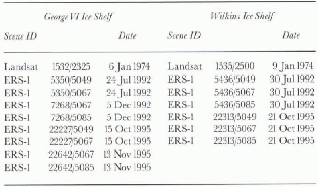
U.S. Geological Survey, Flagstaff, AZ (Fig. 1;Table 1). Additionally, we used 1992 and 1995 ERS-1 image mosaics (25 m resolution at 12.5 m/pixel), in the form of CD-ROMs in Universal Transverse Mercator map projection using the World Geodetic System 1984 ellipsoid, and furnished by the European Space Agency through the German DLR (Deutsche Forschungsanslalt für Luft und Raumfahrt) (Fig. 1; Table 1). The DLR also provided all images geometrically adjusted to reference levels of sea level (0 m elevation). This procedure ensured that the coastline, where at sea level, has no range displacement or layover errors. Thus, the coastlines are correct on map projections and match on the mosaics. However, with in the SAR images, all elevations above this level are subject to terrain distortion. Because the early Landsat images have unstable internal geometry, we registered the Landsat images to the ERS images. To co-register ERS images, we used the furnished latitude and longitude coordinates based on orbital parameters. Previous investigations (Lucchitta and others, 1995) showed that images coregistered by furnished coordinates may have relative maximum ground location errors of 50 m (Roth and others, 1993). Compressing the images to 25 m/pixel by averaging squares of four pixels reduced speckle on the radar images. Noisy data were also removed by applying adaptive box filters described in Reference Eliason and McEwenEliason and McEwen (1990). We enhanced the Landsat images to bring out details in the ice-shelf fronts by applying contrast-enhancing stretches.
After the above processing, we recorded the location of ice-shelf fronts and crevasses. For multi-temporal composites, we overlayed the mosaics taken at three different times represented by the early Landsat and two later ERS images. The colors on the composites are due to spectral reflectivity of the Landsat band and backscalter intensity on the ERS images. On Landsat images, the differences between shelf ice and sea ice are small, making it difficult to distinguish between them. On ERS images these ice types are readily distinguished. After converting the multi-temporal composites to Lambert azimuthal equal-area projections, we digitized the locations of the ice-shelf margins at different times and calculated the areas of ice lost during retreat.
George VI Ice Shelf
The GeorgeVI Ice Shelf measures about 25000 km2 (Potter and others, 1988). It receives most of its ice from the Antarctic Peninsula, whose ice streams extend into the shelf and almost reach its western margin. Ice from Alexander Island extends only a few kilometers into the shelf (Reference Bishop and WaltonBishop and Walton, 1981; Potter and others, 1984). The ice shelf varies in thickness from about 100 m near its northern ice front to a maximum of about 500 m (Bishop and Walton, 1981; Lennon and others, 1982; Reference TalbotTalbot, 1988). Warm-water intrusion from the Circumpolar Deep Water current from the southeast Pacific basin emerges onto the continental shelf and extends underneath the northern GeorgeVI Ice Shelf (Lennon and others, 1982; Potter and others, 1984; Potter and Paren, 1985; Talbot, 1988). The warm water contributes significantly to basal melting of the shelf (Potter and others. 1988), with a resulting average equilibrium basal melt rate of about 2 ma−1 (Lennon and others, 1982; Potter and others, 1984; Potter and Paren, 1985). The basal melt rate at the ice front was estimated to be as high as 10 m a−1 (Lennon and others, 1982).
The British Graham Land Expedition visited Cape Jeremy in 1936 and reported that shelf ice filled GeorgeVI Sound (Fig. 2) and was broken by rifts which were floored by sea ice (Reference Fleming, Stephenson, Roberts and BertramFleming and others, 1938). This statement has been interpreted to indicate that the sound was filled with shelf ice to Cape Jeremy (Doake, 1982). A 1979 sketch map (U.S. Geological Survey, 1979) shows the ice-shelf front extending from Niznik Island southwestward across the sound. The shelf south of the front is occupied by broken shelf segments. This portrayal was based on the early but unenhanced Landsat images, which showed the position of the ice front poorly. Doake (1982) commented that it was difficult to locate the true ice-shelf front because of the fragmented shelf. The frontal position as shown on this sketch map is reproduced in most subsequent articles discussing the George VI Ice Shelf (Bishop and Walton, 1981; Lennon and others, 1982). Our contrast-stretched Landsat image of 1974 depicts the ice-shelf front clearly and shows that the previously published front positions were incorrect; the front extended from just north of Niznik Island westward straight across the sound to Alexander Island (Fig. 2). By 1974, the area north of this front had cleared of the rifted icebergs and shelf segments reported by the 1936 Fleming expedition. If the shelf in 1936 indeed extended all the way to Capejeremy, this clearing of rifted ice would mean a 40 km retreat of the shelf between 1936 and 1974.

Fig. 2. Excerpt of Landsat image, 6 January 1974, showing George VI Sound and covering northern margin of George VI Ice Shelf. Arrows denote location of ice-shelffront. A, Alexander Island; CJ, Cape Jeremy; N, Niznik Island; P, polynya.
By 1974, as shown on maps and observed by Doake (1982), the region behind the front was again occupied by complexly divided large shelf segments separated by rifts, including the fractured tongue of an unnamed glacier. Lennon and others (1982) report on ice-front retreats observed in 1977, 1979 and 1981. Potter and others (1988 show the loc ation of the 1983 front as a few km north of tha shown on our ERS images. By July 1992, as seen on ihi earlier ERS image, the front had retreated 20-30 km fron the 1974 position, and all the rifted ice-shelf segments ant the fractured ice-stream tongue had broken out; the regioi was completely cleared of the 1974shelfice (Fig. 3). The fron had retreated beyond the southern margin of a conspicuou polynya at the west side of the sound that was already opci in 1974 (Fig. 2) and that has been mentioned in several re ports as the only ice-free area near the northern ice front (Lennon and others, 1982; Potter and Paren, 1985; Poller and others, 1988). This polynya is now gone due to shelf retreat, and our ERS radar images show no trace of it in the sea ice. Our investigation shows that a total of 906 km of ice was lost between 1974 and 1992, amounting to an average of about 50 km2 a~1 (Fig. 4; Table 2).

Fig. 3. Excerpt of 15 October and 13 November 1995 ERS-1 image mosaic covering northern margin of George VI Ice Shelf. Ice-shelf margin has retreated to south of thepolynya shown in Figure 2.

Fig. 4. Areas of retreat. Vertical hachures (906km2) show retreat from Landsat 1974 ice-shelf front (upper boundary) to ERS-1 1992 front (middle boundary). Horizontal hachures (87 km2) show retreat from ERS-1 1992 front to 1995front (lower boundary). Diagram is superimposed on ERS-1 image mosaic of 15 October and 13 November 1995.
Table 2. Areas and average ice loss for George Viand VI and Wilkins Ice Shelves
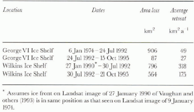
By October 1995 (ERS image), an additional 6 km had calved on the cast side of the shelf. The area lost is 87 km2, or an average of about 30 km2 a−1 (Fig. 4; Table 2). Overall, the shelf behind the 1995 front is less rifted than that behind earlier frontal positions, except for a region along the east side of the shelf, where large crevasses already existed in 1974.
Potter and Paren (1985) estimate that the ice-shelf front between 1974 and 1979 lost about 25 km3 by calving, or an average of 5 km3a , whereas annual equilibrium loss would be only about 0.3 km . Assuming a frontal ice thickness of about 100 m, the area lost between 1974 and 1979 would average 50 km2 a−1. Our retreat rates of about 50 km2 a−1 (1974-92) and about 30 km2 a−1 (1992-95) agree reasonably well with their estimate. Our data confirm thai the average retreat rate significantly outpaces the hypothetical advance rate of a stable front and show that rapid retreat continued through 1995.
Vaughan and Doake (1996) define an ice shelf that is no longer viable as one that will suffer progressive retreat, via a series of small calving events occurring each year over a period of many years, without substantial readvance. Normal calving, by contrast, follows significant readvance of the ice shelf. Our observations show that the George VI Ice Shelf has undergone a persistent retreat over at least the last 20 years and perhaps since 1936, without any significant observable readvance. Thus, it fits Vaughan and Doake's definition, and we may indeed be witnessing the first stages of disintegration.
Wilkins Ice Shelf
The Wilkins Ice Shelf has an area of about 16000 km2 (Vaughan and others, 1993). It is fed mostly by in situ accumulation, like the Larsen Ice Shelf on the northeast side of the peninsula (Vaughan and others, 1993), but unlike the George VI and Wordie Ice Shelves (Doake and Vaughan, 1991), which are fed by glaciers. The middle of the shelf is very low, but Vaughan and others (1993) mapped a topographic bulge along the shelf's western margin, where most of the accumulation appears to occur.
The Wilkins Ice Shelf has been studied relatively little. Radio-echo sounding of the late 1960s and early 1970s (Reference SmithSmith, 1972; Crablree, 1983) was largely unsuccessful. Velocity measurements (about 60 m a−1) were made near the center of the shelf in 1972-73 (Vaughan and others, 1993), and a hole was drilled in that area (Swithinhank, 1988). The most comprehensive report is by Vaughan and others (1993), who looked at the shelf using a variety of remote-sensing techniques and reviewed previously acquired data with in the context of their investigation. They discussed the morphology of the shelf based on Landsat images and Geosat altimeter data. They also investigated the ice-front positions on Landsat images of 1973,1986 and 1990 and found them stable for the two preceding decades; the ice front on all Landsat images up to that time showed no significant advance or retreat. However, our ERS images show that by 1992 a significant change had occurred.

Fig. 5. Fig. 5. Landsat image, 9 January 1974, covering northern margin of Wilkins Ice Shelf. Arrows denote location of ice-shelffront. Note extensive sea-ice cover, even though image was acquired in summer. A, Alexander Island; Q Charcot Island; R, Rothschild Island; L, lake/hole in ice shelf of Vaughan and others (1993).
Our Landsat image of January 1974 shows that the northern margin of the Wilkins Ice Shelf extended from Rothschild Island near the Alexander Peninsula to Charcot Island farther west (Fig. 5). The ice-shelf front had a conspicuous promontory projecting north near Charcot Island, and a bay extending south near Rothschild Island. By 1992 the front had retreated by about 10 km, the promontory had disappeared and the bay was enlarged (Fig. 6). Armadas of sharp-edged tabular icebergs were visible in front of the shelf, suggesting recent break-up. Several of the icebergs are larger than 1 km by 10 km, similar in size to tabular icebergs that were observed in the early stages of break-up of the western part of the Wordie Ice Shelf (Doake and Vaughan, 1991). The icebergs are close to the shelf front, not far removed from their prc-calving position. By 1995 (ERS image), the front retreated another 8-10 km, further enlarging the bay near Rothschild Island and shedding a new set of icebergs (Fig. 7). Most of these newer icebergs are not as sharply delineated by straight edges as those from the earlier iceberg discharge; they show more irregular boundaries and a greater range in size. Large rifts developed behind the new front, lining up with rifts that already existed in the 1974 Landsat image. Our investigation showed that between 1990 and 1992 the shelf lost 796 km , at an average rate of about 320 km2 a−1, assuming that the position of 1990 (Vaughan and others, 1993) matches that of 1974 (Fig. 8; Table 2). Between 1992 and 1995 the shelf lost 564 km2 of ice, at an average rate of about 180 km2 a−1.

Fig. 6. Excerpt of ERS-1 image mosaic, 30 July 1992, covering Wilkins Ice Shelf. Note tabular icebergs calving off northern margin at lop of image. L, lake/hole in ice shelf.

Fig. 7. Excerpt of ERS-1 image mosaic, 21 October 1995. covering Wilkins Ice Shelf. Note tabular icebergs north of new set of more irregular icebergs. Next to ice-shelf margin is sea ice with narrow iceberg slivers. Also note new rifts. L, lake/hole in ice shelf.
Near the northern shelf center a lake, or a hole in the shelf, persisted for the last two decades (Fig. 5). The lake/ hole coincides with a local depression almost at sea level (Vaughan and others, 1993). The lake/hole appears to have a similar size on our 1992 ERS image to that on previous Landsat images, but is surrounded by ice with lower back-scatter characteristics, perhaps seasonally wet ice. Similar-looking dark splotches are seen farther east on both ERS images. Ice-surface melt pools noted by Vaughan and others (1993) near Rothschild Island also persist on our images. The Wilkins Ice Shelf had the longest melt season among four shelves on the peninsula investigated by Ridley (1993, Fig. 4). Reference SwithinbankSwithinbank (1988) comments that the ice shelf may be unusually thin and that the failure to acquire radio-echo sounding returns could indicate that parts of the ice shelf are brine-soaked to sea level. A hole drilled with a hand auger in January 1972 penetrated soaked snow and found a water table at a depth of 5.5 m. All of these observations suggest that the shelf may be subject to rapid break-up.

Fig. 8. Areas of retreat. Vertical hachures (796km2) show retreat from Landsat 1974 ire-shelffront (upper boundary) to ERS-1 1992 front (middle boundary). Horizontal hachures (564 km2) show retreat from ERS-1 1992 to 1995 front (lower boundary). Diagram is superimposed on ERS-1 image of 21 October 1995.
Vaughan and others (1993) speculate that the Wilkins ice front is likely to decay by normal calving processes and is unlikely to undergo the sudden disintegration seen on the Wordie Ice Shelf, at least until the calving front decouples from the fringing islands. However, they caution thai changes in accumulation and basal melting rates may dominate any dynamic effect. The basal melt rate of the shelf is assumed to be 1-2 m a−1 , similar to that of the GeorgeVI Ice Shelf, because it receives the same warm-water inllux of the Circumpolar Deep Water current (Potter and others, 1988). Talbot (1988) suggests that this warm water may contribute to the recent disintegration of ice shelves. Also striking is a major decrease in sea-ice extent in the Bellingshausen Sea from late 1988 through early 1991 (Reference Jacobs and ComisoJacobs and Comiso, 1993), coincident with the warmest years on record at the Antarctic Peninsula (Morrison, 1990). These authors observed a record retreat of sea ice in March 1989, and their Figure 2 shows that in February of 1989-91 most of the sea ice off the northern margin of the Wilkins Ice Shelf was missing. Whether and flow this sea-ice loss has affected the ice-shelf margin remains to be explored.
Warming Trend
The disintegration of Antarctic ice shelves has been attributed to a recent atmospheric warming trend (Vaughan and Doake, 1996). Morrison (1990) showed that 1989 was the warmest year on record at Rothera Station near Marguerite Bay. She states that the warming is caused by a lack of cold periods, particularly in the winter months. Ridley (1993) counted the number of days showing melt features over ice shelves on the peninsula and elsewhere using passive microwave sensors. He concluded that between 1978 and 1991 the number of melt days on ice shelves of the Antarctic Peninsula has increased by about 1 day per year. Satellite passive microwave data show a record decrease in sea-ice extent in the Bellingshausen Sea from mid-1988 through early 1991 (Jacobs and Comiso, 1993). Thompson and others (1994), from oxygen-isotope analysis of ice-core records on the Dyer Plateau, established a prominent warming trend since 1950, with the last two decades being the warmest in 500 years. At Faraday Station, a warming trend of about 2.5°C has been measured since 1945 (King, 1994).
The west side of the Antarctic Peninsula is about 6-7 C warmer than the east side (Reference Martin and PeelMartin and Peel, 1978; Reference ReynoldsReynolds, 1981), suggesting that ice shelves on the west side are more likely to disintegrate. Mercer (1978) placed the limit of ice-shelf viability near the January 0°C air-temperature isotherm, whereas Vaughan and Doake (1996) placed the limit at the 5°C mean annual air-temperature isotherm, after observing that this isotherm coincided reasonably well with non-viable shelves. Reynolds (1981) plotted a contour map of mean annual air temperatures over the Antarctic Peninsula between 1965 and 1980, based on temperatures in ice cores taken 10 m below the surface. Assuming a warming trend of about 2.5GC as reported by King (1994), Reynolds' -7.5°C isotherm would be near the present-clay -5°C isotherm (Vaughan and Doake, 1996), and therefore his -7.5°G isotherm designates the location of the possible present limit of ice-shelf viability.
The northern margin of the George VI Ice Shelf (alls exactly on Reynolds' -7.5°C isotherm and thus may be at its limit of viability. The northern margin of the Wilkins Ice Shelf lies at Reynolds' (1981) -8°C isotherm, south of, but close to, the 7.5°C isotherm. The coincidence of these isotherms with our observed ice-shelf retreats strongly suggest s that the retreats are linked to this atmospheric warming trend. Our observations thus bear out Mercer's (1978) prediction of potential ice-shelf loss on the Antarctic Peninsula.
Conclusion
The effects of the warming trend in the Antarctic Peninsula appear to be spreading south. We are now witnessing significant retreat of the northern margins of the George VI Ice Shell, and a dramatic and fast disintegration of the northern margin of the Wilkins Ice Shelf.The.se two shelves mark the southernmost occurrence of ice-shelf retreat documented. Our observations support previous predictions (Mercer, 1978; Vaughan and others, 1993; Vaughan and Doake, 1996) that these shelves are the most likely to break up if the warming trend continues.
Acknowledgements
We are grateful for helpful reviews by B. Raup, J. Kargel and H. Rott. The research was funded by the Global Change and Climate History Program of the U.S. Geological Survey. The European Space Agency provided the ERS images free of charge.


