


1. Introduction
Glaciers in the Nepal Himalaya have been recognized as an indicator of changing climate because their dimensions change in response to surrounding climatic conditions, and therefore monitoring of glaciers has been carried out worldwide (Reference Holmlund, Karlén and GruddHolmlund and others, 1996; Reference Kadota, Fujita, Seko, Kayastha and AgetaKadota and others, 1997; Reference BenistonBeniston 2003; Reference Raup, Racoviteanu, Khalsa, Helm, Armstrong and ArnaudRaup and others, 2007; Reference GardnerGardner and others, 2013). Himalayan glaciers are very vulnerable to the increase in air temperature, especially the summer-accumulation-type glaciers because of the strong negative effect on glacier mass balance (Reference AgetaAgeta and others, 2001). For example, accelerated shrinkage of Himalayan glaciers has been reported in the past (Reference YamadaYamada and others, 1992; Reference Kadota, Seko and AgetaKadota and others, 1993; Reference BolchBolch and others, 2012). However, recent work has shown that glacier responses to climate change are highly heterogeneous in the Himalaya and nearby ranges (Reference Fujita and NuimuraFujita and Nuimura, 2011; Reference Kargel, Cogley, Leonard, Haritashya and ByersKargel and others, 2011; Reference BolchBolch and others, 2012). Evaluation of glacier mass balance is not only important for regional water resources but also for global sea-level change (Reference Fujita, Takeuchi and SekoFujita and others, 1998; Reference Rignot, Velicogna, Van den Broeke, Monaghan and LenaertsRignot and others, 2011; Reference Jacob, Wahr, Pfeffer and SwensonJacob and others, 2012; Reference ShepherdShepherd and others, 2012; Reference GardnerGardner and others, 2013). It is also important to monitor the mass balance of summer-accumulation-type glaciers to better understand the impact of climate change on the volume of these glaciers. With such mass-balance measurements, the downstream water availability can also be predicted for the coming years. However, there is a lack of continuous monitoring of the glacier, also without any instances of long-term mass-balance measurements. This is mainly due to difficult access to the mountains, and financial constraints. In this context, glaciological observations are being carried out on Yala Glacier by the Cryosphere Monitoring Project (CMP). Our analysis of crucially needed observational data buttresses and extends knowledge obtained about Yala Glacier by the energy-/mass-balance modeling approach of Reference Fujita and NuimuraFujita and Nuimura (2011).
Temperature and precipitation vary with space and time, thus defining the local weather and climate of any particular place. Several factors are responsible for the change in these variables. Climatically, altitudinal distribution of precipitation has been analyzed according to climatic region (Reference BarryBarry, 1981). The summer monsoon climate of the Nepal Himalaya, where summer precipitation exceeds winter precipitation, is considerably influenced by the Indian monsoon, and apparent seasonal variation exists in meteorological fields (Reference SekoSeko, 1987; Reference TakahashiTakahashi and others, 1987; Reference Seko and TakahashiSeko and Takahashi, 1991).
There is a lack of availability of sufficient hydrological and meteorological data of the high-altitude regions of the Nepal Himalaya. Regular monitoring and maintenance of the existing weather stations and other temperature and precipitation sensors is necessary for collecting hydrological and meteorological information in such regions. Reference SekoSeko (1987), Reference Seko and TakahashiSeko and Takahashi (1991), Reference Shiraiwa, Ueno and YamadaShiraiwa and others (1992) and Reference Ueno, Shiraiwa and YamadaUeno and others (1993) have evaluated the distribution of precipitation in the valley. However, the change in meteorological parameters related to glacier mass balance and runoff in the valley has not been studied with respect to global climate change in the recent past.
The main objective of this study is to calculate the mass balance of Yala Glacier, but while doing so, another objective is to analyze the temperature and precipitation gradients and diurnal cycles in Langtang Valley. Mass-balance observations were carried out from November 2011 to November 2012, while meteorological observations are performed in the valley from May to October 2012 so as to determine the altitudinal variation of precipitation and temperature during the observation period. These measurements are, however, just the start of a comprehensive scientific study initiated by the CMP. The project aims to yield a multi-year mass-balance observation that can be of great use in determining the eventual state of the cryosphere of the Himalayan region.
2. Study Area
Several sets of glaciological, meteorological and hydrological observations have been performed in Langtang Valley, Nepal, since 1981 (e.g. Reference HiguchiHiguchi, 1984; Reference Watanabe and HiguchiWatanabe and Higuchi, 1987; Reference YamadaYamada, 1989). The fluctuations of glaciers in Langtang Valley were reported by Reference Kappenberger, Steinegger, Braun and KostkaKappenberger and others (1993). Snow-pit observations have been carried out at 5350 m a.s.l. in the accumulation zone of Yala Glacier, Langtang Valley (Reference Iida, Endo, Kohshima, Motoyama and WatanabeIida and others, 1987; Reference OzawaOzawa, 1991). Glaciological observations of Yala Glacier were carried out in 1994 and 1996 (Reference Fujita, Takeuchi and SekoFujita and others, 1998).
The study site for mass balance, Yala Glacier (288140 N, 85036' E), lies in Rasuwa district, central Nepal (Fig. 1). It is a debris-free glacier which lies near Khymjung Glacier, Langtang Valley. The highest and lowest altitudes of the glacier are 5749 and 5128m (Advanced Spaceborne Thermal Emission and Reflection Radiometer digital elevation model (ASTER DEM, 2010, 30m resolution, downloaded from http://gdex.cr.usgs.gov/gdex/)), respectively. Its area is 1.61 km2. It has a widespread shape and gentle slope (228) facing southwest (Reference Fujita, Takeuchi and SekoFujita and others, 1998). A hypsograph of Yala Glacier shows that most of the glacier area lies in the altitude range 5200–5350 ma.s.l.
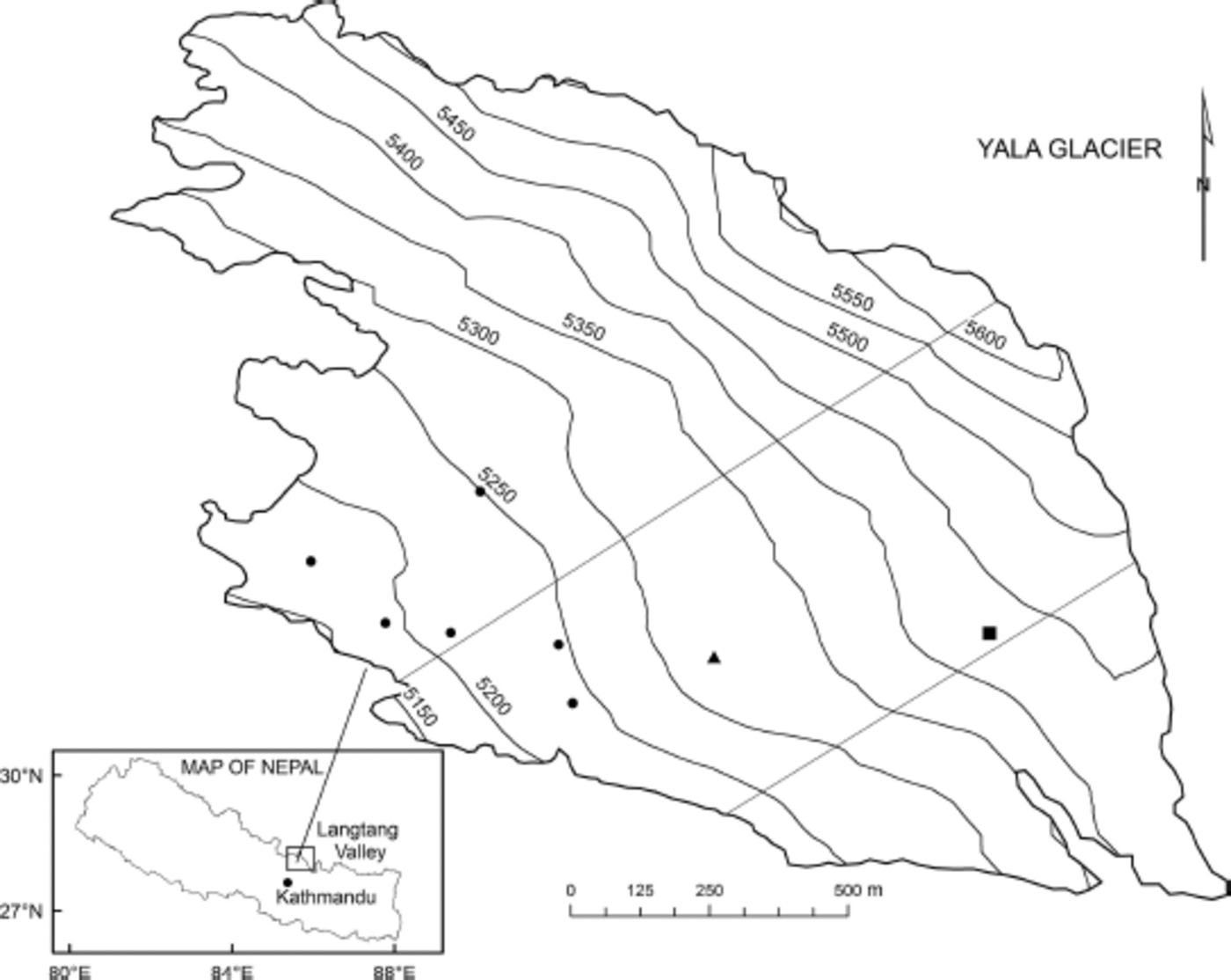
Fig. 1. Map of Nepal showing Langtang Valley and Yala Glacier (RapidEye 2010). Solid circles on Yala Glacier denote the stakes installed by the CMP for mass-balance measurements. Solid triangle and square denote Chinese and Japanese stakes respectively. The areas between the two straight lines (‘transect’) are assumed as the representative areas for the calculation of mass balance as considered by Reference Fujita, Takeuchi and SekoFujita and others (1998).
Analysis of temperature and precipitation gradients is carried out in Langtang Valley, Rasuwa district. It is a glacierized catchment with both debris-free and debriscovered glaciers. It is located to the north of Kathmandu and shares a border with Tibet on the northern side.
3. Data and Methods
3.1. Temperature gradients
Six temperature sensors are established at Chilime Hydropower, Lama Hotel, Langtang, Kyangjing, Jathang and Numthang at elevations of 1396, 2492, 3539, 3857, 3875 and 3981 m a.s.l., respectively. Automatic weather stations (AWS) are set up at Kyangjing Base House (‘BH’, hereafter) and Yala Glacier base camp (‘BC’, hereafter) at 3857 and 5100 ma.s.l., respectively (Fig. 2).
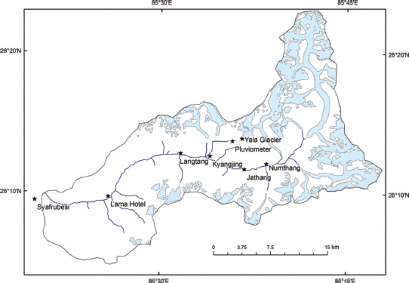
Fig. 2. Map of Langtang Valley. Blue parts denote glaciers based on Reference Bajracharya, Maharjan, Shrestha, Blanco and KheradmandBajracharya and others (2011). Stars denote the meteorological stations installed in this study.
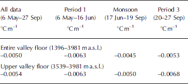
Hourly data recorded by the temperature sensors are used for analysis. The data from all the temperature loggers are available from 6 May to 27 September 2012 (referred to as ‘all data’ from now on). The data are divided into period 1 (6 May–16 June 2012), period 2 or monsoon (17 June–19 September 2012) and period 3 (20–27 September 2012). Regression temperature lapse rate during periods 1–3 is calculated for the entire valley floor (1396–3981m a.s.l.) and the upper valley floor (3539–3981m a.s.l.).
Hourly temperature data from the two AWS at BH and BC are used to calculate the temperature lapse rate between BH and BC which is found to be –0.055°C (100 m)–1. This value is used for the extrapolation of air temperature recorded at BH to estimate air temperature at BC. The same lapse rate is applied to estimate accumulation at each site on the glacier. Reference TakahashiTakahashi and others (1987) calculated the lapse rate between BH and BC to be –0.06°C (100 m–1), which was corrected to –0.057°C (100 m–1) by Reference Fujita, Sakai and ChhetriFujita and others (1997).
3.2. Precipitation gradients
Six tipping buckets are established at Chilime Hydropower, Lama Hotel, Langtang, Kyangjing, Jathang and Numthang at 1396, 2492, 3539, 3857, 3875 and 3981 m a.s.l., respectively. A pluviometer is set up near Yala Glacier at 4831 ma.s.l. (Fig. 2). Precipitation data recorded at six tipping buckets, a pluviometer near Yala and the AWS at BC from May to October 2012 are used to observe the monthly precipitation amount. The regression lapse rate of precipitation is calculated using these data.
To calculate total solid precipitation at BC, precipitation and temperature data recorded at the AWS at BC from 8 May to 3 November 2012 are used. A relation between air temperature and percentage of snowfall as derived in Reference Kayastha, Ageta, Fujita, Jong, Collins and RanziKayastha and others (2005) is used to separate snow and rain from precipitation amount. According to the relation, all precipitation is considered as snow when the temperature is 0°C or <0°C; as rain when the temperature is equal to or higher than 3.6°C; and as a mixture of snow and rain at 0–3.6°C.
To estimate the amount of solid precipitation at BC from 10 November 2011 until 7 May 2012, precipitation data collected at BH are used and values are extrapolated to BC using the relation P BC=1.43 x P BH, where P BH is the precipitation recorded at BH and PBC is the precipitation estimated at BC. This relationship is established based on observation of precipitation data collected at BH and BC from 15 June to 15 September 2012. No altitudinal gradient of precipitation amount was assumed on the glacier since the altitude range of the glacier is small.
3.3. Diurnal cycle of temperature and precipitation
Temperature and precipitation data recorded at Syafrubesi, Lama Hotel, Langtang, Kyangjing, Jathang and Numthang from 6 May to 27 September 2012 are used to observe the diurnal cycle of temperature and precipitation at these stations.
3.4. Mass balance
Mass-balance measurements at six stakes on Yala Glacier, at varying elevations below 5250ma.s.l., have been carried out by the CMP since November 2011. Other stakes, installed by Chinese and Japanese scientists (‘Chinese and Japanese stakes’, hereafter), above this elevation are also measured and used in this study. Meteorological variables recorded by the AWS set up at BC are used to estimate the amount of precipitation at BC. CMP stakes, Chinese and Japanese stakes were measured again on 3 November 2012. A representative area of the glacier, a transect of the glacier, studied by Reference Fujita, Takeuchi and SekoFujita and others (1998), is considered for the mass-balance calculation (Fig. 1).
In this study, specific mass balance (mw.e.) is calculated using density profiles obtained at each site by snow-pit analysis on 10 and 11 November 2011 and 3 November 2012. The density of ice used was assumed to be 870 kg m–3 (Reference Fujita, Takeuchi and SekoFujita and others, 1998).
For each stake on the glacier, the amount of ablation is calculated by subtracting the estimated accumulation from the observed mass balance. Extrapolation of the specific mass balance observed at stakes at 5244, 5317 and 5444 m a.s.l. is used to estimate the equilibrium-line altitude (ELA) and the specific mass balance in the accumulation region of a representative area of the glacier where no stakes are installed. The areal average of mass balance is then calculated.
4. Results and Discussion
4.1. Temperature gradients
Table 1 shows the value of mean lapse rate for the whole valley and for the upper valley. Lapse rate values are always lower during the monsoon than in other periods. Lapse rates for the upper valley are steeper but the correlation values are lower than for the whole valley. Lapse rates are steeper during periods 1 and 3 and lowest during the monsoon period. This implies that solar radiation acts as an important factor for steep lapse rates during periods 1 and 3 as there is less radiation during the monsoon due to the presence of monsoon clouds. The calculated lapse rates are very similar to that calculated by Reference TakahashiTakahashi and others (1987), which was 0.006°Cm–1 from July 1985 to July 1986 in the same valley between 3920 and 5090 m a.s.l.
Table 1. Mean lapse rate calculated for the entire valley floor and upper valley floor
4.2. Precipitation gradients
Cumulative precipitation recorded by six tipping buckets shows that the monsoon began on 17 June (7 days delayed compared to the normal day of onset, 10 June) and receded on 20 September (which is the normal retreat day) 2012. The amount of precipitation increased in the lower valley from 1396ma.s.l. to 2492 ma.s.l. The tipping bucket at Lama Hotel received the maximum amount of rainfall in the valley. Higher up, the amount of precipitation decreases in the valley up to 3875 ma.s.l. Above this elevation, the amount of monthly precipitation starts to increase again (Fig. 3).
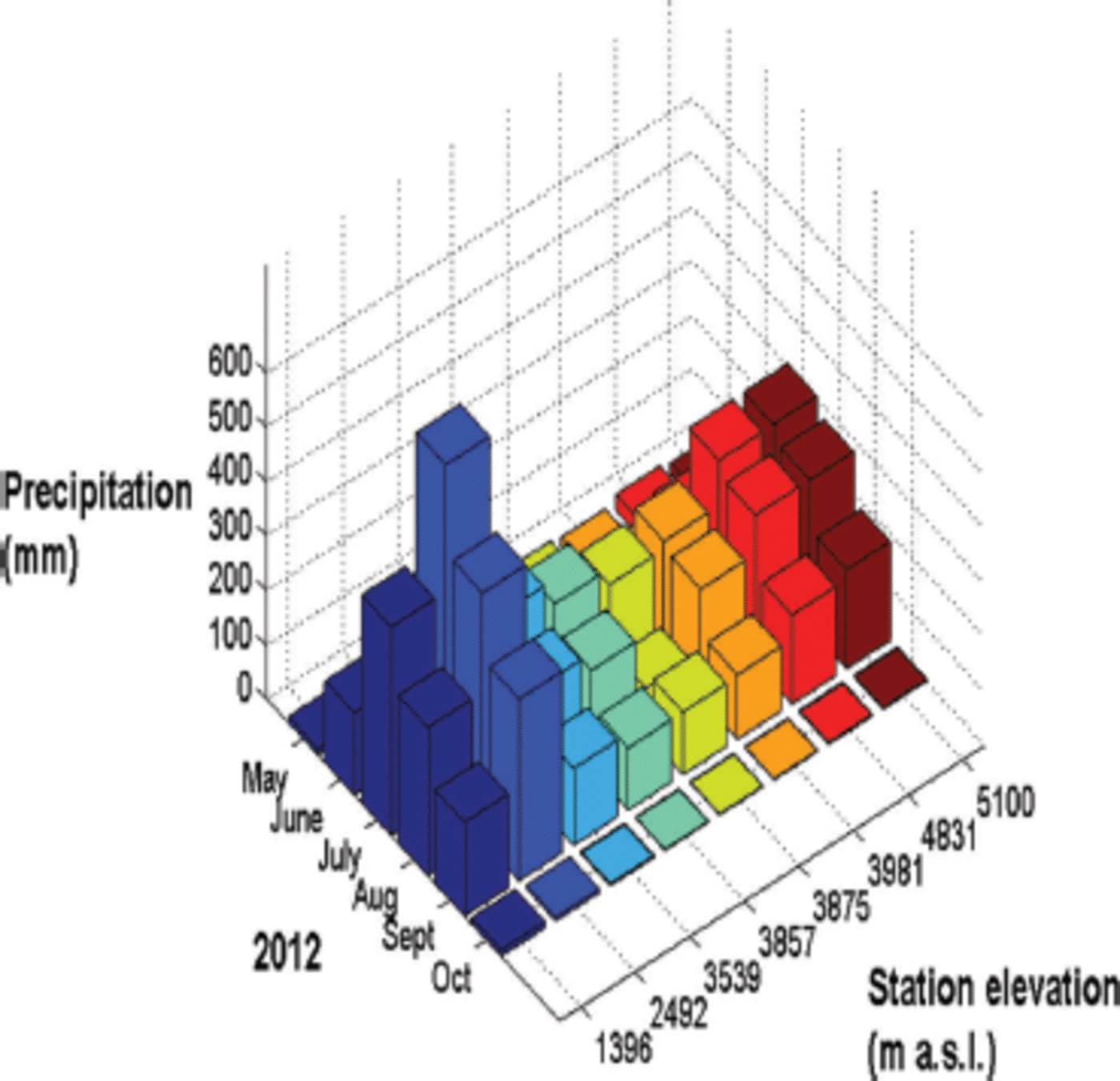
Fig. 3. Monthly precipitation recorded at different elevations in Langtang Valley from May to October 2012.
The regression lapse rate of monthly precipitation calculated from June to September 2012 shows that the monthly precipitation amount in the valley increases at a rate of 15 mm (100 m)–1 from 1396 to 2492 ma.s.l. It decreases at a rate of 24 mm(100 m)–1 from 3539 to 3875 ma.s.l. It starts to increase again at 6 mm (100 m)–1 from 3981 to 5100 m a.s.l. This increase in the amount of precipitation with altitude above 3981 m a.s.l. is consistent with the results obtained from meteorological observations in Langtang Valley carried out in the past (Reference SekoSeko, 1987; Reference Fujita, Sakai and ChhetriFujita and others, 1997). This could be due to convective precipitation associated with mesoscale thermal circulation in the valley, as suggested by Reference SekoSeko (1987).
4.3. Diurnal cycle of temperature and precipitation
There is a significant difference between day and night temperatures at all six stations. Precipitation events are common during the night and much less so during the day at all stations. Most precipitation events occur after 15:00 and before 08:00. Nocturnal precipitation is due to nocturnal convection in the mountain valleys in Nepal caused by continuous migration of humid air mass due to up-valley winds and downslope wind by radiative cooling (Reference Ohata, Higuchi and IkegamiOhata and others, 1981). Diurnal cycles of temperature are identical for stations in the upper valley. Daytime temperature rises above 20°C and 15°C at Syafrubesi and Lama Hotel, respectively, but remains below 15°C in the upper valley. Reference Ueno and YamadaUeno and others (1990) also studied the characteristics of diurnal variation of the precipitation in the valley from mid-August to the beginning of October in 1987. They also found similar results and classified three types of dominant precipitation pattern: maximum precipitation usually occurred from early evening until midnight; the other two types occurred from morning (07:00–08:00) to afternoon (14:00–16:00) and from late night (00:00–02:00) to early morning (05:00–06:00).
4.4. Mass balance
The calculated mass balance of Yala Glacier from 10 November 2011 to 3 November 2012 is –0.89mw.e. The estimated ELA is 5455 m a.s.l. The mass balance is more than twice as negative as that observed by Fujita and others (1998) during the 1996 monsoon season, which was –0.36mw.e. This confirms that Yala Glacier is in strong negative mass balance recently compared with the 1990s. This is mainly due to increased air temperatures since 1990 and may also be due to increased longwave radiation from the more exposed rock part in the lower area of the glacier. Some stakes show increase in ablation with increasing altitude (Fig. 4), mainly due to their southwest aspect which receives more solar radiation than other stakes.
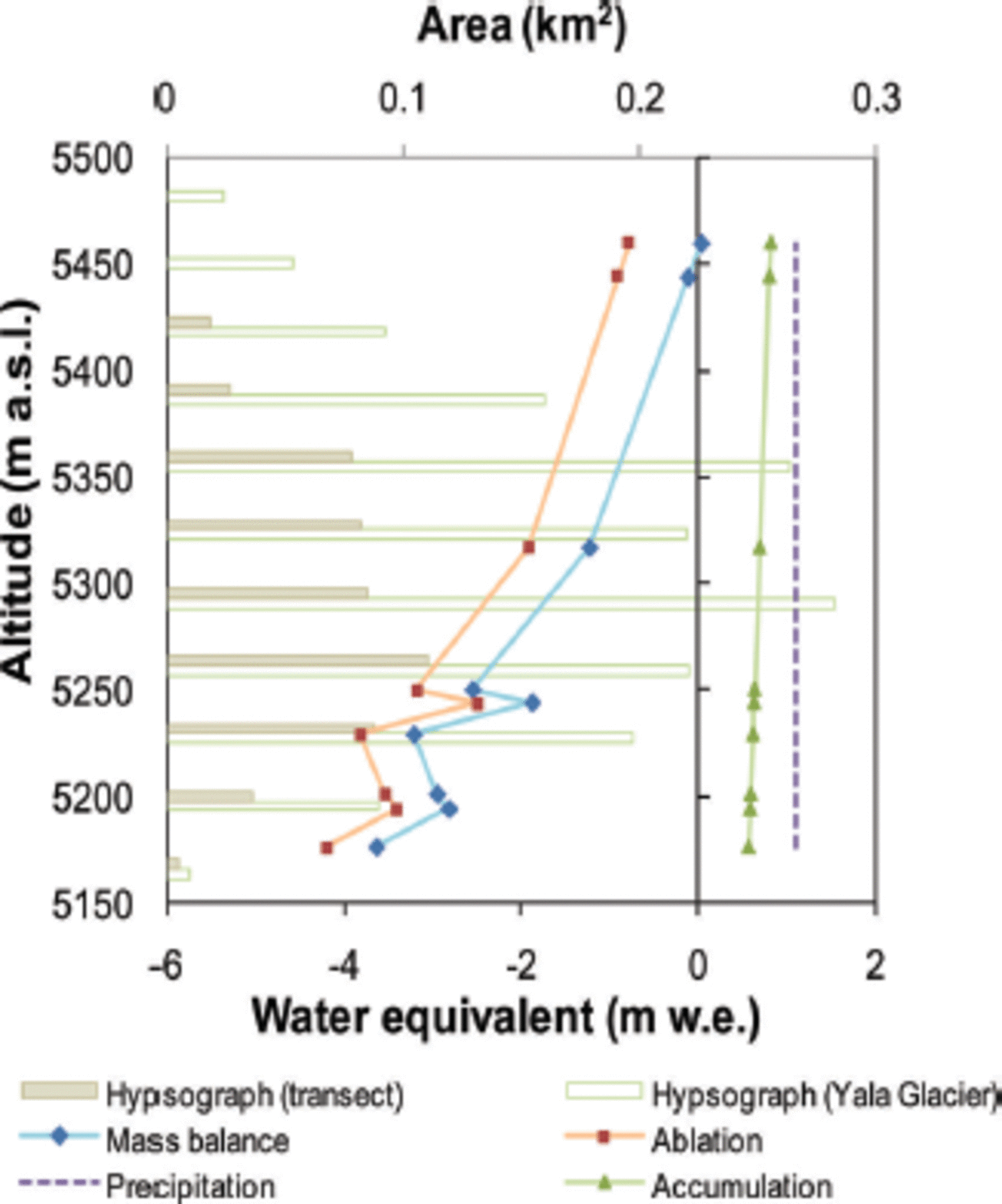
Fig. 4. Hypsograph of Yala Glacier and the observed section of the glacier based on ASTER DEM of 30 m resolution. Altitudinal distribution of accumulation, mass balance, ablation and precipitation on Yala Glacier from10 November 2 0 1 1 to 3 November 2012.
5. Conclusions
The calculated mass balance of the Yala Glacier transect from 10 November 2011 to 3 November 2012 is –0.89m w.e. The large negative mass balance we have found is consistent with the lower (more negative) end of the range of mass-balance values obtained, using an energy-/ mass-balance model, for recent years up through 2010 and reported by Reference Fujita and NuimuraFujita and Nuimura (2011). Thus, the 2010/11 mass-balance year may be a continuation of a secular trend toward more negative mass balances. Yala Glacier is in strongly negative mass balance in recent years compared with the 1990s. The ELA of the section is calculated at 5455 ma.s.l., which is consistent with a continuation of the rising ELA trend modeled by Reference Fujita and NuimuraFujita and Nuimura (2011) for the more recent years of their study up through 2010. Distinct diurnal cycles of temperature and precipitation occur at different stations in the valley. The mean temperature lapse rates for the entire valley floor (1396–3981 m a.s.l.) and the upper valley floor (3539–3981 m a.s.l.) are –0.0050°C and –0.0054°C, respectively. The lapse rate during the monsoon is lower than during the other observation periods. The monthly precipitation amount in the valley increases at a rate of 15 mm(100 m)–1 from 1396 to 2492 ma.s.l. It decreases at a rate of 24 mm (100 m)–1 from 3539 to 3875 ma.s.l. It starts to increase again at a rate of 6mm(100 m)–1 from 3981 to 5100ma.s.l. These conclusions are, however, just the preliminary results of a comprehensive scientific study initiated by the CMP which aims to yield multi-year hydrological, meteorological and glacio-hydrological observations in the glacierized Langtang River basin that can be of great use in determining the eventual state of the cryosphere of the Himalayan region.
Acknowledgements
We are very grateful to the HKH Cryosphere Monitoring Project implemented by the International Centre for Integrated Mountain Development (ICIMOD) and supported by the Norwegian Ministry of Foreign Affairs. We also thank the project partners for help in carrying out this study, including the Himalayan Cryosphere, Climate and Disaster Research Center, Kathmandu University; the Central Department of Hydrology and Meteorology, Tribhuvan University; the Department of Hydrology and Meteorology, Government of Nepal; and the Water and Energy Commission Secretariat, Government of Nepal. We are very grateful to the Third Pole Environment (TPE) Program of the Institute of Tibetan Plateau Research, Chinese Academy of Sciences, and Koji Fujita of Nagoya University, Japan, for providing us with the stake data. We thank the anonymous referees and the editor, D.R. MacAyeal, for constructive comments and suggestions.


