


Introduction
The question whether glaciers and ice sheets rest on bedrock, on loose sediments or on a mixture of both affects subglacial hydraulics (Reference Boulton and CabanBoulton and Caban, 1995) and corresponding aspects of glacier-flow dynamics, such as subglacial bed deformation (Reference Piotrowski and KrausPiotrowski and Kraus, 1997) and basal sliding (Reference Blake, Fischer and ClarkeBlake and others, 1994). Moreover, increasing areas of former glacier beds become exposed as a consequence of secular glacier retreat at a global scale due to atmospheric warming. Characteristics of such newly exposed glacier beds greatly influence sediment flux in meltwater streams, the formation of potentially dangerous moraine lakes (Reference Clague and EvansClague and Evans, 1994), debris-flow activity on steep morainic slopes (Reference Haeberli, Wegmann and Vonder MuhllHaeberli and others, 1997), revegetation patterns, permafrost aggradation—degradation (Reference Kneisel, Haeberli and BaumhauerKneisel and others, 1997; Reference Maisch, Wipf, Denneler, Battaglia and BenzMaisch and others, 1999) and landscape evolution in general. For these reasons, information about glacier-bed characteristics is of scientific interest, as well as of practical use. Such information, however, should not only be available for a few well-studied glaciers, but for representative samples if not the totality of glaciers in individual mountain ranges.
Subglacial investigations of mountain glaciers are difficult and limited in number. Besides exceptional cases of direct access through galleries for hydro-power production (Reference Bezinge, Perreten and SchaferBezinge and others, 1973; Reference Vivian and ZumsteinVivian and Zumstein, 1973; Reference Wold and ØstremWold and Østrem, 1979), sophisticated technologies such as borehole cameras (Reference Engelhardt, Harrison and KambEngelhardt and others, 1978) and various probes (plowmeters, etc.; Reference Fischer and ClarkeFischer and Clarke, 1994, Reference Fischer and Clarke1997) lowered to the bottom of boreholes can be used for investigating the uppermost layer of subglacial sediments. Quantitative geometric data about extended parts and, especially, the thickness of the entire subglacial sediment package is only available from electrical resistivity soundings with electrodes directly placed at the ice—bed interface (Reference Haeberli and FischHaeberli and Fisch, 1984; Reference Brand, Pohjola and HookeBrand and others, 1987). A statistically significant database on glacier-bed characteristics must, therefore, be created from other sources of information. Glacier forefields with recently exposed glacier beds are such an easily accessible source of information. This information from glacier forefields will be used in the following to estimate the frequency of occurrence of sedimentary and rocky glacier beds. Data from a systematic description of glacier forefields in the completely revised Swiss glacier inventory (Reference Maisch, Wipf, Denneler, Battaglia and BenzMaisch and others, 1999) is being compared with an algorithm for estimating bed characteristics (Reference HaeberliHaeberli, 1986; Reference WenzelWenzel, 1992) applied to glacier-inventory data (cf. Reference Haeberli and HoelzleHaeberli and Hoelzle, 1995, for parameterizations of inventory data from the European Alps).
Characteristics of Glacier Forefield Geomorphology
One of the glacier-related projects within the framework of the National Research Program (NRP 31) on “Climate Changes and Natural Catastrophes”, carried out from 1992–97, was aimed at the reconstruction and homogeneous parameterization of the AD1850 glacier situation (the last main advance period of the Little Ice Age) in the Swiss Alps. More than 2000 glaciers have been recorded in the new CH-INVGLAZ dataset. Statistical comparison with present-day glacierization, based on the Swiss glacier inventory of 1973 (MüReference Muller, Caflisch and Mullerller and others, 1976), provides a complete synopsis of various glaciological and geographical aspects relating to long-term glacier retreat since AD1850 (Reference Maisch, Wipf, Denneler, Battaglia and BenzMaisch and others, 1999). Besides glaciological parameters, a detailed and standardized geomorphological classification of the forefield areas, not usually contained in glacier inventories, was also included (Fig. 1)

Fig. 1. Classification of the nine forefield types applied to the Swiss glacier inventory CH-INVGLAZ and the three forefield groups A (sedimentary), B (mixed) and C (rocky) used (for more detail on the classification criteria, see Reference Maisch, Wipf, Denneler, Battaglia and BenzMaisch and others, 1999).
Nine different forefield types were identified, each with special moraine characteristics. These ranged from multilayered morainic systems of impressive vertical height and debris thickness (type A) to nearly debris-free and strongly eroded rock beds (type C) also including several mixed situations with sedimentary-rocky beds (type B). The most frequent sedimentary types (50.9%) are often characterized by broad and steep morainic aprons at the 1850 ice front (types A-II and A-III). Where affected by permafrost, such types are frequently connected with active rock glaciers originating directly from morainic material (type A-II).
The forefield types are clearly correlated with glacier type, glacier size and glacier shape. Alpine glaciers in general show a strongly asymmetric distribution of size categories. Mean glacier size in 1973 in the Swiss Alps is 0.770 km2 (1.056 km2 in 1850) and nearly 80% are <0.5 km2. Only 19 glaciers have surface areas > 10 km2, the Grosser Aletsch- gletscher (Valais) at 96.1 km2 being the largest as well as longest glacier in the Alps.
First Application of Erosion-Sedimentation Index
Individual glaciogenic forms and landscapes are mainly influenced by glacier geometry and temperature conditions at the glacier bed (Reference Sugden and JohnSugden and John, 1976; Reference Sollid and SørbelSollid and Sørbel, 1994). On the other hand, the sediment balance of the catchment determines whether erosion or sedimentation results as the net effect of the involved processes. In the case of ice sheets, debris production and redistribution takes place at the bed by abrasion, plucking and sediment deformation (Reference BoultonBoulton, 1996), whereas the major debris contribution to mountain glaciers is provided by frost weathering in, and rockfalls from, surrounding rock walls (Reference HaeberliHaeberli, 1996). The sediment balance of a glacierized mountain catchment, i.e. the ratio between debris input from the surrounding rock walls and debris evacuation by the meltwater stream, cannot be measured directly. The main factors influencing the governing processes have been organized by Reference HaeberliHaeberli (1986) into an index (I es) of glacier erosion and sedimentation (Fig. 2), which discriminates between glaciers eroding into bedrock and those building up sedimentary beds:
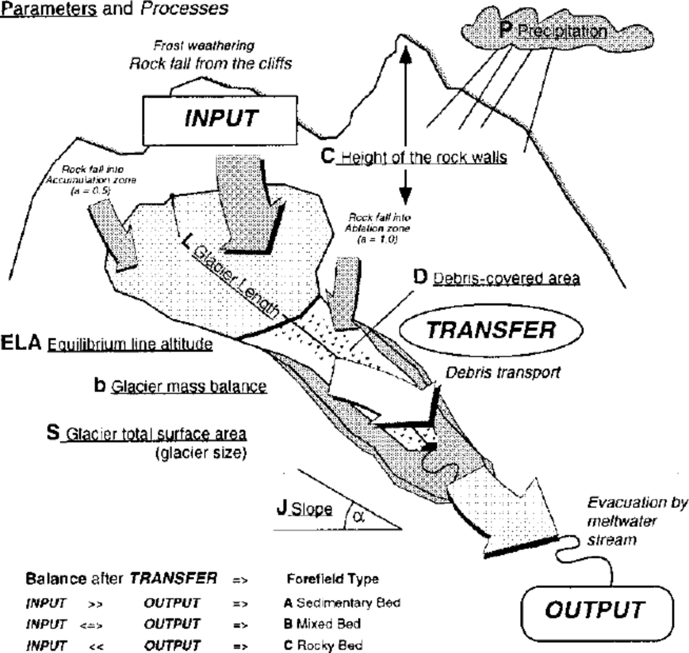
Fig. 2. Scheme explaining the erosion—sedimentation index (Ies), the processes and parameters involved.

where α · C represents debris production in which α is a factor indicating whether debris is furnished to the ablation area (1.0) as well as to the accumulation area (0.5) and C is the mean height of debris-providing cliffs (100 m); (P — b) · S · J k reflects the transport capacity of the melt- water stream where P is the annual precipitation (m), b is the annual glacier mass balance (m), S is the total surface area of the glacier (km2), J is the inclination of the sub-/ proglacial meltwater stream (tan a) and k is a constant from river hydraulics (1.6); L is the glacier length (km). The units in this ratio of factors have no physical meaning and are chosen so that numbers around 1 result.
A sample of 36 glaciers in the Valais and Bernese Alps, classified according to Equation (1), shows a distinct pattern in the three glacier-bed categories with only small overlapping boundaries on the Ies axis (Fig. 3; Reference HaeberliHaeberli, 1986). Such a simple approach only enables rough assessment of glacier- bed characteristics as tested with observations in glacier forefields exposed during 20th century glacier shrinkage (Reference Kienholz, Fitze, Maisch, Haeberli, Leser, Monbaron, Walker and GrabauKienholz and others, 1993; Reference WenzelWenzel, 1992).
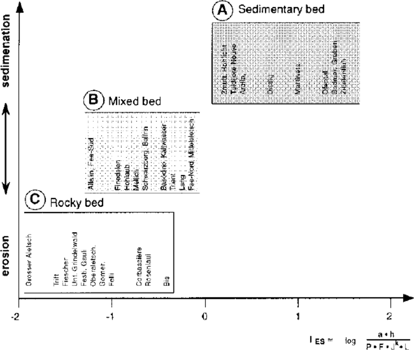
Fig. 3. Glacier-bed characteristics and Ies values from selected glaciers in the western Swiss Alps (modified from Reference HaeberliHaeberli, 1986).
However, the classification clearly illustrates that a combination of factors must be taken into account and that the entire system with its input, transfer and output should be considered in order to understand why some glaciers erode into bedrock and others do not. The ratio between cliff height and the product of surface area times slope is crucial and easily explains why thick moraine beds are usually built up by short glaciers, why steep glaciers and glaciers without debris- providing rock walls have rock beds, or why calving glaciers terminate on moraines as long as they are not unstably retreating through deep water (Reference Meier, Rasmussen and MillerMeier and others, 1985)
Determining the erosion—sedimentation index requires consideration of debris-providing cliffs around the glacier. This information is not available in glacier inventories (Reference Haeberli, Bösch, Scherler, Østrem and WallenHaeberli and others, 1989) and, so it is impossible to apply a corresponding algorithm to great numbers of roughly parameterized glaciers. Many detailed glacier inventories, however, do contain information about the debris-covered parts of glaciers. The amount of debris-covered ice is a function of debris concentration within the ice which depends on sediment input to the glacier which is related to annual snow accumulation (glacier area times annual precipitation).
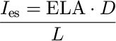
On glaciers with small and steep accumulation areas, rock falls can reach far into the firn area. Such glaciers contain debris throughout their ice thickness and have major parts of their ablation areas covered by debris. Where the transport capability of the meltwater stream is insufficient to evacuate the debris, these debris-covered glaciers are likely to rest on sedimentary beds. Therefore, it can be assumed that a combination of glacier-inventory variables will correlate statistically with glacier-bed characteristics observed in recently exposed glacier forefields. Reference WenzelWenzel (1992) has found a best, and highly significant, correlation between debris-covered area (D, % of total glacier surface area) times equilibrium-line altitude (ELA, based on an accumulation-area ratio of 0.67 divided by glacier length, L), and the forefield characteristics of the Matter and Saas valleys, Valais Alps:
In this relation, ELA (100ma.s.l.) reflects the continentality of the climate (precipitation ≥ debris concentration), whereas L (km) stands for the spreading-out and, hence, average thickness of the morainic material.
Relation (2) is now applied to the entire set of Swiss glaciers and compared with directly observed and classified forefield characteristics.
Comparison of the Two Approaches
To compare and test the proposed new inventory index model, the previously described nine original forefield classes were reduced to three main characteristic glacier beds. Type A (sedimentary, 50.9%) contains most of the glacier forefields in the Swiss Alps (total sample n — 1640), followed by the mixed (type B: 25.6%) and rocky beds (type C: 23.5%). This classification procedure is a strong simplification of natural variability; the forefield classes A-B-C used in this study do not show exact boundaries so overlap each other.
The geographical distribution of the simplified forefield categories can be seen in Figure 4. Because of lack of data or unhomogeneously recorded parameters, the sample of index values was finally reduced to n = 809 glacier forefields. For every glacier, the new erosion—sedimentation index was calculated with Equation (2) and displayed in a scatter plot including the amount of debris cover (D) vs ELA/L as recorded in the 1973 Swiss glacier inventory (Fig. 5).

Fig. 4. Regional distribution of rocky, mixed and sedimentry beds in the Swiss Alps..

Fig. 5. Scatter plot of debris-covered glacier surface area (D) versus ELA/L (glacier length) with areas of rocky, mixed and sedimentary beds indicated.
The initial spatial and statistical analysis shows the following trends:
The abundance of small mountain glaciers (or even glacierets), mostly in small cirques, makes the sedimentary type A of glacier forefield beds the most common (cf. Figs 1 and 4).
Rocky beds (type C) occur more frequently in the western parts of the Swiss Alps (Bernese and Valais Alps). The eastern part of the Swiss Alps (Grisons), generally with lower mountains and smaller glaciers, is predominantly characterized by sedimentary (type C) and mixed beds (type B).
The widely scattered distribution in Figure 5 shows a high variability of the Swiss glaciers and their forefield geomorphology. This is the result of the large individual variety of Alpine glaciers, their long Holocene history (from 10 000 yrs BP up to now) and the diversity of the environmental factors which control the forefield-forming processes (topography, glacier type, glacier size, orientation, shape of the rock headwall, geology, rock type, weathering etc.).
All three types (A, B, C) display a wide range of variation, having almost one-third of the index values at the zero point (I es = 0). This is because the inventory parameter “exposed glacier surface area” is 100% (or debris cover is 0%) in n — 264 observations (32.6%). In such cases, with no debris cover on the glacier surface, no differentiation of the forefield types can be made.
The statistical means of the I es values are centred on 1000 (961 ±1596) for sedimentary beds, 250 (253 ± 435) for mixed beds and 170 (169 ± 416) for rocky beds. This general trend reflects the influence of the key parameters used for the index calculation (Fig. 6). However, all three types have large and overlapping standard deviations, making it very difficult to assign a distinct classification level for prediction.

Fig. 6. Box plots with statistical characteristics of the erosion- sedimentation index (above) and the debris cover (below).
Rocky beds (type C) are restricted to an index-range smaller than 3000 and <50% debris cover. This forefield type can be excluded in cases of higher index values or debris-cover percentages.
Mixed beds (type B) are common in the same range with I es values < 3000 but can be observed with debris covers up to 75%.
Sedimentary beds (type A) occur along the entire index axis from 0 up to nearly 10 000 and with debris-cover values from 0–90%. Indices >3000 are, however, exclusively restricted to sedimentary beds. In this range, highly reliable predictions can be made. It is especially interesting to note that even debris-free glaciers can rest on thick sedimentary beds. Small glaciers on top of large rock glaciers are characteristic in this situation (glaciers related to rock glaciers are typically debris-free and not debris-covered as often assumed). Periglacial debris production and transportation (rock falls, permafrost creep), during periods of glacier retreat, may have a strong influence in such cases.
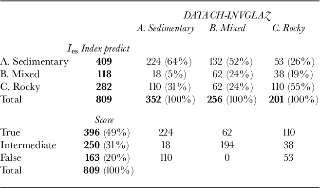
In order to test the index model with the real forefield classification from the CH-INVGLAZ dataset, several distinct index boundary values were chosen to establish the best prediction model. The best result (nearly 50 per cent of correctly classified forefields), with limits of 15 and 100 respectively, can discriminate between rocky beds (type C: index < 15), mixed beds (type B: index 15–100) and sedimentary beds (type A: index >100).
The scores from the new index-classification model are summarized in Table 1. Overall, 48.9% of the predictions were true (n = 396), 30.9% were of intermediate quality (n = 250) and 20.1% were false (n = 163). In general, sedimentary and rocky beds have been slightly overestimated with this model. The question remains open as to which additional parameters should be taken into consideration to increase the score of true predictions with this model.
Table 1. Score of the prediction model used (Ies boundaries of 50 and 100) compared to the classification of the Swiss glacier inventory used in the CH-INVGLAZ dataset.
Conclusions and Perspectives
This comparison of an index for estimating glacier-bed characteristics from glacier-inventory data with directly observed glacier forefield types reveals general trends, but with considerable scatter. Unambiguous predictions can only be made in cases of extremely high index values and debris-cover percentages reflecting sedimentary beds; the existence of rocky beds can be excluded outside critical values of the corresponding variables. Debris-free glaciers can rest on thick sedimentary beds, possibly built up by periglacial debris-transport processes during times of limited glacier extent. More detailed analysis and three-dimensional consideration of the data (GIS, digital terrain information) are necessary in order to improve the predictability of glacier-bed characteristics.


