


Introduction
Stable isotopes and ions are useful tracers in glaciological and hydrological research (Reference DansgaardDansgaard, 1964; Reference Moser, Stichler, Fritz and FonteMoser and Stichler, 1980; Reference Stichler and Orville-ThomasStichler, 1987; Reference Wagenbach, Oeschger and LangwayWagenbach, 1989; Reference Kendall and McDonnell.Kendall and McDonnell, 1998). They provide information about the influence of atmospheric circulation patterns on the chemical composition of the snowpack (He and Theakstone, 1994), changes of snowpack chemistry through the melting period (Reference Shanley, Kendall, Albert, Hardy and snowpackShanley and others, 1995; Reference Raben and TheakstoneRaben and Theakstone, 1998; He and others, 2001a, b), the contributions made by snow, ice and rainfall to glacier-river discharge (Theakstone, 1988; Reference Theakstone and KnudsenTheakstone and Knudsen, 1989), and the water entering the system from glacier surface, in-glacial and subglacial drainage systems (Reference Theakstone and KnudsenTheakstone and Knudsen, 1996; Reference Tranter, Brown and Gurnell.Tranter and others, 1996).
Stable-isotope studies have been carried out on the Qinghai–Tibetan Plateau since the early 1990s (Yao and others 1991; Zhang and Yao, 1995; Tian and others, 1997). on the precipitation-rich part of the southern Qinghai–Tibetan Plateau, especially in the intense-monsoon-climate stable isotopes in precipitation (represented by δ18O values), precipitation amount and air temperature are inversely related. the amount of precipitation is higher in summer, as air masses mainly originate from moisture-rich maritime sources. They become more depleted of heavy isotopes along the transportation routes from ocean to continental precipitation sites.
Thus, the lower stable-isotopic values correspond to higher precipitation amount and high temperature in summer (Reference DansgaardDansgaard, 1964; Reference Rozanski, Araguás-Araguá, Gonfiantini, Swart, Lohmann, McKenzie and SavinRozanski and others, 1993). In winter, however, when air masses mainly come from closer continental sources, precipitation amount and temperature are lower, and the δ18O values of precipitation are higher. Kang and others (2000) noted that the irregular pattern of isotopes of precipitation is dominant in the Himalaya and southern regions of the Qinghai–Tibetan Plateau. In contrast, there is a marked positive correlation between the δ18O values of precipitation and air temperature on the northern part of the plateau, where air masses for precipitation mainly originate from continental sources (Hou and others, 1999). Air temperature appears to be the controlling factor in temporal fluctuations of δ18O values in the northeastern part of the plateau (Kang and others, 2000).
Twenty-two per cent of the glaciers in the large glacier-covered areas of western China are temperate glaciers (``maritime-type glaciers’’), but few studies have been made of stable isotopes in China’s monsoon temperate-glacier region. In order to fill the gap, the first research programme of ice-core drilling at Baishui glacier No. 1was carried out in summer 1999 (He and others, 2000). the isotopic variations down to a below-surface depth of 7.8 m correlate roughly with variations of winter temperature and precipitation in the most recent 5 years (He and others, 2000). At the same time as the coring was carried out, samples of accumulated snow, glacial meltwater, summer rain and glacier-fed river water were collected at and around the glacier. Investigations were continued in July 2000, when more detailed sampling was undertaken. the results of investigations in both 1999 and 2000 are reported and discussed here.
General Situation In the Study Area
Yulong mountain, located in the Hengduan range (south-eastern edge of the Qinghai–Tibetan Plateau), north of Lijiang, Yunnan province, China (27˚10’–27˚40’ N, 100˚07’– 100˚10’ E), is the southernmost glacierized area in Eurasia (Fig. 1). the climate of the high-altitude area (>4100m a.s.l.) onYulong mountain, which is controlled by the South Asia/ Indianmonsoon, has provided the cold, moist conditions necessary for glacier development. the 19 glaciers on Yulong mountain cover 11.61km2. Their high accumulation and ablation, high temperatures, basal sliding and rapid movement are typical of subtropical temperate glaciers (Li and Su, 1996). Thelargest glacier, Baishui No.1, has an area of 1.52 km2 and is 2.7 km long (Fig. 1). Its broad, flat accumulation area covers about 1.0km2 at 4800–5000ma.s.l. the glacier terminates at about 4150ma.s.l.. Its tongue is heavily crevassed, reflecting very active motion. Glacial meltwater flows to the Baishui river, within the upper Yangtse river basin.
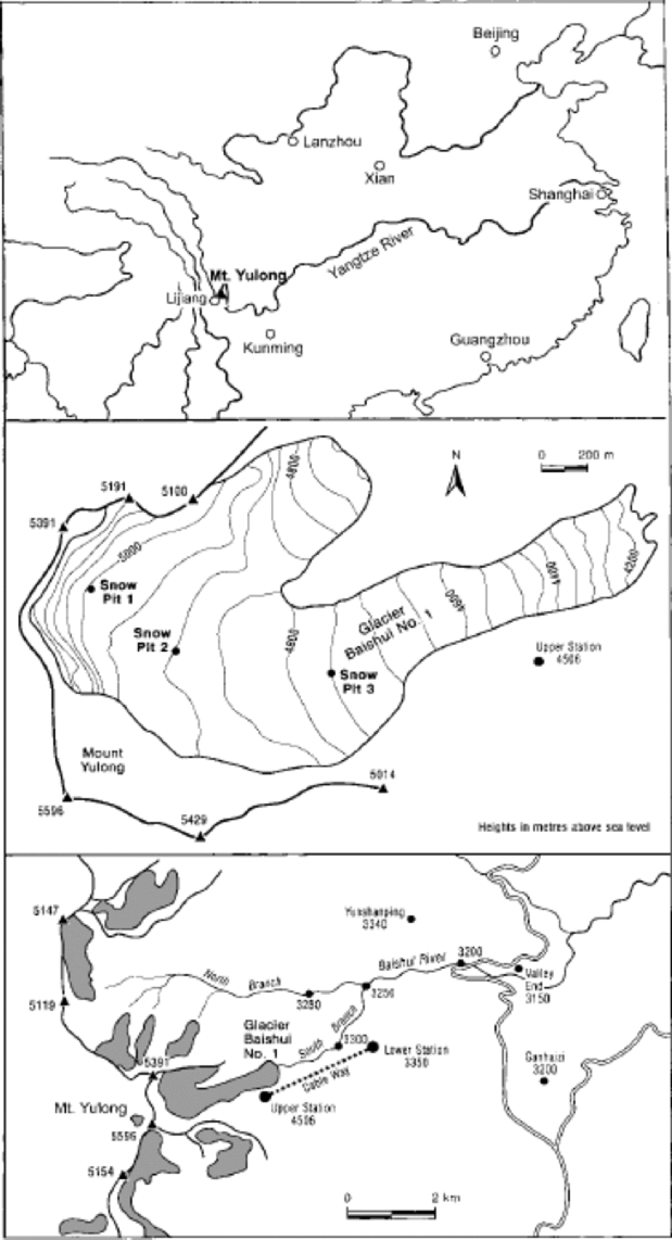
Fig. 1 Sketch maps indicating the location of Yulong mountain in southeastern Asia (a), Baishui glacier No. 1, with the locations of snow pits used in 2000 (b), and the area around Yulong mountain, with precipitation and river-water sampling sites (c).
Yulong mountain, with a highest peak, Satseto, of 5596 m, is in the subtropical zone. Seventy per cent of the region’s precipitation falls between June and September from the warm, moisture-rich air masses of the prevailing southwestern summer monsoon from the Indian Ocean. In winter, the climate is relatively dry, controlled by the winter monsoon of closer continental origin. Themulti-year mean annual precipitation at Lijiang meteorological station (2393ma.s.l.) is 772 mm, and the 4 year average at the mountain foot (3240ma.s.l.) is 1646mm (Su and Pu, 1996). A snow–firn core acquired in 1999 at around 4950ma.s.l. indicated a 4 year mean annual net accumulation of 900 mmw.e. (He and others, 2001a). Since the measured net accumulation is the only data obtained in relation to the atmospheric precipitation above 4800 ma.s.l. on Yulong mountain, it is assumed to represent an ``average’’ rate in the glacier’s accumulation area, although values at other sites may be different. Using the mean net accumulation rate recovered in the core, together with the ablation rates measured by Su andWang (1996), the estimated mean annual precipitation in the accumulation area (>4800ma.s.l.) of the glacier is 2400 –3100 mm (He and others, 2001b). However, the precipitation in the glacier’s ablation area at 4150–4800ma.s.l. is still unknown. Themean annual temperature at Lijiang is 12.6˚C, with a positive mean temperature in every month. At 5400 ma.s.l. the mean annual temperature is about –7.5˚C, and all monthly mean temperatures are <0˚C. the mean annual temperature above the equilibrium line (4800–5000ma.s.l.) is –3.3˚ to –4.7˚C (Wang, 1996). This suggests an adiabatic lapse rate of about 0.7˚C per 100m, which is higher than that for a pure maritime area because Yulong mountain is distant from the Indian Ocean, under the monsoon climate of wetter summers but drier winters.
1999 Results and Discussion
In July 1999, samples of recently deposited snow, summer rain, supraglacial and subglacial meltwater were collected from Baishui glacier No. 1, and river water samples were collected from the glacier-fed Baishui river.The sampleswere collected at the field sampling sites (Fig. 1). Each sample of snow and ice was melted at about 20˚C in a clean plastic bag, and the meltwater and other water samples were poured into pre-cleaned high-density polyethylene bottles; the bottle top was sealed with wax to prevent evaporation or diffusion. Bottled samples were transported to the Laboratory of Ice Core and Cold Regions Environment, Chinese Academy of Sciences, and kept in a cold room at –20˚C until δ18O, Na+, Ca2+, Mg2+, Cl–, conductivity and pH values were determined using a Finngan MAT-252 Spectrometer (precision 0.5‰), Dinex-100 chromatography (precision 0.1%), a 2380 Atomic Absorption Spectrophotometer (precision 0.2%), conductivity and pH meters. the results are shown in Figures 2–4.
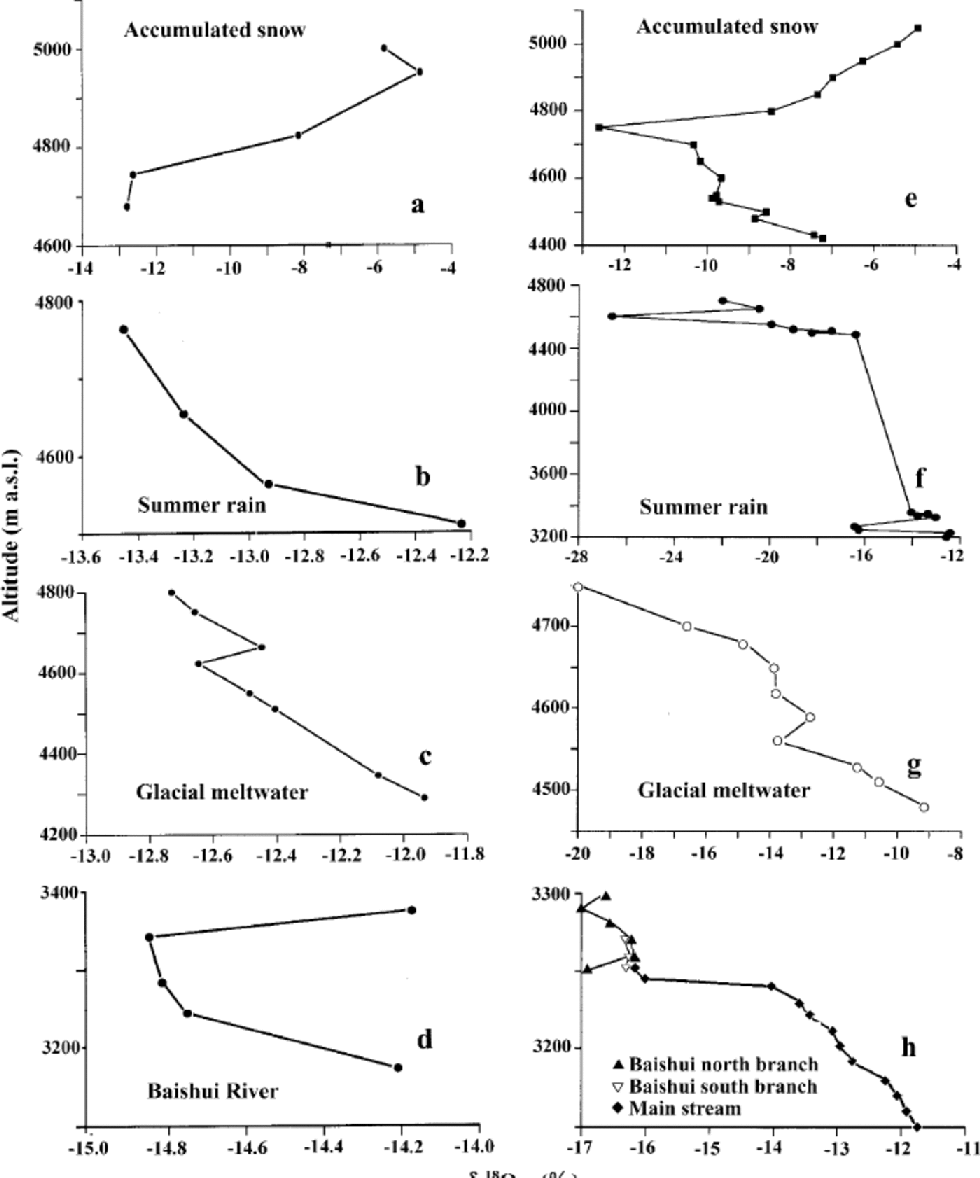
Fig. 2 Altitudinal variations of δ 18O values in accumulated snow, summer rainfall and glacial meltwater at Baishui glacier No. 1, and in glacier-fed river water, July 1999 (a–d) and July 2000 (e–h).

Fig. 3 Altitudinal variations of Ca+,2Cl–, K+, Na+, Mg2+, SO4 2–, conductivity and pH values in accumulated snow, summer rainfall and glacial meltwater at Baishui glacier No. 1, July 1999.

Fig. 4 Ionic variations in the glacier-fed Baishui river, July 1999.
The δ18O values of the three samples of snow deposited during the same winter that were collected above the equilibrium line (4800m) were much higher than those of the two samples collected below it (Fig. 2). These high-altitude winter-deposited snow samples were more enriched in the heavy isotope than any other samples (e.g. recently deposited (1month) snow and summer rain) obtained during the 1999 study. the general increase of δ18O values with altitude (Fig. 2) indicates an irregular and varied spatial pattern, contrasting with the situation in the northern Qinghai–Tibetan plateau (Yao and others, 1991), in this monsoon-dominated region.
Four samples of summer rainfall were collected at Baishui glacier No. 1 during a single precipitation event in July 1999. There was a trend of increasing δ18O values with decreasing elevation (Fig. 2), but the range was low (1.23‰). the δ18O values of precipitation samples collected during a single event may differ, and their average value depends strongly on the meteorological situation at different altitudes of the air in which it is produced and through which it falls (Reference Rozanski, Araguás-Araguá, Gonfiantini, Swart, Lohmann, McKenzie and SavinRozanski and others, 1993). Accordingly, the slight differences of δ18O values in this single summer rain event are caused by the different climatic conditions at varied elevations. A decrease in δ18O values with rising altitude corresponds to an increase in precipitation amount and a decrease in temperature with increasing altitude, indicating a complicated isotopic variation during the single precipitation.
Eight meltwater samples were collected in the glacier’s ablation area. Their δ18O values tended to increase with decreasing altitude, but the range was small (0.80‰). In general, the samples were less depleted of 18O than were the rainfall samples (Fig. 2). the δ18O values of the samples from the Baishui river varied only slightly from a mean of –14.56‰, suggesting that glacial meltwater was mixed with water which was more depleted of the heavy isotope.
Variations of dissolved ions in the different sources of supply to, and output from, a glacio-hydrological system reflect their different origins. Most of the ions in the accumulation area of Baishui glacier No. 1 probably came from nearby sources: (1) wind-blown crustal materials from the mountain slopes, (2) impurities carried by moist air moving up the slopes, (3) avalanches from the valley walls, and (4) contact with the glacier bed by flowing ice and meltwater. Ionic concentrations in rainwater were low, particularly at high altitude (Fig. 3), and it is apparent that the impurity content of the precipitation falling on Baishui glacier No. 1 was small. Solutes are acquired by meltwater and glacier river water as a result of contact with other sources. the increase in contact area between meltwater and the glacier bed with decreasing altitude led to higher ionic concentrations in the meltwater and the Baishui river (Fig. 3 and 4). the increase of Cl– indicates gradual absorption of dissolved chloride from bedrock and till.
In most of the samples collected in 1999, Ca2+ and Mg2+ concentrations were much higher than those of Na+ and K+ (Fig. 3). Ca2+ inputs to the Baishui glacier No. 1 catchment probably are dominantly from local (continental) sources. K+ may originate from continental dust sources. Mg2+ has marine as well as continental sources. the data suggest that the impurities deposited in the glacier’s system were mainly of a continental origin. Concentrations of Mg2+, Ca2+ and K+ were higher in snow at high altitude than in that closer to the equilibrium line, but Na+ and Cl– concentrations were lower at higher altitude. In general, the elution of Ca2+ and Mg2+ from a snowpack is more rapid than is that of Na+ and K+ (Reference Davies, Jones and Orville-ThomasDavies and others, 1987). Thus, the decrease of ionic concentrations with decreasing altitude in the surface snow at Baishui glacier No. 1 may be the result of a longer period of melting at lower elevations. However, this cannot account for the pattern of Na+ and Cl– concentrations. SO4 2– was detected in surface snow only at the highest site (5000m). Most SO4 2– in snow is removed relatively rapidly in the early part of the melt season, and concentrations decrease particularly quickly at lower altitudes, where melting starts earlier (Reference Raben and TheakstoneRaben andTheakstone, 1994). Early-season ionic elution of snow results in meltwater with a high ionic content. This has readily observed effects on river water (Reference Tranter, Jones and Orville-ThomasTranter and others, 1987). the supraglacial meltwater formed from the leached snow is depleted of SO4 2– (Reference Tranter and RaiswellTranter and Raiswell, 1991). SO4 2– was detected in meltwater at Baishui glacier No. 1 only at lower altitudes; the concentrations were higher than in the one sample of summer rain in which SO4 2– was found (Fig. 3).
Concentrations of both SO4 2– and NO3 – were much higher in the Baishui river than in the sources at higher altitudes, and they tended to increase as altitude decreased downstream (Fig. 4). This indicated that ionic enrichment occurred as a result of reactions with other materials. Reference Hasnain and ThayyenHasnain and Thayyen (1999) believe that increased SO4 2– concentrations in river water discharging from Dokriani Glacier, Garhwal Himalaya, India, resulted from enhanced weathering of moraines by monsoonal rainfall.
Differences of conductivity of the samples of surface snow, rainfall and meltwater reflected the general trends apparent in the concentrations of individual ions (Fig. 3).
2000 Results and Discussion
Sampling in the Yulong mountain area in 2000 was more detailed than in 1999. δ18O of all samples was analyzed with a new Delta Plus mass spectrometer in the Laboratory of Ice Core and Cold Regions Environment.
δ18O values in precipitation
The δ18O values of winter accumulated snow, collected at the surface above 4800ma.s.l. on 5 July, decreased with decreasing altitude (Table 1; Fig. 2). However, the δ18O values of a set of samples from about 30 mm of newly precipitated snow, collected at 4400–4750ma.s.l. on 10 July when the temperature was lower (–5–0˚C), decreased with increasing altitude. the samples of surface snow from above 4800m represent a winter precipitation event, and those from new accumulated snow below 4800m represent a summer precipitation event. the δ18O values indicate different patterns of variation for winter and summer snowfalls.
Table 1. Mean δ 18O values in snow, meltwater, rain and glacier river water at Baishui glacier No. 1, July 2000

Samples of summer rain were collected during a single precipitation event with a higher amount of precipitation (50mm on average). Air temperature during sampling at 4700–3200ma.s.l. was 10–20˚C. Summer rain was much more depleted of 18Othan were the winter and summer snow covers (Fig. 2). Four rainfall samples were collected at each of four locations (Fig. 2): Ganhaizi (3200–3270m), the lower cableway station (3330–3360m), the upper cableway station (4490–4520m) and the glacier (4550–4700m). the δ18O values were highest at Ganhaizi, where precipitation amount was lowest. the lowest values were for the samples collected at 4600–4700m, where precipitation amount was highest.
It is apparent that below 4800ma.s.l. the higher δ18O values of summer snow correspond to lower-temperature conditions, and the lower values of summer rain correspond to higher-temperature conditions. the lowest values of summer-deposited snow at 4650–4750ma.s.l. and of summer rain at 4600–4700ma.s.l. (Fig. 2) suggest the likely existence of a highest-precipitation-amount zone at 4600–4750min the glacier area. This irregular and varied pattern is characterized by an obvious reverse relation between δ18O values and temperature/precipitation amount in the prevailing summer monsoon period when samples were collected.
δ18O values in snow pits
Several days after the surface snow samples were collected, three pits were excavated in the accumulated snow on Baishui glacier No. 1, at 5000,4900 and 4750ma.s.l. (Fig. 1). Some melting occurred at the lowest site in the intervening period, but about 10 mm of new snow accumulated there. the amplitude of the isotopic variations at each pit site reflected the changeable climatic conditions during the period of snow accumulation. the δ18O values of most of the samples were higher than those of recently deposited surface snow and summer rain. It is apparent that snow deposited in winter, when precipitation amounts and air temperatures are lower, is less depleted of 18O than is summer precipitation (Fig. 2 and 5).
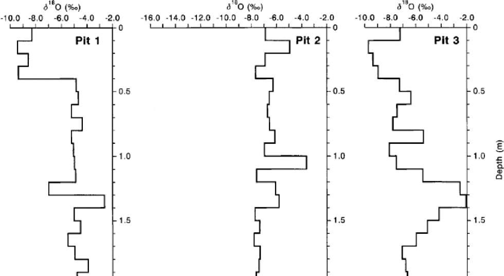
Fig. 5 δ 18O values of snow samples in three pits excavated at Baishui glacier No. 1, July 2000. Pit 1 was at 5000 m a.s.l., pit 2 at 4900 m a.s.l., and pit 3 at 4750 m a.s.l.
The highest site (pit 1, Fig. 1), at 5000 m, was excavated to a below-surface depth of 2.6 m.The mean δ18O value of the 26 samples was –5.49‰, and the coefficient of variation, a measure of the degree of heterogeneity, was –0.303. the uppermost 0.4m of the snow cover was more depleted of 18Othan was that beneath (Fig.5). the maximum δ18O value (–2.65‰) was at 1.3–1.4m depth. Pit 2, at 4900 m (Fig.1), was taken to a depth of 3.1 m. δ18O values were generally lower than those at pit 1. the mean δ18O value of the 31 samples was –7.81‰, and the coefficient of variation was –0.346. the maximum δ18O value (–3.64‰) was at 1.0–1.1m (Fig. 5). 18O depletion of the lowest four samples was markedly greater than that of the overlying snow, and the mean δ18O value of the uppermost 2.7 m of the snow cover was –6.86‰ (coefficient of variation –0.136). Pit 3, at 4750ma.s.l. (Fig. 1), was 2.0m deep. δ18O values were more varied than in the two higher pits, with a maximum (–2.07‰) at 1.3–1.4m depth (Fig. 5). the mean of the 20 samples was –6.60‰ and the coefficient of variation was –0.308.
δ 18O values in glacial meltwater
Ten samples of glacial meltwater were collected at 4530– 4750 m. δ18O values displayed a general increase with decreasing elevation (Table 1; Fig. 2). the mean value (–13.94‰) was much lower than the means of winter-deposited snow (–9.46 ‰) and accumulated snow at the pit sites (–6.70‰), indicating that alternating isotopic depletion and fractionation occurred during the processes of snow–ice transformation, ablation, evaporation and supraglacial meltwater flow.
δ 18O values in the glacier-fed river
Water samples were collected from various sections of the glacier-fed Baishui river at altitudes of 3300–3150m. the mean of the five δ18O values of samples from the river’s southern branch was –16.59‰, and that of the three from the northern branch was –16.28‰ (Table 1; Fig. 2). Below the junction at 3250ma.s.l. (–16.09‰), values increased, suggesting that re-fractionation occurred during water flow, percolation, evaporation and contact with the river bed and ground-water. the highest δ18O value (–11.75‰) was at the valley’s end (Fig. 1). the mean value of the 20 Baishui river samples (–15.44‰) was between those of glacial meltwater (–13.94‰) and summer rain (–16.98‰), demonstrating that the river water was a mixture of glacial meltwater and sources more depleted of 18O, including summer precipitation. Ground-water may enter the river, and further sampling and analysis is needed to calculate the relative contributions of meltwater, ground-water and precipitation to river discharge. the spatial and temporal variations of stable isotopes in the river may be used to identify the different sources of supply.
Conclusions
Yulong mountain is in a strong monsoon-climate area, influenced by moist air of a more distant marine origin in summer and by drier continental air masses in winter. the spatial distribution of oxygen isotopes and ions in snow and summer rain shows an irregular and varied pattern of these signals of precipitation in the region. There is an inverse relation between δ18O values and precipitation amount/air temperature in winter-deposited snow and summer precipitation sampled in both 1999 and 2000. from the isotopic data collected in 1999 and 2000, it is inferred that Yulong mountain may have a zone of highest precipitation at 4600–4700m, as indicated by the lowest δ18O values of summer rain and snow.
The irregular spatial and temporal variations of the isotopic and ionic contents of snow, summer rain, meltwater and glacial runoff are controlled by varied monsoon climatic conditions on Yulong mountain. Both ionic changes and isotopic depletion or fractionation occur during processes of snow–ice transformation, meltwater formation and runoff, and contact with bedrock and till. However, the marked differences of δ18O values between winter-accumulated snow, glacial meltwater, summer precipitation and the glacier-fed river provide one of the best quantitative indices with which to differentiate between them. Variations of oxygen isotopes in glacier river water probably permit identification of different sources of supply, but this needs to be confirmed by more sampling and observation from each source of the river.
Sampling snow chemistry over a wide lateral and elevation range provides a basis for identifying discrete source areas and understanding the underlying processes responsible for the spatial variation in the chemical content of snow (Reference Lyons, Wake, Mayewski., Davies, Tranter and JonesLyons and others, 1991). on the southern margin of the Qinghai–TibetanPlateau, seasonal changes of dust transportation in the troposphere cause the highest Ca2+, Mg2+ and SO4 2– concentrations to occur in spring, with deposition during the peak dust storm activity, between mid-February and late May (Kang and others, 2000). At Baishui glacier No. 1, precipitation has a low impurity content. Most of the ions in the glacier’s accumulation area are likely to come from nearby sources carried by moist air moving up the mountain slopes under the monsoon climate which controls the study area.
Acknowledgements
The work reported here was supported by the Hundred-Talents Project (2002-43), Chinese Academy of Sciences, the Knowledge-Innovation Funds (210506 and 210019) from the Laboratory of Ice Core and Cold Regions Environment and the Cold and Arid Regions Environmental and Engineering Institute, the Chinese Natural Science Foundation (40071023) and the funds (KZCX-2-301 and G1998040800) from the Chinese Academy of Sciences. We are grateful for the support of the tourism company of Yulong mountain during the field seasons. SunWeizhen, ShengWenkun, Li Feng Xia andWang Xiaoxiang determined the δ18O, cationic, anionic, pH and conductivity values in the laboratory. We thank N. Scarle for assistance with the figures.


