


Introduction
Winds and ocean currents redistribute sea ice, thereby affecting the transfer of heat energy between the ocean and the atmosphere. Knowledge of ice kinematics can be used for synoptic-scale climatological research and for the validation of ocean-ice-atmosphere models. Previous studies of ice motion have been conducted using beacon (e.g. Reference OverlandOverland, 1985) and remotely sensed data (e.g. Reference Heacock, Hirose, Lee, Manore and RamsayHeacock and others, 1993; Reference Kwok, Schweiger, Rothrock, Pang and KottmeierKwok and others, 1998). Beacon instrumentation, telecommunication and deployment costs have meant that a limited number can be deployed in large study areas. On the other hand, monitoring sea-ice motion through time-sequential satellite imagery provides improved spatial information compared to point-measurement beacon data (Reference Kwok, Schweiger, Rothrock, Pang and KottmeierKwok and others, 1998). Enhanced by the use of microwave systems which penetrate cloud cover and polar darkness, and also with the increased spatial resolutions offered by recent synthetic aperture radar (SAR) sensors, smaller regional-scale Arctic systems such as polynyas can now be studied and monitored more effectively.
The RADARSAT-1 satellite (C-band, HH polarization) provides ScanSAR Wide (SCW) data with 100 m resolution within a 450−500 km swath width, thus making it suitable for polynya-scale observations (Reference Ramsay, Manore, Weir, Wilson and BradleyRamsay and others, 1998). The polar orbit of the satellite provides a daily revisit period over Canadian regions north of 60° N, allowing for frequent temporal sampling (RADARSAT International, 1995). The Canadian Ice Service (CIS) ice-tracking algorithm (Tracker) calculates sea-ice displacements by comparing time-sequential and spatially overlapping SCW images. Changes in ice-floe position are calculated using common cross-correlation coefficients of eight-bit digital numbers between image pairs and then calculating the spatial offset. Further details on the Tracker algorithm are given in Reference Heacock, Hirose, Lee, Manore and RamsayHeacock and others (1993). Resultant drift vectors are then overlaid on the SCW images (Fig. 1).

Fig. 1. A RADARSAT-1 SCW image, collected on 13 april 1998 at 12:02 gmt. the smith sound region is denoted by the black box. overlaid tracker vectors show the net ice displacement over a −24 h period (12 april 1998, 12:31 gmt to 13 april 1998, 12:02 gmt). the now polynya is the oblong feature between ellesmere island and greenland.
A polynya is a recurring polar phenomenon in which large areas of open water or thin ice appear in regions where climatic conditions alone would normally lead to the formation of ice up to 1 or 2 m thick (Reference Muench, Weller and BowlingMuench, 1975). The North Water (NOW) polynya is located in northern Baffin Bay (74−79° N, 70−78° W; Fig. 1). It is the largest polynya in the Canadian Arctic and at its maximum extent can reach 80 000 km2 in size (Reference Muller, Ohmura and BraithwaiteMüller and others, 1977). An important factor in the formation and maintenance of the polynya is an ice bridge that forms every winter across northern Smith Sound due to ice congestion, thus preventing the import of ice into Baffin Bay from the north. Even without this import of ice, winter conditions in the NOW region are expected to allow the annual growth of ice 1−2 m thick.
It has been theorized that the NOW polynya remains relatively ice-free due to a combination of sensible- and latent-heat mechanisms (Reference Smith, Muench and PeaseSmith and others, 1990). Latent heat is energy that is released to the atmosphere as sea water freezes. In a latent-heat polynya, winds and ocean currents in the region continually export new ice (and latent heat) from the region as it is forming. Sensible heat can also prevent ice formation in the polynya if sufficient quantities of warm water are present due to upwelling (Reference Smith, Muench and PeaseSmith and others, 1990).
In this paper, a case-study of Smith Sound during the winter/spring of 1998 is presented to examine whether RADARSAT-1 derived ice-motion data can contribute to improving our understanding of the relative contribution of latent- and sensible-heat mechanisms in polynya dynamics. Regions of sustained directional ice movement captured by theTracker algorithm would be of interest as areas where latent-heating mechanisms predominate. The rationale that may characterize areas affected predominantly by sensible-heat processes would be relatively small ice velocities in the Tracker data. The Smith Sound ice-motion results are then compared to wind data to examine the influence of wind velocity on ice motion.
Methods
Time-sequential and spatially overlapping SCW imagery were acquired for the NOW region during the period January-December 1998. These data were processed by Tracker to produce 148 ice-motion maps of the NOW region.
Ten ARGOS ice beacons were deployed in the NOW region between April and November 1998. Comparable Tracker and beacon data points (n = 54) were selected visually from the imagery if they were in similar ice regimes (based on CIS charts, excluding fast ice) and if beacon positions were collected within ±2 h of the RADARSAT-1 overpass. Tracker displacements and directions were compared with the reference ice motion derived from the beacon data (accuracy −350 m) to determine how well the Tracker results described the ice motion in the polynya and to calculate the magnitude and directional errors. Geo-referencing errors in the imagery can contribute to errors in the Tracker algorithm. Mean geo-referencing errors in the RADARSAT-1 imagery were calculated by comparing known coastal positions in 16 SCW images.
Weekly ice-motion maps of the NOW region were created by averaging all the Tracker vectors within each week and re-sampling to a raster grid. A 60 by 60 grid with a gridcell size of 20 km × 20 km was used to calculate speeds in ms"1 and bearing from north (true). The cell size was based on the average Tracker ice motion (-16 km) calculated during the validation process. Daily ice-motion maps were not produced due to the potential effects of tidal biasing.
In this paper the formation and break-up periods of the polynya are examined for Smith Sound January-June, weeks 4−26,1998). Winter refers to the beginning of ourTracker dataset in january (week 4) until the formation of the ice bridge in early March (week 12). Spring describes the polynya season, which is induced by the formation of the ice bridge and ends with its disintegration in late June 1998 (week 26).
Wind information was extracted from the NOW meteorological dataset, which comprised ship-board, weather-station, remote and ice-camp meteorological-station data (J. Heinrichs, unpublished information). These data were interpolated to a 4 km grid covering the NOW region using a Global Environmental Multiscale Model (Reference Cote, Gravel, Methot, Patoine, Roch and StaniforthCote and others, 1997). The 4 km gridded winds were then re-sampled to the same weekly ice-motion grid. No oceanographic data were available for this period. A time-series analysis of the Smith Sound weekly ice motion vs the weekly winds during winter/spring conditions is presented, and coefficients of determination are calculated to determine the influence of winds on ice motion in Smith Sound. The regression results were subdivided into three groups: all weeks (4−26), before ice-bridge formation (weeks 4−12) and after ice-bridge formation (weeks 13−26).
Results and Discussion
The comparison of the Tracker and beacon data pairs showed similar average displacements, of 15.5 and 16.6 km, respectively. Tracker and beacon magnitudes produced a strong coefficient of determination (R2) equal to 0.93 and with a standard error of 3.6 km (Fig. 2). Mean Tracker and beacon directions were also very similar, being 200.9° and 210.3°, respectively. Directional comparisons provided a moderately significant relationship, with an R2 equal to 0.79 and a standard error of 38.8° (Fig. 3.). In this study, average geo-referencing errors of 225 m were estimated for the SCWdata, which will contribute to the above errors in magnitude and direction.
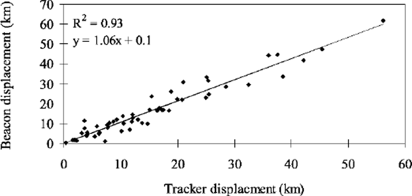
Fig. 2. Tracker vs beacon ice displacements, april-november 1998 regression results (10 beacons) are included.

Fig. 3. Tracker vs beacon ice-motion direction, april-november 1998. regression results (10 beacons) are included.
Noetix Research (unpublished information) found Tracker errors of < 1 km in magnitude when tracking ice conditions in Canada’s Gulf of St Lawrence and western Arctic regions. The Tracker errors in this current study are quite large in comparison to other demonstrations using ice-tracking algorithms, but these error differences are largely a function of the ice conditions in the NOW region. As new ice types in the polynya do not form coherent floes, they are difficult to track in the SAR time series, resulting in derived ice-drift rates which are significantly lower than the actual rates. The relatively high ice velocities found in Smith Sound may also contribute to the relatively large Tracker errors, as ice floes may be exported from the region prior to the subsequent RADARSAT-1 image acquisition. Although new ice types forming in the polynya cannot be tracked, older ice from the Arctic basin or new ice that has thickened dynamically as it drifts through the polynya can (Fig 1). This provides information on the velocity of ice moving through the polynya.
During the polynya season (spring), the weekly ice motion (weeks 13−26) in Smith Sound (Fig. 4) averaged 0.08 ms−1 (6.9 km d−1) to the west. This supports the latent-heat export theory, i.e. that winds and/or ocean currents play a significant role in removing ice from the region and maintaining the open-water area of the polynya. The import of ice back into Smith Sound along the Greenland coast is also evident in Figure 4. C.J. Mundy and D. G. Barber (unpublished information) speculated that medium-thick first-year ice (0.7 to >1.2m), which dominated the eastern margin of the polynya during spring 1998, emerges in southwestern Greenland due to "recycling" by winds and/or ocean currents in Baffin Bay. The role of sensible heat in forming and maintaining the NOW polynya was not evident in the ice-motion data. Areas of diminished velocities represented regions of fast ice, so sensible-heat mechanisms could not be conclusively determined using RADARSAT Tracker-derived ice-motion maps alone.

Fig. 4. Weekly-averaged ice motion ( weeks 13−26) for the smith sound region, spring 1998.
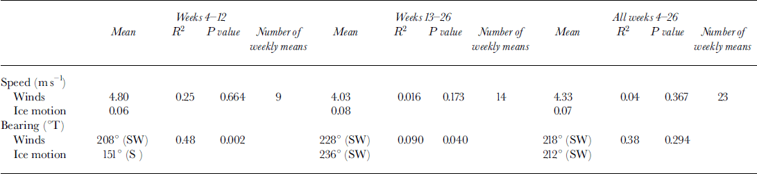
To understand more about the effects of latent-heat export, weekly-averaged ice-motion maps (weeks 4−26) were compared to weekly-averaged wind data (weeks 4−26) for the Smith Sound region (Figs 4 and 5). Noticeable similarities in direction are found when comparing these maps. A time-series analysis of the Smith Sound weekly ice motion vs weekly winds is presented in Figure 6. Coefficients of determination were then calculated to determine the influence of winds on ice motion in Smith Sound (Table 1). In Smith Sound, the influence of wind speed on ice drift is minimal for all weeks studied (R2 = 0.04), and also before (R2 = 0.25) and after the ice bridge (R2 = 0.016). Prior to ice-bridge formation, ice concentrations begin to increase as ice becomes congested in the narrow channel between Ellesmere Island and Greenland. This causes ice speeds to slowly decrease until the formation of the ice bridge. After the formation of the ice bridge, ice concentrations decrease and the open-water/thin-ice area within the polynya increases, allowing the ice motion in Smith Sound to increase. These higher ice-motion speeds do not always correlate well with areas of high wind speeds (see, e.g., week 23, Fig. 6). The Smith Sound bearing coefficient of determination for wind and ice motion prior to the ice-bridge formation is R2 = 0.48, after is R2 = 0.09 and for all weeks is R2 = 0.38. The regression results indicate that before the ice-bridge formation almost 50% of the variation in ice motion could be accounted for by winds, while after the ice-bridge formation the influence of winds was insignificant. Poor regression results are attributable to the fact that ice velocities are greater in regions of low ice concentration, and do not necessarily compare to areas with high wind velocities (Figs 4 and 5). It can also be seen from the time series (Fig. 6) that after the formation of the ice bridge in week 12, there is a trend toward higher ice velocities (e.g. by week 26) which is not mirrored in the wind velocities. The influence of winds may also explain the recycling of ice back into Smith Sound along the Greenland coast found by C.J. Mundy and D. G. Barber (unpublished information). It is apparent from Figures 4 and 5 that ice import into Smith Sound is also influenced by wind direction at the weekly time-scale.

Fig. 5. Weekly-averaged winds (weeks 13−26) for the smith sound region, spring 1998.

Fig. 6. Time series of (a) weekly-averaged ice and (b) wind speeds (ms−1) with bearings (true) for the smith sound region for weeks 4−26, 1998. see directional arrows underneath each graph.
Table 1. Smith sound ice-motion and wind-regression results (weeks 4−26,1998)
During the winter, cold polar air masses cover the Arctic, causing low-pressure systems to dominate. This polar front prevents storms in Davis Strait and Labrador from entering the Arctic (Reference Barry, Bradley, Jacobs, Weller and BowlingBarry and others, 1975). Solar radiation increases in the spring period, reducing the effects of this Arctic low-pressure system and allowing warm westerlies to move into the higher latitudes. This seasonal shift is evident in the spring-time weekly winds and ice-motion time series (Fig. 6). The ice motion is predominantly to the south until week 18, when it changes to the west. This change may be due to the northward retreat of the Arctic atmospheric front in the spring, allowing storms from the Labrador and Davis Straits into the region (Reference Barry, Bradley, Jacobs, Weller and BowlingBarry and others, 1975). Reference Ito and MüllerIto and Muller (1977) also speculated that during the spring of 1974−76 an increase in storms with northerly winds might have weakened the ice bridge. Ice motion and wind directions to the north increased towards the end of june 1998 as the ice bridge started to break up (Fig. 6), which supports Ito and Muller’s observations.
Conclusions
RADARSAT-derived Tracker ice-motion maps are a useful and accurate tool for monitoring ice motion in the NOW region, with the ice-motion vectors comparing well with in situ beacon measurements. Analysis of the regional ice-motion fields in Smith Sound during spring 1998 shows that ice export is a dominant process in maintaining the polynya region. This supports the theory that latent-heat export may play a more important role in polynya formation and maintenance than previously stipulated (Reference Smith, Muench and PeaseSmith and others, 1990), although no oceanographic data were available during the current study to determine the magnitude of sensible-heat input. This case-study also shows that the export of ice from the Smith Sound region in spring is influenced by wind direction, with the relationship between wind velocity and ice-export rate depending on the regional ice concentration. A seasonal change in the large-scale sea-ice motion with winds is evident in the time series, and is attributed to changes in the synoptic atmospheric circulation pattern. The frequency of northward ice motion increased in June 1998 as winds to the north contributed to the disintegration of the ice bridge blocking northern Smith Sound, as found by Reference Ito and MüllerIto and Muller (1977).
A further analysis of ice motion for other regions of the NOW polynya and during other seasons in 1998 will validate these conclusions further. Future work will test the effects of wind velocity on ice motion by incorporating the 1998 NOW ice types and concentrations derived from RADARSAT-1 data (C.J. Mundy and D. G. Barber, unpublished information) into this analysis. Oceanographic data from the concurrent NOW cruises (1997−99), which are not yet available, should provide further insight into the relative role of sensible heat in the formation and maintenance of the NOW polynya.
Acknowledgements
The authors would like to thank the following for their support and contributions to this study. The ice-beacon data were provided by the U.S. National Ice Center (Washington, DC), the Canadian Ice Service, Bedford Institute of Oceanography, McGill University and St John’s College at the University of British Columbia. Field support was provided by the CIS, the University of Manitoba NOW grant provided by the Natural Sciences and Engineering Research Council, the Canadian Coast Guard, the Polar Continental Shelf Project and through a grant from the Canadian Northern Studies Training Program. D. Patterson of Carleton University Geography Department wrote the Arcview Geographic Information System scripts needed to create the monthly ice-motion maps, and J. Heinrichs from Fort Hays University (Kansas) Department of Geoscience interpolated the NOW meteorological datasets. We thank two anonymous reviewers for their helpful comments.


