

In this chapter, I demonstrate that patterns of international trade, whether prehistoric or historic, can only be understood at multiple scales, running from the local to the global (cf. Parkinson and Galaty Reference Parkinson, Galaty, Parkinson and Galaty2009). I apply the term “glocal” to those decision-making processes that operated microregionally and over the short term but were linked to, and therefore affected and were affected by, pan-regional systems of geopolitical and economic interaction. My primary assertion is that, while all politics are indeed local (Schon Reference Schon, Parkinson and Galaty2009), the degree to which individual and state agents acknowledged and sought to balance local and global strategic concerns varied in response to systems of political economy. Political economies likewise varied from state to state; they were structured and functioned differently and were products of different regional historical trajectories.
Considering local, agentive needs and wants is thus vitally important when addressing world-systemic processes, like international trade, as has been generally recognized in recent years by world-systems analysts (see review in Galaty Reference Galaty2011; see also Hall et al. Reference Hall, Kardulias and Chase-Dunn2011). At the same time and as a result, notions of dependency that were central to world-systems theory as originally formulated have been rethought, transcending the core-periphery dichotomy and opening up ample space for much more complicated world-systemic relationships (see, e.g., Hall’s [2001] models of complex incorporation). Kardulias (Reference Kardulias2007) has suggested, for instance, using the North American and Cypriot frontiers as examples, that peripheral societies often set the conditions for their own incorporation into larger states and empires, a process he calls “negotiated peripherality,” which privilege local agency, while situating agentive behaviors within larger global frameworks (e.g., Galaty et al. Reference Galaty, Lafe, Lee and Tafilica2013).
With the preceding in mind, the Late Bronze Age Mycenaean koine (ca. 1650–1200 BC) is used as a case study for addressing “glocal” behaviors in prehistoric contexts (Figures 6.1 and 6.2; Table 6.1). Different Mycenaean states, namely Mycenae and Pylos, experienced different degrees of integration into the Eastern Mediterranean Bronze Age world system: (1) because they were quite different in terms of geography and history, but also, and more importantly, (2) because individuals in those states, elite and nonelite alike, operated within very different political-economic systems. Glocal concerns were different in Mycenae than they were in Pylos because local political-economic conditions were different. These conclusions seem like simple, straightforward ones, and to some extent they are, but Mycenaean Greece has traditionally been depicted as a single, unified economic and sociopolitical entity (e.g., Eder and Jung Reference Eder, Jung, Weilhartner and Ruppenstein2015; Kelder Reference Kelder2010) when in reality it was not. Differences between Mycenaean states are typically ignored or elided and local agentive behaviors homogenized, subsumed by the hegemonic activities of palatial authorities, as recorded in Linear B. This approach to the Mycenaean states specifically, and to ancient states in general, no longer works (cf. Galaty, Nakassis, and Parkinson Reference Galaty, Nakassis and Parkinson2011; Nakassis, Galaty, and Parkinson Reference Nakassis, Galaty and Parkinson2016; Parkinson, Nakassis, and Galaty Reference Parkinson, Nakassis and Galaty2013). This chapter and this book may therefore serve as a corrective.
6.1. Map of Greece showing the main sites and regions discussed in the text. Rebecca Seifried, University of Illinois, Chicago.
6.2. Study region boundaries, the Argolid and Messenia, showing known and probable palatial centers. Rebecca Seifried, University of Illinois, Chicago.
Table 6.1 Chronology of Greece and the Adriatic
| Cretea | Mainland Greecea | |
|---|---|---|
| Minoan | Helladic | |
| Late Bronze III | 1390–1070 BC (Mycenaean) | 1390–1070 BC (developed palaces) |
| Late Bronze I-II | 1600–1390 BC (Neopalatial) | 1600–1390 BC |
| Middle | 2100–1600 BC (Protopalatial) | 2000–1600 BC |
| Early | 3100–2100 BC (Prepalatial) | 3100–2000 BC |
| Neolithic | ca. 6800–3100 BC | ca. 7000–3100 BC |
| Eastern Adriatic and Western Balkansb | ||
| Late Bronze Age | ca. 1300–700 BC | |
| Middle Bronze Age | ca. 1600–1300 BC | |
| Early Bronze Age | ca. 2400/2200–1600 BC | |
| Chalcolithic | ca. 3500–2400/2200 BC |
a Tartaron Reference Tartaron2008
b Dimitrijević, Težak-Gregl, and Majnarić-Pandžić Reference Dimitrijević, Težak-Gregl and Majnarić-Pandžić1998
In fact, comparative analysis indicates much intra- and interregional variation within and between the Mycenaean states, which were, contrary to assertions otherwise, quite different from one another. This variation stems from multiple sources and conditioned how Mycenaean people and institutions interacted with people and institutions in nearby peripheral and marginal zones, such as those in Italy and up the eastern Adriatic coast. My analysis indicates that Mycenae and Pylos filled very different roles in the Late Bronze Age Mediterranean world system not only because they experienced different geographies and histories, but more precisely because those geographies and histories engendered radically different political economies. Moreover, because the inhabitants of the Pylian state possessed glocal concerns that were oriented west more often than east (Galaty, Tomas, and Parkinson Reference Galaty, Pullen, Parkinson, Seifried, Touchais, Laffineur and Rougemont2014), they probably did not serve as nodes in exchange systems that, according to Kristiansen and Larsson (Reference Kristiansen and Larsson2005), connected the Near East to continental Europe; rather, those connections were forged by Mycenae and likely took a more northerly route.
Sources of Variation
Geography
The whole of Greece is often characterized as mountainous and difficult to traverse, but equally accessible by sea from all directions, and relatively dry, but similarly affected by a predictable Mediterranean weather pattern. These blanket characterizations mask much regional variation in topography and climate, however. There are marked geographical differences across Greece, between north and south for example, that would have strongly affected economic activities and organization, as well as lines of communication and cultural interaction. Likewise, Greece is often depicted as being resource poor, which may be true in relative terms, but again, masks differences. Different Mycenaean states had different kinds of raw materials at their disposal. Furthermore, different regions possessed, in varying amounts and degrees of quality, access to various basic resources, such as soil and water. Thus, what was produced and traded, and whether and how regional resources were controlled by Mycenaean elites, varied from state to state, in part as a function of geographical differences. These differences affected processes of state formation in Greece, beginning as early as the Early Bronze Age (ca. 3100 BC), if not earlier.
History
Different Mycenaean states followed different paths to complexity and experienced different developmental histories. While Mycenaean states shared common roots in the preceding Middle and early Late Bronze Age (Voutsaki Reference Voutsaki and Pullen2010; Wright Reference Wright and Rehak1995), and Mycenaean people shared a common Greek language and perhaps “ethnicity” (Davis and Bennet Reference Davis, Bennet and Laffineur1999), there is also evidence for increasing heterogeneity and regionalization over time (Wright Reference Wright, Alcock and Cherry2004). Mycenaean individuals living in different Mycenaean states accessed very different landscapes, but also pursued different social goals, in different social arenas. There were, for example, differences in ritual and burial practice from one Mycenaean state to another (Voutsaki Reference Voutsaki and Branigan1998). Variation in social behavior is also linked to differences in patterns of consumption, for example of prestige goods, including trade goods (Schon Reference Schon, Parkinson and Galaty2009). Differences in regional developmental trajectories – and in social organization – are thus, to some degree, the direct result of different Mycenaean people living in different Mycenaean states emphasizing different ways of interacting with each other and with the wider Mediterranean world system.
Boundaries
It is now clear that the boundaries that separated Mycenaean polities from their nearest neighbors, in the Balkans and Cycladic Islands for instance, were real, but permeable. They were zones of cultural interaction and transfer, similar to modern frontiers (Feuer Reference Feuer2011). And yet, different Mycenaean states clearly preferred different international trade partners and experienced shifting levels of interaction intensity through time (Cline Reference Cline, Galaty and Parkinson2007). Boundaries opened and closed in response to numerous internal and external factors. Changes occurring at one end of the Mediterranean interaction sphere might precipitate changes at the other end. Archaeologically identifiable shifts in Mycenaean trade may signal developments in the wider Bronze Age Mediterranean world system, to which Mycenaean people and institutions responded.
For example, the amount and nature of trade between the Aegean and Egypt changed from one dynasty to another and during the intermediate periods (Galaty et al. Reference Galaty, Parkinson, Cherry, Cline, Kardulias, Schon, Parkinson and Galaty2009). During phases of Egyptian political and economic decentralization, trade with the Aegean, though less formalized, may have increased, and Egyptian trade goods may have become more widely available, not less, thereby altering local systems of political economy. Likewise, at the close of the Mycenaean age, when access to eastern sources of bronze diminished, contacts between sub-Mycenaean peoples and their Adriatic neighbors increased, as individuals searched for alternate sources of metal ore.
Agency
While variable geography, historical inertia, and shifting boundaries all had roles to play in determining Mycenaean sociopolitical organization and trade contacts, decisions made by local actors were equally, if not more, important. We can describe this decision-making process as “glocal” (Maran Reference Maran, Wilkinson, Sherratt and Bennet2011): Personal choices made by individuals at all levels of society shaped processes of Mycenaean interaction with the external world. And because the “palatial” period – the Late Helladic IIIB (ca. 1300–1200 BC) – spanned only a few generations at most, intergenerational and short-term intragenerational behaviors strongly conditioned the strength of and reasons for international trade. Consequently, to understand the roles played by long-distance trade in Mycenaean society, and in any society, the goals of local agents must also be understood. This endeavor is, of course, made easier through access to the Mycenaean Linear B records, bearing in mind, though, that the majority of these were found at a single Mycenaean center, that of Pylos.
Mycenaean States Compared
The geography of Greece appears to have influenced where and how the various Mycenaean states formed. Despite complex proto-urban polities on several Aegean islands – for example, on Akrotiri, Melos, and Kea – palatial states did not form there. It may be that the Greek islands were too small or dry to support the kinds of networked, territorial behaviors, based on systems of direct taxation, which characterized Mycenaean states. Additionally, it is equally possible, in fact likely, that island cultural values mitigated against overly hierarchical social systems and institutions. States did form on Crete, a much larger island, but the corporate, Minoan peer polities appeared earlier and were quite unlike the Mycenaean states. They also had earlier, more direct contact with the Near Eastern and Egyptian core states. Even after the Mycenaean conquest of Knossos and the destruction of all other palaces, Minoans maintained a distinct language, culture, and ethnic identity (Driessen and Langohr Reference Driessen, Langohr, Galaty and Parkinson2007). With the exception of Mycenaean Knossos, Mycenaean states are found only in southeast Greece, south of a line drawn between Thessaly and Messenia. The differences between north and south Greece – the so-called north-south divide – were first investigated by Halstead (Reference Halstead, Mathers and Stoddart1994) with reference to the Neolithic. In north Greece, where there was more rainfall, long-lived “tell” settlements formed, based on arable agriculture. In south Greece, relatively short-lived flat and cave settlements formed, based on dry farming and pastoralism. Renfrew’s (Reference Renfrew1972) “Mediterranean triad” is a southern Greek phenomenon. These differences persisted into the Bronze Age and may help explain why Mycenaean states formed where they did: in the south, counterintuitively. The risks associated with farming in southern Greece led Halstead and O’Shea (Reference Halstead, O’Shea, Renfrew and Shennan1982) to propose a “social storage” model for the rise of states there, and not elsewhere, in Europe.
While climate helps explain Mycenaean settlement patterns, it seems likely that secondary processes of contact also influenced state formation and organization (Parkinson and Galaty Reference Parkinson and Galaty2007). The Mycenaean states form a parabolic arc that collected and reflected first Minoan and later Eastern Mediterranean influences. Their orientation was directed to the southeast, toward Crete and the Eastern Mediterranean. This is no accident. Each Mycenaean state was positioned to control trade moving south to north, at first with Crete as an intermediary, and later through direct interaction with other Mediterranean powers (“brother to brother” as it were). The Argolid states controlled overland access from the Argolic and Saronic gulfs to the Corinthian gulf. Pylos in Messenia controlled trade moving from the Aegean to the Adriatic. Again, however, while geography matters, local social concerns operating in each Mycenaean state over time also influenced the impetus for and nature of international trade contacts. For example, by the Late Helladic III, Mycenaean-style pottery is found at sites throughout the Eastern Mediterranean, sometimes in large numbers, but chemical characterization indicates that it is almost exclusively from the Argolid, probably made at Mycenae (most recently, Tomlinson Reference Tomlinson, French and Tomlinson2013). On the contrary, pottery from Pylos is never (or very rarely) found outside of Messenia. Likewise, Mycenae’s perfume was produced for an international market, while Messenia’s perfume was consumed locally, used primarily in religious contexts (Bendall Reference Bendall2007). Thus, whereas the Argolid states, Mycenae in particular, were plugged directly into Eastern Mediterranean markets, Messenia appears to have been out of the loop and inward looking, or invested in different loops elsewhere.
While foreign imports to any of the Mycenaean states never occurred in very large quantities, particularly when converted from absolute numbers into “contacts” (Parkinson Reference Parkinson and Pullen2010), Mycenae clearly took the lion’s share during LH IIIA-B (beginning ca. 1415 BC). However, contrary to popular belief, evidence for international trade with Greece increases slightly following the collapse, though it is no longer channeled through the Mycenaean states. The vast majority of foreign goods are found in sub-Mycenaean graves. Unlike the Argolid, where settlement occupation continues into the Iron Age, Pylos was almost completely abandoned after the collapse. There are geographic reasons for the variable effects of the collapse, but more meaningfully, differences in local systems of political economy determined not only how the different Mycenaean states engaged the wider world system, but also what happened to them when that system destabilized. This approach has profound implications for our understanding of the European Bronze Age and the timing and direction of the spread of state-level institutions into Europe, as described by Kristiansen and Larsson (Reference Kristiansen and Larsson2005).
The Argolid and Messenia
While all the Mycenaean regions differed, one from the other, to some degree, this is particularly true of the Argolid and Messenia, the two regions about which the most is known (Figure 6.1).1 For example, during the Late Helladic IIIB the Argolid supported several primary centers – Mycenae, Tiryns, and Midea at least – while Messenia supported only one – Pylos. As described previously, the Argolid tapped into widespread Mediterranean trade routes, while Messenia did not. The marked differences between the Argolid and Messenia have their basis in geography, but also result from differences in political-economic trajectory and organization.
Slope
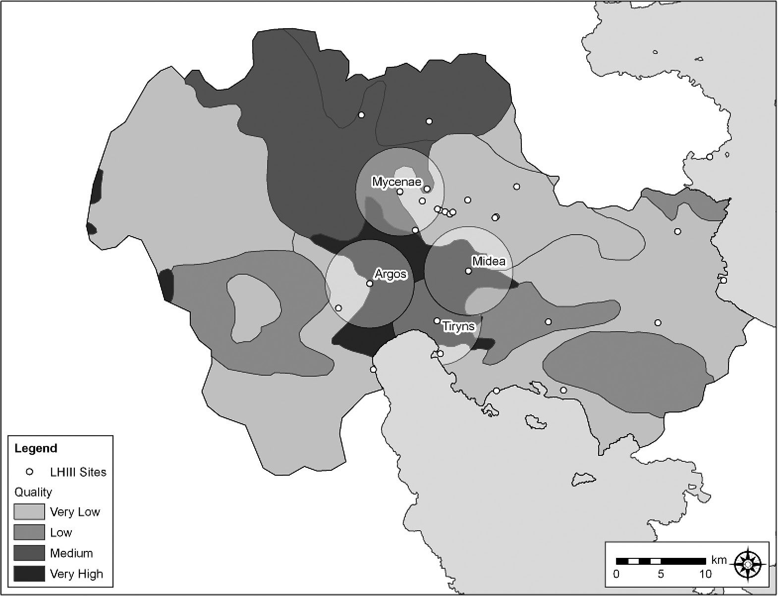
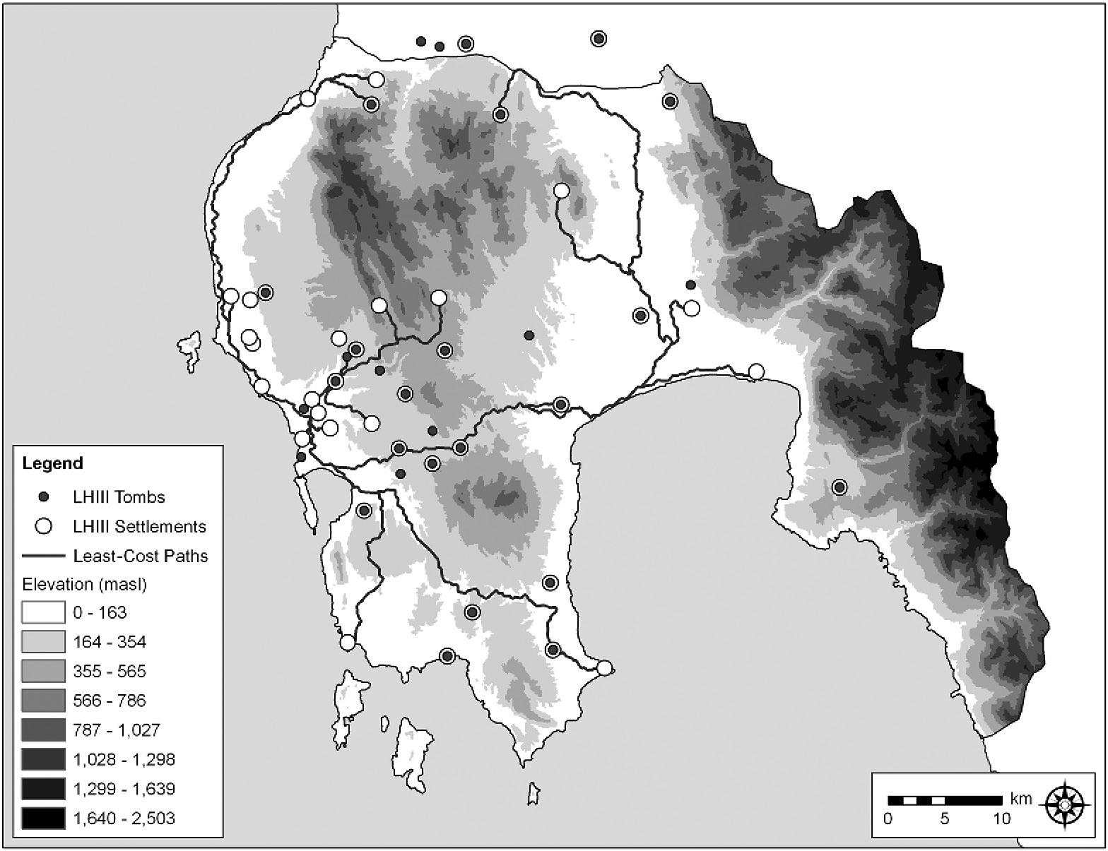
Whereas the mean slope in both regions is similar – 12.25 percent in the Argolid versus 11.28 percent in Messenia – the Argolid is dominated by a single expanse of flat land, the Argive plain (Figures 6.3 and 6.4).2 The slope curve for Messenia is smoother; areas of flat land are more widely distributed. But, like the Argolid, a single plain, drained by the Pamisos River, still encompasses much of the flattest land, and it is located in the Further Province, on the other side of the Aegalion range from Pylos. When slope is calculated for each settlement within 5-km radius circular catchments, it is clear that many of the largest, most important Argive sites – with the meaningful exception of Mycenae – had access to large tracts of flat land. In contrast, the largest, most important sites in Messenia, including Pylos, had access to much less flat land. The key exception is Thouria, in the Further Province. Its catchment encompassed 26 percent more land under a 4 percent slope than did Pylos, and Pylos’s catchment overlapped with that of many different, competing settlements. These data help to explain why, having incorporated the Hither Province’s secondary centers, Pylos had to expand into the Further Province. At the most basic level, the landscape of the Argolid is very different from that of Messenia, as is its geography. These differences strongly conditioned the shape and configuration of the political economies that developed in both regions by 1300 BC.
6.3. Slope analysis for the Argolid, showing 5-km radius catchments for Mycenae, Tiryns, Midea, and Argos. Rebecca Seifried, University of Illinois, Chicago.
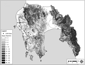
6.4. Slope analysis for Messenia, showing 5-km radius catchments for Pylos and Thouria. Rebecca Seifried, University of Illinois, Chicago.
Soil
Because flat land is not necessarily comprised of the best soils, Mycenaean capital availability can be operationalized by testing access to agriculturally productive soils, using the land classes developed and mapped by Yassoglou (Reference Yassoglou2004). In the Argolid, the primary centers had access to large tracts of good soils, particularly calcaric fluvisols, which are of the very highest agricultural quality (Figure 6.5). In contrast, Messenia possesses few soils of the very highest quality, and most of these are in the Further Province (Figure 6.6). When it comes to the Argolid, once again Mycenae is exceptional compared to other centers; it had access to far less good soil (Table 6.2). In Messenia, Pylos had no highest quality soil within its catchment, and it would have had some difficulty raising the staple surpluses needed to underwrite its economy. Because of this, an expansion into the Further Province seems logical, if not inevitable.
6.5. Soil classes, Argolid, showing 5-km radius catchments for Mycenae, Tiryns, Midea, and Argos. Rebecca Seifried, University of Illinois, Chicago.
6.6. Soil classes, Messenia, showing 5-km radius catchments for Pylos and Thouria. Rebecca Seifried, University of Illinois, Chicago.
Table 6.2 Soil Classes by Catchment for Mycenae, Tiryns, Midea, Argos, Pylos, and Thouria
| Name | Percent | Soil Type | Quality | Desertification | Uses |
|---|---|---|---|---|---|
| Mycenae | 32.92 | Calcaric Leptosol | Very low | Very high | Wild nature |
| Mycenae | 11.46 | Calcaric Fluvisol | Very high | Low | Agriculture |
| Mycenae | 55.62 | Vertic-Calcic Fluvisol | Medium | Medium | Forest, controlled pasture |
| Midea | 1.40 | Calceric Leptosol | Very low | Very high | Wild nature |
| Midea | 25.16 | Calcaric Leptosol | Very low | Very high | Wild nature |
| Midea | 13.45 | Eutric Leptosol | Low | High | Forest, controlled pasture |
| Midea | 60.00 | Calcaric Fluvisol | Very high | Low | Agriculture |
| Tiryns | 10.03 | Calceric Leptosol | Very low | Very high | Wild nature |
| Tiryns | 6.74 | Eutric Leptosol | Low | High | Forest, controlled pasture |
| Tiryns | 83.23 | Calcaric Fluvisol | Very high | Low | Agriculture |
| Argos | 31.47 | Calceric Leptosol | Very low | Very high | Wild nature |
| Argos | 0.88 | Calcaric Leptosol | Low | Very high | Forest, controlled pasture |
| Argos | 67.65 | Calcaric Fluvisol | Very high | Low | Agriculture |
| Ano Englianos | 13.72 | Eutric Regosol | Low | High | Forest, controlled pasture |
| Ano Englianos | 86.28 | Calcaric Cambisol | High | Medium | Forest, controlled pasture and agriculture |
| Thouria | 18.01 | Calcaric Leptosol | Low | Very high | Forest, controlled pasture |
| Thouria | 44.11 | Calcaric Regosol | Medium | Medium | Forest, controlled pasture and agriculture |
| Thouria | 37.88 | Calcaric Fluvisol | Very high | Low | Agriculture |
Given the distribution of slope and good soils in both regions, we might expect that people would have settled near the best land. However, a nearest neighbor analysis indicated no statistically significant degree of settlement clustering. Centrifugal forces other than access to good land appear to have pulled the settlement system apart in both the Argolid and Messenia, as Mycenae and Pylos demonstrate. These forces were social, and political economic, but were structured differently in both regions, and were variously affected by differences in how Mycenae and Pylos accessed the Mediterranean world system.
Travel Times
To compare the structure of Mycenaean intra- and interregional interaction spheres, and their integration into wider Mediterranean systems, the distance and travel times – both over land and by sea – between the various palatial centers and between each palatial center and Crete were calculated using Google Earth (Table 6.3). The data, while necessarily rough, are nevertheless highly informative. Predictably, the most distant palatial center, and the least central, is Iolkos in Thessaly. The next least connected center is Pylos. As it turns out, Mycenae is the most connected, which may help to explain its particular location in the Argolid region, far from the nearest port yet midway between the Argolic, Saronic, and Corinthian gulfs. When sailing distances and times are calculated, however, these differences largely disappear, although the Argive sites were slightly closer by sea to both Chania and Knossos on Crete.3 Mycenae had more direct access to Crete and to Eastern Mediterranean trade routes, but, more importantly, it was better connected to all other palatial centers than was Pylos.
Table 6.3 Travel Times in Days over Land and by Sea from Each Palatial Center to Every Other Palatial Center
| Site Name | Walking | Port Name | Sailing |
|---|---|---|---|
| Pylos | 7.74 | Pylos | 2.91 |
| Thebes | 5.18 | Aliki | 4.38 |
| Orchomenos | 6.11 | Antikyra | 4.21 |
| Gla | 6.42 | Gytheio | 2.55 |
| Menelaion | 6.04 | Nafplio | 2.85 |
| Ayios Vasilios | 6.26 | Korphos-Kalamianos | 2.85 |
| Mycenae | 4.29 | Piraeus | 2.68 |
| Tiryns | 4.59 | Mitrou | 4.15 |
| Argos | 4.47 | Volos | 3.96 |
| Midea | 4.50 | ||
| Athens | 5.34 | ||
| Iolkos | 11.51 |
Least-Cost Paths
As a result of these various differences in local and regional geography, political economies were deployed differently in Messenia than they were in the Argolid. To study local, political-economic interactions, least-cost paths based on slope were mapped from each large center in the Argolid and Messenia to Mycenae and Pylos, respectively (Figures 6.7 and 6.8). This allows identification of the most cost-efficient routes – in terms of energy – for traveling between the settlements in each region. As expected, both path systems take advantage of flat land. However, while the system in the Argolid is dendritic, that of Messenia is circulatory, a pattern first identified by Lukerman (Reference Lukerman, McDonald and Rapp1972) forty years ago. There are only a few ways of traveling to Pylos, and none of them is very direct. Secondary centers like Nichoria, Koukounara, Ordines, and Romanou/Beylerbey were key nodes in the system, perfectly positioned to intercept people, things, and information. Unlike Pylos in Messenia, in the Argolid most roads led directly to Mycenae. There were no intermediary, secondary nodes, which illustrates the relative independence of the Argive palatial centers. Messenia’s system of transportation and communication was made to serve the political-economic needs of the palace – a point reinforced by an analysis of the sacred landscape.
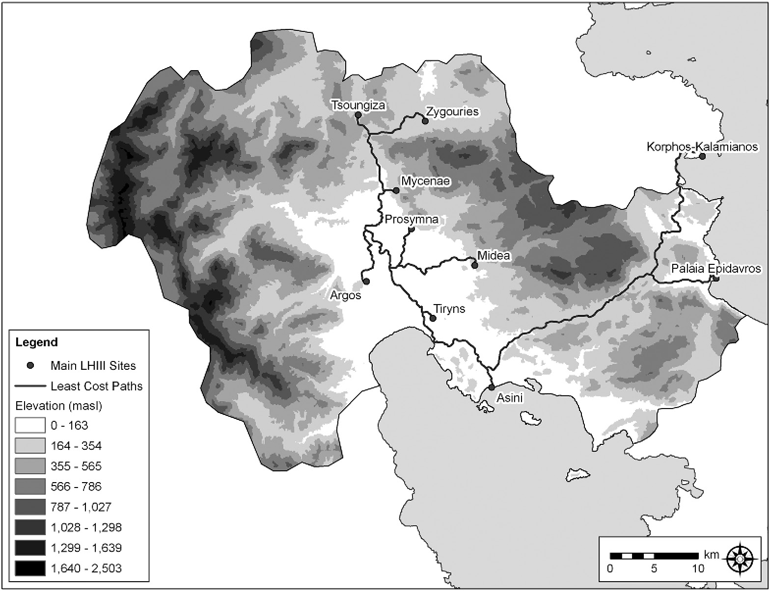
6.7. Least-cost path analysis: Argolid. Rebecca Seifried, University of Illinois, Chicago.
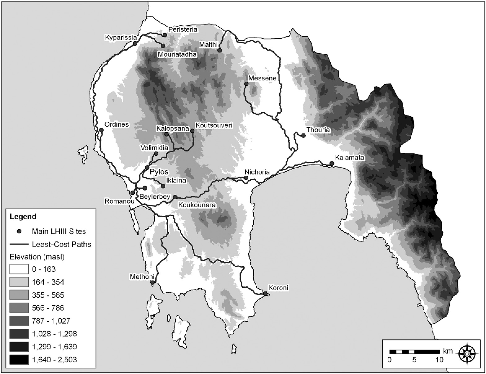
6.8. Least-cost path analysis: Messenia. Rebecca Seifried, University of Illinois, Chicago.
Sacred Sites
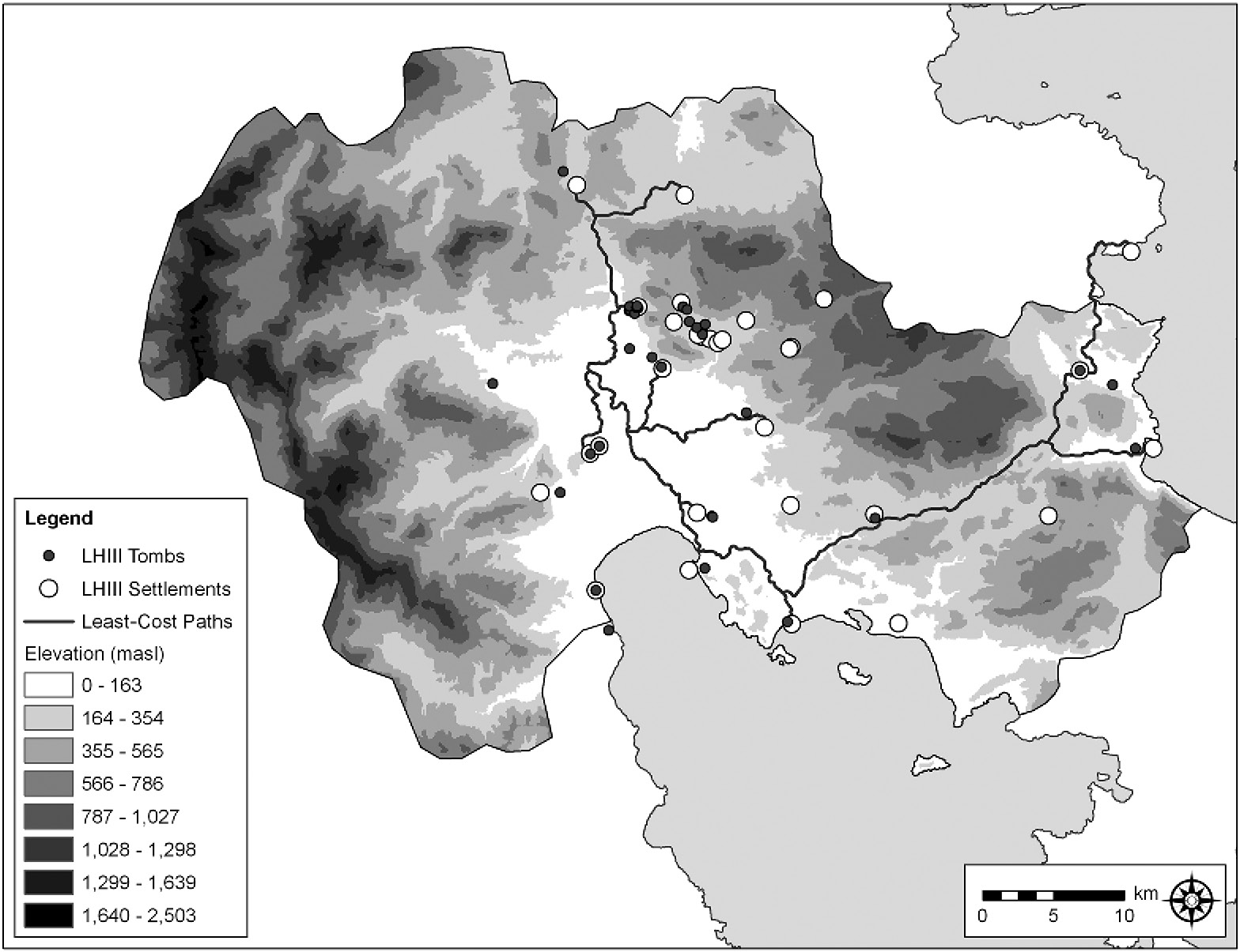
To study the Argive and Messenian sacred landscapes, the locations of chamber and tholos tombs were mapped and their distribution in relation to palatial centers and the cost path systems was analyzed (Figures 6.9 and 6.10). It can be assumed that tombs, especially tholoi, were symbols of power and sites of memory (see Bennet Reference Bennet, Neimeier and Laffineur1995). Conclusions mirror those reached by Voutsaki (Reference Voutsaki and Branigan1998) based on her comparative analysis of Argive and Messenian mortuary systems. As discussed by Voutsaki (Reference Voutsaki and Branigan1998), the Argolid has far fewer tholos tombs than Messenia, but those tend to be larger in size and located near palatial sites. Messenia’s tholos tombs are more numerous and much more dispersed. But, as discussed by Bennet (Reference Bennet, Galaty and Parkinson2007), most of these were no longer used by 1300 BC, and those still in use were associated almost exclusively with the palace. In Messenia, Pylos took a shared sacred landscape of tholoi and erased it. This transformation did not happen in the Argolid, where, again, secondary centers were independent palatial peers to Mycenae.
Political Economy
Several conclusions regarding Mycenaean political economy can be drawn from the preceding analyses. First and foremost, the Argolid and Messenia, as two Mycenaean regions among many, were indeed very different from one another. The history of Mycenaean Messenia was one of competition over land, which necessitated the incorporation of nearby secondary centers, like Iklaina, where several large buildings were destroyed in late LHIIIA and rebuilt in early LHIIIB along different architectural lines (Cosmopoulos Reference Cosmopoulos2006). However, as the catchment analysis demonstrates, incorporating secondary centers did not allow Pylos to access much more productive land. The real prize was instead the Further Province, taken at the start of the LH IIIB period. A similar process of expansion and incorporation did not happen in the Argolid, where many large sites, several of them palatial, shared a space that is small in area but replete with flat land and high-quality soil. Consequently, there were possibly as many as three distinct states in the Argolid by Mycenaean times. Why, then, did a similar process of state formation not occur in the Further Province of Messenia, where the geography of the Pamisos plain resembles that of the Argive? A comparison of Mycenaean interaction spheres helps to answer this question.
6.9. Tomb locations: Argolid. Rebecca Seifried, University of Illinois, Chicago.
6.10. Tomb locations: Messenia. Rebecca Seifried, University of Illinois, Chicago.
Pylos was poorly positioned to access Mycenaean and wider Mediterranean trade routes, especially when compared to the Argolid states and Mycenae in particular (Figures 6.1 and 6.2). Whereas Pylos and the other western Messenian sites took advantage of their access to Mediterranean – including Minoan – trade routes in Early Mycenaean times, by Late Helladic III they had other concerns, and so turned inward. This conclusion is further reinforced by the work of Murphy (Reference Murphy, Nakassis, Gulizio and James2013), who has found that the vast majority of exotics from Messenian tombs date to the Early Mycenaean period, not to the period of the palaces.
Because Pylos had incorporated sites throughout Messenia, control of transportation and communication networks was paramount. As the least-cost path analysis demonstrates, the geography of Messenia lent itself to such an effort, and various large, long-lived settlements, such as Nichoria and Koukounara, were perfectly positioned to control overland movement. Sites like these became important district capitals in the LH IIIB Pylian state. Messenia’s mortuary landscape had developed during a period of intense, widespread competition between sites, which lasted into the LH III. A similar period of competition had occurred in the Argolid, but as demonstrated by Voutsaki (Reference Voutsaki and Pullen2010), it had largely ended by the beginning of the LH, representing the shift from a “kinship”-based economy to a “palatial” economy. Given Messenia’s geography, this shift took longer to effect and was not without conflict and pain. The Messenian sacred landscape, as represented by widespread tholos tombs, reflects a similar kinship-based, more corporately organized economy. This political economy was replaced by a palatial one by the Late Helladic III, and a sacred landscape that graphically and powerfully represented the earlier order was effaced.
When the end came, both Pylos and Mycenae were destroyed, but for different reasons. Pylos had turned the geography of Messenia to its own purposes. In this regard, it was not at all different from states the world over, including modern ones. When Pylos fell, the whole system went with it. The polities of the Argolid were much more compartmentalized. Not surprisingly, Tiryns lived on even as Mycenae crumbled.
Mycenaean Glocalism
Having compared geographic and political-economic differences in both the Argolid and Messenia, it is now possible to assess their variable roles in the Mediterranean world system and as conduits for people, things, and ideas moving to and from Europe. Mycenaean states were second-generation, secondary products of contact between Greek chiefdoms and Minoan states, which accelerated during the late Middle and early Late Bronze Age (Parkinson and Galaty Reference Parkinson and Galaty2007). Whereas the Minoan states can be characterized as corporate and heterarchical, the Mycenaean states were strongly networked and exclusionary (Blanton et al. Reference Blanton, Feinman, Kowalewski and Peregrine1996). And yet, there are apparent differences in terms of how each Mycenaean state was formed and organized. These differences stem in part from geography, as described in the preceding text, but also from variable experiences of contact with the Minoan states and the wider Mediterranean world system.
Recently, models of Mycenaean political economy have been reconceived and revised. Mycenaean elites are no longer thought to have operated redistributive, command-and-control economies (Galaty et al. Reference Galaty2011); rather, as documented in Linear B, they appear to have focused narrowly on mobilization of the raw materials and the labor forces necessary to support the production of various kinds of prestige goods. They did not administer regional economies per se, and much economic activity took place outside the purview of the palace. In fact, artifact distributions in Mycenaean settlements are best explained when a model of regional market exchange is applied (Parkinson et al. Reference Parkinson, Nakassis and Galaty2013). Given that there was much room in Mycenaean political economies for local agentive action, to what extent did glocalized behaviors affect the entry of different Mycenaean states into Mediterranean systems of trade, through time? A brief look at pre- and Early Mycenaean burial customs is instructive in this regard.
Burial Customs
As demonstrated by analysis of the artifacts from the Shaft Graves, Mycenae appears to have been in close, early contact with the Cyclades (e.g., Kolonna on Aegina) and Crete, and, probably indirectly, with various Near Eastern (including Anatolian) and African states, as well as with Europe (as indicated by amber and gold). Likewise, Pylos was in close, early contact with Crete, perhaps through the Minoan colony on Kythera, as well as with the Near East and Africa, again indirectly. On the Greek mainland in the late Early and Middle Bronze Age, most individuals were buried in chamber tombs and cist graves with few grave goods. Beginning in the early Middle Bronze Age, tumulus burial became common, in particular in Elis and Messenia in western Greece (Muller Reference Muller1989). Tumuli occur in far fewer numbers in the Argolid, and elsewhere, and tend to be later (Middle Helladic II-III). It is difficult to avoid the conclusion that mound burial spread south into Greece along the Eastern Adriatic coast from Dalmatia via the Ionian Islands. Unlike tumuli, the earliest tholos tombs are found on the Mesara Plain of Crete and housed the remains of whole communities. The first tholoi on the Greek mainland were built in Messenia and, like those on Crete, generally held a (relatively) wide cross-section of the local population. Those in the Argolid held far fewer individuals and were concentrated at Mycenae. Thus, from the start, we can identify quite different burial customs in the Argolid versus Messenia, which stem primarily from different initial experiences of the evolving Mediterranean world system.
Elite individuals in the Middle to Late Bronze Age Argolid appear to have had direct access to Minoan prestige goods (and, perhaps, craftsmen), a market that Mycenae eventually cornered. Prestige goods were used in competitive fashion to distinguish “warrior chiefs” – who may have traveled to Crete – and their immediate family members, both in life and in death (Wright Reference Wright and Shelmerdine2008). It has been suggested that the key to Mycenae’s success was control of the gold trade, which began in the Carpathians (Davis Reference Davis1983) and passed through, or included, north Greece (Vavelidis and Andreou Reference Vavelidis and Andreou2008); more than 15 kg of gold was found in the Shaft Graves at Mycenae alone. Unlike the Argolid, Messenia sat at the tail end of an interaction sphere that formed in the Early Bronze Age and spanned the Adriatic. This interaction sphere is marked by the presence of Cetina-style pottery at sites throughout the Adriatic (and in smaller numbers in the Aegean) (Tomas Reference Tomas, Parkinson and Galaty2009), now including Messenia (Rambach Reference Rambach2011). Messenia also had contacts with Minoan Crete, but these contacts were mediated by the Kytheran colony and were therefore different than Mycenae’s; they lead to more “corporate” systems of political economy, at least at first. The people of Messenia adopted the tholos tomb and used it in ways that mimicked the Minoans for communal burial. The Early Mycenaean predecessor to the LH IIIB palace at Pylos, which is admittedly poorly known, also demonstrates Minoan architectural influences and may have included a central court (Englehardt and Nagle Reference Englehardt and Nagle2011). Messenia thus had Adriatic leanings and a different, perhaps less confrontational, relationship with Minoan Crete. Mycenae had Balkan connections and a direct, possibly adversarial, relationship with Minoan Crete. Unlike Mycenae, which had gold, it is unclear what Messenia had to offer the Minoans in the way of trade goods and raw materials. It may be that the Minoans sought to tap into the Adriatic interaction sphere, and Pylos was a gateway to this (relatively distant) trade zone, one that avoided Mycenae.
Wanax and Damos
The Mycenaean political economy was characterized by tension between the ruler, the “wanax” (wa-na-ka), and his subjects, represented by the “damos” (da-mo), perhaps a kind of provincial, or community, council. The wanax sat at the top of a strongly hierarchical social system. He appears to have had military and religious obligations, and held frequent feasts in a large building, a “palace,” at the center of which was a “megaron,” a throne room with a large central hearth. He and teams of scribe-administrators, who were also members of the upper class, ran a wealth-financed economy, based on the production and consumption of various prestige goods, including perfume, cloth, chariots, weapons, and jewelry. The industrial activities of the wanax were supported through a system of indirect, proportional taxation. In Messenia, administration officials based at Pylos collected a suite of six commodities from at least sixteen districts, through district capitals, as described in the Linear B documents. Oddly, international shipments of finished goods are never recorded in Linear B. Perhaps trade took place seasonally (i.e., during the sailing season) and the extant tablets are from the wrong season. Or, scribes did not record international transactions because they were handled by the wanax, by independent merchant elites, or both. Or, it may be that Pylos did not engage in substantial international trade during the LH IIIA-B. The opposite appears to have been true at Mycenae and Tiryns, where there is much evidence for international trade during LH IIIA-B, although, as with Pylos, none of it is recorded in Linear B.
As modeled in the preceding text, the expansion of the Pylian state was quite different from that of the Argolid states. By the Early Mycenaean period, there were several competing centers in Messenia. Eventually, Pylos conquered them all, those in both the Hither and the Further Province (Bennet Reference Bennet, Galaty and Parkinson2007). In the Argolid, as many as three state centers coexisted. It is not known what kind of relationship Mycenae, Tiryns, and Midea, the three certain palatial centers, had, but they appear to have been peers and rivals, each controlling a different chunk of the Argolid and surrounding territories. It may be that the different evolutionary trajectories that mark the Argolid and Messenia are partly the result of geography, but also reflect very different starting points and very different positions in and experiences of the surrounding world system. Messenia was more “corporate” than “networked” through the start of the Late Helladic, at which point Pylos took over, through force, and instituted exclusionary state tactics. By contrast, in the Argolid, no one center managed to conquer all the rest, and, from the beginning of state formation there, they all emphasized exclusionary strategies. This means that by the time of the collapse, the people of the Argolid had already experienced 400+ years of networked political economy. The people of Messenia experienced only 100 years under Pylian rule, and there are strong indications that the relationship between ruler and ruled, wanax and damos, was not untroubled (Lupack Reference Lupack2011). As described previously, the wanax needed access to land, necessary to produce foodstuffs to support palace staff, his religious obligations, and large state-sponsored feasts, as documented in Linear B. The various damoi, the local communities, appear to have held land communally, and (just like today) did not want to part with it or be overtaxed. In one Linear B tablet (Pylos Ep 704), the state adjudicates a dispute between a priestess named Eritha (e-ri-ta) and a damos, that of Sphagiānes (pa-ki-ja-ne). Eritha tried to claim a smaller landholding for herself (and therefore a lower tax obligation?) by arguing that some of her land was held by her for the damos.
Similar disputes may have occurred in the Argolid. If they did, they were not recorded in Linear B. Then again, far fewer tablets are extant from the Argolid states. It seems, though, that local people in Messenia had far different goals and concerns than did those in the Argolid. As a result, they engaged the outside world in ways that were different from the people of the Argolid. A brief, comparative look at pottery production and ports in the two regions helps make this point.
Pots and Ports
By the Late Helladic IIIB, most of the pottery in the Argolid appears to have been produced at Mycenae, much of it for export to the Eastern Mediterranean. In Messenia, some pottery may have been made at the palace, but there appears to have been at least three, possibly four, competing workshops in the region during the Late Helladic (Galaty Reference Galaty and Pullen2010). None of the pottery from Messenia was exported, at least to the Eastern Mediterranean. Pottery is one product amongst many in Messenia that was distributed through local exchange networks, and while mass-produced in at least one workshop – perhaps associated with the palace and run by a “royal” potter mentioned in Linear B – no one pottery workshop dominated the rest. Whereas pottery manufacture in the Argolid had been centralized for generations prior to collapse, first at Berbati, the valley to the east of Mycenae, and later at Mycenae, at the so-called Petsas House (Shelton Reference Shelton and Pullen2010), thus allowing an economy of scale that encouraged international trade, pottery manufacture in Messenia was relatively decentralized. The structure of the Messenian pottery industry reflects its deep regional roots and the relatively recent integration of the regional economy under Pylos, which did not or could not control pottery production fully. A similar pattern is reflected in the distribution of Melian obsidian in Messenia, all of which came into the state via the port site of Romanou (Parkinson Reference Parkinson and Pullen2010). Production and distribution of obsidian blades was not centralized at the palace. It was under the control of local craftsmen who operated outside the purview of the palace and must have engaged directly, and independently, with seafaring merchants.
The location and nature of Mycenaean ports further reflect differences in the organization of Mycenaean states. The main port in the Argolid must have been Tiryns, which was also a palatial center. It is hard to believe that Mycenae controlled Tiryns; nevertheless, access to the sea must have been through Tiryns, perhaps using independent merchants who operated out of the port. Another, intriguing possibility is that Mycenae tried to establish its own port town, as an alternative to Tiryns, at the newly discovered site of Korfos-Kalamianos on the western Saronic coast (Tartaron Reference Tartaron and Pullen2010). The Messenian port town at Romanou was not palatial, like Tiryns, and was subordinated to the palace at Pylos, perhaps as a district capital. This seems to have been the normal pattern in the Aegean, where inland palatial centers were typically paired with a nearby port. Only in the Argolid, however, did the main port constitute a palatial center in and of itself. For this reason alone, systems of trade and interaction must have been quite different in the Argolid as compared to Messenia.
Mycenaeans in the Adriatic
With the foregoing as background, it is now possible to discuss the differential effects of trade and the transmission of ideas from the Eastern Mediterranean through the Aegean and into Europe (cf. Kristiansen and Larsson Reference Kristiansen and Larsson2005: 153). What was transmitted and via which routes would have been affected strongly by timing – that is, when during the Bronze Age connections were established – and directionality – that is, through which Mycenaean state(s) connections were effected. Mycenaean links with the Adriatic may serve as a primary example.
As Schon (Reference Schon, Parkinson and Galaty2009) describes, the amount of foreign trade during the Early Mycenaean period (MH III-LH II) was exceedingly small; fewer than 50 objects and 20 contacts over the course of 300 years. Much of this trade, with the possible exception of amber, was likely funneled through Minoan Crete and Kolonna on Aegina, and was therefore indirect and down-the-line. There are few, almost no, examples of definite Early Mycenaean artifacts found outside of Greece, with the exception of small amounts of possibly Early Mycenaean pottery from Italy (Sgouritsa Reference Sgouritsa, Laffineur and Greco2005) and Syria-Palestine (Leonard Reference Leonard1994). The Early Mycenaean pottery in Italy is “enigmatic” and its precise origin is not known (Merkouri Reference Merkouri, Philippa-Touchais, Touchais, Voutsaki and Wright2010). Mycenaean-Italian connections, however, become more and more important through time, and are discussed in more detail in the following text. Early Mycenaean pottery in Syria-Palestine almost certainly arrived from the Argolid via Crete and does not demonstrate a direct, sustained connection between Greece and the Near East. As noted previously, and by Kristiansen and Larsson (Reference Kristiansen and Larsson2005: 211–212, and figure 96), the more interesting and, perhaps, meaningful link during this period was that forged with the Balkans. However, whereas Balkan-style artifacts arrive in Early Mycenaean Greece, Early Mycenaean artifacts do not appear in the Balkans. The primary influence appears to have been from north to south, not the other way around.
Foreign trade increased tremendously during the Late Helladic III, and the trade patterns are interesting. The Argolid states shifted their attention to the Eastern Mediterranean, having knocked Minoan Crete out of the picture. As noted previously, Messenia appears to have disengaged from this interaction sphere during LH III. Trade with Italy increased, to the point that some archaeologists speak of Mycenaean colonies there; however, many of the “Mycenaean” pots from Italy were imitations made using local clays (see, e.g., Buxeda et al. Reference Buxeda i Garrigós, Jones, Kilikoglou, Levi, Maniatis and Mitchell2003; Vagnetti 2000–Reference Vagnetti2001: 113); therefore, explaining the exact relationship between Mycenaean Greece and Italy is difficult. It is not known exactly where the imported Mycenaean pottery in Italy was made, and the archaeometric data are unclear (Jones et al. Reference Jones, Vagnetti, Levi, Williams, Jenkins and De Guio2002). The Italian pottery does not match the Argolid’s well-known Mycenae-Berbati group, and a source in Messenia cannot yet be ruled out (Sgouritsa Reference Sgouritsa, Laffineur and Greco2005). Moreover, much of the pottery tested is not diagnostic. That which can be dated tends to be from the LH IIIC period: that is, after the fall of the palaces. Very little Mycenaean pottery is found elsewhere in the Adriatic, with the exception of the Ionian Islands, where there are Mycenaean sites, and Northwest Greece. No certain Mycenaean pottery has been found along the Dalmatian coast (Tomas Reference Tomas, Parkinson and Galaty2009). What Mycenaean pottery there is from Albania tends to be LH IIIC and is found mostly in far southern Albania (Galaty and Lafe Reference Galaty, Lafe and Kourtessi-Phillipakis2008; Lafe and Galaty Reference Lafe, Galaty and Forenbaher2009). People living along the Albanian and Dalmatian coasts and inland during the Bronze Age appear to have been more interested in acquiring bronze weapons; therefore, it seems likely that Mycenaean contacts in the Adriatic, prior to 1200 BC, were focused on a search for alternative ore sources (Galaty Reference Galaty, Galanaki, Tomas, Galanakis and Laffineur2007). These trade missions may have been launched from bases in the Ionian Islands and Epirus and may have increased in frequency following the collapse (Sherratt Reference Sherratt, Maran and Stockhammer2012). The northernmost certain Mycenaean settlement, marked by a small tholos tomb, is that of Glykys Limin in north Epirus near Preveza, which Tartaron (Reference Tartaron2004) describes as a “port of trade” or “gateway” community.
There are two routes whereby the Mycenaeans may have accessed the Adriatic. One route ran from Messenia up the coast of western Greece. The other ran through the Gulf of Corinth. We may assume that the former was employed by Pylos and the latter by the Argolid states. Both passed by Mycenaean sites in the Ionian Islands, and traders may have sailed from them to Italy before crossing back over and moving up the Eastern Adriatic coast. An overland route via the northern Aegean is also possible, through Thessaly or Macedonia for example, and may have been accessed by Mycenaeans at Iolkos (Adrimi-Sismani Reference Adrimi-Sismani, Galaty and Parkinson2007).
Based on the preceding (very brief) review of Mycenaean contacts with the Adriatic, some tentative conclusions can be drawn. First, the evidence for any kind of foreign interaction during the Early Mycenaean period is scant at best. Eastern Mediterranean influences on Mycenaean Greece appear to have come indirectly via Crete as well as from the north, roundabout, by way of the Carpathians, perhaps associated with the gold trade. These influences were most strongly felt at Mycenae. Second, by LH III the various Mycenaean states, with the exception of Pylos, were mostly engaged in Eastern Mediterranean trade. The Cyclades, Crete, the Dodecanese, and SW Anatolia were brought under strong Mycenaean influence, if not outright control, and Mycenaean states were in close contact with Cyprus, Syria-Palestine, and Egypt, as demonstrated by the Uluburun wreck. Contact with the Balkans waned, although there are numerous reports of Mycenaean pottery in Macedonia and Thrace, including FYROM and Bulgaria. It is not known which Mycenaean state forged the initial Italian connections, but it may have been Pylos, operating through the Ionian Islands (cf. Sgouritsa Reference Sgouritsa, Laffineur and Greco2005). Third, most of the nonimitation Mycenaean pottery from the Adriatic appears to be LH IIIC. If Pylos forged the initial contacts with Italy and the Adriatic, these were eventually co-opted by Mycenaean elites in the Ionian Islands. Ionian Mycenaean settlements grew following the collapse, perhaps due to an influx of refugees. It may be that these refugees came from Messenia, which was almost completely depopulated after 1200 BC.
The upshot of all of these developments is that if Eastern Mediterranean institutions spread into Europe via a southern “Mycenaean” route, as proposed by Kristiansen and Larsson (Reference Kristiansen and Larsson2005), it may have been far less important than the earlier, northern, steppe route. Any such spread may not have come via Mycenae and the other Argolid states, but, rather, may have been routed through Pylos and the Adriatic, primarily through Italy. This would explain the large amount of “handmade burnished ware” at Pylos, which may have an Italian/Adriatic origin, as well as at the port of Kommos in Crete (Rutter Reference Rutter, Maran and Stockhammer2012: 82–85). If Pylos was a conduit for secondary-state influences in Europe, then a very particular kind of Mycenaean political economy would have been propagated, one quite different from that of the Argolid, and one colored by very specific local Messenian needs and wants.
Conclusion
To conclude, each Mycenaean state was very different from the other, and Pylos in particular was quite different from Mycenae and the other Argolid states. These differences have a geographic basis rooted in differential access to regional resources, land and soil in particular. However, different Mycenaean states also traveled very different paths to complexity, reflected in quite different political economies. This development happened in no small part due to very different connections between the various Mycenaean states and the developing Mediterranean and European world systems. Messenia was drawn into the Early Bronze Age “Cetina” interaction sphere and maintained strong ties with the Adriatic through the Middle and Late Bronze Age. Like the Argolid, it also had early ties with Minoan Crete, but these encouraged “corporate” behaviors. Whereas the Argolid states evolved as networked peer polities and no state conquered the others, in Messenia, Pylos had established itself as the sole political-economic center by the end of LH IIIA. As a result, the LH IIIB Pylian state was rife with local social conflicts, signified in life and in death, between the wanax and his people, throughout the regional economy. The Linear B tablets seem to indicate some kind of crisis or “state of emergency” at the end of the palace period, just prior to state collapse (Baumbach Reference Baumbach, Heubeck and Neumann1983). For example, a coast guard was established (described in the “o-ka” series of tablets; Uchitel Reference Uchitel1984) and “temple” bronze was requisitioned from various settlements for the production of weapons (Pylos tablet Jn 829; Smith 1992–Reference Smith1993). It may be that Pylos experienced threats from the west along with a shortage of bronze in the LH IIIB, which spurred Adriatic exploration. However, these voyages may well have been made by private merchants, with or without the input of the palace. It has even been suggested that local Mycenaeans, presumably from Messenia, created reciprocal trade agreements with local Italians during LH IIIB to obtain staple goods, such as olive oil, that were in short supply and controlled by the palace (Borgna and Cássola Guida Reference Borgna, Cássola Guida, Laffineur and Greco2005). Whatever the precise sequence of events, whether refugees from Pylos fled to the Ionian Islands and perhaps onward to Italy and southern Albania, it was a very specific, “Pylian” form of Mycenaean political economy that would have been transmitted to Europe, if it was transmitted at all. Messenian belief systems, iconography, military practices, and religious organizations were necessarily different from those of the Argolid. Given the late prehistoric record of the Adriatic, in places like Albania for instance, the Mycenaeans appear to have had little or no impact. The northern steppe route may indeed have had the more lasting effect. In fact, Adriatic cultures might even be implicated in the foundation and further development of the Greek Iron Age polities that replaced the Mycenaean states and birthed the Classical poleis.


